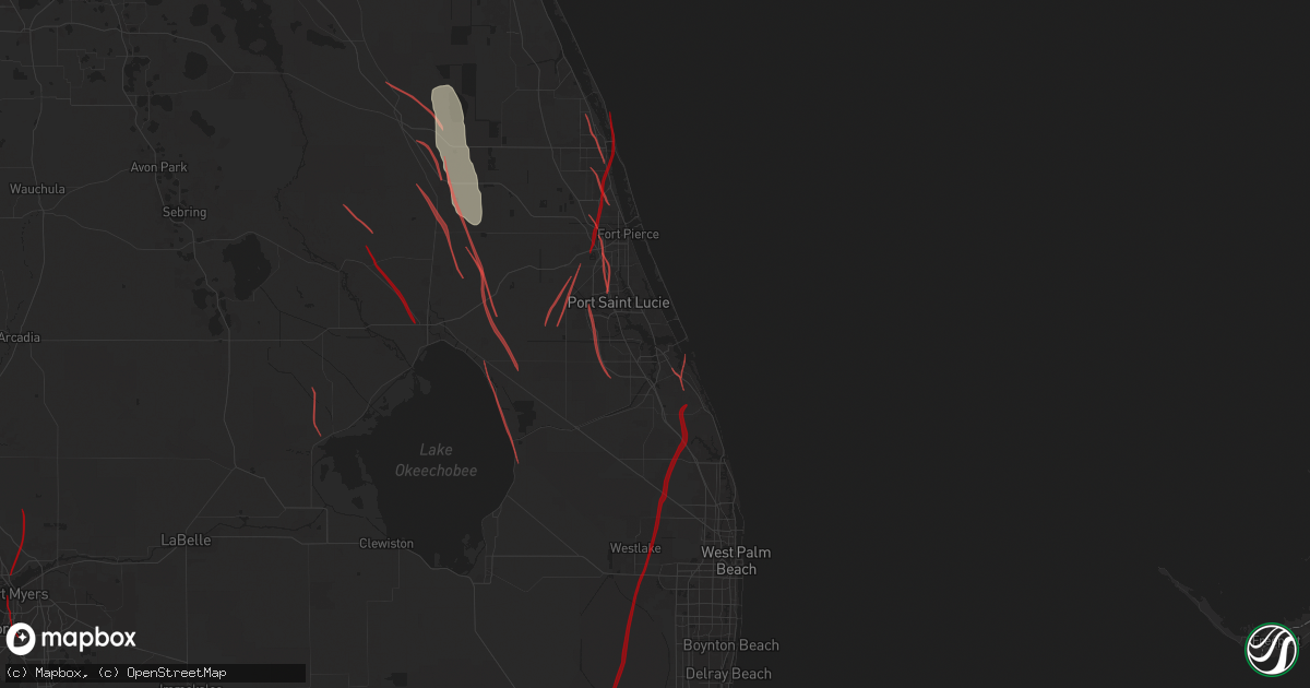
Hail Map in Stuart, FL on October 9, 2024
Get this storm
October 9 map
$229
one time, instant access
Download today. No call, no setup
Keep the $229
Bought the map and want the full workflow? Apply the entire $229 to a subscription within 7 days. None of it is wasted.
Every map, not just this one
This buys you this map. Subscription and you get every map we run, in the markets you choose from a few cities to whole states to nationwide. Plus real-time alerts the moment a storm fires.
Contact data
Name, contact info, occupancy, even credit band for addresses in the footprint. You go from where it hit to who to call.
Become the source they trust
Unlimited branding weather history reports on demand. You already have the documented answer ready for the property owner, and you are the one who showed up with it.
Property data and RoofTrace estimates
Pull up any address you have got, its value and the exact code rules for that jurisdiction, straight from One Click Code. Then RoofTrace estimates the squares, pitch, and roof value, priced the way you price.
Storm reports in Stuart, FL
Stuart, FL
| Date | Description |
|---|---|
| 10/09/20244:40 PM CDT | A trained storm spotter reported a tornado with damage to roofs and trees. |
| 10/09/20244:18 PM CDT | Martin county fire rescue reported several homes damaged and several trees down in |
| 10/09/20244:18 PM CDT | Martin county fire rescue reported severa |
| 10/09/20244:18 PM CDT | Martin county fire rescue reported several homes damaged and several trees down in the area of se federal highway and se colonial drive. |
| 10/09/20243:10 PM CDT | Multiple reports of a tornado near us 1 and cove rd. Reports of branches down and minor damage to a home. |
| 10/09/20243:10 PM CDT | Reports of damage along us1; bent power poles... Business signs destroyed... Minor structural damage & trees down. |
All Cities Impacted by Hail Map on October 9, 2024
- Clewiston, FL
- Chalmers, IN
- Ochopee, FL
- Moore Haven, FL
- Okeechobee, FL
- Saint James City, FL
- Canal Point, FL
- North Fort Myers, FL
- Punta Gorda, FL
- Fort Myers, FL
- Lorida, FL
- Vero Beach, FL
- Venus, FL
- Lake Placid, FL
- Palm City, FL
- Port Saint Lucie, FL
- Cape Coral, FL
- Fort Pierce, FL
- Bonita Springs, FL
- Estero, FL
- Naples, FL
- Saint Cloud, FL
- Hobe Sound, FL
- Stuart, FL
- Saint Petersburg, FL
- Pinellas Park, FL
- Indian Rocks Beach, FL
- Seminole, FL
- Ruskin, FL
- North Port, FL
- Port Charlotte, FL
- Venice, FL
- Nokomis, FL
- Fort Myers Beach, FL
- Englewood, FL
- Rotonda West, FL
- Sarasota, FL
- Placida, FL
- Bokeelia, FL
- Sanibel, FL
- Captiva, FL
- Boca Grande, FL
- Osprey, FL
- Longboat Key, FL
- Bradenton, FL
- Bradenton Beach, FL
- Cortez, FL
- Anna Maria, FL
- Ellenton, FL
- Palmetto, FL
- Parrish, FL
- Terra Ceia, FL
- Wimauma, FL
- Sebastian, FL
- Melbourne Beach, FL
- Grant, FL
- Malabar, FL
- Dunedin, FL
- Clearwater Beach, FL
- Clearwater, FL
- Belleair Beach, FL
- Largo, FL
- Wellington, FL
- Loxahatchee, FL
- West Palm Beach, FL
- Palm Beach Gardens, FL
- Jupiter, FL
- Tampa, FL
- Safety Harbor, FL
- Myakka City, FL
- Cocoa Beach, FL
- Brooksville, FL
- New Port Richey, FL
- Tarpon Springs, FL
- Crystal Beach, FL
- Oldsmar, FL
- Spring Hill, FL
- Odessa, FL
- Hudson, FL
- Holiday, FL
- Land O'Lakes, FL
- Palm Harbor, FL
- Port Richey, FL
- Lutz, FL
- Dade City, FL
- Lakeland, FL
- Winter Haven, FL
- Lake Alfred, FL
- Seffner, FL
- Lithia, FL
- Mulberry, FL
- Valrico, FL
- Plant City, FL
- Apollo Beach, FL
- Auburndale, FL
- Riverview, FL
- Dover, FL
- Gibsonton, FL
- Brandon, FL
- Lake Wales, FL
- Bowling Green, FL
- Homeland, FL
- Sun City Center, FL
- Haines City, FL
- Fort Meade, FL
- Bradley, FL
- Eagle Lake, FL
- Eaton Park, FL
- Bartow, FL
- Kathleen, FL
- Polk City, FL
- Zephyrhills, FL
- Thonotosassa, FL
- Webster, FL
- Wesley Chapel, FL
- San Antonio, FL
- Arcadia, FL
- Zolfo Springs, FL
- Ona, FL
- Wauchula, FL
- Kissimmee, FL
- Clermont, FL
- Winter Garden, FL
- Davenport, FL
- Dundee, FL
- Lake Hamilton, FL
- Montverde, FL
- Howey In The Hills, FL
- Eustis, FL
- Tavares, FL
- Mount Dora, FL
- Yalaha, FL
- Grand Island, FL
- Astatula, FL
- Mascotte, FL
- Leesburg, FL
- Groveland, FL
- Lecanto, FL
- Coleman, FL
- Homosassa, FL
- The Villages, FL
- Wildwood, FL
- Bushnell, FL
- Fruitland Park, FL
- Lake Panasoffkee, FL
- Center Hill, FL
- Floral City, FL
- Inverness, FL
- Nobleton, FL
- Sumterville, FL
- Lady Lake, FL
- Okahumpka, FL
- Oxford, FL
- Weirsdale, FL
- Summerfield, FL
- Umatilla, FL
- Avon Park, FL
- Frostproof, FL
- Quail, TX
- Wellington, TX
- Mclean, TX
- Shamrock, TX
- Ocklawaha, FL
- Zellwood, FL
- De Leon Springs, FL
- Apopka, FL
- Deltona, FL
- Pierson, FL
- Sorrento, FL
- Ocoee, FL
- Astor, FL
- Debary, FL
- Altoona, FL
- Lake Helen, FL
- Ormond Beach, FL
- Sanford, FL
- Daytona Beach, FL
- Paisley, FL
- Deland, FL
- Orlando, FL
- Lake Mary, FL
- Oakland, FL
- Orange City, FL
- Longwood, FL
- Windermere, FL
- Silver Springs, FL
- Belleview, FL
- Hernando, FL
- Dunnellon, FL
- Ocala, FL
- Winter Park, FL
- Nalcrest, FL
- Mims, FL
- Osteen, FL
- Winter Springs, FL
- Indian Lake Estates, FL
- Oviedo, FL
- Sebring, FL
- Gotha, FL
- Edgewater, FL
- Christmas, FL
- Kenansville, FL
- Altamonte Springs, FL
- Maitland, FL
- Lakeshore, FL
- Casselberry, FL
- New Smyrna Beach, FL
- Waverly, FL
- Geneva, FL
- Port Orange, FL
- Oak Hill, FL
- Titusville, FL
- Babson Park, FL
- Intercession City, FL
- Melbourne, FL
- Palm Bay, FL
- Merritt Island, FL
- Satellite Beach, FL
- Cape Canaveral, FL
- Rockledge, FL
- Patrick Afb, FL
- Indialantic, FL
- Cocoa, FL
- River Ranch, FL
- Palm Coast, FL
- Bunnell, FL
- Flagler Beach, FL
- Alva, FL
- Lehigh Acres, FL
- Labelle, FL
- Palmdale, FL
- Fellsmere, FL
- Indiantown, FL
- Jensen Beach, FL
- Atlantic Beach, FL
- Jacksonville, FL
- Neptune Beach, FL
- Saint Augustine, FL
- Hastings, FL
- Seville, FL
- Fort McCoy, FL
- Key West, FL


