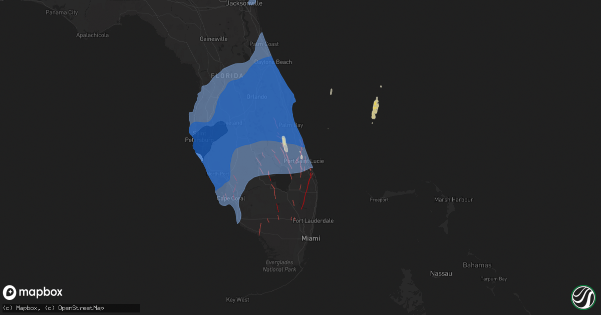
Hail Map on October 9, 2024
Get this storm
October 9 map
$229
one time, instant access
Download today. No call, no setup
Keep the $229
Bought the map and want the full workflow? Apply the entire $229 to a subscription within 7 days. None of it is wasted.
Every map, not just this one
This buys you this map. Subscription and you get every map we run, in the markets you choose from a few cities to whole states to nationwide. Plus real-time alerts the moment a storm fires.
Contact data
Name, contact info, occupancy, even credit band for addresses in the footprint. You go from where it hit to who to call.
Become the source they trust
Unlimited branding weather history reports on demand. You already have the documented answer ready for the property owner, and you are the one who showed up with it.
Property data and RoofTrace estimates
Pull up any address you have got, its value and the exact code rules for that jurisdiction, straight from One Click Code. Then RoofTrace estimates the squares, pitch, and roof value, priced the way you price.
Storm reports
Texas
| Date | Description |
|---|---|
| 10/08/20247:32 PM CDT | 62 mph wind gust observed from a decaying thunderstorm at the dozier mesonet. |
Florida
| Date | Description |
|---|---|
| 10/09/20246:29 PM CDT | The asos at the leesburg international airport measured a wind gust of 58mph/50kts from the northeast. |
| 10/09/20245:15 PM CDT | Ussf wind sensor on tower 108 measured a wind gust of 60mph/52kt from the east on october 9 at 6:15 pm et. Sensor elevation is 54 feet. |
| 10/09/20244:58 PM CDT | Social media report of roof damage to several homes off of midway rd in fort pierce. Time estimate via radar. |
| 10/09/20244:52 PM CDT | Corrects previous tornado report from 1 ene cocoa beach. Roof ripped off of well fargo bank near a1a and s banana river blvd in cocoa beach. Time estimated via radar. |
| 10/09/20244:52 PM CDT | Roof ripped off of well fargo bank near us 1 and s banana river blvd in cocoa beach. Time estimated via radar. |
| 10/09/20244:42 PM CDT | Reports of multiple cars flipped over... Trees down... Powerlines down... And roof damage in the indian river estates area in ft. Pierce. Time estimated via radar. |
| 10/09/20244:40 PM CDT | A trained storm spotter reported a tornado with damage to roofs and trees. |
| 10/09/20244:32 PM CDT | Heavily damaged or destroyed homes in the spanish lakes community in fort pierce. |
| 10/09/20244:29 PM CDT | Report of trees down on beachland blvd and a1a by the marine bank building in vero beach. Time estimated via radar. |
| 10/09/20244:18 PM CDT | Martin county fire rescue reported several homes damaged and several trees down in the area of se federal highway and se colonial drive. |
| 10/09/20244:18 PM CDT | Martin county fire rescue reported severa |
| 10/09/20244:18 PM CDT | Martin county fire rescue reported several homes damaged and several trees down in |
| 10/09/20244:15 PM CDT | Multiple reports of a large and destructive tornado with significant damage near lakewood park. |
| 10/09/20244:10 PM CDT | Mesonet station kf45 north palm beach county general reported a wind gust of 92mph as a confirmed tornado on the ground passed over or very near the airport. |
| 10/09/20244:09 PM CDT | Social media report of multiple aircraft heavily damaged or destroyed near the fort pierce airport. Time estimated via radar. |
| 10/09/20244:07 PM CDT | Social media report of a tornado on the ground nw of port st. Lucie as seen on the fdot camera on florida turnpike at mile marker 165. |
| 10/09/20244:06 PM CDT | Fdot cameras at mile markers 133 and 132 on interstate 95 in fort pierce shows debris flying around and a tornado moving across the image. |
| 10/09/20244:02 PM CDT | Reports of damage to a truck stop... Trees down... And powerlines down around the area of orange ave near interstate 95 in fort pierce. |
| 10/09/20243:58 PM CDT | First video evidence of confirmed tornado near southern blvd that will pass west of palm beach gardens and cross bee line highway before crossing the palm beach county |
| 10/09/20243:38 PM CDT | Two different spotter reports of a tornado on the ground. Pending storm survey. |
| 10/09/20243:37 PM CDT | Fdot camera on interstate 95 going northbound at mile marker 133 shows a tornado in ft. Pierce. |
| 10/09/20243:33 PM CDT | Corrects previous tornado report from 4 w lion country safari park. Two different spotter reports of a tornado on the ground. Time corrected based on storm survey findi |
| 10/09/20243:26 PM CDT | Report of a tornado in west indian river county... Near yeehaw junction. Report from sr-60 looking west towards yeehaw junction. Time estimate via radar. |
| 10/09/20243:13 PM CDT | Building damage to the commerce glass building... Street lights damage... And palm trees down in downtown vero beach on commerce ave and 20th st. Time estimate via rada |
| 10/09/20243:10 PM CDT | Reports of damage along us1; bent power poles... Business signs destroyed... Minor structural damage & trees down. |
| 10/09/20243:10 PM CDT | Multiple reports of a tornado near us 1 and cove rd. Reports of branches down and minor damage to a home. |
| 10/09/20243:01 PM CDT | Multiple reports of the st. Lucie county sheriffs office on the 4700 block of west midway in ft. Pierce sustaining damage. Time estimated via radar. |
| 10/09/20243:00 PM CDT | Observed tornado with trees down near orange blossom neighborhood. |
| 10/09/20242:55 PM CDT | Trained spotter reports a tornado touchdown on us-192 between deer park and holopaw. |
| 10/09/20242:38 PM CDT | Asos station kvrb vero beach. |
| 10/09/20242:24 PM CDT | Social media reports of damage to fences and minor damage to mailboxes in the location of torino parkway area around nw zinnia st and nw verdi ct in port saint lucie. T |
| 10/09/20242:08 PM CDT | Public reports of fence damage in the torino area of port st lucie. Time estimated via radar. |
| 10/09/20242:05 PM CDT | Reports of damage near nw verdi ct in port st lucie. Time estimated via radar. |
| 10/09/20241:53 PM CDT | Awos station kapf 1 ene naples reported a wind gust of 58mph as a band of hurricane milton moved through the area. |
| 10/09/20241:49 PM CDT | Corrects previous tornado report from 7 wnw lion country safari park. Corrects previous tornado report from 7 wnw lion country safari park. Spotter witnessed tornado to |
| 10/09/20241:38 PM CDT | Video received of tree damage on sw gatlin blvd near sw rosser blvd in port st lucie. Time estimated via radar. |
| 10/09/20241:37 PM CDT | Received photos of tree... Roof... And window damage in the newport isles subdivision. Time estimated via radar. |
| 10/09/20241:30 PM CDT | *** 1 inj *** reports of damage to a mobile home park in lake placid. |
| 10/09/20241:24 PM CDT | Start point of the ef3 lakeport tornado. Time estimated off of kamx. |
| 10/09/20241:20 PM CDT | Trees snapped across sam jones trail from fpl solar farm. This is a new tornado report after a nws storm survey. |
| 10/09/20241:20 PM CDT | Bent utility pole near agricultural facility. This is a new tornado report assessed by a nws storm survey. |
| 10/09/20241:18 PM CDT | Trained spotter reported a tornado on the ground near i-95 and sw becker rd moving north. Trees reported down. |
| 10/09/20241:16 PM CDT | Nws storm survey found small limbs broken by a tornadic circulation. This is a new tornado report. |
| 10/09/20241:15 PM CDT | Video received of tree... Fence... And patio damage north of sw becker rd and east of i-95. Time estimated via radar. |
| 10/09/20241:15 PM CDT | Sheriff reports damage to tropical harbor mobile home park in lake placid/sylvan shores from apparent tornado |
| 10/09/20241:14 PM CDT | Preliminary starting point for a confirmed tornado that formed near the hendry and glades county line... Crossing us 27 and moving into the brighton reservation. Pendin |
| 10/09/20241:11 PM CDT | Emergency manager confirms a tornado on the ground near dixie ranch acres. |
| 10/09/20241:02 PM CDT | Emergency manager reports a confirmed tornado flipped a truck on interstate 95 at mile marker 109. |
| 10/09/20241:00 PM CDT | Video and images of large wedge tornado on the ground moving nne near placid lakes near state rd 70 and us 27. |
| 10/09/202412:50 PM CDT | Pictures of large tornado near brighton. |
| 10/09/202411:45 AM CDT | Social media pictures and videos of tornado near wild island. |
| 10/09/202411:20 AM CDT | Social media videos of tornado and damage near se area of fort myers country club. |
| 10/09/202411:15 AM CDT | Social media video and images showing tornado damage to homes near colonial blvd and orangewood ave. |
| 10/09/202411:13 AM CDT | Multiple reports of a tornado along the eastern shore of lake okeechobee near port mayaca. |
| 10/09/202410:55 AM CDT | Lee county sheriffs office report tornado damage in matlacha. |
| 10/09/202410:44 AM CDT | Beginning time/location of the ef1 lakeport tornado via kamx and nws storm survey. |
| 10/09/202410:42 AM CDT | Preliminary starting point for a confirmed tornado that moved from hendry into glades county crossing sr 80. Pending storm survey. |
| 10/09/202410:40 AM CDT | Tornado was observed south of us98... Briefly lifted... And returned just north of us98. It continued for 10 minutes as it went north. This is a new tornado report base |
| 10/09/20248:42 AM CDT | Preliminary starting point for a confirmed tornado that crossed i-75 near the miccosukee service station and moved north to the brighton reservation. Pending survey wil |
| 10/09/20243:31 AM CDT | The asos at the daytona beach international airport measured a wind gust of 87mph/76kts from the north. |
| 10/09/20243:12 AM CDT | The asos at the sanford international airport measured a wind gust of 74mph/64kts from the north. |
| 10/09/20242:21 AM CDT | The asos at the daytona beach international airport measured a wind gust of 84mph/73kts from the north. |
| 10/09/20241:30 AM CDT | The asos at the daytona beach international airport measured a wind gust of 82mph/71kts from the north-northeast. |
| 10/09/20241:10 AM CDT | The asos at the vero beach regional airport measured a wind gust of 84mph/73kts from the south. |
| 10/09/202412:55 AM CDT | The ksc3 tower reported a wind gust of 64mph/56kt from the se. |
| 10/09/202412:55 AM CDT | Ussf wind sensor on tower 303 measured a wind gust of 66mph/57kt from the northwest on october 10 at 1:55 am et. Sensor elevation is 54 feet. |
| 10/09/202412:55 AM CDT | The ksc20 tower reported a wind gust of 81 mph/70 kts from the se. |
| 10/09/202412:45 AM CDT | Ksc403 tower reported a wind gust of 70mph/61kt from the se. |
| 10/09/202412:40 AM CDT | The ksc3 tower reported a wind gust of 79mph/69 kt from the southeast. |
| 10/09/202412:32 AM CDT | The asos at the melbourne international airport measured a wind gust of 78mph/68kts from the south-southeast. |
| 10/09/202412:31 AM CDT | The asos at the melbourne international airport measured a wind gust of 77mph/67kts from the south-southeast. |
| 10/09/202412:20 AM CDT | The ksc62 tower reported a wind gust of 68mph/59kt from se. |
| 10/09/202412:10 AM CDT | Ussf wind sensor on tower 108 measured a wind gust of 67mph/58kt from the northwest on october 10 at 1:10 am et. Sensor elevation is 54 feet. |
| 10/09/202412:00 AM CDT | The ksc803 tower reported a wind gust of 70mph/61 kt from the se. |
| 10/09/202412:00 AM CDT | The ksc21 tower reported a wind gust of 64kt/74mph from se. |
| 10/08/202411:55 PM CDT | Tower 003 reported a wind gust of 76 mph/66kts from the southeast. |
| 10/08/202411:53 PM CDT | The asos at the vero beach regional airport measured a wind gust of 70mph/61kts from the south. |
| 10/08/202411:13 PM CDT | The asos at the vero beach regional airport measured a wind gust of 64mph/56kts from the south-southeast. |
| 10/08/202411:12 PM CDT | The asos at the treasure coast international airport measured a wind gust of 60mph/52kts from the south. |
| 10/08/202411:11 PM CDT | The asos at the orlando international airport measured a wind gust of 86mph/75kts from the east-northeast. |
| 10/08/202411:10 PM CDT | The asos at the daytona beach international airport measured a wind gust of 78mph/68kts from the northeast. |
| 10/08/202410:36 PM CDT | The asos at the daytona beach international airport measured a wind gust of 76mph/66kts from the northeast. |
| 10/08/202410:17 PM CDT | The asos at the orlando executive airport measured a wind gust of 74mph/64kts from the east-northeast. |
| 10/08/202410:09 PM CDT | The asos at the daytona beach international airport measured a wind gust of 75mph/65kts from the northeast. |
| 10/08/20249:53 PM CDT | The asos at the orlando executive airport measured a wind gust of 60mph/52kts from the east-northeast. |
| 10/08/20249:41 PM CDT | The asos at the melbourne international airport measured a wind gust of 68mph/59kts from the southeast. |
| 10/08/20249:32 PM CDT | The asos at the leesburg international airport measured a wind gust of 75mph/65kts from the northeast. |
| 10/08/20249:25 PM CDT | Corrects previous tstm wnd gst report from 2 sse midway. The asos at the sanford international airport measured a wind gust of 60mph/52kts from the northeast. |
| 10/08/20249:19 PM CDT | The asos at the daytona beach international airport measured a wind gust of 69mph/60kts from the northeast. |
| 10/08/20248:21 PM CDT | The asos at the leesburg international airport measured a wind gust of 71mph/62kts from the northeast. |
| 10/08/20248:20 PM CDT | The asos at the daytona beach international airport measured a wind gust of 64mph/56kts from the northeast. |
Cities Impacted by Hail Map on October 9, 2024
- Clewiston, FL
- Chalmers, IN
- Ochopee, FL
- Moore Haven, FL
- Okeechobee, FL
- Saint James City, FL
- Canal Point, FL
- North Fort Myers, FL
- Punta Gorda, FL
- Fort Myers, FL
- Lorida, FL
- Vero Beach, FL
- Venus, FL
- Lake Placid, FL
- Palm City, FL
- Port Saint Lucie, FL
- Cape Coral, FL
- Fort Pierce, FL
- Bonita Springs, FL
- Estero, FL
- Naples, FL
- Saint Cloud, FL
- Hobe Sound, FL
- Stuart, FL
- Saint Petersburg, FL
- Pinellas Park, FL
- Indian Rocks Beach, FL
- Seminole, FL
- Ruskin, FL
- North Port, FL
- Port Charlotte, FL
- Venice, FL
- Nokomis, FL
- Fort Myers Beach, FL
- Englewood, FL
- Rotonda West, FL
- Sarasota, FL
- Placida, FL
- Bokeelia, FL
- Sanibel, FL
- Captiva, FL
- Boca Grande, FL
- Osprey, FL
- Longboat Key, FL
- Bradenton, FL
- Bradenton Beach, FL
- Cortez, FL
- Anna Maria, FL
- Ellenton, FL
- Palmetto, FL
- Parrish, FL
- Terra Ceia, FL
- Wimauma, FL
- Sebastian, FL
- Melbourne Beach, FL
- Grant, FL
- Malabar, FL
- Dunedin, FL
- Clearwater Beach, FL
- Clearwater, FL
- Belleair Beach, FL
- Largo, FL
- Wellington, FL
- Loxahatchee, FL
- West Palm Beach, FL
- Palm Beach Gardens, FL
- Jupiter, FL
- Tampa, FL
- Safety Harbor, FL
- Myakka City, FL
- Cocoa Beach, FL
- Brooksville, FL
- New Port Richey, FL
- Tarpon Springs, FL
- Crystal Beach, FL
- Oldsmar, FL
- Spring Hill, FL
- Odessa, FL
- Hudson, FL
- Holiday, FL
- Land O'Lakes, FL
- Palm Harbor, FL
- Port Richey, FL
- Lutz, FL
- Dade City, FL
- Lakeland, FL
- Winter Haven, FL
- Lake Alfred, FL
- Seffner, FL
- Lithia, FL
- Mulberry, FL
- Valrico, FL
- Plant City, FL
- Apollo Beach, FL
- Auburndale, FL
- Riverview, FL
- Dover, FL
- Gibsonton, FL
- Brandon, FL
- Lake Wales, FL
- Bowling Green, FL
- Homeland, FL
- Sun City Center, FL
- Haines City, FL
- Fort Meade, FL
- Bradley, FL
- Eagle Lake, FL
- Eaton Park, FL
- Bartow, FL
- Kathleen, FL
- Polk City, FL
- Zephyrhills, FL
- Thonotosassa, FL
- Webster, FL
- Wesley Chapel, FL
- San Antonio, FL
- Arcadia, FL
- Zolfo Springs, FL
- Ona, FL
- Wauchula, FL
- Kissimmee, FL
- Clermont, FL
- Winter Garden, FL
- Davenport, FL
- Dundee, FL
- Lake Hamilton, FL
- Montverde, FL
- Howey In The Hills, FL
- Eustis, FL
- Tavares, FL
- Mount Dora, FL
- Yalaha, FL
- Grand Island, FL
- Astatula, FL
- Mascotte, FL
- Leesburg, FL
- Groveland, FL
- Lecanto, FL
- Coleman, FL
- Homosassa, FL
- The Villages, FL
- Wildwood, FL
- Bushnell, FL
- Fruitland Park, FL
- Lake Panasoffkee, FL
- Center Hill, FL
- Floral City, FL
- Inverness, FL
- Nobleton, FL
- Sumterville, FL
- Lady Lake, FL
- Okahumpka, FL
- Oxford, FL
- Weirsdale, FL
- Summerfield, FL
- Umatilla, FL
- Avon Park, FL
- Frostproof, FL
- Quail, TX
- Wellington, TX
- Mclean, TX
- Shamrock, TX
- Ocklawaha, FL
- Zellwood, FL
- De Leon Springs, FL
- Apopka, FL
- Deltona, FL
- Pierson, FL
- Sorrento, FL
- Ocoee, FL
- Astor, FL
- Debary, FL
- Altoona, FL
- Lake Helen, FL
- Ormond Beach, FL
- Sanford, FL
- Daytona Beach, FL
- Paisley, FL
- Deland, FL
- Orlando, FL
- Lake Mary, FL
- Oakland, FL
- Orange City, FL
- Longwood, FL
- Windermere, FL
- Silver Springs, FL
- Belleview, FL
- Hernando, FL
- Dunnellon, FL
- Ocala, FL
- Winter Park, FL
- Nalcrest, FL
- Mims, FL
- Osteen, FL
- Winter Springs, FL
- Indian Lake Estates, FL
- Oviedo, FL
- Sebring, FL
- Gotha, FL
- Edgewater, FL
- Christmas, FL
- Kenansville, FL
- Altamonte Springs, FL
- Maitland, FL
- Lakeshore, FL
- Casselberry, FL
- New Smyrna Beach, FL
- Waverly, FL
- Geneva, FL
- Port Orange, FL
- Oak Hill, FL
- Titusville, FL
- Babson Park, FL
- Intercession City, FL
- Melbourne, FL
- Palm Bay, FL
- Merritt Island, FL
- Satellite Beach, FL
- Cape Canaveral, FL
- Rockledge, FL
- Patrick Afb, FL
- Indialantic, FL
- Cocoa, FL
- River Ranch, FL
- Palm Coast, FL
- Bunnell, FL
- Flagler Beach, FL
- Alva, FL
- Lehigh Acres, FL
- Labelle, FL
- Palmdale, FL
- Fellsmere, FL
- Indiantown, FL
- Jensen Beach, FL
- Atlantic Beach, FL
- Jacksonville, FL
- Neptune Beach, FL
- Saint Augustine, FL
- Hastings, FL
- Seville, FL
- Fort McCoy, FL
- Key West, FL