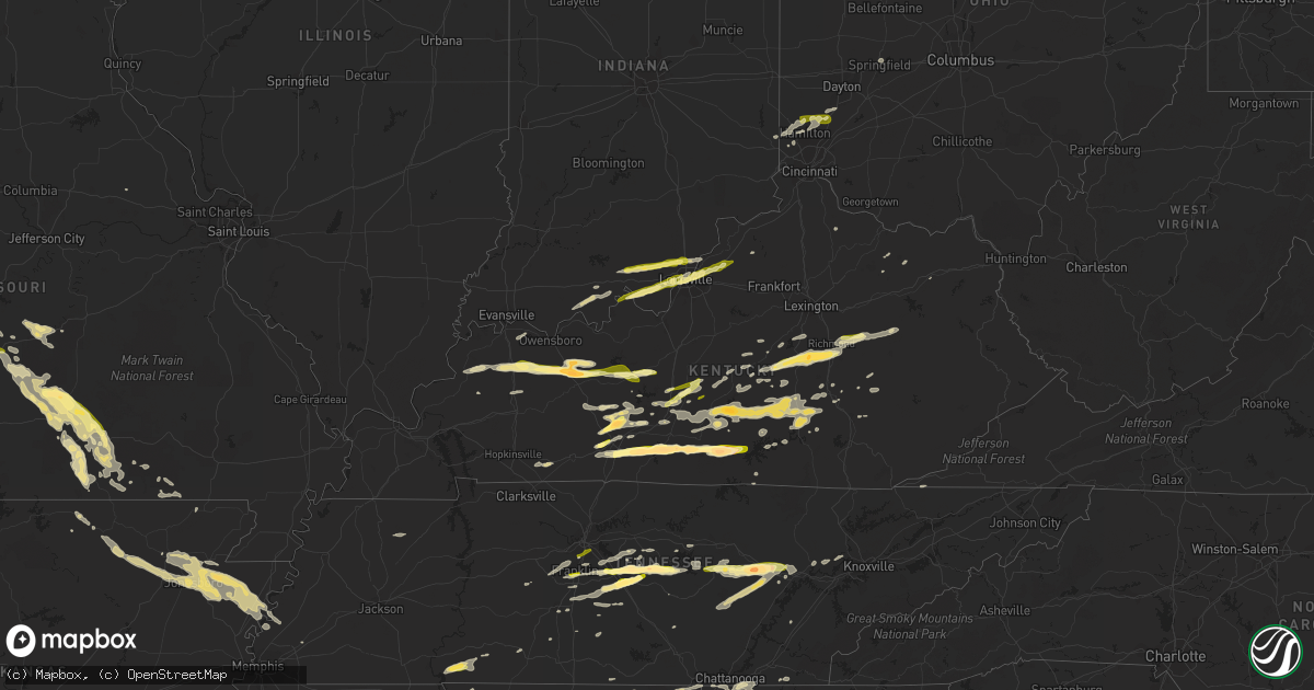
Hail Map in Kentucky on October 6, 2014
Get this storm
October 6 map
$229
one time, instant access
Download today. No call, no setup
Keep the $229
Bought the map and want the full workflow? Apply the entire $229 to a subscription within 7 days. None of it is wasted.
Every map, not just this one
This buys you this map. Subscription and you get every map we run, in the markets you choose from a few cities to whole states to nationwide. Plus real-time alerts the moment a storm fires.
Contact data
Name, contact info, occupancy, even credit band for addresses in the footprint. You go from where it hit to who to call.
Become the source they trust
Unlimited branding weather history reports on demand. You already have the documented answer ready for the property owner, and you are the one who showed up with it.
Property data and RoofTrace estimates
Pull up any address you have got, its value and the exact code rules for that jurisdiction, straight from One Click Code. Then RoofTrace estimates the squares, pitch, and roof value, priced the way you price.
Storm reports in Kentucky
Kentucky
| Date | Description |
|---|---|
| 10/06/20146:50 PM CDT | A local report indicates 1.00 inch wind near DUNDEE |
| 10/06/20146:45 PM CDT | Lots of quarter sized hail fell at conley bottom resort with a wind gust measured at 47 mph. |
| 10/06/20146:21 PM CDT | A local report indicates 1.00 inch wind near DUNDEE |
| 10/06/20146:15 PM CDT | Cocorahs report of ping pong size hail with leaf damage |
| 10/06/20146:05 PM CDT | Damage to homes and vehicles |
| 10/06/20146:04 PM CDT | A local report indicates 1.75 inch wind near 7 N HARTFORD |
| 10/06/20146:03 PM CDT | A local report indicates 1.25 inch wind near 5 NE BURKESVILLE |
| 10/06/20146:01 PM CDT | Hail covering the ground |
| 10/06/20145:18 PM CDT | A local report indicates 1.75 inch wind near 2 E EIGHTY EIGHT |
| 10/06/20145:16 PM CDT | A local report indicates 1.75 inch wind near TEMPLE HILL |
| 10/06/20145:10 PM CDT | Hail between half dollar and golf ball size. |
| 10/06/20145:02 PM CDT | 2-inch hail reported near haywood at skaggs creek and matthews mill road |
| 10/06/20144:50 PM CDT | Multiple trees down on highway 2498. |
| 10/06/20144:45 PM CDT | Quarter sized hail reported near the town of yesse. |
| 10/06/20144:45 PM CDT | Multiple trees down on highway 460. |
| 10/06/20144:45 PM CDT | Trees down on highway 844. |
| 10/06/20144:42 PM CDT | A local report indicates 1.75 inch wind near 10 N SCOTTSVILLE |
| 10/06/20144:25 PM CDT | A local report indicates 1.00 inch wind near SUMMERSVILLE |
| 10/06/20144:15 PM CDT | Broadcast media relayed report of golf ball size hail in the anna community of northern warren county |
| 10/06/20144:13 PM CDT | Quarter size or larger hail reported. Time estimated by radar. No wind damage noticed at this time. |
| 10/06/20144:12 PM CDT | A local report indicates 1.00 inch wind near MUNFORDVILLE |
| 10/06/20143:47 PM CDT | Quarter size hail reported and winds between 30 and 35 miles per hour. |
| 10/06/20143:45 PM CDT | Madison county mesonet measured 62.6 mph wind gust |
| 10/06/20143:45 PM CDT | Picture via twitter of ping pong to potentially golf ball size hail just outside of paint lick |
| 10/06/20143:40 PM CDT | A local report indicates 1.00 inch wind near LANCASTER |
| 10/06/20143:32 PM CDT | Pea to quarter size hail reported on the west side of bowling green |
| 10/06/20143:31 PM CDT | A local report indicates 1.00 inch wind near 3 WNW LANCASTER |
| 10/06/20143:22 PM CDT | Mping report of quarter size hail outside of stanford |
| 10/06/20142:40 PM CDT | Law enforcement reported dime to quarter size hail in munfordville |
| 10/06/20142:23 PM CDT | Spotter called in report of quarter to half-dollar size hail falling |
| 10/06/20142:15 PM CDT | Picture via facebook of quarter size hail |
| 10/06/20149:26 AM CDT | Quarter size hail reported in woodlawn park. Picture via twitter. |
| 10/06/20149:24 AM CDT | Picture via facebook of measured dime to quarter size hail near the intersection of frankfort and ewing ave. |
| 10/06/20149:23 AM CDT | Picture via twitter of quarter size hail in louisville |
| 10/06/20144:23 AM CDT | A tree was blown down on jarvis ave in somerset. The downed tree also brought down power lines between hwy 914 and bourne ave in somerset. |
| 10/06/20143:24 AM CDT | Delayed report. Boater on green river lake at holmes bend dock reported a hail storm that damaged covers on the boats around him. Time estimated based on radar data. |
| 10/05/201410:30 PM CDT | Trees down on highway 1110 between the 11 and 12 mile marker. |
| 10/05/201410:05 PM CDT | Trees down on highway 1081. |
| 10/05/201410:00 PM CDT | Trees down on highway 844. |
| 10/05/20149:50 PM CDT | Trees down near hazel green on highways 191 and 1010. |
| 10/05/20149:45 PM CDT | Quarter to half dollar sized hail was reported via social media. |
| 10/05/20149:40 PM CDT | One tree down on the mountain parkway. |
| 10/05/20149:32 PM CDT | Multiple trees down on hwy 1057 and 213 with hail up to the size of dimes in the area. |
| 10/05/20149:03 PM CDT | Thunderstorm winds downed a tree near the intersection of concord road and state highway 52 east of irvine. |
| 10/05/20148:52 PM CDT | A tree fell on a house in buckeye...which is on the garrard madison county line. |
| 10/05/20147:45 PM CDT | A facebook image showed that quarter sized hail fell on clarkson |
| 10/05/20147:45 PM CDT | A spotter reported that two trees were downed by winds east of hodgenville. One fell along bardstown road. Another tree fell along state highway 222. |
| 10/05/20147:44 PM CDT | Estimated winds 40 to 50 mph and hail ranging from dime to quarter size. |
| 10/05/20147:37 PM CDT | A local report indicates 1.00 inch wind near LEITCHFIELD |
| 10/05/20147:33 PM CDT | Emergency management reported two trees down in central hardin. They fell along valley creek road near e-town. The other fell along harris school road near cecilia |
| 10/05/20147:17 PM CDT | Hail the size of quarters covered the ground. |
| 10/05/20147:06 PM CDT | Quarter size hail lasted for 15 minutes. 1 minute of half dollar size hail. |
All States Impacted by Hail Map on October 6, 2014
Cities Impacted by Hail Map on October 6, 2014
- Danville, KY
- Perryville, KY
- Lebanon, MO
- Eldridge, MO
- Center, TX
- Bradfordsville, KY
- Lebanon, KY
- Gravel Switch, KY
- Russellville, AL
- Flat Rock, AL
- Higdon, AL
- Blue Springs, MS
- Stanford, KY
- Hustonville, KY
- Cullman, AL
- Vinemont, AL
- Rumsey, KY
- Beaver Dam, KY
- Whitesville, KY
- Hartford, KY
- Sebree, KY
- Olaton, KY
- Slaughters, KY
- Calhoun, KY
- Caneyville, KY
- Dixon, KY
- Fordsville, KY
- Utica, KY
- Horse Branch, KY
- Livermore, KY
- Blountsville, AL
- Holly Pond, AL
- Estillfork, AL
- New Market, AL
- Russell Springs, KY
- Woodbury, TN
- Liberty, TN
- Hanceville, AL
- London, KY
- Lawrenceburg, TN
- Somerset, KY
- Coushatta, LA
- Munfordville, KY
- Bonnieville, KY
- Olive Hill, KY
- Oakland, KY
- Bowling Green, KY
- Elkhart, TX
- Grapeland, TX
- Flemingsburg, KY
- Newburg, MO
- Duke, MO
- Inez, TX
- Summer Shade, KY
- Glasgow, KY
- Burkesville, KY
- Edmonton, KY
- Alvaton, KY
- Eighty Eight, KY
- Lucas, KY
- Scottsville, KY
- Chickamauga, GA
- La Fayette, GA
- Rock Spring, GA
- Waynesville, MO
- Crocker, MO
- Nacogdoches, TX
- Readyville, TN
- Parksville, KY
- Paint Lick, KY
- Junction City, KY
- Lancaster, KY
- Berea, KY
- Richmond, KY
- Lake City, AR
- Black Oak, AR
- Monette, AR
- Etowah, AR
- Jonesboro, AR
- Manila, AR
- Osceola, AR
- Hickory Flat, MS
- Blue Mountain, MS
- Plantersville, MS
- Shannon, MS
- Nettleton, MS
- Okolona, MS
- Kerens, TX
- Xenia, IL
- Brookland, AR
- Dyess, AR
- Strawberry, AR
- Evening Shade, AR
- Bono, AR
- Keiser, AR
- Caraway, AR
- Cash, AR
- Hardy, AR
- Ash Flat, AR
- Wilson, AR
- State University, AR
- Paragould, AR
- Lepanto, AR
- Walnut Ridge, AR
- Poughkeepsie, AR
- Trumann, AR
- Alicia, AR
- Lynn, AR
- Bay, AR
- Smithville, AR
- Mountain View, MO
- Elk Creek, MO
- Yukon, MO
- Trenton, OH
- Hamilton, OH
- Middletown, OH
- Phil Campbell, AL
- Spruce Pine, AL
- Converse, LA
- Many, LA
- Mansfield, LA
- Zwolle, LA
- Noble, LA
- Carthage, TX
- Logansport, LA
- Charlestown, IN
- Crossville, TN
- Falcon, MO
- Seven Mile, OH
- Rockfield, KY
- Pikeville, TN
- Spencer, TN
- Gurley, AL
- Huntsville, AL
- San Augustine, TX
- Lebanon, TN
- Salem, IL
- Alma, IL
- Iuka, IL
- Kinmundy, IL
- Waco, KY
- Irvine, KY
- Campbellsville, KY
- Columbia, KY
- Greensburg, KY
- Baytown, TX
- Kemp, TX
- Mabank, TX
- Cabool, MO
- Solo, MO
- Houston, MO
- Stevenson, AL
- Baldwyn, MS
- Dumas, MS
- New Albany, MS
- Shreveport, LA
- Trenton, GA
- Rising Fawn, GA
- Nauvoo, AL
- Jasper, AL
- Double Springs, AL
- Pleasureville, KY
- Golden, MS
- Fulton, MS
- Corydon, IN
- Mauckport, IN
- New Middletown, IN
- Battletown, KY
- Central, IN
- Greenwood, LA
- Waskom, TX
- Bethany, LA
- De Berry, TX
- Mammoth Cave, KY
- Smiths Grove, KY
- Park City, KY
- Allensville, KY
- Guthrie, KY
- Elkton, KY
- Louisville, KY
- Clay City, KY
- Haleyville, AL
- Richland, MO
- Fort Leonard Wood, MO
- Saint Robert, MO
- Dixon, MO
- Leitchfield, KY
- Millwood, KY
- Evanston, IN
- Bristow, IN
- Tell City, IN
- Milton, TN
- Ringgold, GA
- Tunnel Hill, GA
- Birch Tree, MO
- Devils Elbow, MO
- Pomona, MO
- Willow Springs, MO
- West Plains, MO
- Thayer, MO
- Couch, MO
- Stanton, KY
- Doniphan, MO
- Gatewood, MO
- Amory, MS
- Pontotoc, MS
- Nicholasville, KY
- Big Clifty, KY
- Clarkson, KY
- Ramsey, IN
- Depauw, IN
- New Salisbury, IN
- Georgetown, IN
- Palmyra, IN
- Milltown, IN
- Sellersburg, IN
- Marengo, IN
- Borden, IN
- Floyds Knobs, IN
- New Albany, IN
- Greenville, IN
- Palestine, TX
- Tennessee Colony, TX
- Athens, TX
- Guntown, MS
- Cave City, KY
- Athens, AL
- Koshkonong, MO
- Tremont, MS
- Kell, IL
- Addison, AL
- Dunnville, KY
- Bruce, MS
- Randolph, MS
- Houlka, MS
- Banner, MS
- Dundee, KY
- Columbia, TN
- Unionville, TN
- Graff, MO
- Mountain Grove, MO
- Yosemite, KY
- Windsor, KY
- Horse Cave, KY
- Science Hill, KY
- Liberty, KY
- Center, KY
- Ferguson, KY
- Gradyville, KY
- Hardyville, KY
- Elk Horn, KY
- Waynesburg, KY
- Nancy, KY
- Knifley, KY
- Bethelridge, KY
- Eubank, KY
- Kings Mountain, KY
- Walnut, MS
- Ripley, MS
- Clarksville, IN
- Masonic Home, KY
- Crestwood, KY
- Pewee Valley, KY
- Prospect, KY
- Jeffersonville, IN
- Glenview, KY
- Elizabeth, IN
- Lanesville, IN
- La Grange, KY
- Salem, AR
- Glencoe, AR
- Tenaha, TX
- Brentwood, TN
- Bear Creek, AL
- Jetson, KY
- Roundhill, KY
- Auburn, KY
- Crab Orchard, TN
- Sparta, TN
- Fremont, MO
- Springfield, KY
- Franklin, OH
- Miamisburg, OH
- Springboro, OH
- Rockwood, TN
- Rockvale, TN
- Murfreesboro, TN
- Eagleville, TN
- Albion, IL
- Summersville, MO
- Magnolia, KY
- Lascassas, TN
- Crane Hill, AL
- Arley, AL
- Logan, AL
- Houston, AL
- Myrtle, MS
- Petersburg, TN
- Hamilton, AL
- Hackleburg, AL
- Savannah, TN
- Collinwood, TN
- Lutts, TN
- Morgantown, KY
- Lynnville, TN
- Chattanooga, TN
- Fort Oglethorpe, GA
- Rossville, GA
- Silver Point, TN
- Red Bay, AL
- Lynchburg, MO
- Mount Vernon, KY
- Orlando, KY
- Pierceton, IN
- Larwill, IN
- Monticello, KY
- Livingston, KY
- Belmont, MS
- New Site, MS
- Dennis, MS
- Marietta, MS
- Smyrna, TN
- Morrison, TN
- Bridgeport, AL
- Cub Run, KY
- Auburntown, TN
- Ooltewah, TN
- Dowelltown, TN
- Henagar, AL
- Ider, AL
- Huggins, MO
- Hartville, MO
- Success, MO
- Bucyrus, MO
- Eminence, MO
- Plato, MO
- Brodhead, KY
- Walling, TN
- Beaumont, KY
- Woodburn, KY
- Breeding, KY
- Jamestown, KY
- Nolensville, TN
- Mount Sherman, KY
- Summersville, KY
- Clinton, TN
- Oak Ridge, TN
- Harriman, TN
- Alton, MO
- Watertown, TN
- Valley Head, AL
- Frenchburg, KY
- Slade, KY
- Malakoff, TX
- Waterloo, AL
- Florence, AL
- Odin, IL
- Patoka, IL
- Lamar, IN
- Troy, IN
- Leopold, IN
- Branchville, IN
- Leavenworth, IN
- Cannelton, IN
- Brownsville, KY
- Canmer, KY
- Clay, KY
- Morganfield, KY
- Sturgis, KY
- Mannsville, KY
- Wallingford, KY
- Houston, TX
- Oakwood, TX
- Fackler, AL
- Grandview, TN
- Albany, KY
- Town Creek, AL
- Mount Hope, AL
- Joaquin, TX
- Sneedville, TN
- Rose Hill, VA
- Tazewell, TN
- Manchester, KY
- La Porte, TX
- Chapel Hill, TN
- Bell Buckle, TN
- Menlo, GA
- Pisgah, AL
- Princeton, AL
- Rocky Face, GA
- Hollywood, AL
- Scottsboro, AL
- Hollytree, AL
- Old Fort, TN
- Okeana, OH
- Oxford, OH
- Tupelo, MS
- Vina, AL
- Buffalo, KY
- Harrison, OH
- Fairfield, OH
- Highlands, TX
- McKee, KY
- Mason, TN
- Booneville, MS
- League City, TX
- Friendswood, TX
- Sweeden, KY
- Bee Spring, KY
- Hoxie, AR
- Cushing, TX
- Louisville, IL
- Dieterich, IL
- Hillsboro, KY
- Grand Cane, LA
- Keatchie, LA
- Spring Hill, TN
- Thompsons Station, TN
- Franklin, TN
- Pasadena, TX
- Dayton, TX
- Apison, TN
- Falmouth, KY
- Hodges, AL
- Gleason, TN
- Vincent, KY
- Tyner, KY
- Oxford, AR
- Decatur, TN
- Athens, TN
- Smithville, TN
- Lewisburg, TN
- Lyles, TN
- Henderson, KY
- Swifton, AR
- Moulton, AL
- Cleveland, TN
- High Hill, MO
- Flintville, TN
- Fayetteville, TN
- Trinidad, TX
- Gary, TX
- Sugar Land, TX
- Missouri City, TX
- Stafford, TX
- Lookout Mountain, TN
- Flintstone, GA
- Wildwood, GA
- Lookout Mountain, GA
- Guild, TN
- Drummonds, TN
- Millington, TN
- Flat Rock, IL
- Tunas, MO
- Falkville, AL
- West Harrison, IN
- Cohutta, GA
- Mcminnville, TN
- Goshen, KY
- English, IN
- College Grove, TN
- Grovespring, MO
- Roby, MO
- Peace Valley, MO
- Webster, TX
- Shelbyville, TN
- Carbon Hill, AL
- Eldridge, AL
- Trion, GA
- Arrington, TN
- Stonewall, LA
- Frierson, LA
- La Vergne, TN
- Pall Mall, TN
- Bryant, AL
- South Pittsburg, TN
- Stoutland, MO
- Springfield, OH
- Garrison, TX
- Florien, LA
- Burlison, TN
- Munford, TN
- Brighton, TN
- Reed, KY
- Shelbyville, TX
- Bronson, TX
- Madisonville, KY
- Oliver Springs, TN
- Summerville, GA
- Trenton, KY
- Princeton, KY
- Baxter, TN
- Corning, AR
- Duck River, TN
- Franklin, KY
- Harrodsburg, KY
- White Mills, KY
- Falls Of Rough, KY
- Eastview, KY
- Joppa, AL
- Baileyton, AL
- Brandsville, MO
- Waynesboro, TN
- Smithfield, KY
- Buckner, KY
- Memphis, IN
- Pittsburg, TX
- Leesburg, TX
- Scroggins, TX
- Mount Vernon, TX
- Winona, TX
- Hawkins, TX
- Winnsboro, TX
- Gilmer, TX
- Big Sandy, TX
- Gladewater, TX
- Dike, TX
- Lake Creek, TX
- Talco, TX
- Saltillo, TX
- Mount Pleasant, TX
- Winfield, TX
- Cooper, TX
- Sulphur Bluff, TX
- Hallsville, TX
- Longview, TX
- Belmont, LA
- Kilgore, TX
- Tyler, TX
- Overton, TX
- Henderson, TX
- Somerville, OH
- Nashville, TN


