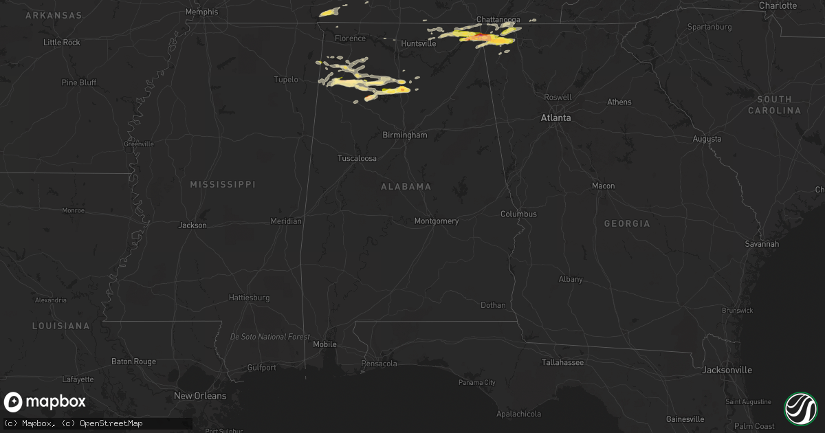
Hail Map in Alabama on October 6, 2014
Get this storm
October 6 map
$229
one time, instant access
Download today. No call, no setup
Keep the $229
Bought the map and want the full workflow? Apply the entire $229 to a subscription within 7 days. None of it is wasted.
Every map, not just this one
This buys you this map. Subscription and you get every map we run, in the markets you choose from a few cities to whole states to nationwide. Plus real-time alerts the moment a storm fires.
Contact data
Name, contact info, occupancy, even credit band for addresses in the footprint. You go from where it hit to who to call.
Become the source they trust
Unlimited branding weather history reports on demand. You already have the documented answer ready for the property owner, and you are the one who showed up with it.
Property data and RoofTrace estimates
Pull up any address you have got, its value and the exact code rules for that jurisdiction, straight from One Click Code. Then RoofTrace estimates the squares, pitch, and roof value, priced the way you price.
Storm reports in Alabama
Alabama
| Date | Description |
|---|---|
| 10/06/20146:29 PM CDT | Reported at intersection of state highway 117 and us 72. Hail was accumulating on road surface... But depth was not measured. |
| 10/06/20146:20 PM CDT | Reported at intersection of state highway 31 and cr 490. Photo was sent and hail was covering part of yard. |
| 10/06/20146:07 PM CDT | Reported on south side of cullman. |
| 10/06/20144:55 PM CDT | Report of quarter size hail in addison. Relayed via social media. Time estimated from radar. |
| 10/06/20144:54 PM CDT | Reported in the thatch community. Time estimated from radar. |
| 10/06/20144:00 PM CDT | Coop observer reported golfball sized hail on albert street in haleyville. |
| 10/05/20149:22 PM CDT | Quarter size hail falling at this time. |
All States Impacted by Hail Map on October 6, 2014
Cities Impacted by Hail Map on October 6, 2014
- Danville, KY
- Perryville, KY
- Lebanon, MO
- Eldridge, MO
- Center, TX
- Bradfordsville, KY
- Lebanon, KY
- Gravel Switch, KY
- Russellville, AL
- Flat Rock, AL
- Higdon, AL
- Blue Springs, MS
- Stanford, KY
- Hustonville, KY
- Cullman, AL
- Vinemont, AL
- Rumsey, KY
- Beaver Dam, KY
- Whitesville, KY
- Hartford, KY
- Sebree, KY
- Olaton, KY
- Slaughters, KY
- Calhoun, KY
- Caneyville, KY
- Dixon, KY
- Fordsville, KY
- Utica, KY
- Horse Branch, KY
- Livermore, KY
- Blountsville, AL
- Holly Pond, AL
- Estillfork, AL
- New Market, AL
- Russell Springs, KY
- Woodbury, TN
- Liberty, TN
- Hanceville, AL
- London, KY
- Lawrenceburg, TN
- Somerset, KY
- Coushatta, LA
- Munfordville, KY
- Bonnieville, KY
- Olive Hill, KY
- Oakland, KY
- Bowling Green, KY
- Elkhart, TX
- Grapeland, TX
- Flemingsburg, KY
- Newburg, MO
- Duke, MO
- Inez, TX
- Summer Shade, KY
- Glasgow, KY
- Burkesville, KY
- Edmonton, KY
- Alvaton, KY
- Eighty Eight, KY
- Lucas, KY
- Scottsville, KY
- Chickamauga, GA
- La Fayette, GA
- Rock Spring, GA
- Waynesville, MO
- Crocker, MO
- Nacogdoches, TX
- Readyville, TN
- Parksville, KY
- Paint Lick, KY
- Junction City, KY
- Lancaster, KY
- Berea, KY
- Richmond, KY
- Lake City, AR
- Black Oak, AR
- Monette, AR
- Etowah, AR
- Jonesboro, AR
- Manila, AR
- Osceola, AR
- Hickory Flat, MS
- Blue Mountain, MS
- Plantersville, MS
- Shannon, MS
- Nettleton, MS
- Okolona, MS
- Kerens, TX
- Xenia, IL
- Brookland, AR
- Dyess, AR
- Strawberry, AR
- Evening Shade, AR
- Bono, AR
- Keiser, AR
- Caraway, AR
- Cash, AR
- Hardy, AR
- Ash Flat, AR
- Wilson, AR
- State University, AR
- Paragould, AR
- Lepanto, AR
- Walnut Ridge, AR
- Poughkeepsie, AR
- Trumann, AR
- Alicia, AR
- Lynn, AR
- Bay, AR
- Smithville, AR
- Mountain View, MO
- Elk Creek, MO
- Yukon, MO
- Trenton, OH
- Hamilton, OH
- Middletown, OH
- Phil Campbell, AL
- Spruce Pine, AL
- Converse, LA
- Many, LA
- Mansfield, LA
- Zwolle, LA
- Noble, LA
- Carthage, TX
- Logansport, LA
- Charlestown, IN
- Crossville, TN
- Falcon, MO
- Seven Mile, OH
- Rockfield, KY
- Pikeville, TN
- Spencer, TN
- Gurley, AL
- Huntsville, AL
- San Augustine, TX
- Lebanon, TN
- Salem, IL
- Alma, IL
- Iuka, IL
- Kinmundy, IL
- Waco, KY
- Irvine, KY
- Campbellsville, KY
- Columbia, KY
- Greensburg, KY
- Baytown, TX
- Kemp, TX
- Mabank, TX
- Cabool, MO
- Solo, MO
- Houston, MO
- Stevenson, AL
- Baldwyn, MS
- Dumas, MS
- New Albany, MS
- Shreveport, LA
- Trenton, GA
- Rising Fawn, GA
- Nauvoo, AL
- Jasper, AL
- Double Springs, AL
- Pleasureville, KY
- Golden, MS
- Fulton, MS
- Corydon, IN
- Mauckport, IN
- New Middletown, IN
- Battletown, KY
- Central, IN
- Greenwood, LA
- Waskom, TX
- Bethany, LA
- De Berry, TX
- Mammoth Cave, KY
- Smiths Grove, KY
- Park City, KY
- Allensville, KY
- Guthrie, KY
- Elkton, KY
- Louisville, KY
- Clay City, KY
- Haleyville, AL
- Richland, MO
- Fort Leonard Wood, MO
- Saint Robert, MO
- Dixon, MO
- Leitchfield, KY
- Millwood, KY
- Evanston, IN
- Bristow, IN
- Tell City, IN
- Milton, TN
- Ringgold, GA
- Tunnel Hill, GA
- Birch Tree, MO
- Devils Elbow, MO
- Pomona, MO
- Willow Springs, MO
- West Plains, MO
- Thayer, MO
- Couch, MO
- Stanton, KY
- Doniphan, MO
- Gatewood, MO
- Amory, MS
- Pontotoc, MS
- Nicholasville, KY
- Big Clifty, KY
- Clarkson, KY
- Ramsey, IN
- Depauw, IN
- New Salisbury, IN
- Georgetown, IN
- Palmyra, IN
- Milltown, IN
- Sellersburg, IN
- Marengo, IN
- Borden, IN
- Floyds Knobs, IN
- New Albany, IN
- Greenville, IN
- Palestine, TX
- Tennessee Colony, TX
- Athens, TX
- Guntown, MS
- Cave City, KY
- Athens, AL
- Koshkonong, MO
- Tremont, MS
- Kell, IL
- Addison, AL
- Dunnville, KY
- Bruce, MS
- Randolph, MS
- Houlka, MS
- Banner, MS
- Dundee, KY
- Columbia, TN
- Unionville, TN
- Graff, MO
- Mountain Grove, MO
- Yosemite, KY
- Windsor, KY
- Horse Cave, KY
- Science Hill, KY
- Liberty, KY
- Center, KY
- Ferguson, KY
- Gradyville, KY
- Hardyville, KY
- Elk Horn, KY
- Waynesburg, KY
- Nancy, KY
- Knifley, KY
- Bethelridge, KY
- Eubank, KY
- Kings Mountain, KY
- Walnut, MS
- Ripley, MS
- Clarksville, IN
- Masonic Home, KY
- Crestwood, KY
- Pewee Valley, KY
- Prospect, KY
- Jeffersonville, IN
- Glenview, KY
- Elizabeth, IN
- Lanesville, IN
- La Grange, KY
- Salem, AR
- Glencoe, AR
- Tenaha, TX
- Brentwood, TN
- Bear Creek, AL
- Jetson, KY
- Roundhill, KY
- Auburn, KY
- Crab Orchard, TN
- Sparta, TN
- Fremont, MO
- Springfield, KY
- Franklin, OH
- Miamisburg, OH
- Springboro, OH
- Rockwood, TN
- Rockvale, TN
- Murfreesboro, TN
- Eagleville, TN
- Albion, IL
- Summersville, MO
- Magnolia, KY
- Lascassas, TN
- Crane Hill, AL
- Arley, AL
- Logan, AL
- Houston, AL
- Myrtle, MS
- Petersburg, TN
- Hamilton, AL
- Hackleburg, AL
- Savannah, TN
- Collinwood, TN
- Lutts, TN
- Morgantown, KY
- Lynnville, TN
- Chattanooga, TN
- Fort Oglethorpe, GA
- Rossville, GA
- Silver Point, TN
- Red Bay, AL
- Lynchburg, MO
- Mount Vernon, KY
- Orlando, KY
- Pierceton, IN
- Larwill, IN
- Monticello, KY
- Livingston, KY
- Belmont, MS
- New Site, MS
- Dennis, MS
- Marietta, MS
- Smyrna, TN
- Morrison, TN
- Bridgeport, AL
- Cub Run, KY
- Auburntown, TN
- Ooltewah, TN
- Dowelltown, TN
- Henagar, AL
- Ider, AL
- Huggins, MO
- Hartville, MO
- Success, MO
- Bucyrus, MO
- Eminence, MO
- Plato, MO
- Brodhead, KY
- Walling, TN
- Beaumont, KY
- Woodburn, KY
- Breeding, KY
- Jamestown, KY
- Nolensville, TN
- Mount Sherman, KY
- Summersville, KY
- Clinton, TN
- Oak Ridge, TN
- Harriman, TN
- Alton, MO
- Watertown, TN
- Valley Head, AL
- Frenchburg, KY
- Slade, KY
- Malakoff, TX
- Waterloo, AL
- Florence, AL
- Odin, IL
- Patoka, IL
- Lamar, IN
- Troy, IN
- Leopold, IN
- Branchville, IN
- Leavenworth, IN
- Cannelton, IN
- Brownsville, KY
- Canmer, KY
- Clay, KY
- Morganfield, KY
- Sturgis, KY
- Mannsville, KY
- Wallingford, KY
- Houston, TX
- Oakwood, TX
- Fackler, AL
- Grandview, TN
- Albany, KY
- Town Creek, AL
- Mount Hope, AL
- Joaquin, TX
- Sneedville, TN
- Rose Hill, VA
- Tazewell, TN
- Manchester, KY
- La Porte, TX
- Chapel Hill, TN
- Bell Buckle, TN
- Menlo, GA
- Pisgah, AL
- Princeton, AL
- Rocky Face, GA
- Hollywood, AL
- Scottsboro, AL
- Hollytree, AL
- Old Fort, TN
- Okeana, OH
- Oxford, OH
- Tupelo, MS
- Vina, AL
- Buffalo, KY
- Harrison, OH
- Fairfield, OH
- Highlands, TX
- McKee, KY
- Mason, TN
- Booneville, MS
- League City, TX
- Friendswood, TX
- Sweeden, KY
- Bee Spring, KY
- Hoxie, AR
- Cushing, TX
- Louisville, IL
- Dieterich, IL
- Hillsboro, KY
- Grand Cane, LA
- Keatchie, LA
- Spring Hill, TN
- Thompsons Station, TN
- Franklin, TN
- Pasadena, TX
- Dayton, TX
- Apison, TN
- Falmouth, KY
- Hodges, AL
- Gleason, TN
- Vincent, KY
- Tyner, KY
- Oxford, AR
- Decatur, TN
- Athens, TN
- Smithville, TN
- Lewisburg, TN
- Lyles, TN
- Henderson, KY
- Swifton, AR
- Moulton, AL
- Cleveland, TN
- High Hill, MO
- Flintville, TN
- Fayetteville, TN
- Trinidad, TX
- Gary, TX
- Sugar Land, TX
- Missouri City, TX
- Stafford, TX
- Lookout Mountain, TN
- Flintstone, GA
- Wildwood, GA
- Lookout Mountain, GA
- Guild, TN
- Drummonds, TN
- Millington, TN
- Flat Rock, IL
- Tunas, MO
- Falkville, AL
- West Harrison, IN
- Cohutta, GA
- Mcminnville, TN
- Goshen, KY
- English, IN
- College Grove, TN
- Grovespring, MO
- Roby, MO
- Peace Valley, MO
- Webster, TX
- Shelbyville, TN
- Carbon Hill, AL
- Eldridge, AL
- Trion, GA
- Arrington, TN
- Stonewall, LA
- Frierson, LA
- La Vergne, TN
- Pall Mall, TN
- Bryant, AL
- South Pittsburg, TN
- Stoutland, MO
- Springfield, OH
- Garrison, TX
- Florien, LA
- Burlison, TN
- Munford, TN
- Brighton, TN
- Reed, KY
- Shelbyville, TX
- Bronson, TX
- Madisonville, KY
- Oliver Springs, TN
- Summerville, GA
- Trenton, KY
- Princeton, KY
- Baxter, TN
- Corning, AR
- Duck River, TN
- Franklin, KY
- Harrodsburg, KY
- White Mills, KY
- Falls Of Rough, KY
- Eastview, KY
- Joppa, AL
- Baileyton, AL
- Brandsville, MO
- Waynesboro, TN
- Smithfield, KY
- Buckner, KY
- Memphis, IN
- Pittsburg, TX
- Leesburg, TX
- Scroggins, TX
- Mount Vernon, TX
- Winona, TX
- Hawkins, TX
- Winnsboro, TX
- Gilmer, TX
- Big Sandy, TX
- Gladewater, TX
- Dike, TX
- Lake Creek, TX
- Talco, TX
- Saltillo, TX
- Mount Pleasant, TX
- Winfield, TX
- Cooper, TX
- Sulphur Bluff, TX
- Hallsville, TX
- Longview, TX
- Belmont, LA
- Kilgore, TX
- Tyler, TX
- Overton, TX
- Henderson, TX
- Somerville, OH
- Nashville, TN


