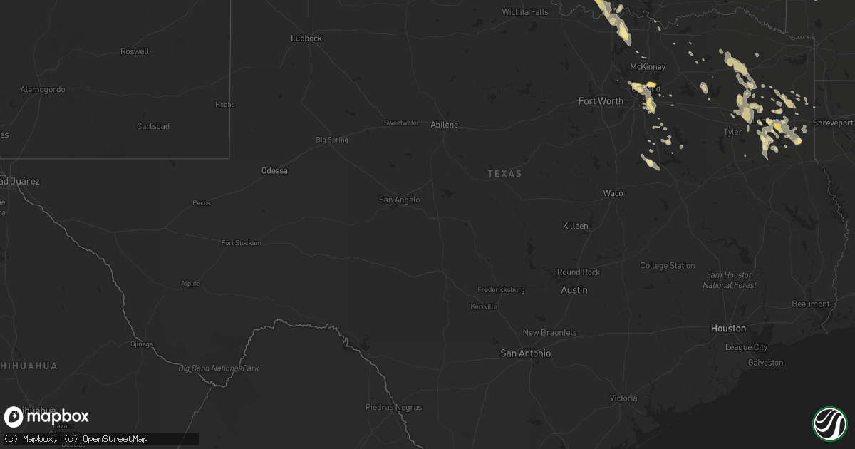
Hail Map in Texas on October 5, 2014
Get this storm
October 5 map
$229
one time, instant access
Download today. No call, no setup
Keep the $229
Bought the map and want the full workflow? Apply the entire $229 to a subscription within 7 days. None of it is wasted.
Every map, not just this one
This buys you this map. Subscription and you get every map we run, in the markets you choose from a few cities to whole states to nationwide. Plus real-time alerts the moment a storm fires.
Contact data
Name, contact info, occupancy, even credit band for addresses in the footprint. You go from where it hit to who to call.
Become the source they trust
Unlimited branding weather history reports on demand. You already have the documented answer ready for the property owner, and you are the one who showed up with it.
Property data and RoofTrace estimates
Pull up any address you have got, its value and the exact code rules for that jurisdiction, straight from One Click Code. Then RoofTrace estimates the squares, pitch, and roof value, priced the way you price.
Storm reports in Texas
Texas
| Date | Description |
|---|---|
| 10/05/20146:55 AM CDT | Numerous trees down across the county |
| 10/05/20146:29 AM CDT | Hail reported in henderson. |
| 10/05/20146:29 AM CDT | Several trees and power lines downed throughout the northern portion of the county. |
| 10/05/20146:28 AM CDT | Tree down just east of town near fm 248 and hall road. |
| 10/05/20146:12 AM CDT | Pingpong ball sized hail reported just southeast of town. |
| 10/05/20146:12 AM CDT | Tree down west of kilgore. |
| 10/05/20145:44 AM CDT | Quarter sized hail was reported in rowlett via twitter |
| 10/05/20145:30 AM CDT | Quarter hail in rockwall. |
| 10/05/20145:15 AM CDT | Dime to quarter sized hail in southeast wylie. |
| 10/05/20145:15 AM CDT | Quarter size hail reported between newsome and pittsburg. |
| 10/05/20145:10 AM CDT | Numerous trees down |
| 10/05/20145:05 AM CDT | Reported in the southern portions of wylie per the fire dept |
| 10/05/20145:00 AM CDT | Quarter hail near the dallas/collin county border |
| 10/05/20144:45 AM CDT | Quarter size hail reported northeast of mount vernon. |
All States Impacted by Hail Map on October 5, 2014
Cities Impacted by Hail Map on October 5, 2014
- Trezevant, TN
- Atwood, TN
- Huntingdon, TN
- Beckville, TX
- Pottsville, AR
- Keota, OK
- Alba, TX
- Ennis, TX
- Scurry, TX
- Edmond, OK
- Sapulpa, OK
- Boley, OK
- Carney, OK
- Prague, OK
- Paden, OK
- Sparks, OK
- Tryon, OK
- Perkins, OK
- Chandler, OK
- Wellston, OK
- Meridian, OK
- Carthage, TX
- Lamar, MS
- Ashland, MS
- Michigan City, MS
- Emory, TX
- Kilgore, TX
- Porter, OK
- Sallisaw, OK
- Marshall, TX
- Whitesboro, TX
- Gainesville, TX
- Collinsville, TX
- Jennings, OK
- Boynton, OK
- Mounds, OK
- Mannford, OK
- Glenpool, OK
- Bristow, OK
- Kiefer, OK
- Okmulgee, OK
- Beggs, OK
- Bixby, OK
- Council Hill, OK
- Morris, OK
- Drumright, OK
- Kellyville, OK
- Clarksville, AR
- Purcell, OK
- Ringling, OK
- Ratliff City, OK
- Duncan, OK
- Loco, OK
- Gilmer, TX
- Red Banks, MS
- Holly Springs, MS
- Bokoshe, OK
- Purdon, TX
- Flower Mound, TX
- Webbers Falls, OK
- Hattieville, AR
- Cleveland, AR
- Richardson, TX
- Wylie, TX
- Rockwall, TX
- Plano, TX
- Sachse, TX
- Rowlett, TX
- Garland, TX
- Sunnyvale, TX
- Mesquite, TX
- Dallas, TX
- Seagoville, TX
- Balch Springs, TX
- Mammoth Spring, AR
- Hallsville, TX
- Harleton, TX
- Longview, TX
- Geary, OK
- Greenfield, OK
- Lone Grove, OK
- Ardmore, OK
- Wilson, OK
- Jefferson, TX
- Pittsburg, TX
- Graham, OK
- Burneyville, OK
- Healdton, OK
- Overbrook, OK
- Huntsville, AR
- Warner, OK
- Checotah, OK
- Watonga, OK
- Depew, OK
- Marietta, OK
- Lookeba, OK
- Hinton, OK
- Stigler, OK
- Henderson, TX
- Lindsay, OK
- Tecumseh, OK
- Bee Branch, AR
- Overton, TX
- Saltillo, TX
- Addison, TX
- Lexington, OK
- Norman, OK
- Springer, OK
- Dierks, AR
- Sulphur Bluff, TX
- Mount Vernon, TX
- Piedmont, OK
- Okarche, OK
- Gracemont, OK
- Anadarko, OK
- Binger, OK
- Cove, AR
- Guthrie, OK
- Bonham, TX
- Bradford, AR
- Elmore City, OK
- Bradley, OK
- Marlow, OK
- Foster, OK
- Rush Springs, OK
- Byhalia, MS
- Ladonia, TX
- Wolfe City, TX
- Pocahontas, AR
- Arkoma, OK
- Forney, TX
- Carrollton, TX
- Norcatur, KS
- Tyler, TX
- Winona, TX
- Avinger, TX
- Fort Smith, AR
- Calumet, OK
- Luther, OK
- Talco, TX
- Mount Pleasant, TX
- Dike, TX
- Winfield, TX
- Tatum, TX
- Russellville, AR
- London, AR
- Dover, AR
- Gleason, TN
- Celina, TX
- Mckinney, TX
- Oklahoma City, OK
- Tussy, OK
- Kerens, TX
- Rice, TX
- Porum, OK
- Diana, TX
- Karnack, TX
- Mooringsport, LA
- Oktaha, OK
- Muskogee, OK
- Haskell, OK
- Lone Star, TX
- Daingerfield, TX
- De Queen, AR
- El Reno, OK
- Hennepin, OK
- Henryetta, OK
- Lindale, TX
- Macomb, OK
- Mcloud, OK
- Shawnee, OK
- Newalla, OK
- Corsicana, TX
- Barry, TX
- Danville, AR
- Belleville, AR
- Yukon, OK
- Trinidad, TX
- Big Sandy, TX
- Gladewater, TX
- Ravenden, AR
- Thayer, MO
- Ozark, AR
- Clinton, AR
- Rector, AR
- Marmaduke, AR
- Morrilton, AR
- Seminole, OK
- Savannah, TN
- Mount Enterprise, TX
- Long Branch, TX
- Chickasha, OK
- Winnsboro, TX
- Leesburg, TX
- Scroggins, TX
- Hawkins, TX
- Maysville, OK
- Blanchard, OK
- Thackerville, OK
- Davis, OK
- Alex, OK
- Ninnekah, OK
- Tioga, TX
- Chatfield, TX
- Kemp, TX
- De Berry, TX
- Waskom, TX
- Terrell, TX
- Princeton, KY
- Dawson Springs, KY
- Bruceton, TN
- Buena Vista, TN
- Mena, AR
- Brashear, TX
- Point, TX
- Cecil, AR
- Mannsville, OK
- Laneville, TX
- Sulphur Springs, TX
- Wortham, TX
- Blooming Grove, TX
- Dawson, TX
- Richland, TX
- Harrah, OK
- Jones, OK
- Potts Camp, MS
- Hernando, MS
- Middleton, TN
- Pocahontas, TN
- Dustin, OK
- Sherwood, AR
- Lafe, AR
- Little Rock, AR
- Umpire, AR
- Lewisburg, KY
- Greenville, KY
- Elkton, KY
- Roland, AR
- Falkner, MS
- Walnut, MS
- Holdenville, OK
- Springville, TN
- Paris, TN
- Noble, OK
- Ola, AR
- Meeker, OK
- Mansfield, TN
- Milan, TN
- Hartman, AR
- Wewoka, OK
- Peach Orchard, AR
- Delaplaine, AR
- Knoxville, AR
- Lamar, AR
- Arcadia, OK
- Scotland, AR
- Kingfisher, OK
- Washington, OK
- Hennessey, OK
- Cashion, OK
- Stroud, OK
- Hagarville, AR
- Center Ridge, AR
- Hector, AR
- Choctaw, OK
- Bells, TX
- Denison, TX
- Troup, TX
- Camden, TN
- Hollow Rock, TN
- Poteau, OK
- Honey Grove, TX
- Biggers, AR
- Crofton, KY
- Lake Creek, TX
- Weleetka, OK
- Ivanhoe, TX
- Pelsor, AR
- Wesley, AR
- Konawa, OK
- Asher, OK
- Colbert, OK
- Okemah, OK
- Klondike, TX
- Earlsboro, OK
- Wayne, OK
- Pauls Valley, OK
- Paoli, OK
- Minco, OK
- Union City, OK
- Davenport, OK


