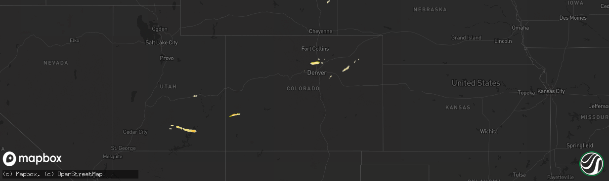
Hail Map in Colorado on October 1, 2022
The weather event in Colorado on October 1, 2022 includes Hail map. 4 states and 30 cities were impacted and suffered possible damage. The total estimated number of properties impacted is 18,274.
Want more than just the map?
Turn this storm into a full workflow.
- Owner + property data so you know who to knock
- OnDemand branded weather history reports to win the "did we even have hail?" argument
- RoofTrace estimate so reps stop guessing numbers at the door
Bought this map? Upgrade within 7 days and we'll credit the $230. (10-15 min setup call)
Hail
18,274
Estimated number of impacted properties by a 1.00" hail or larger0
Estimated number of impacted properties by a 1.75" hail or larger0
Estimated number of impacted properties by a 2.50" hail or largerStorm reports in Colorado
Colorado
| Date | Description |
|---|---|
| 10/01/20226:07 PM CDT | A local report indicates 1.50 inch wind near NUCLA |
| 10/01/20224:54 PM CDT | A local report indicates 1.50 inch wind near 1 NNE ERIE |
| 10/01/20224:51 PM CDT | A local report indicates 1.00 inch wind near 3 N ERIE |
| 10/01/20224:50 PM CDT | Report from mping: quarter |
| 10/01/20224:47 PM CDT | Report from mping: quarter |
| 10/01/20223:16 AM CDT | At 814 PM MDT, a severe thunderstorm was located 8 miles south of Lodgepole, or 9 miles southwest of Chappell, moving north at 35 mph. HAZARD...70 mph wind gusts. SOURCE...Public. At 815 PM MDT, a wind gust to 69 mph was recorded 7 miles west of Sedwick Colorado. IMPACT...Expect considerable tree damage. Damage is likely to mobile homes, roofs, and outbuildings. Locations impacted include... Chappell and Mount Vernon. This includes Interstate 80 in Nebraska between mile markers 79 and94. |
| 10/01/202212:29 AM CDT | At 528 PM MDT, a severe thunderstorm was located 11 miles north of Norwood, moving east at 25 mph. HAZARD...60 mph wind gusts and quarter size hail. SOURCE...Radar indicated. IMPACT...Hail damage to vehicles is expected. Expect wind damage to roofs, siding, and trees. This severe thunderstorm will remain over mainly rural areas of northwestern Ouray and south central Montrose Counties. |
| 09/30/202211:58 PM CDT | At 457 PM MDT, a severe thunderstorm was located over Nucla, moving east at 20 mph. HAZARD...60 mph wind gusts and half dollar size hail. SOURCE...Radar indicated. IMPACT...Hail damage to vehicles is expected. Expect wind damage to roofs, siding, and trees. This severe thunderstorm will remain over mainly rural areas of south central Montrose County, including the following locations... Vancorum. This includes the following highways... Colorado 90 near mile marker 33. Colorado 141 between mile markers 56 and 65. Colorado 145 between mile markers 115 and 116. |
| 09/30/202211:34 PM CDT | At 434 PM MDT, a severe thunderstorm was located 8 miles west of Naturita, moving northeast at 25 mph. HAZARD...60 mph wind gusts and quarter size hail. SOURCE...Radar indicated. IMPACT...Hail damage to vehicles is expected. Expect wind damage to roofs, siding, and trees. This severe thunderstorm will be near... Naturita around 450 PM MDT.Other locations in the path of this severe thunderstorm includeNucla. This includes the following highways... Colorado 90 between mile markers 21 and 33. Colorado 141 between mile markers 61 and 73. |
| 09/30/202210:54 PM CDT | At 354 PM MDT, a severe thunderstorm was located near Erie, or 23 miles north of Denver, moving east at 25 mph. HAZARD...Ping pong ball size hail. SOURCE...Radar indicated. IMPACT...People and animals outdoors will be injured. Expect damage to roofs, siding, windows, and vehicles. This severe thunderstorm will be near... Firestone, Frederick and Dacono around 405 PM MDT.Other locations in the path of this severe thunderstorm include FortLupton and Lochbuie. |
| 09/30/20227:42 PM CDT | A local report indicates 62 MPH wind near 1 N AKRON |
Cities Impacted by Hail Map on October 1, 2022
- Hudson, CO
- Boulder, UT
- Naturita, CO
- Nucla, CO
- Bedrock, CO
- Dacono, CO
- Brighton, CO
- Lafayette, CO
- Longmont, CO
- Erie, CO
- Fort Lupton, CO
- Boulder, CO
- Akron, CO
- Green River, UT
- Platteville, CO
- Woodrow, CO
- Fort Morgan, CO
- Lake Powell, UT
- Hanksville, UT
- Escalante, UT
- Chino Valley, AZ
- Strasburg, CO
- Lingle, WY
- Yoder, WY
- Fort Laramie, WY
- Deer Trail, CO
- Central City, CO
- Bennett, CO
- Firestone, CO
- Frederick, CO


