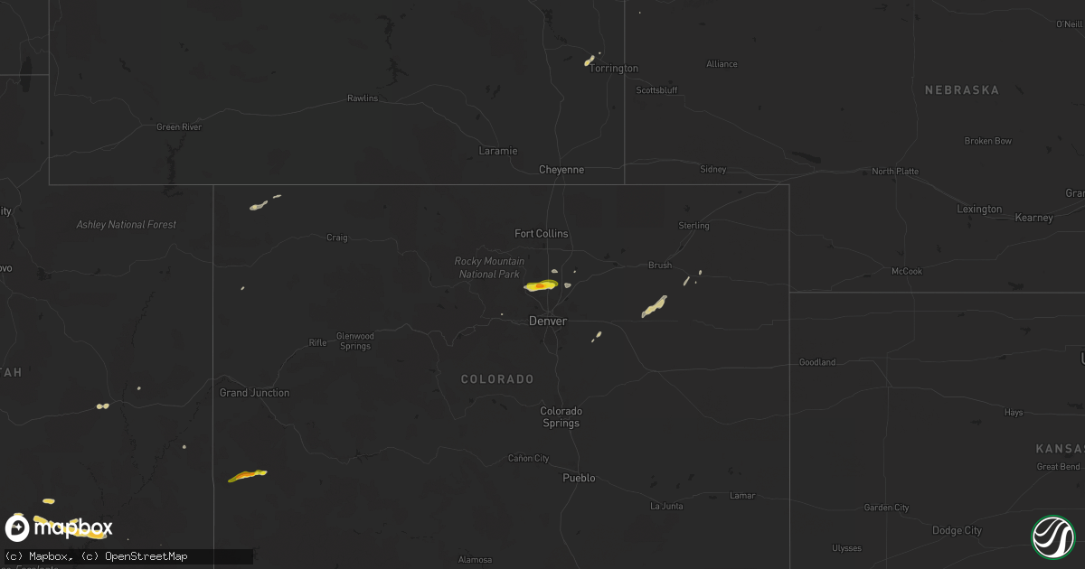
Hail Map on October 1, 2022
Get this storm
October 1 map
$229
one time, instant access
Download today. No call, no setup
Keep the $229
Bought the map and want the full workflow? Apply the entire $229 to a subscription within 7 days. None of it is wasted.
Every map, not just this one
This buys you this map. Subscription and you get every map we run, in the markets you choose from a few cities to whole states to nationwide. Plus real-time alerts the moment a storm fires.
Contact data
Name, contact info, occupancy, even credit band for addresses in the footprint. You go from where it hit to who to call.
Become the source they trust
Unlimited branding weather history reports on demand. You already have the documented answer ready for the property owner, and you are the one who showed up with it.
Property data and RoofTrace estimates
Pull up any address you have got, its value and the exact code rules for that jurisdiction, straight from One Click Code. Then RoofTrace estimates the squares, pitch, and roof value, priced the way you price.
Storm reports
Utah
| Date | Description |
|---|---|
| 10/01/20222:29 AM CDT | At 729 PM MDT, a severe thunderstorm was located near Fry Canyon, or 39 miles northwest of Mexican Hat, moving east at 25 mph. HAZARD...60 mph wind gusts and penny size hail. SOURCE...Radar indicated. IMPACT...Expect damage to roofs, siding, and trees. This severe thunderstorm will be near... Fry Canyon around 740 PM MDT. This includes Utah 95 between mile markers 61 and 86. |
| 10/01/20222:06 AM CDT | At 705 PM MDT, a severe thunderstorm was located 12 miles east of Ticaboo, moving east at 20 mph. HAZARD...60 mph wind gusts and quarter size hail. SOURCE...Radar indicated. IMPACT...Hail damage to vehicles is expected. Expect wind damage to roofs, siding, and trees. This severe thunderstorm will remain over mainly rural areas of west central San Juan County. This includes Utah 95 between mile markers 62 and 74. |
| 10/01/20221:44 AM CDT | At 644 PM MDT, a severe thunderstorm was located near Ticaboo, or 45 miles southeast of Capitol Reef National Park, moving east at 20 mph. HAZARD...60 mph wind gusts and quarter size hail. SOURCE...Radar indicated. IMPACT...Hail damage to vehicles is expected. Expect wind damage to roofs, siding, and trees. Locations impacted include... Ticaboo and Glen Canyon National Recreation Area. This includes the following highways... Utah Route 95 between mile markers 51 and 54. Utah Route 276 between mile markers 8 and 29, and near mile marker32. |
| 10/01/20221:41 AM CDT | At 640 AM MDT, a severe thunderstorm was located near Sunnyside, or 26 miles east of Price, moving east at 40 mph. Trained spotters reported nickel size hail in Sunnyside and the storm has since intensified. HAZARD...Quarter size hail. SOURCE...Radar indicated. IMPACT...Damage to vehicles is expected. Locations impacted include... Sunnyside and East Carbon. |
| 10/01/20221:17 AM CDT | At 617 PM MDT, severe thunderstorms were located along a line extending from 9 miles southwest of Hite Marina to 14 miles northwest of Ticaboo, moving east at 20 mph. HAZARD...60 mph wind gusts and quarter size hail. SOURCE...Radar indicated. IMPACT...Hail damage to vehicles is expected. Expect wind damage to roofs, siding, and trees. Locations impacted include... Ticaboo, Hite Marina and Glen Canyon National Recreation Area. This includes the following highways... Utah Route 95 between mile markers 36 and 54. Utah Route 276 between mile markers 6 and 34. |
| 10/01/202212:44 AM CDT | At 544 PM MDT, a severe thunderstorm was located 23 miles northwest of Ticaboo, or over the south end of Capitol Reef National Park, moving east at 20 mph. HAZARD...60 mph wind gusts and quarter size hail. SOURCE...Radar indicated. IMPACT...Hail damage to vehicles is expected. Expect wind damage to roofs, siding, and trees. This severe thunderstorm will remain over mainly rural areas of south central Garfield County. |
| 10/01/202212:12 AM CDT | At 511 AM MDT, a severe thunderstorm was located 12 miles southeast of Sunnyside, or 31 miles north of Green River, moving east at 40 mph. HAZARD...Quarter size hail. SOURCE...Radar indicated. IMPACT...Damage to vehicles is expected. This severe thunderstorm will remain over mainly rural areas of northeastern Emery and southeastern Carbon Counties. |
| 10/01/202212:12 AM CDT | At 512 PM MDT, severe thunderstorms were located along a line extending from 9 miles east of Boulder to 11 miles northwest of Ticaboo, moving east at 10 mph. HAZARD...60 mph wind gusts and quarter size hail. SOURCE...Radar indicated. IMPACT...Hail damage to vehicles is expected. Expect wind damage to roofs, siding, and trees. Locations impacted include... Capitol Reef National Park and Boulder. This includes the following highways... Utah Route 12 between mile markers 91 and 99. Utah Route 276 between mile markers 17 and 24. |
| 09/30/202211:51 PM CDT | At 450 AM MDT, a severe thunderstorm was located 9 miles south of Sunnyside, or 21 miles southeast of Price, moving east at 40 mph. HAZARD...Ping pong ball size hail and 60 mph wind gusts. SOURCE...Radar indicated. IMPACT...People and animals outdoors will be injured. Expect hail damage to roofs, siding, windows, and vehicles. Expect wind damage to roofs, siding, and trees. Locations impacted include... East Carbon.This includes US Route 6 between mile markers 259 and 274. |
| 09/30/202211:46 PM CDT | At 446 PM MDT, a severe thunderstorm was located 17 miles southeast of Capitol Reef National Park, moving east at 10 mph. HAZARD...60 mph wind gusts and quarter size hail. SOURCE...Radar indicated. IMPACT...Hail damage to vehicles is expected. Expect wind damage to roofs, siding, and trees. This severe thunderstorm will remain over mainly rural areas of north central Garfield County. |
| 09/30/202211:23 PM CDT | At 422 PM MDT, a severe thunderstorm was located over Boulder, or 13 miles northeast of Escalante, moving east at 10 mph. HAZARD...60 mph wind gusts and quarter size hail. SOURCE...Radar indicated. IMPACT...Hail damage to vehicles is expected. Expect wind damage to roofs, siding, and trees. Locations impacted include... Boulder.This includes Utah Route 12 between mile markers 75 and 92. |
| 09/30/202211:21 PM CDT | At 421 PM MDT, a severe thunderstorm was located 13 miles southeast of Capitol Reef National Park, moving east at 5 mph. HAZARD...60 mph wind gusts and quarter size hail. SOURCE...Radar indicated. IMPACT...Hail damage to vehicles is expected. Expect wind damage to roofs, siding, and trees. Locations impacted include... Capitol Reef National Park. |
Colorado
| Date | Description |
|---|---|
| 10/01/20226:07 PM CDT | A local report indicates 1.50 inch wind near NUCLA |
| 10/01/20224:54 PM CDT | A local report indicates 1.50 inch wind near 1 NNE ERIE |
| 10/01/20224:51 PM CDT | A local report indicates 1.00 inch wind near 3 N ERIE |
| 10/01/20224:50 PM CDT | Report from mping: quarter |
| 10/01/20224:47 PM CDT | Report from mping: quarter |
| 10/01/20223:16 AM CDT | At 814 PM MDT, a severe thunderstorm was located 8 miles south of Lodgepole, or 9 miles southwest of Chappell, moving north at 35 mph. HAZARD...70 mph wind gusts. SOURCE...Public. At 815 PM MDT, a wind gust to 69 mph was recorded 7 miles west of Sedwick Colorado. IMPACT...Expect considerable tree damage. Damage is likely to mobile homes, roofs, and outbuildings. Locations impacted include... Chappell and Mount Vernon. This includes Interstate 80 in Nebraska between mile markers 79 and94. |
| 10/01/202212:29 AM CDT | At 528 PM MDT, a severe thunderstorm was located 11 miles north of Norwood, moving east at 25 mph. HAZARD...60 mph wind gusts and quarter size hail. SOURCE...Radar indicated. IMPACT...Hail damage to vehicles is expected. Expect wind damage to roofs, siding, and trees. This severe thunderstorm will remain over mainly rural areas of northwestern Ouray and south central Montrose Counties. |
| 09/30/202211:58 PM CDT | At 457 PM MDT, a severe thunderstorm was located over Nucla, moving east at 20 mph. HAZARD...60 mph wind gusts and half dollar size hail. SOURCE...Radar indicated. IMPACT...Hail damage to vehicles is expected. Expect wind damage to roofs, siding, and trees. This severe thunderstorm will remain over mainly rural areas of south central Montrose County, including the following locations... Vancorum. This includes the following highways... Colorado 90 near mile marker 33. Colorado 141 between mile markers 56 and 65. Colorado 145 between mile markers 115 and 116. |
| 09/30/202211:34 PM CDT | At 434 PM MDT, a severe thunderstorm was located 8 miles west of Naturita, moving northeast at 25 mph. HAZARD...60 mph wind gusts and quarter size hail. SOURCE...Radar indicated. IMPACT...Hail damage to vehicles is expected. Expect wind damage to roofs, siding, and trees. This severe thunderstorm will be near... Naturita around 450 PM MDT.Other locations in the path of this severe thunderstorm includeNucla. This includes the following highways... Colorado 90 between mile markers 21 and 33. Colorado 141 between mile markers 61 and 73. |
| 09/30/202210:54 PM CDT | At 354 PM MDT, a severe thunderstorm was located near Erie, or 23 miles north of Denver, moving east at 25 mph. HAZARD...Ping pong ball size hail. SOURCE...Radar indicated. IMPACT...People and animals outdoors will be injured. Expect damage to roofs, siding, windows, and vehicles. This severe thunderstorm will be near... Firestone, Frederick and Dacono around 405 PM MDT.Other locations in the path of this severe thunderstorm include FortLupton and Lochbuie. |
| 09/30/20227:42 PM CDT | A local report indicates 62 MPH wind near 1 N AKRON |
Nebraska
| Date | Description |
|---|---|
| 09/30/20229:49 PM CDT | Home weather station record 61 mph wind gust. |
Cities Impacted by Hail Map on October 1, 2022
- Hudson, CO
- Boulder, UT
- Naturita, CO
- Nucla, CO
- Bedrock, CO
- Dacono, CO
- Brighton, CO
- Lafayette, CO
- Longmont, CO
- Erie, CO
- Fort Lupton, CO
- Boulder, CO
- Akron, CO
- Green River, UT
- Platteville, CO
- Woodrow, CO
- Fort Morgan, CO
- Lake Powell, UT
- Hanksville, UT
- Escalante, UT
- Chino Valley, AZ
- Strasburg, CO
- Lingle, WY
- Yoder, WY
- Fort Laramie, WY
- Deer Trail, CO
- Central City, CO
- Bennett, CO
- Firestone, CO
- Frederick, CO