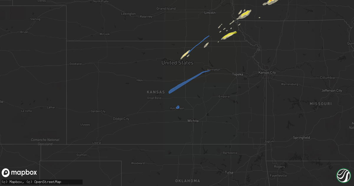
Hail Map in Kansas on October 1, 2019
Get this storm
October 1 map
$229
one time, instant access
Download today. No call, no setup
Keep the $229
Bought the map and want the full workflow? Apply the entire $229 to a subscription within 7 days. None of it is wasted.
Every map, not just this one
This buys you this map. Subscription and you get every map we run, in the markets you choose from a few cities to whole states to nationwide. Plus real-time alerts the moment a storm fires.
Contact data
Name, contact info, occupancy, even credit band for addresses in the footprint. You go from where it hit to who to call.
Become the source they trust
Unlimited branding weather history reports on demand. You already have the documented answer ready for the property owner, and you are the one who showed up with it.
Property data and RoofTrace estimates
Pull up any address you have got, its value and the exact code rules for that jurisdiction, straight from One Click Code. Then RoofTrace estimates the squares, pitch, and roof value, priced the way you price.
Storm reports in Kansas
Kansas
| Date | Description |
|---|---|
| 10/01/20195:54 PM CDT | 70 mph wind gust estimate. |
| 10/01/20195:45 PM CDT | Tree limbs broken. |
| 10/01/20194:53 PM CDT | A local report indicates 60 MPH wind near 6 ENE INMAN |
| 10/01/20194:53 PM CDT | Peak wind gust at the salina municipal airport. |
| 10/01/20194:33 PM CDT | A local report indicates 58 MPH wind near 1 E HUTCHINSON AIRPORT |
| 10/01/20194:32 PM CDT | A local report indicates 60 MPH wind near 2 NW HUTCHINSON |
| 10/01/20194:31 PM CDT | Peak wind gust at the hutchinson municipal airport. |
| 10/01/20192:55 PM CDT | Delayed report... Roof off building on south edge of town. Tree and large branch damage. Time estimated by radar. |
| 10/01/201912:31 AM CDT | At 531 PM CDT, a severe thunderstorm was located near Durham, or near Hillsboro, moving northeast at 35 mph. HAZARD...60 mph wind gusts. SOURCE...Radar indicated. IMPACT...Expect damage to roofs, siding, and trees. Locations impacted include... Hillsboro, Lincolnville, Ramona, Tampa, Lost Springs, Pilsen and Marion Lake. |
| 09/30/201911:58 PM CDT | At 457 PM CDT, a severe thunderstorm was located near Salina, moving northeast at 35 mph. HAZARD...60 mph wind gusts. SOURCE...Automated weather stations. A wind gust of 60 mph was reported in Salina at 4:55pm. IMPACT...Expect damage to roofs, siding, and trees. This severe thunderstorm will be near... Niles around 515 PM CDT. Solomon around 525 PM CDT. Abilene and Manchester around 535 PM CDT. Talmage around 540 PM CDT. Moonlight around 545 PM CDT.This includes Interstate 70 between mile markers 267 and 284. |
| 09/30/201911:47 PM CDT | At 447 PM CDT, a severe thunderstorm was located 4 miles south of Summerfield, moving northeast at 55 mph. HAZARD...60 mph wind gusts and penny size hail. SOURCE...Radar indicated. IMPACT...Expect damage to roofs, siding, and trees. Locations impacted include... Axtell, Beattie and Summerfield. |
| 09/30/201911:43 PM CDT | At 442 PM CDT, a severe thunderstorm was located near Smolan, or near Salina, moving northeast at 60 mph. HAZARD...60 mph wind gusts. SOURCE...Radar indicated. IMPACT...Expect damage to roofs, siding, and trees. Locations impacted include... Salina, Smolan, New Cambria, Falun, Kipp and Salina Airport. This includes the following highways... Interstate 135 between Mile Markers 84 and 95. Interstate 70 between Mile Markers 243 and 266. |
| 09/30/201911:32 PM CDT | At 432 PM CDT, a severe thunderstorm was located near Hutchinson, moving northeast at 50 mph. HAZARD...60 mph wind gusts. SOURCE...Trained weather spotters. IMPACT...Expect damage to roofs, siding, and trees. Locations impacted include... Hutchinson, Mcpherson, Hesston, Hillsboro, South Hutchinson, Marion, Moundridge, Inman, Buhler, Burrton, Galva, Canton, Florence, Goessel, Lehigh, Durham, Tampa, Roxbury, Marion Lake and Hutchinson Airport.This includes Interstate 135 between Mile Markers 38 and 61. |
| 09/30/20199:38 PM CDT | At 237 PM CDT, a severe thunderstorm was located 5 miles northeast of Concordia, moving northeast at 55 mph. HAZARD...60 mph wind gusts and quarter size hail. SOURCE...Radar indicated. IMPACT...Hail damage to vehicles is expected. Expect wind damage to roofs, siding, and trees. Locations impacted include... Cuba, Haddam, Narka, Mahaska and Agenda. |
All States Impacted by Hail Map on October 1, 2019
Cities Impacted by Hail Map on October 1, 2019
- Boscobel, WI
- Postville, IA
- Calmar, IA
- Ossian, IA
- Waterville, IA
- Decorah, IA
- Waukon, IA
- Steuben, WI
- Harpers Ferry, IA
- Gays Mills, WI
- Dorchester, IA
- Eastman, WI
- Ferryville, WI
- Lansing, IA
- De Soto, WI
- Epworth, IA
- Durango, IA
- Dubuque, IA
- Peosta, IA
- Edgerton, WI
- Norwalk, IA
- Des Moines, IA
- Cumming, IA
- West Des Moines, IA
- Mitchellville, IA
- Colfax, IA
- Prairie City, IA
- Cuba City, WI
- Hazel Green, WI
- Kieler, WI
- Newhall, IA
- Blairstown, IA
- Luzerne, IA
- Van Horne, IA
- Monroe, WI
- Monticello, WI
- Elizabeth, IL
- Stockton, IL
- Beaver Dam, WI
- Reeseville, WI
- Columbus, WI
- Ithaca, MI
- Stanton, MI
- Edmore, MI
- Six Lakes, MI
- Bedford, IA
- New Market, IA
- Cashton, WI
- Tecumseh, NE
- Steinauer, NE
- Brasher Falls, NY
- Massena, NY
- Norfolk, NY
- Belleville, KS
- Juneau, WI
- Riverdale, MI
- Sumner, MI
- Alma, MI
- Elwell, MI
- Waterloo, IA
- Essex, IA
- Hamburg, IA
- Riverton, IA
- Sidney, IA
- Shenandoah, IA
- Farragut, IA
- Vestaburg, MI
- Maquoketa, IA
- Cresco, IA
- Vinton, IA
- Palo, IA
- Shellsburg, IA
- West Stockholm, NY
- Potsdam, NY
- Norwood, NY
- Milton, WI
- Cambridge, WI
- Janesville, WI
- Brooklyn, WI
- Fort Atkinson, WI
- Palmyra, WI
- Mukwonago, WI
- Eagle, WI
- Dousman, WI
- Albany, WI
- Jefferson, WI
- Whitewater, WI
- Stoughton, WI
- East Troy, WI
- Evansville, WI
- Jal, NM
- Randolph, IA
- Reedsburg, WI
- Table Rock, NE
- Pawnee City, NE
- Humboldt, NE
- Stella, NE
- Kendall, WI
- Wilton, WI
- Adell, WI
- Runnells, IA
- Newton, IA
- Hartford, IA
- Carlisle, IA
- Auburn, NE
- Mayville, WI
- Monticello, IA
- Hopkinton, IA
- Pleasant Hill, IA
- Altoona, IA
- Stoddard, WI
- Chaseburg, WI
- Coon Valley, WI
- Concordia, KS
- Orient, IA
- Prescott, IA
- Macksburg, IA
- Winterset, IA
- Creston, IA
- Greenfield, IA
- Kellogg, IA
- Prole, IA
- Van Meter, IA
- Windsor Heights, IA
- Clive, IA
- Wauzeka, WI
- Hanover, KS
- Mazomanie, WI
- Black Earth, WI
- Waunakee, WI
- Cross Plains, WI
- Dane, WI
- Middleton, WI
- Alburnett, IA
- Center Point, IA
- Marion, IA
- Toddville, IA
- Atkins, IA
- Keystone, IA
- Beattie, KS
- Kent, IL
- Savanna, IL
- Hanover, IL
- Laurel, IA
- Fort Atkinson, IA
- Fayette, IA
- Gilman, IA
- Tama, IA
- Howard City, MI
- Gowen, MI
- Coral, MI
- Grant, MI
- Fremont, MI
- Cedar Springs, MI
- Sidney, MI
- Greenville, MI
- Pierson, MI
- Trufant, MI
- Newaygo, MI
- Sand Lake, MI
- Waupun, WI
- Brandon, WI
- Markesan, WI
- Sauk City, WI
- Richland Center, WI
- Helena, NY
- West Bend, WI
- Lena, IL
- Pearl City, IL
- Bellevue, IA
- Mount Carroll, IL
- Burnett, WI
- Fox Lake, WI
- Randolph, WI
- Central City, IA
- Muscoda, WI
- Camp Douglas, WI
- Elroy, WI
- Green Bay, WI
- Agenda, KS
- Glasco, KS
- Twin Lake, MI
- Chase Mills, NY
- Monroe, IA
- Cedarville, IL
- Dakota, IL
- Freeport, IL
- Gotham, WI
- Lone Rock, WI
- Spring Green, WI
- Avoca, WI
- Blue River, WI
- Arena, WI
- Lewiston, NE
- South Wayne, WI
- Woodford, WI
- Browntown, WI
- Argyle, WI
- Gratiot, WI
- Horicon, WI
- Ontario, WI
- La Farge, WI
- Hillsboro, WI
- Bernard, IA
- Brownsville, WI
- Campbellsport, WI
- Lomira, WI
- Westby, WI
- Julian, NE
- Brock, NE
- Nebraska City, NE
- Lorimor, IA
- Bremen, KS
- Lynnville, IA
- Grinnell, IA
- Sully, IA
- Hudson, IA
- Johnston, IA
- Bridgeport, MI
- Brodhead, WI
- Footville, WI
- Elk Creek, NE
- Allenton, WI
- Hartford, WI
- Iron Ridge, WI
- Theresa, WI
- Afton, IA
- Fort Davis, TX
- Oakfield, WI
- Wadena, IA
- Corning, IA
- Rewey, WI
- Livingston, WI
- Platteville, WI
- Imogene, IA
- Peru, IA
- Waukee, IA
- Bevington, IA
- Martensdale, IA
- Cromwell, IA
- Booneville, IA
- Indianola, IA
- Saint Charles, IA
- Belmont, WI
- Sterling, NE
- Windsor, WI
- Deforest, WI
- Sun Prairie, WI
- Zwingle, IA
- Johnson, NE
- Edgewood, IA
- Manchester, IA
- Rock City, IL
- Malone, NY
- Oxford Junction, IA
- Baldwin, IA
- Lost Nation, IA
- Helenville, WI
- Marshall, WI
- Waucoma, IA
- Lawler, IA
- Burchard, NE
- Du Bois, NE
- Nemaha, NE
- Mauston, WI
- Norwalk, WI
- New Lisbon, WI
- Soldiers Grove, WI
- Mineral Point, WI
- East Dubuque, IL
- Rock Port, MO
- Watson, MO
- Ridgeway, IA
- Spragueville, IA
- Cascade, IA
- Farley, IA
- Loving, NM
- Viroqua, WI
- La Crosse, WI
- Frankenmuth, MI
- Clintonville, WI
- Cedar Falls, IA
- Dewar, IA
- Evansdale, IA
- Lakeview, MI
- Kewaskum, WI
- Fairwater, WI
- Washington, KS
- Morrowville, KS
- Diller, NE
- Blue Springs, NE
- Steele City, NE
- Cuba, KS
- Odell, NE
- Hollenberg, KS
- Haddam, KS
- Hutchinson, KS
- Marquette, KS
- Solomon, KS
- Junction City, KS
- Lindsborg, KS
- New Cambria, KS
- Falun, KS
- Milford, KS
- Lorraine, KS
- Riley, KS
- Brookville, KS
- Geneseo, KS
- Chapman, KS
- Salina, KS
- Abilene, KS
- Kanopolis, KS
- Ellsworth, KS
- Sullivan, WI
- Oconomowoc, WI
- Waukesha, WI
- Dunkerton, IA
- Reinbeck, IA
- Raymond, IA
- Jesup, IA
- Shubert, NE
- Vassar, MI
- Birch Run, MI
- Millington, MI
- Silverwood, MI
- Mayville, MI
- Fostoria, MI


