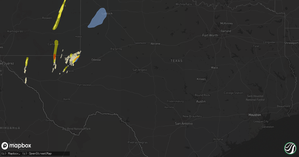
Hail Map in Texas on September 29, 2019
Get this storm
September 29 map
$229
one time, instant access
Download today. No call, no setup
Keep the $229
Bought the map and want the full workflow? Apply the entire $229 to a subscription within 7 days. None of it is wasted.
Every map, not just this one
This buys you this map. Subscription and you get every map we run, in the markets you choose from a few cities to whole states to nationwide. Plus real-time alerts the moment a storm fires.
Contact data
Name, contact info, occupancy, even credit band for addresses in the footprint. You go from where it hit to who to call.
Become the source they trust
Unlimited branding weather history reports on demand. You already have the documented answer ready for the property owner, and you are the one who showed up with it.
Property data and RoofTrace estimates
Pull up any address you have got, its value and the exact code rules for that jurisdiction, straight from One Click Code. Then RoofTrace estimates the squares, pitch, and roof value, priced the way you price.
Storm reports in Texas
Texas
| Date | Description |
|---|---|
| 09/29/20195:31 PM CDT | A local report indicates 66 MPH wind near 3 NW WINK |
| 09/29/20193:53 PM CDT | Along ranch road 652. |
| 09/29/20196:38 AM CDT | At 1138 PM CDT, severe thunderstorms were located along a line extending from 7 miles southeast of Whitharral to near Woodrow, moving northeast at 55 mph. HAZARD...70 mph wind gusts. SOURCE...Radar indicated. IMPACT...Expect considerable tree damage. Damage is likely to mobile homes, roofs, and outbuildings. Locations impacted include... Lubbock, Plainview, Slaton, Floydada, Abernathy, Hale Center, Shallowater, Idalou, Ralls, Lockney, Petersburg, Lorenzo, Anton, Ransom Canyon, Cotton Center, Spade, Dougherty, Aiken, Halfway and Cone. |
| 09/29/20196:07 AM CDT | At 1106 PM CDT, a severe thunderstorm was located 6 miles northwest of Brownfield, moving northeast at 40 mph. HAZARD...70 mph wind gusts. SOURCE...Radar indicated. IMPACT...Expect considerable tree damage. Damage is likely to mobile homes, roofs, and outbuildings. Locations impacted include... Lubbock, Levelland, Brownfield, Slaton, Wolfforth, Sundown, Ransom Canyon, Lubbock South Plains Mall, Texas Tech University, Locketville, Slide, Whitharral, Downtown Lubbock, Woodrow, Reese Center, Meadow, Smyer, Ropesville, New Home and Wellman. |
| 09/29/20191:21 AM CDT | At 620 PM CDT/520 PM MDT/, a severe thunderstorm was located 18 miles west of Jal, moving north at 20 mph. HAZARD...60 mph wind gusts and half dollar size hail. SOURCE...Radar indicated. IMPACT...Hail damage to vehicles is expected. Expect wind damage to roofs, siding, and trees. This severe thunderstorm will remain over mainly rural areas of southern Lea and northeastern Loving Counties. |
| 09/29/201912:36 AM CDT | At 535 PM MDT, a severe thunderstorm was located near Cornudas, moving north at 35 mph. HAZARD...60 mph wind gusts and half dollar size hail. SOURCE...Radar indicated. IMPACT...Hail damage to vehicles is expected. Expect wind damage to roofs, siding, and trees. Locations impacted include... Cornudas and Cornudas Mountains. |
| 09/28/201911:50 PM CDT | Measured by the west texas mesonet |
| 09/28/201911:30 PM CDT | At 429 PM MDT, a severe thunderstorm was located 4 miles west of Sierra Blanca, moving northeast at 25 mph. HAZARD...60 mph wind gusts and quarter size hail. SOURCE...Radar indicated. IMPACT...Hail damage to vehicles is expected. Expect wind damage to roofs, siding, and trees. Locations impacted include... Sierra Blanca, Interstate 10 west of Sierra Blanca, Sunset Ranches and Round Top Mountain. |
| 09/28/201911:25 PM CDT | Measured by the west texas mesonet |
| 09/28/201911:05 PM CDT | Measured by the west texas mesonet |
| 09/28/201910:51 PM CDT | At 351 PM CDT/251 PM MDT/, a severe thunderstorm was located 13 miles west of Red Bluff Reservoir, or 34 miles west of Mentone, moving north at 45 mph. HAZARD...60 mph wind gusts and quarter size hail. SOURCE...Radar indicated. IMPACT...Hail damage to vehicles is expected. Expect wind damage to roofs, siding, and trees. Locations impacted include... Loving, Malaga and Otis. |
| 09/28/201910:31 PM CDT | At 331 PM CDT, a severe thunderstorm was located 11 miles north of Toyah, moving north at 15 mph. HAZARD...60 mph wind gusts and quarter size hail. SOURCE...Radar indicated. IMPACT...Hail damage to vehicles is expected. Expect wind damage to roofs, siding, and trees. Locations impacted include... Mentone. |
| 09/28/20198:58 PM CDT | Measured at the winkler county airport. |
All States Impacted by Hail Map on September 29, 2019
Cities Impacted by Hail Map on September 29, 2019
- Le Mars, IA
- Kingsley, IA
- Remsen, IA
- Mansfield, IL
- White Heath, IL
- Seymour, IL
- Salt Flat, TX
- Dell City, TX
- Isabel, SD
- Trail City, SD
- McLaughlin, SD
- McIntosh, SD
- Meadow, SD
- Dupree, SD
- Timber Lake, SD
- Canton, IL
- Lewistown, IL
- Cuba, IL
- Saint Joseph, MN
- Sauk Rapids, MN
- Paynesville, MN
- Saint Cloud, MN
- Rice, MN
- Cold Spring, MN
- Sartell, MN
- Richmond, MN
- Foley, MN
- Van Horn, TX
- Beulah, WY
- Belle Fourche, SD
- Aladdin, WY
- Westport, SD
- Manito, IL
- Forest City, IL
- Roswell, NM
- Armington, IL
- Jal, NM
- Cerro Gordo, IL
- Decatur, IL
- Argenta, IL
- Delavan, IL
- Sierra Blanca, TX
- Morris, MN
- Portales, NM
- Floyd, NM
- Elida, NM
- Ipava, IL
- Smithfield, IL
- Valley City, ND
- Sundance, WY
- Pomeroy, IA
- Jolley, IA
- Wishek, ND
- Mentone, TX
- Newell, SD
- Gillette, WY
- Douglas, WY
- Newcastle, WY
- Upton, WY
- Kermit, TX
- Spearfish, SD
- Pecos, TX
- Pollock, SD
- Faith, SD
- Mud Butte, SD
- Ellisville, IL
- Mahomet, IL
- De Land, IL
- Champaign, IL
- Monticello, IL
- Weldon, IL
- Saint Joseph, IL
- Osakis, MN
- Cushing, MN
- Motley, MN
- Herreid, SD
- Wink, TX
- Prairie City, SD
- Lake Lillian, MN
- Manson, IA
- Nisland, SD
- Lowry, MN
- Leola, SD
- Topeka, IL
- Lead, SD
- Starbuck, MN
- Adair, IL
- Marietta, IL
- Green Valley, IL
- Table Grove, IL
- Liverpool, IL
- Bryant, IL
- Geneva, NE
- Wakpala, SD
- Monticello, MN
- Saint Michael, MN
- Pyote, TX
- Ipswich, SD
- Lidgerwood, ND
- Buffalo Lake, MN
- Fairfax, MN
- Gibbon, MN
- Hector, MN
- Hugo, MN
- Loving, NM
- Sidney, IL
- Maynard, MN
- Clara City, MN
- Pierz, MN
- Hillman, MN
- Lake Arthur, NM
- Fort Yates, ND
- Circleville, OH
- Ashville, OH
- Long Prairie, MN
- North Branch, MN
- Albertville, MN
- Elk River, MN
- Vale, SD
- Saint Onge, SD
- Alexandria, MN
- Raymond, MN
- McLean, IL
- Heyworth, IL
- Shirley, IL
- Caputa, SD
- New Underwood, SD
- Avon, MN
- Sunburg, MN
- Pennock, MN
- Hammond, IL
- Hecla, SD
- Columbia, SD
- Aberdeen, SD
- Frederick, SD
- Barnard, SD
- Buffalo, MN
- Andrews, TX
- Bement, IL
- Lehr, ND
- Franklin, MN
- Maple Lake, MN
- Annandale, MN
- Stanchfield, MN
- Rush City, MN
- Whitewood, SD
- Swanville, MN
- Farmer City, IL
- Arrowsmith, IL
- Stanford, IL
- Downs, IL
- Le Roy, IL
- Waynesville, IL
- Bloomington, IL
- Atlanta, IL
- Wapella, IL
- Bison, SD
- Hague, ND
- Havana, IL
- Gary, SD
- Circle Pines, MN
- Forest Lake, MN
- Roscoe, SD
- Cogswell, ND
- Lytton, IA
- Fonda, IA
- Bushnell, IL
- Avon, IL
- Newcastle, NE
- Andover, MN
- Macomb, IL
- Browerville, MN
- Norcross, MN
- Rogers, MN
- Hamel, MN
- Albany, MN
- Saint Francis, MN
- Zimmerman, MN
- Morgan, MN
- Madison, MN
- Bellingham, MN
- Onaka, SD
- Saint Paul, MN
- Minneapolis, MN
- Cayuga, ND
- Selby, SD
- Minneota, MN
- Orient, OH
- Williamsport, OH
- Stacy, MN
- Wyoming, MN
- Sturgis, SD
- Montpelier, ND
- Moorhead, MN
- Jud, ND
- Philo, IL
- Barnum, MN
- Moose Lake, MN
- Osage, WY
- Faulkton, SD
- Havana, ND
- Forman, ND
- Britton, SD
- Montevideo, MN
- Zeeland, ND
- Granite Falls, MN
- Bethel, MN
- Murdock, MN
- Emden, IL
- Hopedale, IL
- San Jose, IL
- Felton, MN
- Herman, MN
- Donnelly, MN
- Kerkhoven, MN
- Grey Eagle, MN
- Burtrum, MN
- Isle, MN
- Atwood, IL
- Strasburg, ND
- Brandt, SD
- Palmer, IA
- Stoutsville, OH
- Royalton, MN
- Tolono, IL
- Ivesdale, IL
- Fergus Falls, MN
- Owanka, SD
- Isanti, MN
- Stewart, MN
- Hutchinson, MN
- Ashley, ND
- Sauk Centre, MN
- Fort Hancock, TX
- Hermosa, SD
- Hankinson, ND
- Sac City, IA
- Dutch John, UT
- Vernal, UT
- New Plymouth, OH
- South Bloomingville, OH
- Logan, OH
- Rockbridge, OH
- Laurelville, OH
- Urbana, IL
- Fithian, IL
- Ogden, IL
- Carlsbad, NM
- Artesia, NM
- Hagerman, NM
- Clare, IA
- Wolfforth, TX
- Lubbock, TX
- Meadow, TX
- Plains, TX
- Smyer, TX
- Ropesville, TX
- Brownfield, TX
- Denver City, TX
- Levelland, TX
- Anton, TX
- Tahoka, TX
- Shallowater, TX
- Tokio, TX


