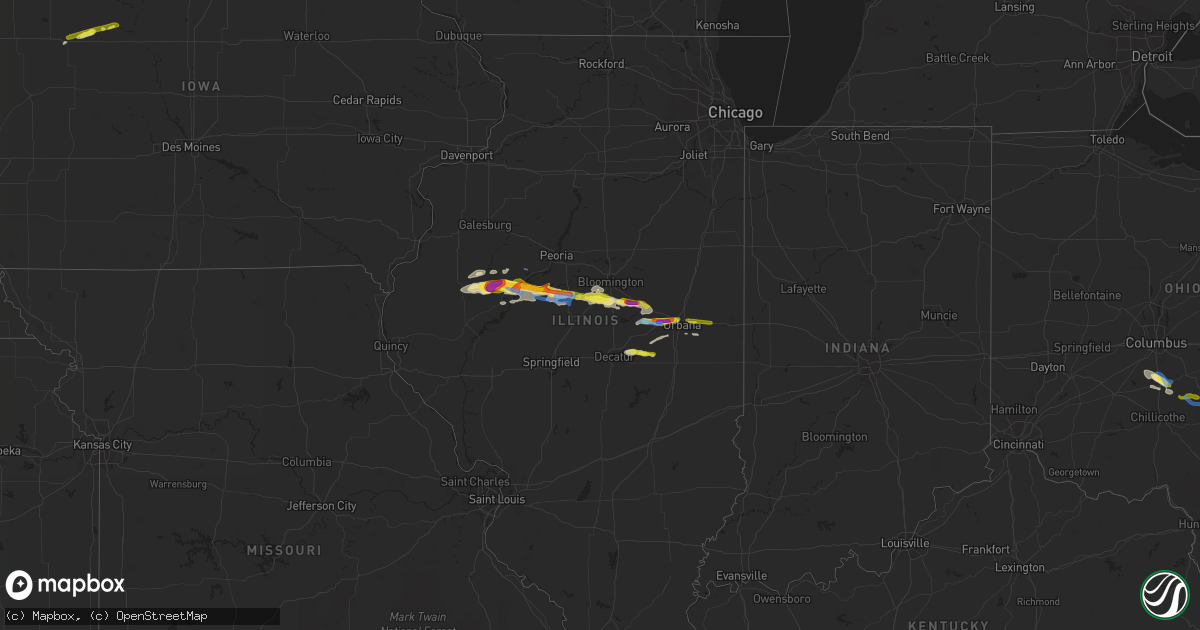
Hail Map in Illinois on September 29, 2019
Get this storm
September 29 map
$229
one time, instant access
Download today. No call, no setup
Keep the $229
Bought the map and want the full workflow? Apply the entire $229 to a subscription within 7 days. None of it is wasted.
Every map, not just this one
This buys you this map. Subscription and you get every map we run, in the markets you choose from a few cities to whole states to nationwide. Plus real-time alerts the moment a storm fires.
Contact data
Name, contact info, occupancy, even credit band for addresses in the footprint. You go from where it hit to who to call.
Become the source they trust
Unlimited branding weather history reports on demand. You already have the documented answer ready for the property owner, and you are the one who showed up with it.
Property data and RoofTrace estimates
Pull up any address you have got, its value and the exact code rules for that jurisdiction, straight from One Click Code. Then RoofTrace estimates the squares, pitch, and roof value, priced the way you price.
Storm reports in Illinois
Illinois
| Date | Description |
|---|---|
| 09/29/20195:40 PM CDT | A local report indicates 1.00 inch wind near 1 NW SEYMOUR |
| 09/29/20195:34 PM CDT | Mature pine trees snapped. |
| 09/29/20195:33 PM CDT | Trees and power lines downed. |
| 09/29/20195:30 PM CDT | Mature pine trees snapped. Crop damage from hail. |
| 09/29/20195:29 PM CDT | Trees and power lines downed. |
| 09/29/20195:02 PM CDT | Two large trees reported down. Time estimated by radar. |
| 09/29/20194:19 PM CDT | At 2228 county road 2400e... 8-12 inch diameter limbs blown down. Corn partially flattened. Delayed report. Time estimated from radar. |
| 09/29/20194:18 PM CDT | At 2365 locust road... One end of farm building is missing and tree limbs blown down. Delayed report. Time estimated from radar. |
| 09/29/20194:11 PM CDT | 611 pine street 3 inch diameter healty tree blown down on top of house at 607 pine st. At spruce and 7th street... A 8 inch diameter limb knocked power line off side of |
| 09/29/20193:57 PM CDT | Tree and power line damage reported in town. |
| 09/29/20193:50 PM CDT | Significant damage to crop fields on us 24 and old weaver road. Relayed by ema. |
| 09/29/20193:40 PM CDT | Numerous trees reported down on il-97. Relayed by ema. |
| 09/29/20193:15 PM CDT | A local report indicates 1.00 inch wind near N LEWISTOWN |
| 09/29/20193:10 PM CDT | A local report indicates 2.50 inch wind near 2 N LEWISTOWN |
| 09/29/20193:05 PM CDT | Time estimated by radar. |
| 09/29/20192:04 AM CDT | At 703 PM CDT, a severe thunderstorm was located near Oakley, or 7 miles east of Decatur, moving east at 25 mph. HAZARD...60 mph wind gusts and quarter size hail. SOURCE...Radar indicated. IMPACT...Hail damage to vehicles is expected. Expect wind damage to roofs, siding, and trees. Locations impacted include... Decatur, Bement, Cerro Gordo, Oakley and Milmine. This includes Interstate 72 near mile marker 150. |
| 09/29/201912:45 AM CDT | At 545 PM CDT, a severe thunderstorm was located near Le Roy, or 13 miles northeast of Clinton, moving east at 25 mph. HAZARD...60 mph wind gusts and quarter size hail. SOURCE...Radar indicated. IMPACT...Hail damage to vehicles is expected. Expect wind damage to roofs, siding, and trees. Locations impacted include... Le Roy, Farmer City, Bellflower and Foosland. This includes Interstate 74 between mile markers 151 and 163. |
| 09/29/201912:24 AM CDT | At 524 PM CDT, a severe thunderstorm was located near Seymour, or 9 miles west of Champaign, moving east at 30 mph. HAZARD...60 mph wind gusts and quarter size hail. SOURCE...Radar indicated. IMPACT...Hail damage to vehicles is expected. Expect wind damage to roofs, siding, and trees. Locations impacted include... Champaign, Urbana, Savoy, Mahomet, St. Joseph, Thomasboro, Ogden, Bondville, Lake Of The Woods, Seymour, Royal and Flatville.This includes the following highways... Interstate 57 between mile markers 231 and 247. Interstate 72 between mile markers 174 and 182. Interstate 74 between mile markers 169 and 197. |
| 09/29/201912:06 AM CDT | At 505 PM CDT, a severe thunderstorm was located near Waynesville, or 12 miles northwest of Clinton, moving east at 35 mph. HAZARD...60 mph wind gusts and quarter size hail. SOURCE...Radar indicated. IMPACT...Hail damage to vehicles is expected. Expect wind damage to roofs, siding, and trees. Locations impacted include... Le Roy, Heyworth, Farmer City, Downs, Wapella, Waynesville and Moraine View State Park.This includes the following highways... Interstate 55 between mile markers 147 and 153. Interstate 74 between mile markers 140 and 159. |
| 09/28/201911:55 PM CDT | At 455 PM CDT, a severe thunderstorm was located over Weldon, or 10 miles northwest of Monticello, moving east at 20 mph. HAZARD...60 mph wind gusts and penny size hail. SOURCE...Radar indicated. IMPACT...Expect damage to roofs, siding, and trees. Locations impacted include... Mansfield, De Land, Weldon, White Heath, De Witt, Galesville and Lodge.This includes the following highways... Interstate 72 between mile markers 168 and 173. Interstate 74 between mile markers 161 and 168. |
| 09/28/20199:42 PM CDT | At 242 PM CDT, a severe thunderstorm was located over Adair, or 11 miles east of Macomb, moving east at 20 mph. HAZARD...60 mph wind gusts. SOURCE...Radar indicated. IMPACT...Expect damage to roofs, siding, and trees. Locations impacted include... Bardolph, New Philadelphia, Adair and Pennington Point. |
| 09/28/20197:00 PM CDT | Mature pine trees snapped. |
All States Impacted by Hail Map on September 29, 2019
Cities Impacted by Hail Map on September 29, 2019
- Le Mars, IA
- Kingsley, IA
- Remsen, IA
- Mansfield, IL
- White Heath, IL
- Seymour, IL
- Salt Flat, TX
- Dell City, TX
- Isabel, SD
- Trail City, SD
- McLaughlin, SD
- McIntosh, SD
- Meadow, SD
- Dupree, SD
- Timber Lake, SD
- Canton, IL
- Lewistown, IL
- Cuba, IL
- Saint Joseph, MN
- Sauk Rapids, MN
- Paynesville, MN
- Saint Cloud, MN
- Rice, MN
- Cold Spring, MN
- Sartell, MN
- Richmond, MN
- Foley, MN
- Van Horn, TX
- Beulah, WY
- Belle Fourche, SD
- Aladdin, WY
- Westport, SD
- Manito, IL
- Forest City, IL
- Roswell, NM
- Armington, IL
- Jal, NM
- Cerro Gordo, IL
- Decatur, IL
- Argenta, IL
- Delavan, IL
- Sierra Blanca, TX
- Morris, MN
- Portales, NM
- Floyd, NM
- Elida, NM
- Ipava, IL
- Smithfield, IL
- Valley City, ND
- Sundance, WY
- Pomeroy, IA
- Jolley, IA
- Wishek, ND
- Mentone, TX
- Newell, SD
- Gillette, WY
- Douglas, WY
- Newcastle, WY
- Upton, WY
- Kermit, TX
- Spearfish, SD
- Pecos, TX
- Pollock, SD
- Faith, SD
- Mud Butte, SD
- Ellisville, IL
- Mahomet, IL
- De Land, IL
- Champaign, IL
- Monticello, IL
- Weldon, IL
- Saint Joseph, IL
- Osakis, MN
- Cushing, MN
- Motley, MN
- Herreid, SD
- Wink, TX
- Prairie City, SD
- Lake Lillian, MN
- Manson, IA
- Nisland, SD
- Lowry, MN
- Leola, SD
- Topeka, IL
- Lead, SD
- Starbuck, MN
- Adair, IL
- Marietta, IL
- Green Valley, IL
- Table Grove, IL
- Liverpool, IL
- Bryant, IL
- Geneva, NE
- Wakpala, SD
- Monticello, MN
- Saint Michael, MN
- Pyote, TX
- Ipswich, SD
- Lidgerwood, ND
- Buffalo Lake, MN
- Fairfax, MN
- Gibbon, MN
- Hector, MN
- Hugo, MN
- Loving, NM
- Sidney, IL
- Maynard, MN
- Clara City, MN
- Pierz, MN
- Hillman, MN
- Lake Arthur, NM
- Fort Yates, ND
- Circleville, OH
- Ashville, OH
- Long Prairie, MN
- North Branch, MN
- Albertville, MN
- Elk River, MN
- Vale, SD
- Saint Onge, SD
- Alexandria, MN
- Raymond, MN
- McLean, IL
- Heyworth, IL
- Shirley, IL
- Caputa, SD
- New Underwood, SD
- Avon, MN
- Sunburg, MN
- Pennock, MN
- Hammond, IL
- Hecla, SD
- Columbia, SD
- Aberdeen, SD
- Frederick, SD
- Barnard, SD
- Buffalo, MN
- Andrews, TX
- Bement, IL
- Lehr, ND
- Franklin, MN
- Maple Lake, MN
- Annandale, MN
- Stanchfield, MN
- Rush City, MN
- Whitewood, SD
- Swanville, MN
- Farmer City, IL
- Arrowsmith, IL
- Stanford, IL
- Downs, IL
- Le Roy, IL
- Waynesville, IL
- Bloomington, IL
- Atlanta, IL
- Wapella, IL
- Bison, SD
- Hague, ND
- Havana, IL
- Gary, SD
- Circle Pines, MN
- Forest Lake, MN
- Roscoe, SD
- Cogswell, ND
- Lytton, IA
- Fonda, IA
- Bushnell, IL
- Avon, IL
- Newcastle, NE
- Andover, MN
- Macomb, IL
- Browerville, MN
- Norcross, MN
- Rogers, MN
- Hamel, MN
- Albany, MN
- Saint Francis, MN
- Zimmerman, MN
- Morgan, MN
- Madison, MN
- Bellingham, MN
- Onaka, SD
- Saint Paul, MN
- Minneapolis, MN
- Cayuga, ND
- Selby, SD
- Minneota, MN
- Orient, OH
- Williamsport, OH
- Stacy, MN
- Wyoming, MN
- Sturgis, SD
- Montpelier, ND
- Moorhead, MN
- Jud, ND
- Philo, IL
- Barnum, MN
- Moose Lake, MN
- Osage, WY
- Faulkton, SD
- Havana, ND
- Forman, ND
- Britton, SD
- Montevideo, MN
- Zeeland, ND
- Granite Falls, MN
- Bethel, MN
- Murdock, MN
- Emden, IL
- Hopedale, IL
- San Jose, IL
- Felton, MN
- Herman, MN
- Donnelly, MN
- Kerkhoven, MN
- Grey Eagle, MN
- Burtrum, MN
- Isle, MN
- Atwood, IL
- Strasburg, ND
- Brandt, SD
- Palmer, IA
- Stoutsville, OH
- Royalton, MN
- Tolono, IL
- Ivesdale, IL
- Fergus Falls, MN
- Owanka, SD
- Isanti, MN
- Stewart, MN
- Hutchinson, MN
- Ashley, ND
- Sauk Centre, MN
- Fort Hancock, TX
- Hermosa, SD
- Hankinson, ND
- Sac City, IA
- Dutch John, UT
- Vernal, UT
- New Plymouth, OH
- South Bloomingville, OH
- Logan, OH
- Rockbridge, OH
- Laurelville, OH
- Urbana, IL
- Fithian, IL
- Ogden, IL
- Carlsbad, NM
- Artesia, NM
- Hagerman, NM
- Clare, IA
- Wolfforth, TX
- Lubbock, TX
- Meadow, TX
- Plains, TX
- Smyer, TX
- Ropesville, TX
- Brownfield, TX
- Denver City, TX
- Levelland, TX
- Anton, TX
- Tahoka, TX
- Shallowater, TX
- Tokio, TX


