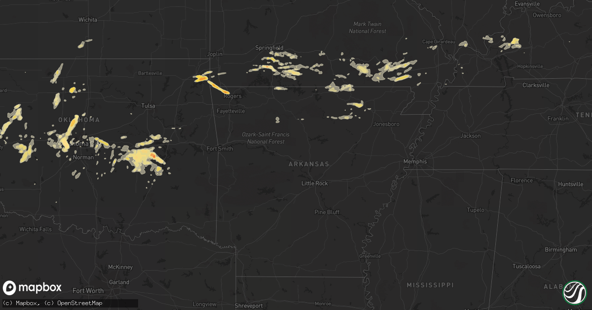
Hail Map in Missouri on September 26, 2012
Get this storm
September 26 map
$229
one time, instant access
Download today. No call, no setup
Keep the $229
Bought the map and want the full workflow? Apply the entire $229 to a subscription within 7 days. None of it is wasted.
Every map, not just this one
This buys you this map. Subscription and you get every map we run, in the markets you choose from a few cities to whole states to nationwide. Plus real-time alerts the moment a storm fires.
Contact data
Name, contact info, occupancy, even credit band for addresses in the footprint. You go from where it hit to who to call.
Become the source they trust
Unlimited branding weather history reports on demand. You already have the documented answer ready for the property owner, and you are the one who showed up with it.
Property data and RoofTrace estimates
Pull up any address you have got, its value and the exact code rules for that jurisdiction, straight from One Click Code. Then RoofTrace estimates the squares, pitch, and roof value, priced the way you price.
Storm reports in Missouri
Missouri
| Date | Description |
|---|---|
| 09/26/20124:27 PM CDT | Reported at intersection of highway aa and county road 629 in broseley. |
| 09/25/201211:16 PM CDT | A local report indicates 1.00 inch wind near 2 SSE OZARK |
| 09/25/20129:15 PM CDT | A local report indicates 1.00 inch wind near 2 S SPOKANE |
| 09/25/20129:10 PM CDT | Communications received report of near golf ball hail just southwest of town. |
| 09/25/20129:10 PM CDT | 1 inch hail reported at abesville. |
| 09/25/20128:25 PM CDT | Nickel to quarter hail in noel |
| 09/25/20128:23 PM CDT | Golf ball sized hail reported. Other reports of nickel and quarter sized hail. |
All States Impacted by Hail Map on September 26, 2012
Cities Impacted by Hail Map on September 26, 2012
- Spokane, MO
- Galena, MO
- Enid, OK
- Seiling, OK
- Quitaque, TX
- Silverton, TX
- Pritchett, CO
- Grand Chain, IL
- Karnak, IL
- Olmsted, IL
- Lubbock, TX
- Wilson, TX
- Plains, TX
- Big Bend, WV
- Big Springs, WV
- Matador, TX
- Vienna, IL
- Colony, OK
- Corn, OK
- Poplar Bluff, MO
- Broseley, MO
- Qulin, MO
- Lockney, TX
- Blanchard, OK
- Alex, OK
- Bradley, OK
- Lindsay, OK
- Seaman, OH
- Winchester, OH
- Fairmont, OK
- Garber, OK
- Hugoton, KS
- Keyes, OK
- Campo, CO
- Elkhart, KS
- Guymon, OK
- Goodwell, OK
- Hooker, OK
- Walsh, CO
- Rolla, KS
- Leon, WV
- Mount Alto, WV
- Le Roy, WV
- Cottageville, WV
- Ripley, WV
- Letart, WV
- Evans, WV
- Point Pleasant, WV
- Alton, MO
- Fremont, MO
- Doniphan, MO
- Seymour, MO
- Fordland, MO
- Afton, OK
- Fairland, OK
- Calvin, OK
- Reeds Spring, MO
- Tecumseh, OK
- Shawnee, OK
- Marquand, MO
- Thayer, MO
- Mammoth Spring, AR
- Camp, AR
- Warsaw, KY
- Verona, KY
- Williamsville, MO
- Hickman, KY
- Poughkeepsie, AR
- Hardy, AR
- Smithville, AR
- Ravenden, AR
- Ash Flat, AR
- Williford, AR
- Imboden, AR
- Black Rock, AR
- Levelland, TX
- Ropesville, TX
- Quanah, TX
- Post, TX
- Loop, TX
- Littlefield, TX
- Wolfforth, TX
- Seagraves, TX
- Tahoka, TX
- Tokio, TX
- Shallowater, TX
- Lorenzo, TX
- Smyer, TX
- Meadow, TX
- Brownfield, TX
- Slaton, TX
- Clarendon, TX
- Yukon, OK
- Wellston, OK
- Luther, OK
- Mcloud, OK
- Jones, OK
- Newalla, OK
- Meeker, OK
- Harrah, OK
- Choctaw, OK
- Drummond, OK
- Ames, OK
- Waukomis, OK
- Bardwell, KY
- Princeton, KY
- Butler, OK
- Seneca, MO
- Wyandotte, OK
- Grove, OK
- Idalou, TX
- Flomot, TX
- Turkey, TX
- Kit Carson, CO
- Spencer, WV
- Belle Plaine, KS
- Wellington, KS
- Trinidad, CO
- Model, CO
- Cheyenne, OK
- Sweetwater, OK
- Mayfield, KS
- New Deal, TX
- Abernathy, TX
- Springfield, CO
- Kim, CO
- Goodman, MO
- Stella, MO
- Anderson, MO
- Neosho, MO
- Perryton, TX
- Hardesty, OK
- Balko, OK
- Neelyville, MO
- Fisk, MO
- Okemah, OK
- Weleetka, OK
- Wewoka, OK
- Mcalester, OK
- Canadian, OK
- Dustin, OK
- Henryetta, OK
- Holdenville, OK
- Wetumka, OK
- Eufaula, OK
- Lamar, OK
- Crowder, OK
- Atwood, OK
- Hanna, OK
- Indianola, OK
- Tarzan, TX
- Noel, MO
- Lanesville, IN
- Corydon, IN
- Grayson, KY
- Booker, TX
- Marathon, TX
- Gardendale, TX
- Dawson Springs, KY
- Providence, KY
- Nebo, KY
- Crescent, OK
- Cashion, OK
- Guthrie, OK
- Taloga, OK
- El Reno, OK
- Goldsmith, TX
- Gail, TX
- Odonnell, TX
- Andrews, TX
- Seminole, TX
- Dudley, MO
- Chadwick, MO
- Walnut Shade, MO
- Chestnutridge, MO
- Crane, MO
- West Union, OH
- Hiwasse, AR
- Bentonville, AR
- Centerton, AR
- Grandin, MO
- Carnegie, OK
- Clinton, OK
- Gotebo, OK
- Hydro, OK
- Foss, OK
- Weatherford, OK
- Cordell, OK
- New Albany, IN
- Branson, CO
- Bison, OK
- Ozark, MO
- Lahoma, OK
- Hennessey, OK
- Georgetown, IN
- Flagler, CO
- Rogersville, MO
- Springfield, MO
- Nixa, MO
- Bethune, CO
- Stratton, CO
- Vona, CO
- Hale Center, TX
- Billings, MO
- Garrison, MO
- Clever, MO
- Sparta, MO
- Mustang, OK
- Byars, OK
- Salem, KY
- Hampton, KY
- Southside, WV
- Cave City, AR
- Batesville, AR
- Sidney, AR
- Mount Pleasant, AR
- Sulphur Rock, AR
- Hammon, OK
- Elk City, OK
- Coxs Mills, WV
- Glenville, WV
- Pauls Valley, OK
- Argillite, KY
- Kenova, WV
- Rush, KY
- Emerson, KY
- Vanceburg, KY
- Huntington, WV
- Olive Hill, KY
- Catlettsburg, KY
- Ashland, KY
- Guion, AR
- Gravette, AR
- Bella Vista, AR
- South West City, MO
- Sulphur Springs, AR
- Mulhall, OK
- Oklahoma City, OK
- Newcastle, OK
- Chester, OK
- Dickens, TX
- Brighton, CO
- Gould, OK
- Geary, OK
- Chloe, WV
- Lead Hill, AR
- Omaha, AR
- Marion, KY
- Sturkie, AR
- Viola, AR
- Salem, AR
- Okmulgee, OK
- Reydon, OK
- Coyanosa, TX
- Gallipolis, OH
- Nash, OK
- Waterloo, OH
- Morris, OK
- Bristow, IN
- Saint Meinrad, IN
- Minford, OH
- Thornfield, MO
- Plainview, TX
- Hollis, OK
- Stanton, TX
- Midland, TX
- Odessa, TX
- Aurora, MO
- Nebo, WV
- Duck, WV
- Claude, TX
- Crane, TX
- Monahans, TX
- Bruner, MO
- Jackson, OH
- Oak Hill, OH
- Lucasville, OH
- Lenorah, TX
- Dexter, MO
- Bernie, MO
- Grantsville, WV
- Paden, OK
- Spearman, TX
- Lamesa, TX
- Wappapello, MO
- Puxico, MO
- Ellsinore, MO
- Orma, WV
- Newton, WV
- Frametown, WV
- Looneyville, WV
- Purcell, OK
- Kiowa, OK
- Ferdinand, IN
- Pedro, OH
- Patriot, OH
- Scott City, MO
- Chaffee, MO
- Leedey, OK
- Custer City, OK
- Bradleyville, MO
- Theodosia, MO
- Noble, MO
- Ava, MO
- Squires, MO
- Essex, MO
- Parma, MO
- Grandfalls, TX
- Oldfield, MO
- Buckhannon, WV
- Gallipolis Ferry, WV
- Apple Grove, WV
- Cabool, MO
- Willow Springs, MO
- Owenton, KY
- Crosbyton, TX
- Lookeba, OK
- Leavenworth, IN
- Elizabeth, IN
- Laconia, IN
- New Middletown, IN
- Thomas, OK
- West Columbia, WV
- Cheshire, OH
- Trinchera, CO
- Boynton, OK
- Council Hill, OK
- Bloomfield, MO
- Peebles, OH
- Piketon, OH
- Rarden, OH
- Sand Fork, WV
- Cedarville, WV
- Norman, OK
- Tell City, IN
- Anton, TX
- Seibert, CO
- Cheyenne Wells, CO
- Highlandville, MO
- Hereford, TX
- Weston, CO
- Weston, WV
- Prospect, KY
- Louisville, KY
- Jeffersonville, IN
- Otway, OH
- Crown City, OH
- Given, WV
- Kenna, WV
- Henderson, WV
- Gay, WV
- Gandeeville, WV
- Liberty, WV
- Amarillo, TX
- Wildorado, TX
- Maud, OK
- Dora, MO
- Bristow, OK
- Mannford, OK
- Calumet, OK
- Okarche, OK
- Marshall, AR
- Leslie, AR
- Clayton, NM
- Evening Shade, AR
- Seminole, OK
- Harviell, MO
- Naylor, MO
- Fairdealing, MO
- Altus, OK
- Dale, IN
- Checotah, OK
- Hamersville, OH
- Bethel, OH
- Childress, TX
- Georgetown, OH
- Sayre, OK
- San Jon, NM
- Bard, NM
- Goltry, OK
- Lawton, OK
- Medicine Park, OK
- Brixey, MO
- Drury, MO
- Vanzant, MO
- Pottersville, MO
- Clarksville, IN
- Forsyth, MO
- Taneyville, MO
- West Plains, MO
- Edmond, OK
- Piedmont, OK
- Westcliffe, CO
- Canyon, TX
- Mclean, TX
- Sutton, WV
- Eminence, MO
- Summersville, MO
- Moody, MO
- Kingfisher, OK
- Fredonia, KY
- Eddyville, KY
- Oakwood, OK
- Adrian, TX
- Van Buren, MO
- Winona, MO
- Birch Tree, MO
- Dongola, IL
- Earlsboro, OK
- Ralls, TX
- Mountain View, AR
- Walnut Ridge, AR
- Hoxie, AR
- Portia, AR
- Racine, OH
- Minco, OK
- Tuttle, OK
- Union City, OK
- Waverly, OH
- Beaver, OH
- Arlington, KY
- Buncombe, IL
- Cypress, IL
- Thurman, OH
- South Webster, OH
- Ransom Canyon, TX
- Konawa, OK
- Felicity, OH
- Couch, MO
- Koshkonong, MO
- Normantown, WV
- Brohard, WV
- Payneville, KY
- Leopold, IN
- English, IN
- Afton, TX
- Richfield, KS
- Chillicothe, TX
- Tamms, IL
- Thebes, IL
- Stuart, OK
- Prague, OK
- Mountain Grove, MO
- Vendor, AR
- Mount Judea, AR
- Vinton, OH
- Wheeler, TX
- Muskogee, OK
- Comanche, OK
- Alva, OK
- Hinton, OK
- Roaring Springs, TX
- Happy, TX
- Wayside, TX
- Coyle, OK
- Greenup, KY
- Linn, WV
- Olustee, OK
- Johnstown, CO
- Berthoud, CO
- Ponce De Leon, MO
- Branson, MO
- Cape Fair, MO
- Rockaway Beach, MO
- Vega, TX
- Colorado Springs, CO
- Powhatan, AR
- Duke, OK
- Hartshorne, OK
- Quinton, OK
- Branchville, IN
- Ullin, IL
- Anna, IL
- Jonesboro, IL
- Wasola, MO
- Lamar, IN
- Santa Claus, IN
- Vernon, TX
- Krebs, OK
- Bowlegs, OK
- Shamrock, TX
- Saint Croix, IN
- Battletown, KY
- Douglas, OK
- Covington, OK
- Tulia, TX
- Fort Cobb, OK
- Oktaha, OK
- Billings, OK
- Perry, OK
- Palestine, WV
- Gamaliel, AR
- Strawberry, AR
- Spencer, OK
- Hunter, OK
- Kuttawa, KY
- Pond Creek, OK
- Jet, OK
- Wakita, OK
- Pocasset, OK
- Saffell, AR
- Simpson, IL
- Stonefort, IL
- Tallmansville, WV
- Cassville, MO
- Kissee Mills, MO
- Albion, IL
- Browns, IL
- Denver, CO
- Boley, OK
- Castle, OK
- Crestwood, KY
- Evanston, IN
- Munday, WV
- Mountain View, MO
- Macomb, OK
- Wanette, OK
- Smithland, KY
- Burna, KY
- Golconda, IL
- Amber, OK
- Platteville, CO
- Bethany, OK
- Liberal, KS
- Wardville, OK
- Morgantown, KY
- Gassaway, WV
- Floydada, TX
- Malden, MO
- Clinton, KY


