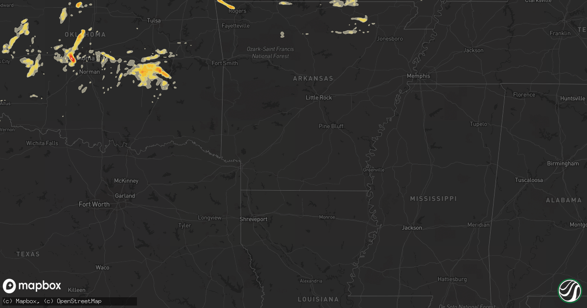
Hail Map on September 26, 2012
Get this storm
September 26 map
$229
one time, instant access
Download today. No call, no setup
Keep the $229
Bought the map and want the full workflow? Apply the entire $229 to a subscription within 7 days. None of it is wasted.
Every map, not just this one
This buys you this map. Subscription and you get every map we run, in the markets you choose from a few cities to whole states to nationwide. Plus real-time alerts the moment a storm fires.
Contact data
Name, contact info, occupancy, even credit band for addresses in the footprint. You go from where it hit to who to call.
Become the source they trust
Unlimited branding weather history reports on demand. You already have the documented answer ready for the property owner, and you are the one who showed up with it.
Property data and RoofTrace estimates
Pull up any address you have got, its value and the exact code rules for that jurisdiction, straight from One Click Code. Then RoofTrace estimates the squares, pitch, and roof value, priced the way you price.
States Impacted by Hail Map on September 26, 2012
Storm reports
Ohio
| Date | Description |
|---|---|
| 09/25/20128:50 PM CDT | Along riegel ridge rd |
| 09/25/20128:28 PM CDT | A local report indicates 1.00 inch wind near 3 WSW STOCKDALE |
Kansas
| Date | Description |
|---|---|
| 09/25/20128:30 PM CDT | A local report indicates 60 MPH wind near 6 SSE ROLLA |
| 09/25/20127:51 PM CDT | A local report indicates 1.00 inch wind near 2 NNW ELKHART |
| 09/25/20127:49 PM CDT | A local report indicates 65 MPH wind near 5 NNE ELKHART |
West Virginia
| Date | Description |
|---|---|
| 09/26/20126:00 PM CDT | Trees down along sycamore run rd north of glenville. |
| 09/26/20125:42 PM CDT | A local report indicates 1.00 inch wind near 2 S WESTON |
| 09/26/20125:20 PM CDT | A local report indicates 1.00 inch wind near 5 E LEON |
| 09/26/20125:20 PM CDT | A local report indicates 1.00 inch wind near 5 SE LEON |
| 09/25/20127:35 PM CDT | A local report indicates 1.00 inch wind near RIPLEY |
Colorado
| Date | Description |
|---|---|
| 09/26/20124:43 PM CDT | Hail was fairly soft. |
| 09/26/20124:05 PM CDT | 3/4 to 1 inch hail covering the ground to a depth of 3 inches. |
| 09/25/20128:19 PM CDT | Hail covering the ground to several inches |
| 09/25/20127:20 PM CDT | Hail up to 2 inches deep on highway 24 |
| 09/25/20127:10 PM CDT | Ended 620 pm. Mostly nickle size hail. Hail fall 2 inches deep on the ground. |
Oklahoma
| Date | Description |
|---|---|
| 09/26/20126:17 PM CDT | Half dollar size hail lasted about 3 min and the seneca-cayuga dept of public safety. |
| 09/26/20126:07 PM CDT | Pictures received of golfball and hen egg hail. |
| 09/26/20125:33 PM CDT | Dime to quarter hail reported. |
| 09/26/20125:18 PM CDT | Scattered limbs down around town. |
| 09/26/20125:12 PM CDT | A local report indicates 1.00 inch wind near NNW MCALESTER |
| 09/26/20124:30 PM CDT | The hail fell near wetumka lake. |
| 09/26/20124:06 PM CDT | Storm chaser reported quarter size hail with occasional golf ball hail. Relayed by media. |
| 09/26/20124:06 PM CDT | Storm chaser estimated 80 mph winds. Relyaed by media. |
| 09/26/20124:05 PM CDT | A local report indicates 1.00 inch wind near CROWDER |
| 09/26/20123:29 PM CDT | Law enforcement reporting half dollar hail on hwy 9 2 east of sh 52. Relayed through em. |
| 09/26/20123:27 PM CDT | A local report indicates 2.00 inch wind near 2 E HANNA |
| 09/26/20123:14 PM CDT | Quarter size hail observed at hwy 9 and the indian nation turnpike. |
| 09/26/20122:50 PM CDT | A local report indicates 1.00 inch wind near DUSTIN |
| 09/26/20121:54 PM CDT | A local report indicates 1.50 inch wind near 3 E WELEETKA |
| 09/26/201212:10 AM CDT | A local report indicates 1.00 inch wind near 7 NNE NASH |
| 09/25/201211:49 PM CDT | A local report indicates 1.75 inch wind near BRECKENRIDGE |
| 09/25/201211:15 PM CDT | A local report indicates 59 MPH wind near 2 SSW MINCO |
| 09/25/201211:10 PM CDT | A local report indicates 67 MPH wind near 2 SSW MINCO |
| 09/25/201211:00 PM CDT | A local report indicates 67 MPH wind near 2 SSW MINCO |
| 09/25/201210:55 PM CDT | A local report indicates 1.00 inch wind near 8 SE SEILING |
| 09/25/201210:55 PM CDT | A local report indicates 63 MPH wind near 2 SSW MINCO |
| 09/25/201210:45 PM CDT | A local report indicates 68 MPH wind near 3 W MEDICINE PARK |
| 09/25/201210:30 PM CDT | A local report indicates 61 MPH wind near 3 W MEDICINE PARK |
| 09/25/20129:57 PM CDT | The hail was reported near crescent park. Some damage was reported to automobiles. |
| 09/25/20129:45 PM CDT | A local report indicates 1.75 inch wind near 6 NW MUSTANG |
| 09/25/20129:35 PM CDT | Reported by twin lakes fire department. Time estimated from radar. |
| 09/25/20129:32 PM CDT | A local report indicates 1.00 inch wind near COWDEN |
| 09/25/20129:31 PM CDT | A local report indicates 58 MPH wind near 1 SE FREDERICK |
| 09/25/20129:25 PM CDT | A local report indicates 3.00 inch wind near 5 WNW MUSTANG |
| 09/25/20129:25 PM CDT | A local report indicates 66 MPH wind near 3 S ALTUS |
| 09/25/20129:23 PM CDT | A local report indicates 1.75 inch wind near 3 WNW MUSTANG |
| 09/25/20129:18 PM CDT | A local report indicates 1.75 inch wind near HOOKER |
| 09/25/20129:14 PM CDT | A local report indicates 1.25 inch wind near HOOKER |
| 09/25/20129:14 PM CDT | A local report indicates 1.00 inch wind near 1 N GUYMON |
| 09/25/20129:13 PM CDT | A local report indicates 1.25 inch wind near 3 S SEILING |
| 09/25/20129:12 PM CDT | A local report indicates 1.00 inch wind near GUYMON |
| 09/25/20129:05 PM CDT | A local report indicates 1.00 inch wind near HOOKER |
| 09/25/20128:55 PM CDT | A local report indicates 1.25 inch wind near 4 W HOOKER |
| 09/25/20128:39 PM CDT | Hail covering the ground. Also estimated wind gusts between 50 and 60 mph. |
| 09/25/20128:25 PM CDT | Also estimated wind gusts to 50 mph. |
| 09/25/20128:08 PM CDT | Reported on the west side of town |
| 09/25/20128:00 PM CDT | Time estimated from radar. |
| 09/25/20127:50 PM CDT | A local report indicates 1.75 inch wind near 2 N DEMPSEY |
| 09/25/20127:45 PM CDT | A local report indicates 1.00 inch wind near 13 N EVA |
Missouri
| Date | Description |
|---|---|
| 09/26/20124:27 PM CDT | Reported at intersection of highway aa and county road 629 in broseley. |
| 09/25/201211:16 PM CDT | A local report indicates 1.00 inch wind near 2 SSE OZARK |
| 09/25/20129:15 PM CDT | A local report indicates 1.00 inch wind near 2 S SPOKANE |
| 09/25/20129:10 PM CDT | 1 inch hail reported at abesville. |
| 09/25/20129:10 PM CDT | Communications received report of near golf ball hail just southwest of town. |
| 09/25/20128:25 PM CDT | Nickel to quarter hail in noel |
| 09/25/20128:23 PM CDT | Golf ball sized hail reported. Other reports of nickel and quarter sized hail. |
Texas
| Date | Description |
|---|---|
| 09/26/20126:35 PM CDT | *** 1 inj *** us highway 84 southbound closed due to tractor trailer truck blown over. Driver injured. |
| 09/26/20126:12 PM CDT | Tv weather station report |
| 09/26/20126:02 PM CDT | Trained spotter coop report |
| 09/26/20126:00 PM CDT | Golf ball to hen egg-sized hail reported near gardendale post office |
| 09/26/20125:50 PM CDT | A local report indicates 60 MPH wind near 13 NW TARZAN |
| 09/26/20125:50 PM CDT | A local report indicates 1.00 inch wind near 13 NW TARZAN |
| 09/26/20125:38 PM CDT | West texas mesonet report |
| 09/26/20125:32 PM CDT | West texas mesonet report |
| 09/26/20125:10 PM CDT | West texas mesonet report |
| 09/26/20124:43 PM CDT | West texas mesonet report |
| 09/26/20124:10 PM CDT | Quarter to nickel-sized hail reported in coyanosa |
| 09/25/201210:30 PM CDT | A local report indicates 60 MPH wind near FARNSWORTH |
| 09/25/201210:30 PM CDT | A local report indicates 1.00 inch wind near FARNSWORTH |
| 09/25/201210:20 PM CDT | Time estimated |
| 09/25/201210:08 PM CDT | Reported quarter size to half dollar size hail |
| 09/25/201210:00 PM CDT | Power lines blown down and irrigation sprinkler system knocked over. Time is estimated based on radar. |
| 09/25/20127:45 PM CDT | West texas mesonet report |
| 09/25/20127:35 PM CDT | Downed tree damaged a fence. |
| 09/25/20127:30 PM CDT | 59 mph gust at 725 and 60 mph at 735. Measured by west tx mesonet. |
Arkansas
| Date | Description |
|---|---|
| 09/25/20129:15 PM CDT | A local report indicates 1.00 inch wind near BENTONVILLE |
| 09/25/20128:59 PM CDT | Spotter 4 to 5 e of hiwasse on hwy 72 estimated wind gust to 65 mph. |
| 09/25/20128:58 PM CDT | Duration of hail was approximately 5 minutes. |
Kentucky
| Date | Description |
|---|---|
| 09/26/20126:41 PM CDT | A local report indicates 1.00 inch wind near CANNONSBURG |
| 09/26/20126:32 PM CDT | A local report indicates 1.00 inch wind near 3 N RUSH |
| 09/26/20126:23 PM CDT | Also winds gusting up to 40 mph |
| 09/26/20126:15 PM CDT | A local report indicates 1.00 inch wind near 4 NNW GRAYSON |
Cities Impacted by Hail Map on September 26, 2012
- Spokane, MO
- Galena, MO
- Enid, OK
- Seiling, OK
- Quitaque, TX
- Silverton, TX
- Pritchett, CO
- Grand Chain, IL
- Karnak, IL
- Olmsted, IL
- Lubbock, TX
- Wilson, TX
- Plains, TX
- Big Bend, WV
- Big Springs, WV
- Matador, TX
- Vienna, IL
- Colony, OK
- Corn, OK
- Poplar Bluff, MO
- Broseley, MO
- Qulin, MO
- Lockney, TX
- Blanchard, OK
- Alex, OK
- Bradley, OK
- Lindsay, OK
- Seaman, OH
- Winchester, OH
- Fairmont, OK
- Garber, OK
- Hugoton, KS
- Keyes, OK
- Campo, CO
- Elkhart, KS
- Guymon, OK
- Goodwell, OK
- Hooker, OK
- Walsh, CO
- Rolla, KS
- Leon, WV
- Mount Alto, WV
- Le Roy, WV
- Cottageville, WV
- Ripley, WV
- Letart, WV
- Evans, WV
- Point Pleasant, WV
- Alton, MO
- Fremont, MO
- Doniphan, MO
- Seymour, MO
- Fordland, MO
- Afton, OK
- Fairland, OK
- Calvin, OK
- Reeds Spring, MO
- Tecumseh, OK
- Shawnee, OK
- Marquand, MO
- Thayer, MO
- Mammoth Spring, AR
- Camp, AR
- Warsaw, KY
- Verona, KY
- Williamsville, MO
- Hickman, KY
- Poughkeepsie, AR
- Hardy, AR
- Smithville, AR
- Ravenden, AR
- Ash Flat, AR
- Williford, AR
- Imboden, AR
- Black Rock, AR
- Levelland, TX
- Ropesville, TX
- Quanah, TX
- Post, TX
- Loop, TX
- Littlefield, TX
- Wolfforth, TX
- Seagraves, TX
- Tahoka, TX
- Tokio, TX
- Shallowater, TX
- Lorenzo, TX
- Smyer, TX
- Meadow, TX
- Brownfield, TX
- Slaton, TX
- Clarendon, TX
- Yukon, OK
- Wellston, OK
- Luther, OK
- Mcloud, OK
- Jones, OK
- Newalla, OK
- Meeker, OK
- Harrah, OK
- Choctaw, OK
- Drummond, OK
- Ames, OK
- Waukomis, OK
- Bardwell, KY
- Princeton, KY
- Butler, OK
- Seneca, MO
- Wyandotte, OK
- Grove, OK
- Idalou, TX
- Flomot, TX
- Turkey, TX
- Kit Carson, CO
- Spencer, WV
- Belle Plaine, KS
- Wellington, KS
- Trinidad, CO
- Model, CO
- Cheyenne, OK
- Sweetwater, OK
- Mayfield, KS
- New Deal, TX
- Abernathy, TX
- Springfield, CO
- Kim, CO
- Goodman, MO
- Stella, MO
- Anderson, MO
- Neosho, MO
- Perryton, TX
- Hardesty, OK
- Balko, OK
- Neelyville, MO
- Fisk, MO
- Okemah, OK
- Weleetka, OK
- Wewoka, OK
- Mcalester, OK
- Canadian, OK
- Dustin, OK
- Henryetta, OK
- Holdenville, OK
- Wetumka, OK
- Eufaula, OK
- Lamar, OK
- Crowder, OK
- Atwood, OK
- Hanna, OK
- Indianola, OK
- Tarzan, TX
- Noel, MO
- Lanesville, IN
- Corydon, IN
- Grayson, KY
- Booker, TX
- Marathon, TX
- Gardendale, TX
- Dawson Springs, KY
- Providence, KY
- Nebo, KY
- Crescent, OK
- Cashion, OK
- Guthrie, OK
- Taloga, OK
- El Reno, OK
- Goldsmith, TX
- Gail, TX
- Odonnell, TX
- Andrews, TX
- Seminole, TX
- Dudley, MO
- Chadwick, MO
- Walnut Shade, MO
- Chestnutridge, MO
- Crane, MO
- West Union, OH
- Hiwasse, AR
- Bentonville, AR
- Centerton, AR
- Grandin, MO
- Carnegie, OK
- Clinton, OK
- Gotebo, OK
- Hydro, OK
- Foss, OK
- Weatherford, OK
- Cordell, OK
- New Albany, IN
- Branson, CO
- Bison, OK
- Ozark, MO
- Lahoma, OK
- Hennessey, OK
- Georgetown, IN
- Flagler, CO
- Rogersville, MO
- Springfield, MO
- Nixa, MO
- Bethune, CO
- Stratton, CO
- Vona, CO
- Hale Center, TX
- Billings, MO
- Garrison, MO
- Clever, MO
- Sparta, MO
- Mustang, OK
- Byars, OK
- Salem, KY
- Hampton, KY
- Southside, WV
- Cave City, AR
- Batesville, AR
- Sidney, AR
- Mount Pleasant, AR
- Sulphur Rock, AR
- Hammon, OK
- Elk City, OK
- Coxs Mills, WV
- Glenville, WV
- Pauls Valley, OK
- Argillite, KY
- Kenova, WV
- Rush, KY
- Emerson, KY
- Vanceburg, KY
- Huntington, WV
- Olive Hill, KY
- Catlettsburg, KY
- Ashland, KY
- Guion, AR
- Gravette, AR
- Bella Vista, AR
- South West City, MO
- Sulphur Springs, AR
- Mulhall, OK
- Oklahoma City, OK
- Newcastle, OK
- Chester, OK
- Dickens, TX
- Brighton, CO
- Gould, OK
- Geary, OK
- Chloe, WV
- Lead Hill, AR
- Omaha, AR
- Marion, KY
- Sturkie, AR
- Viola, AR
- Salem, AR
- Okmulgee, OK
- Reydon, OK
- Coyanosa, TX
- Gallipolis, OH
- Nash, OK
- Waterloo, OH
- Morris, OK
- Bristow, IN
- Saint Meinrad, IN
- Minford, OH
- Thornfield, MO
- Plainview, TX
- Hollis, OK
- Stanton, TX
- Midland, TX
- Odessa, TX
- Aurora, MO
- Nebo, WV
- Duck, WV
- Claude, TX
- Crane, TX
- Monahans, TX
- Bruner, MO
- Jackson, OH
- Oak Hill, OH
- Lucasville, OH
- Lenorah, TX
- Dexter, MO
- Bernie, MO
- Grantsville, WV
- Paden, OK
- Spearman, TX
- Lamesa, TX
- Wappapello, MO
- Puxico, MO
- Ellsinore, MO
- Orma, WV
- Newton, WV
- Frametown, WV
- Looneyville, WV
- Purcell, OK
- Kiowa, OK
- Ferdinand, IN
- Pedro, OH
- Patriot, OH
- Scott City, MO
- Chaffee, MO
- Leedey, OK
- Custer City, OK
- Bradleyville, MO
- Theodosia, MO
- Noble, MO
- Ava, MO
- Squires, MO
- Essex, MO
- Parma, MO
- Grandfalls, TX
- Oldfield, MO
- Buckhannon, WV
- Gallipolis Ferry, WV
- Apple Grove, WV
- Cabool, MO
- Willow Springs, MO
- Owenton, KY
- Crosbyton, TX
- Lookeba, OK
- Leavenworth, IN
- Elizabeth, IN
- Laconia, IN
- New Middletown, IN
- Thomas, OK
- West Columbia, WV
- Cheshire, OH
- Trinchera, CO
- Boynton, OK
- Council Hill, OK
- Bloomfield, MO
- Peebles, OH
- Piketon, OH
- Rarden, OH
- Sand Fork, WV
- Cedarville, WV
- Norman, OK
- Tell City, IN
- Anton, TX
- Seibert, CO
- Cheyenne Wells, CO
- Highlandville, MO
- Hereford, TX
- Weston, CO
- Weston, WV
- Prospect, KY
- Louisville, KY
- Jeffersonville, IN
- Otway, OH
- Crown City, OH
- Given, WV
- Kenna, WV
- Henderson, WV
- Gay, WV
- Gandeeville, WV
- Liberty, WV
- Amarillo, TX
- Wildorado, TX
- Maud, OK
- Dora, MO
- Bristow, OK
- Mannford, OK
- Calumet, OK
- Okarche, OK
- Marshall, AR
- Leslie, AR
- Clayton, NM
- Evening Shade, AR
- Seminole, OK
- Harviell, MO
- Naylor, MO
- Fairdealing, MO
- Altus, OK
- Dale, IN
- Checotah, OK
- Hamersville, OH
- Bethel, OH
- Childress, TX
- Georgetown, OH
- Sayre, OK
- San Jon, NM
- Bard, NM
- Goltry, OK
- Lawton, OK
- Medicine Park, OK
- Brixey, MO
- Drury, MO
- Vanzant, MO
- Pottersville, MO
- Clarksville, IN
- Forsyth, MO
- Taneyville, MO
- West Plains, MO
- Edmond, OK
- Piedmont, OK
- Westcliffe, CO
- Canyon, TX
- Mclean, TX
- Sutton, WV
- Eminence, MO
- Summersville, MO
- Moody, MO
- Kingfisher, OK
- Fredonia, KY
- Eddyville, KY
- Oakwood, OK
- Adrian, TX
- Van Buren, MO
- Winona, MO
- Birch Tree, MO
- Dongola, IL
- Earlsboro, OK
- Ralls, TX
- Mountain View, AR
- Walnut Ridge, AR
- Hoxie, AR
- Portia, AR
- Racine, OH
- Minco, OK
- Tuttle, OK
- Union City, OK
- Waverly, OH
- Beaver, OH
- Arlington, KY
- Buncombe, IL
- Cypress, IL
- Thurman, OH
- South Webster, OH
- Ransom Canyon, TX
- Konawa, OK
- Felicity, OH
- Couch, MO
- Koshkonong, MO
- Normantown, WV
- Brohard, WV
- Payneville, KY
- Leopold, IN
- English, IN
- Afton, TX
- Richfield, KS
- Chillicothe, TX
- Tamms, IL
- Thebes, IL
- Stuart, OK
- Prague, OK
- Mountain Grove, MO
- Vendor, AR
- Mount Judea, AR
- Vinton, OH
- Wheeler, TX
- Muskogee, OK
- Comanche, OK
- Alva, OK
- Hinton, OK
- Roaring Springs, TX
- Happy, TX
- Wayside, TX
- Coyle, OK
- Greenup, KY
- Linn, WV
- Olustee, OK
- Johnstown, CO
- Berthoud, CO
- Ponce De Leon, MO
- Branson, MO
- Cape Fair, MO
- Rockaway Beach, MO
- Vega, TX
- Colorado Springs, CO
- Powhatan, AR
- Duke, OK
- Hartshorne, OK
- Quinton, OK
- Branchville, IN
- Ullin, IL
- Anna, IL
- Jonesboro, IL
- Wasola, MO
- Lamar, IN
- Santa Claus, IN
- Vernon, TX
- Krebs, OK
- Bowlegs, OK
- Shamrock, TX
- Saint Croix, IN
- Battletown, KY
- Douglas, OK
- Covington, OK
- Tulia, TX
- Fort Cobb, OK
- Oktaha, OK
- Billings, OK
- Perry, OK
- Palestine, WV
- Gamaliel, AR
- Strawberry, AR
- Spencer, OK
- Hunter, OK
- Kuttawa, KY
- Pond Creek, OK
- Jet, OK
- Wakita, OK
- Pocasset, OK
- Saffell, AR
- Simpson, IL
- Stonefort, IL
- Tallmansville, WV
- Cassville, MO
- Kissee Mills, MO
- Albion, IL
- Browns, IL
- Denver, CO
- Boley, OK
- Castle, OK
- Crestwood, KY
- Evanston, IN
- Munday, WV
- Mountain View, MO
- Macomb, OK
- Wanette, OK
- Smithland, KY
- Burna, KY
- Golconda, IL
- Amber, OK
- Platteville, CO
- Bethany, OK
- Liberal, KS
- Wardville, OK
- Morgantown, KY
- Gassaway, WV
- Floydada, TX
- Malden, MO
- Clinton, KY