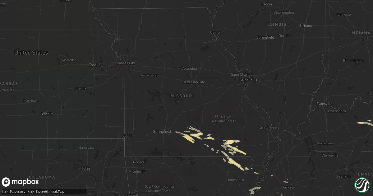
Hail Map in Missouri on September 24, 2022
Get this storm
September 24 map
$229
one time, instant access
Download today. No call, no setup
Keep the $229
Bought the map and want the full workflow? Apply the entire $229 to a subscription within 7 days. None of it is wasted.
Every map, not just this one
This buys you this map. Subscription and you get every map we run, in the markets you choose from a few cities to whole states to nationwide. Plus real-time alerts the moment a storm fires.
Contact data
Name, contact info, occupancy, even credit band for addresses in the footprint. You go from where it hit to who to call.
Become the source they trust
Unlimited branding weather history reports on demand. You already have the documented answer ready for the property owner, and you are the one who showed up with it.
Property data and RoofTrace estimates
Pull up any address you have got, its value and the exact code rules for that jurisdiction, straight from One Click Code. Then RoofTrace estimates the squares, pitch, and roof value, priced the way you price.
Storm reports in Missouri
Missouri
| Date | Description |
|---|---|
| 09/24/20226:03 PM CDT | Quarter sized hail reported just west of ellsinore... Mo in carter county. |
| 09/24/20225:17 PM CDT | Carter county emergency manager reports golf ball sized hail in hunter... Mo. |
| 09/24/20224:45 PM CDT | Three inch limbs down along a rural road. Some pieces of tin noted in the road. |
| 09/24/20222:33 AM CDT | At 733 PM CDT, a severe thunderstorm was located near Reyno, or 11 miles west of Corning, moving southeast at 30 mph. HAZARD...60 mph wind gusts and half dollar size hail. SOURCE...Radar indicated. IMPACT...Hail damage to vehicles is expected. Expect wind damage to roofs, siding, and trees. Locations impacted include... Corning, Lafe, Reyno, Knobel, O'Kean, Success, Peach Orchard, Delaplaine, Datto, Evening Star, Beech Grove, Heelstring, Stonewall, Tipperary, Case, Brookings, Knob, Twin Oaks, Palatka and Faulknerville. |
| 09/24/20222:15 AM CDT | At 715 PM CDT, a severe thunderstorm was located near Maynard, or 12 miles southwest of Doniphan, moving southeast at 30 mph. HAZARD...60 mph wind gusts and quarter size hail. SOURCE...Radar indicated. IMPACT...Hail damage to vehicles is expected. Expect wind damage to roofs, siding, and trees. Locations impacted include... Reyno... Maynard... Biggers... O'Kean... Elkins Park... Brakebill... Middlebrook... Warm Springs... Ingram... Stokes... Engelerg... Brockett... Pitman... |
| 09/24/20222:08 AM CDT | At 707 PM CDT, a severe thunderstorm was located 8 miles south of Mountain Grove, moving southeast at 30 mph. HAZARD...60 mph wind gusts and quarter size hail. SOURCE...Radar indicated. IMPACT...Hail damage to vehicles is expected. Expect wind damage to roofs, siding, and trees. Locations impacted include... Mountain Grove, Willow Springs, Norwood, Siloam Springs, Drury and Vanzant. |
| 09/24/20222:01 AM CDT | At 701 PM CDT, a severe thunderstorm was located near Gatewood, or 11 miles southwest of Doniphan, moving southeast at 35 mph. HAZARD...60 mph wind gusts and quarter size hail. SOURCE...Radar indicated. IMPACT...Hail damage to vehicles is expected. Expect wind damage to roofs, siding, and trees. This severe thunderstorm will remain over mainly rural areas of southwestern Ripley County. |
| 09/24/20221:28 AM CDT | At 628 PM CDT, a severe thunderstorm was located near Qulin, or near Chalk Bluff Natural Area, moving southeast at 30 mph. HAZARD...60 mph wind gusts and half dollar size hail. SOURCE...Radar indicated. IMPACT...Hail damage to vehicles is expected. Expect wind damage to roofs, siding, and trees. Locations impacted include... Gideon. |
| 09/24/20221:25 AM CDT | At 625 PM CDT, a severe thunderstorm was located near Fairdealing, or 9 miles northeast of Doniphan, moving southeast at 30 mph. HAZARD...60 mph wind gusts and quarter size hail. SOURCE...Radar indicated. IMPACT...Hail damage to vehicles is expected. Expect wind damage to roofs, siding, and trees. This severe thunderstorm will be near... Fairdealing around 630 PM CDT. Naylor around 640 PM CDT. Harviell around 645 PM CDT.Other locations in the path of this severe thunderstorm includeNeelyville. |
| 09/24/20221:22 AM CDT | At 622 PM CDT, a severe thunderstorm was located near Williamsville, or 14 miles west of Lake Wappapello State Park, moving east at 30 mph. HAZARD...60 mph wind gusts and half dollar size hail. SOURCE...Radar indicated. IMPACT...Hail damage to vehicles is expected. Expect wind damage to roofs, siding, and trees. This severe thunderstorm will be near... Hendrickson around 635 PM CDT.Other locations in the path of this severe thunderstorm include LakeWappapello State Park. |
| 09/24/202212:56 AM CDT | At 556 PM CDT, a severe thunderstorm was located over Harviell, or 8 miles southwest of Poplar Bluff, moving east at 30 mph. HAZARD...60 mph wind gusts and quarter size hail. SOURCE...Radar indicated. IMPACT...Hail damage to vehicles is expected. Expect wind damage to roofs, siding, and trees. Locations impacted include... Qulin. |
| 09/24/202212:50 AM CDT | At 550 PM CDT, a severe thunderstorm was located near Hunter, or 9 miles southeast of Van Buren, moving east at 40 mph. HAZARD...60 mph wind gusts and quarter size hail. SOURCE...Radar indicated. IMPACT...Hail damage to vehicles is expected. Expect wind damage to roofs, siding, and trees. This severe thunderstorm will be near... Ellsinore around 600 PM CDT. Brush Arbor around 605 PM CDT.Other locations in the path of this severe thunderstorm includeWilliamsville. |
| 09/24/202212:27 AM CDT | At 527 PM CDT, a severe thunderstorm was located over Budapest, or 11 miles northeast of Doniphan, moving east at 30 mph. HAZARD...60 mph wind gusts and quarter size hail. SOURCE...Radar indicated. IMPACT...Hail damage to vehicles is expected. Expect wind damage to roofs, siding, and trees. This severe thunderstorm will be near... Milltown around 535 PM CDT. Fairdealing around 540 PM CDT.Other locations in the path of this severe thunderstorm includePoplar Bluff and Harviell. |
| 09/24/202212:04 AM CDT | At 503 PM CDT, a severe thunderstorm was located near Birch Tree, or 8 miles east of Mountain View, moving east at 30 mph. HAZARD...60 mph wind gusts and quarter size hail. SOURCE...Radar indicated. IMPACT...Hail damage to vehicles is expected. Expect wind damage to roofs, siding, and trees. Locations impacted include... Ozark National Scenic Riverways, Winona, Birch Tree and Montier. |
| 09/24/202212:01 AM CDT | At 501 PM CDT, a severe thunderstorm was located over Hunter, or 12 miles southeast of Van Buren, moving east at 40 mph. HAZARD...60 mph wind gusts and quarter size hail. SOURCE...Radar indicated. IMPACT...Hail damage to vehicles is expected. Expect wind damage to roofs, siding, and trees. This severe thunderstorm will be near... Ellsinore around 510 PM CDT. Budapest around 515 PM CDT. Brush Arbor around 520 PM CDT.Other locations in the path of this severe thunderstorm includeMilltown, Poplar Bluff and Hendrickson. |
| 09/23/202211:55 PM CDT | At 454 PM CDT, a severe thunderstorm was located near Cabool, or 9 miles northwest of Willow Springs, moving east at 25 mph. HAZARD...60 mph wind gusts and quarter size hail. SOURCE...Radar indicated. IMPACT...Hail damage to vehicles is expected. Expect wind damage to roofs, siding, and trees. Locations impacted include... Mountain Grove, Willow Springs, Cabool, Norwood, Clear Springs and Elk Creek. |
| 09/23/202211:12 PM CDT | At 412 PM CDT, a severe thunderstorm was located near Seymour, or 14 miles southeast of Marshfield, moving east at 20 mph. HAZARD...60 mph wind gusts and quarter size hail. SOURCE...Radar indicated. IMPACT...Hail damage to vehicles is expected. Expect wind damage to roofs, siding, and trees. Locations impacted include... Mountain Grove, Seymour, Mansfield and Norwood. |
| 09/23/20229:05 PM CDT | A few trees down in steele as well as power outages in town. |
| 09/23/20228:50 PM CDT | Center pivot irrigation unit overturned near cotton plant off highway 164. Estimated 65 mph. |
| 09/23/20227:36 PM CDT | Trees reported down on highway 76 between county roads 149 and 156. |
| 09/23/20227:15 PM CDT | Report relayed via nwschat. Fire dept removing a lot of downed trees from cr-ee 155. |
All States Impacted by Hail Map on September 24, 2022
Cities Impacted by Hail Map on September 24, 2022
- Couch, MO
- Birch Tree, MO
- Mountain View, MO
- De Witt, AR
- Saint Charles, AR
- Sonora, KY
- Upton, KY
- Doniphan, MO
- Fremont, MO
- Ellsinore, MO
- Van Buren, MO
- Grandin, MO
- Willow Springs, MO
- Clarkson, KY
- Leitchfield, KY
- Alton, MO
- Knobel, AR
- Peach Orchard, AR
- Paragould, AR
- Lafe, AR
- Delaplaine, AR
- Biggers, AR
- Maynard, AR
- Corning, AR
- Pocahontas, AR
- Norwood, MO
- Dora, MO
- Mansfield, MO
- Ava, MO
- Mountain Grove, MO
- Drury, MO
- Macomb, MO
- Vanzant, MO
- Seymour, MO
- Elk Creek, MO
- Cabool, MO
- Bonnieville, KY
- Munfordville, KY
- Marmaduke, AR
- Ravenden Springs, AR
- Warm Springs, AR
- Harviell, MO
- Gadsden, TN
- Jackson, TN
- Humboldt, TN
- Qulin, MO
- Fairdealing, MO
- Poplar Bluff, MO
- Neelyville, MO
- Naylor, MO
- Senath, MO
- Rector, AR
- Burlison, TN
- Drummonds, TN
- Joiner, AR
- Frenchmans Bayou, AR
- Wilson, AR
- Henning, TN
- Osceola, AR
- Caneyville, KY
- Magnolia, KY
- Millwood, KY
- Gatewood, MO
- Summersville, MO
- Eminence, MO
- Toone, TN
- Peace Valley, MO
- West Plains, MO
- Hornersville, MO
- Williamsville, MO
- Tunica, MS
- Dundee, MS
- Oxly, MO
- Sarah, MS
- Graff, MO
- Whiteville, TN
- Dyersburg, TN
- Steele, MO
- Blytheville, AR
- Huggins, MO
- Houston, MO
- Solo, MO


