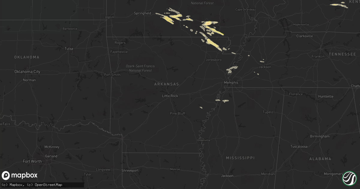
Hail Map in Arkansas on September 24, 2022
Get this storm
September 24 map
$229
one time, instant access
Download today. No call, no setup
Keep the $229
Bought the map and want the full workflow? Apply the entire $229 to a subscription within 7 days. None of it is wasted.
Every map, not just this one
This buys you this map. Subscription and you get every map we run, in the markets you choose from a few cities to whole states to nationwide. Plus real-time alerts the moment a storm fires.
Contact data
Name, contact info, occupancy, even credit band for addresses in the footprint. You go from where it hit to who to call.
Become the source they trust
Unlimited branding weather history reports on demand. You already have the documented answer ready for the property owner, and you are the one who showed up with it.
Property data and RoofTrace estimates
Pull up any address you have got, its value and the exact code rules for that jurisdiction, straight from One Click Code. Then RoofTrace estimates the squares, pitch, and roof value, priced the way you price.
Storm reports in Arkansas
Arkansas
| Date | Description |
|---|---|
| 09/24/20223:33 AM CDT | At 832 PM CDT, a severe thunderstorm was located over Joiner, or 8 miles southwest of Wilson, moving east at 50 mph. HAZARD...60 mph wind gusts. SOURCE...Radar indicated. IMPACT...Expect damage to roofs, siding, and trees. Locations impacted include... Bartlett, Millington, Wilson, Meeman Shelby Forest State Park, Lakeland, Arlington, Munford, Brighton, Joiner, Bassett, Dixonville, Tipton, Atoka, Gilt Edge, Evadale, Menesha, Locke, Randolph, Sloanville and Brunswick. |
| 09/24/20221:18 AM CDT | At 618 PM CDT, a severe thunderstorm was located near Qulin, or 9 miles northwest of Chalk Bluff Natural Area, moving southeast at 30 mph. HAZARD...60 mph wind gusts and quarter size hail. SOURCE...Radar indicated. IMPACT...Hail damage to vehicles is expected. Expect wind damage to roofs, siding, and trees. Locations impacted include... Malden, Campbell, Chalk Bluff Natural Area, Clarkton, Holcomb, St. Francis, Saint Francis, Glennonville, Valley Ridge, Providence, Morris State Park, Wilhelmina, Brian, Chalk Bluff Battlefield Park, Baird, McGuires and Townley. |
| 09/23/202211:21 PM CDT | At 420 PM CDT, a severe thunderstorm was located over Southwest Little Rock, moving east at 30 mph. HAZARD...60 mph wind gusts and penny size hail. SOURCE...Radar indicated. IMPACT...Expect damage to roofs, siding, and trees. Locations impacted include... Little Rock... North Little Rock... Benton... West Little Rock... Bryant... Downtown Little Rock... Lonoke... Southwest Little Rock... Shannon Hills... England... Wrightsville... Argenta... Keo... Otter Creek... Ironton... Estes... Meto... Toltec Mounds State Park... Protho Junction... Geyer Springs... |
| 09/23/20229:05 PM CDT | Tree down on a truck on county road 711. |
| 09/23/20229:05 PM CDT | Multiple trees and powerlines down. |
| 09/23/20228:15 PM CDT | Numerous trees down along cr 517 and 523 in the halliday area. |
| 09/23/20228:10 PM CDT | Numerous tree limbs down across lafe. |
All States Impacted by Hail Map on September 24, 2022
Cities Impacted by Hail Map on September 24, 2022
- Couch, MO
- Birch Tree, MO
- Mountain View, MO
- De Witt, AR
- Saint Charles, AR
- Sonora, KY
- Upton, KY
- Doniphan, MO
- Fremont, MO
- Ellsinore, MO
- Van Buren, MO
- Grandin, MO
- Willow Springs, MO
- Clarkson, KY
- Leitchfield, KY
- Alton, MO
- Knobel, AR
- Peach Orchard, AR
- Paragould, AR
- Lafe, AR
- Delaplaine, AR
- Biggers, AR
- Maynard, AR
- Corning, AR
- Pocahontas, AR
- Norwood, MO
- Dora, MO
- Mansfield, MO
- Ava, MO
- Mountain Grove, MO
- Drury, MO
- Macomb, MO
- Vanzant, MO
- Seymour, MO
- Elk Creek, MO
- Cabool, MO
- Bonnieville, KY
- Munfordville, KY
- Marmaduke, AR
- Ravenden Springs, AR
- Warm Springs, AR
- Harviell, MO
- Gadsden, TN
- Jackson, TN
- Humboldt, TN
- Qulin, MO
- Fairdealing, MO
- Poplar Bluff, MO
- Neelyville, MO
- Naylor, MO
- Senath, MO
- Rector, AR
- Burlison, TN
- Drummonds, TN
- Joiner, AR
- Frenchmans Bayou, AR
- Wilson, AR
- Henning, TN
- Osceola, AR
- Caneyville, KY
- Magnolia, KY
- Millwood, KY
- Gatewood, MO
- Summersville, MO
- Eminence, MO
- Toone, TN
- Peace Valley, MO
- West Plains, MO
- Hornersville, MO
- Williamsville, MO
- Tunica, MS
- Dundee, MS
- Oxly, MO
- Sarah, MS
- Graff, MO
- Whiteville, TN
- Dyersburg, TN
- Steele, MO
- Blytheville, AR
- Huggins, MO
- Houston, MO
- Solo, MO


