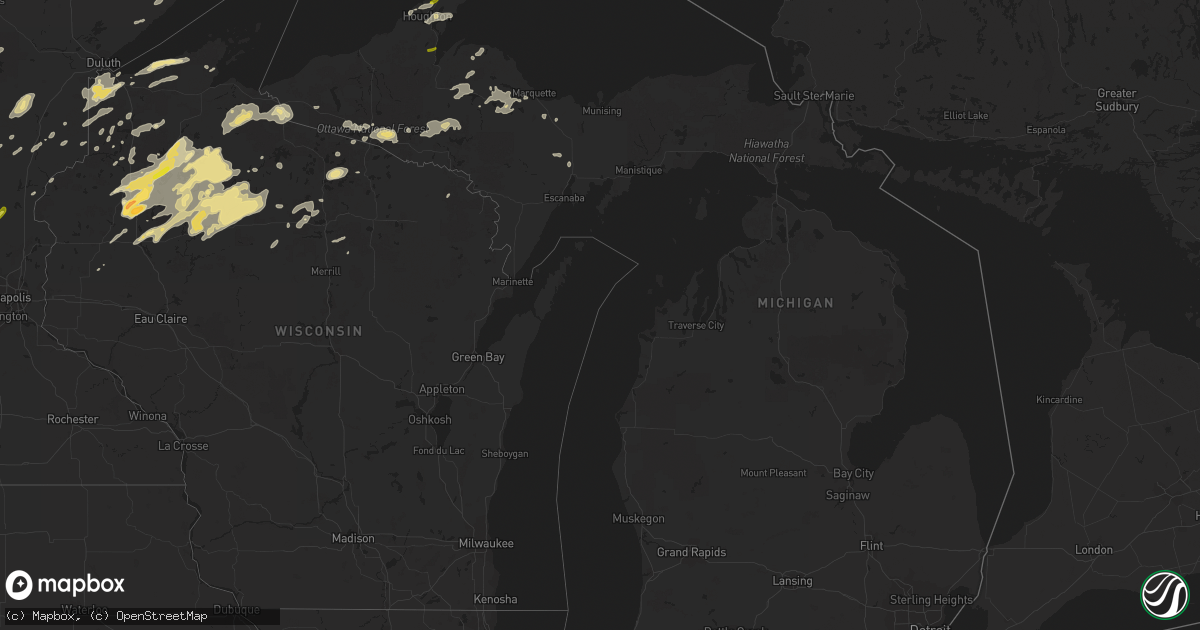
Hail Map in Michigan on September 22, 2017
Get this storm
September 22 map
$229
one time, instant access
Download today. No call, no setup
Keep the $229
Bought the map and want the full workflow? Apply the entire $229 to a subscription within 7 days. None of it is wasted.
Every map, not just this one
This buys you this map. Subscription and you get every map we run, in the markets you choose from a few cities to whole states to nationwide. Plus real-time alerts the moment a storm fires.
Contact data
Name, contact info, occupancy, even credit band for addresses in the footprint. You go from where it hit to who to call.
Become the source they trust
Unlimited branding weather history reports on demand. You already have the documented answer ready for the property owner, and you are the one who showed up with it.
Property data and RoofTrace estimates
Pull up any address you have got, its value and the exact code rules for that jurisdiction, straight from One Click Code. Then RoofTrace estimates the squares, pitch, and roof value, priced the way you price.
Storm reports in Michigan
Michigan
| Date | Description |
|---|---|
| 09/22/20171:16 PM CDT | Power lines down--time estimated by radar. |
| 09/22/20171:00 PM CDT | Estimated 50-60 mph winds. |
| 09/22/201712:40 PM CDT | Delayed report from 9/22. Multiple trees downed and widespread tree debris around a golf course. Also...local media relayed reports of many trees down in the area. |
| 09/22/201712:20 PM CDT | Two power poles snapped. Several medium to large diameter pines also fell and blocked baumgartner road in stambaugh township. Delayed report via social media. |
| 09/22/201711:10 AM CDT | Power lines down and tree across the road. Time estimated by radar. |
| 09/22/201710:59 AM CDT | A local report indicates 1.00 inch wind near KEWEENAW BAY |
| 09/22/201710:37 AM CDT | Hail up to quarter size falling. |
| 09/22/201710:35 AM CDT | Tree down across road. Time estimated by radar. |
All States Impacted by Hail Map on September 22, 2017
Cities Impacted by Hail Map on September 22, 2017
- Keysville, GA
- Summitville, IN
- Superior, WI
- Foxboro, WI
- South Range, WI
- Ladysmith, WI
- Sarasota, FL
- Princeton, MN
- Hayward, WI
- Montrose, MN
- Delano, MN
- Texhoma, OK
- Butler, GA
- Rupert, GA
- Reynolds, GA
- Bovina, TX
- Friona, TX
- Hereford, TX
- Ortonville, MN
- Clinton, MN
- Mitchell, SD
- Mount Vernon, SD
- Armour, SD
- Corsica, SD
- Two Harbors, MN
- Middle River, MN
- Watersmeet, MI
- Iron River, MI
- Ironwood, MI
- Gile, WI
- Hurley, WI
- Montreal, WI
- Holloway, MN
- Royalton, MN
- Farwell, TX
- Clovis, NM
- Texico, NM
- Murdock, MN
- Kettle River, MN
- Sturgeon Lake, MN
- Becker, MN
- Huron, SD
- Woonsocket, SD
- Rice Lake, WI
- Ojibwa, WI
- Couderay, WI
- Phillips, WI
- Glen Flora, WI
- Winter, WI
- Hawkins, WI
- Kennan, WI
- Park Falls, WI
- Woodruff, WI
- Saint Germain, WI
- Sayner, WI
- Cushing, MN
- Herman, MN
- Winfred, SD
- Salem, SD
- Bertha, MN
- Patterson, LA
- Hazel, SD
- Hayti, SD
- Eagle Bend, MN
- Parkers Prairie, MN
- Brainerd, MN
- Arthur, NE
- Juliette, GA
- Browns Valley, MN
- Long Prairie, MN
- Burtrum, MN
- Grey Eagle, MN
- Ogilvie, MN
- Milaca, MN
- Michigamme, MI
- Gordon, WI
- Port Wing, WI
- Thomaston, GA
- Onamia, MN
- Molena, GA
- Makoti, ND
- Ryder, ND
- Berthold, ND
- Wrightsville, GA
- Boyd, MN
- Dawson, MN
- Augusta, GA
- Sunburg, MN
- Madison, SD
- Canby, MN
- Madison, MN
- Correll, MN
- Chokio, MN
- Dalhart, TX
- Phenix City, AL
- Howard Lake, MN
- Waverly, MN
- Glenwood, MN
- Haugen, WI
- Trego, WI
- Cable, WI
- Barronett, WI
- Sarona, WI
- Spooner, WI
- Springbrook, WI
- Stone Lake, WI
- Shell Lake, WI
- Birchwood, WI
- Hogansville, GA
- Luthersville, GA
- Greenville, GA
- Hudson, MI
- Pittsford, MI
- Lizella, GA
- Macon, GA
- Thief River Falls, MN
- Wagner, SD
- Clear Lake, WI
- Lake Preston, SD
- De Smet, SD
- Baudette, MN
- Colman, SD
- Dell Rapids, SD
- Chester, SD
- Champion, MI
- Radisson, WI
- Glidden, WI
- Butternut, WI
- Des Lacs, ND
- Exeland, WI
- Catawba, WI
- Tony, WI
- Louisville, GA
- Jackson, SC
- Aiken, SC
- Grygla, MN
- Goodridge, MN
- Minong, WI
- Brandon, MN
- Mobile, AL
- Alpena, SD
- Dollar Bay, MI
- Hancock, MI
- Lake Linden, MI
- Erwin, SD
- Hephzibah, GA
- Big Lake, MN
- Motley, MN
- Bowlus, MN
- Oneill, NE
- Palisade, MN
- Jacobson, MN
- Elk River, MN
- Maple, WI
- Herbster, WI
- Brule, WI
- Littlefork, MN
- Loman, MN
- International Falls, MN
- Indianapolis, IN
- Yatesville, GA
- Freeman, SD
- Bruce, SD
- Gleason, WI
- Irma, WI
- Dimock, SD
- Parkston, SD
- Roseau, MN
- Starbuck, MN
- Hawkinsville, GA
- Delmont, SD
- Solon Springs, WI
- Swanville, MN
- Sauk Centre, MN
- Randall, MN
- Pillager, MN
- Browerville, MN
- Montevideo, MN
- Benson, MN
- Finlayson, MN
- Peru, IN
- Westpoint, IN
- Marquette, MI
- Negaunee, MI
- Milbank, SD
- Covington, MI
- Alexandria, SD
- Atlantic Mine, MI
- Danbury, WI
- Pennock, MN
- Kerkhoven, MN
- Wellfleet, NE
- Colton, SD
- Woodland, GA
- Westboro, WI
- Ogema, WI
- Williams, MN
- Pine City, MN
- Republic, MI
- Zimmerman, MN
- Poplar, WI
- Goodwell, OK
- Rapid River, MI
- Rock, MI
- Artesian, SD
- Amasa, MI
- Foley, MN
- Hillman, MN
- McGrath, MN
- New Castle, IN
- Henry, SD
- Barrett, MN
- Buffalo, MN
- Monticello, MN
- Castlewood, SD
- Skandia, MI
- Tryon, NE
- Emery, SD
- Clear Lake, SD
- Clontarf, MN
- Hancock, MN
- Iron River, WI
- Spencer, SD
- Tripoli, WI
- Dublin, GA
- Marengo, WI
- Ashland, WI
- Mellen, WI
- High Bridge, WI
- Bessemer, MI
- Iron Belt, WI
- Saxon, WI
- Upson, WI
- Eagle River, WI
- Grenville, SD
- Marietta, MN
- Gary, SD
- Finland, MN
- Goodwin, SD
- Cameron, WI
- Sandstone, MN
- Clayton, AL
- Midway, AL
- Saint Michael, MN
- Ishpeming, MI
- Askov, MN
- Bryant, SD
- Melrose, MN
- Grantville, GA
- Clear Lake, MN
- Watertown, SD
- Peever, SD
- Mcgregor, MN
- Mora, MN
- Isle, MN
- Newfolden, MN
- Strandquist, MN
- Garfield, MN
- Brooten, MN
- Villard, MN
- Fort Valley, GA
- Sutherland, NE
- Bruno, MN
- Aitkin, MN
- Winsted, MN
- Mayer, MN
- Albertville, MN
- Watertown, MN
- Clanton, AL
- Jemison, AL
- Evans, GA
- Bruce, WI
- Weyerhaeuser, WI
- Calumet, MI
- Chassell, MI
- Houghton, MI
- Dodgeville, MI
- Osakis, MN
- Oak Park, MN
- Foreston, MN
- Webster, SD
- Barron, WI
- Cumberland, WI
- Almena, WI
- Tomahawk, WI
- Canova, SD
- Allouez, MI
- Chetek, WI
- Lanse, MI
- Hazelhurst, WI
- Wray, CO
- Grand Marais, MN
- Forsyth, GA
- New London, MN
- Letcher, SD
- Seale, AL
- Pierz, MN
- Wannaska, MN
- Estelline, SD
- Fence, WI
- Crosby, MN
- Williamson, GA
- Portales, NM
- Crystal Falls, MI
- Farwell, MN
- Grantsburg, WI
- Land O'Lakes, WI
- Harshaw, WI
- Danvers, MN
- Lake Norden, SD
- Arlington, SD
- Holyoke, MN
- Wrenshall, MN
- Skanee, MI
- Isanti, MN
- Cambridge, MN
- Cyrus, MN
- Lowry, MN
- Bridgewater, SD
- Wentworth, SD
- Canistota, SD
- Montrose, SD
- Dalton, MN
- Bradley, SD
- Wheaton, MN
- Tripp, SD
- Byron, GA
- Ottertail, MN
- Richville, MN
- Amboy, IN
- Wakefield, MI
- Stanchfield, MN
- Warrenville, SC
- Dalbo, MN
- Milan, MN
- The Rock, GA
- Brantwood, WI
- Battle Lake, MN
- Washburn, WI
- Gatzke, MN
- Hinckley, MN
- Grand Bay, AL
- Mullen, NE
- Dallas, SD
- Ainsworth, NE
- Nisswa, MN
- Hamill, SD
- North Augusta, SC
- Beech Island, SC
- Waynesboro, GA
- Grandy, MN
- Baraga, MI


