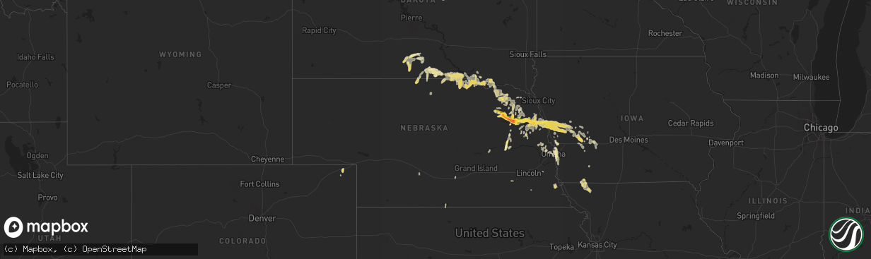
Hail Map in Nebraska on September 22, 2015
The weather event in Nebraska on September 22, 2015 includes Hail map. 10 states and 180 cities were impacted and suffered possible damage. The total estimated number of properties impacted is 10,013.
Want more than just the map?
Turn this storm into a full workflow.
- Owner + property data so you know who to knock
- OnDemand branded weather history reports to win the "did we even have hail?" argument
- RoofTrace estimate so reps stop guessing numbers at the door
Bought this map? Upgrade within 7 days and we'll credit the $230. (10-15 min setup call)
Hail
10,013
Estimated number of impacted properties by a 1.00" hail or larger3,191
Estimated number of impacted properties by a 1.75" hail or larger816
Estimated number of impacted properties by a 2.50" hail or largerStorm reports in Nebraska
Nebraska
| Date | Description |
|---|---|
| 09/22/20151:30 PM CDT | A local report indicates 1.50 inch wind near 2 WSW BANCROFT |
| 09/22/201511:35 AM CDT | A local report indicates 1.00 inch wind near 5 SSW PENDER |
| 09/22/201511:15 AM CDT | A local report indicates 1.00 inch wind near 4 NE WISNER |
| 09/22/201511:05 AM CDT | Report received via social media. Size estimated from pictures. Significant damage to roof and siding. |
| 09/22/201511:01 AM CDT | Produced drifts of hail on highway 275. |
| 09/22/201510:55 AM CDT | A local report indicates 1.75 inch wind near 5 NE STANTON |
| 09/22/201510:40 AM CDT | Ground is white with hail |
| 09/22/201510:30 AM CDT | A local report indicates 1.50 inch wind near 7 WNW PILGER |
| 09/22/201510:03 AM CDT | A local report indicates 1.25 inch wind near 2 NE NORFOLK |
| 09/22/201510:02 AM CDT | A local report indicates 1.75 inch wind near 4 ENE NORFOLK |
| 09/22/20159:50 AM CDT | A local report indicates 1.00 inch wind near 2 NE NORFOLK |
| 09/22/20159:12 AM CDT | A local report indicates 1.75 inch wind near PIERCE |
| 09/22/20159:08 AM CDT | Ground is covered with hail...leaves being stripped from trees. |
| 09/22/20154:39 AM CDT | Measured at eppley airfield |
| 09/21/201510:58 PM CDT | A local report indicates 1.00 inch wind near 5 N WAUSA |
| 09/21/201510:08 PM CDT | A local report indicates 1.00 inch wind near 3 NNW COLUMBUS |
| 09/21/201510:07 PM CDT | Mostly dime size with some 1 inch diameter at the hospital. |
| 09/21/20157:15 PM CDT | A tree was blown down onto a roof in the northeast part of the city. |
| 09/21/20157:14 PM CDT | A local report indicates 60 MPH wind near NORTH PLATTE |
| 09/21/20157:10 PM CDT | Part of a roof was blown off of a mobile home in the southeast part of the city. |
All States Impacted by Hail Map on September 22, 2015
Cities Impacted by Hail Map on September 22, 2015
- Pilger, NE
- Pierce, NE
- Stanton, NE
- Hoskins, NE
- Wisner, NE
- Norfolk, NE
- Wagner, SD
- Woodbine, IA
- Pisgah, IA
- Moorhead, IA
- Dunlap, IA
- Colome, SD
- Winner, SD
- Creston, NE
- Leigh, NE
- Long Pine, NE
- Blair, NE
- Arlington, NE
- Kennard, NE
- Exira, IA
- Grenville, NM
- Pender, NE
- Rosalie, NE
- Bancroft, NE
- Columbus, NE
- Bennington, NE
- Omaha, NE
- Defuniak Springs, FL
- Lynch, NE
- Witten, SD
- Highmore, SD
- Orient, SD
- Brock, NE
- Julian, NE
- Ute, IA
- West Point, NE
- Lyons, NE
- Beemer, NE
- Oakland, NE
- Soldier, IA
- Winside, NE
- Castana, IA
- Tekamah, NE
- Blencoe, IA
- Little Sioux, IA
- Decatur, NE
- Onawa, IA
- Walthill, NE
- Dow City, IA
- Folsom, NM
- Bonesteel, SD
- Brayton, IA
- Springview, NE
- Sparks, NE
- Wood, SD
- Bellwood, NE
- Council Bluffs, IA
- Crescent, IA
- Logan, IA
- Clarinda, IA
- Wendell, MN
- Dallas, SD
- Manilla, IA
- Marne, IA
- Kirkman, IA
- Elk Horn, IA
- Harlan, IA
- Kimballton, IA
- Atlantic, IA
- Carter Lake, IA
- Mission, SD
- Avon, SD
- Dante, SD
- Carroll, NE
- Belden, NE
- Coleridge, NE
- Laurel, NE
- Naper, NE
- Craig, NE
- Dodge, NE
- Fremont, NE
- Newcastle, NE
- Gregory, SD
- Amistad, NM
- Walnut, IA
- Mclean, NE
- Sedgwick, CO
- Missouri Valley, IA
- Honey Creek, IA
- Friend, NE
- Florence, AZ
- Coolidge, AZ
- Wausa, NE
- Fairfax, SD
- Bloomfield, NE
- Nodaway, IA
- Corning, IA
- Elbow Lake, MN
- White River, SD
- Niobrara, NE
- Okreek, SD
- Audubon, IA
- Irwin, IA
- Hamlin, IA
- Manning, IA
- Adair, IA
- Mills, NE
- Clearmont, MO
- Saint Charles, SD
- Herrick, SD
- Atkinson, NE
- Burke, SD
- Spencer, NE
- Butte, NE
- Pickering, MO
- Braddyville, IA
- Maryville, MO
- Burlington Junction, MO
- Hopkins, MO
- Bedford, IA
- Elmo, MO
- Earling, IA
- Defiance, IA
- Hartington, NE
- Osmond, NE
- Plainview, NE
- Langford, SD
- Crofton, NE
- Albuquerque, NM
- Anita, IA
- Bristow, NE
- Randolph, NE
- Lake Andes, SD
- Oneill, NE
- Tabor, SD
- Springfield, SD
- Denison, IA
- Macy, NE
- Arion, IA
- Tyndall, SD
- Magnet, NE
- Panama, IA
- Roswell, NM
- Fergus Falls, MN
- Wayne, NE
- Wakefield, NE
- Westville, FL
- Snyder, NE
- Scribner, NE
- Phillipsburg, KS
- Republican City, NE
- Cozad, NE
- Talmage, NE
- Nebraska City, NE
- Peru, NE
- Auburn, NE
- Avondale, CO
- Kearney, NE
- Pacific Junction, IA
- Dalton, MN
- Jarales, NM
- Fullerton, NE
- Ovid, CO
- Glenwood, IA
- Concord, NE
- Bellevue, NE
- Cortland, NE
- Pickrell, NE
- Howells, NE
- Valley, NE
- Elkhorn, NE
- Elmwood, NE
- Casey, IA
- Washington, NE
- Fort Ripley, MN
- Dorchester, NE
- Mondamin, IA
- Britton, SD
- Platte Center, NE
- Tucson, AZ


