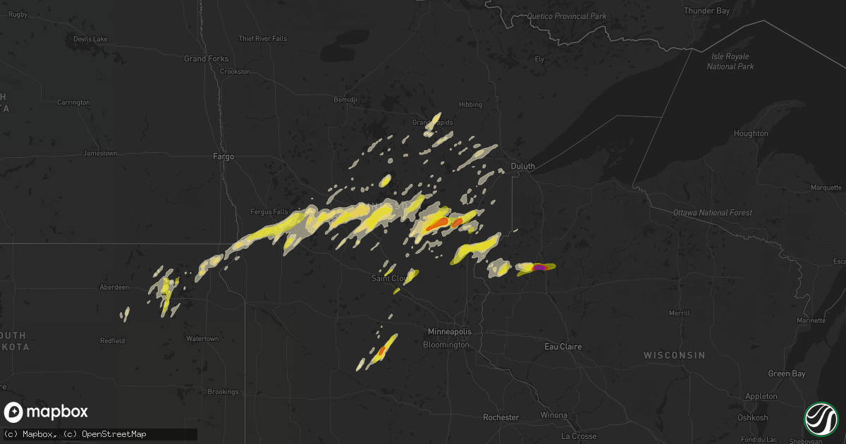
Hail Map in Minnesota on September 21, 2017
Get this storm
September 21 map
$229
one time, instant access
Download today. No call, no setup
Keep the $229
Bought the map and want the full workflow? Apply the entire $229 to a subscription within 7 days. None of it is wasted.
Every map, not just this one
This buys you this map. Subscription and you get every map we run, in the markets you choose from a few cities to whole states to nationwide. Plus real-time alerts the moment a storm fires.
Contact data
Name, contact info, occupancy, even credit band for addresses in the footprint. You go from where it hit to who to call.
Become the source they trust
Unlimited branding weather history reports on demand. You already have the documented answer ready for the property owner, and you are the one who showed up with it.
Property data and RoofTrace estimates
Pull up any address you have got, its value and the exact code rules for that jurisdiction, straight from One Click Code. Then RoofTrace estimates the squares, pitch, and roof value, priced the way you price.
Storm reports in Minnesota
Minnesota
| Date | Description |
|---|---|
| 09/21/20176:55 AM CDT | Multiple trees knocked down onto power lines. Time estimated by radar. |
| 09/21/20176:36 AM CDT | Few trees knocked down onto power lines. Time estimated by radar. |
| 09/21/20176:15 AM CDT | The average size of hail stones was the size of dimes. |
| 09/21/20176:12 AM CDT | Few trees down on highway 73 west of moose lake. Time estimated by radar. |
| 09/21/20176:08 AM CDT | The thunderstorm winds knocked down four trees in the kettle river area. |
| 09/21/20176:06 AM CDT | Few trees knocked down blocking road near state 200 and state 6 in remer. Time estimated by radar. |
| 09/21/20176:03 AM CDT | Few trees down on highway 18 between mcgrath and finlayson. Time estimated by radar. |
| 09/21/20175:33 AM CDT | Multiple trees and power lines knocked down. Time estimated from radar. |
| 09/21/20175:30 AM CDT | Reported at chiminising district on se corner of lake mille lacs. |
| 09/21/20175:20 AM CDT | Few trees knocked down blocking state highway 87 west of backus. Time estimated by radar. |
| 09/21/20175:07 AM CDT | Few trees down partially blocking highway 169 near garrison. Time estimated by radar. |
| 09/21/20174:56 AM CDT | Few trees knocked down in the city of brainerd. Time estimated by radar. In addition... The crow wing county sheriff reports widespread tree damage throughout crow wing |
| 09/21/20174:10 AM CDT | A few quarter to half dollar sized hail and very heavy rain. |
| 09/21/20173:30 AM CDT | Hail reported along interstate 94 near the otter tail county line. |
| 09/21/20173:25 AM CDT | Cupola blown off a barn roof. In addition... Parts of the barn siding blown off. Time estimated by radar. |
| 09/21/20173:21 AM CDT | The winds knocked down large branches. |
| 09/21/20173:14 AM CDT | Hail and very heavy rains. |
All States Impacted by Hail Map on September 21, 2017
Cities Impacted by Hail Map on September 21, 2017
- Onamia, MN
- Long Prairie, MN
- Swanville, MN
- Valdosta, GA
- Grand Rapids, MN
- Portland, MI
- Langford, SD
- Crystal City, TX
- Bovey, MN
- Coleraine, MN
- San Ygnacio, TX
- Falls City, TX
- Pleasanton, TX
- Glencoe, MN
- Bristol, SD
- Pierpont, SD
- Webster, SD
- Cushing, MN
- Randall, MN
- Fort Ripley, MN
- Millen, GA
- Middleville, MI
- Hastings, MI
- Aitkin, MN
- Brainerd, MN
- Garrison, MN
- Deerwood, MN
- Kettle River, MN
- Eagle Bend, MN
- Outing, MN
- Remer, MN
- Frederic, WI
- Luck, WI
- Shell Lake, WI
- Barronett, WI
- Chipley, FL
- Kerrick, MN
- Swartz Creek, MI
- Durand, MI
- Lennon, MI
- Flushing, MI
- Merrifield, MN
- Isle, MN
- Hackensack, MN
- Wahkon, MN
- Rio Grande City, TX
- Floodwood, MN
- Brookston, MN
- Tamarack, MN
- Alborn, MN
- Saginaw, MN
- Wright, MN
- Saint Stephen, SC
- Pineville, SC
- Roma, TX
- Verndale, MN
- Sebeka, MN
- Wadena, MN
- Hewitt, MN
- Greenville, FL
- Perry, FL
- Nashua, MN
- Wendell, MN
- Rosholt, SD
- Ashby, MN
- Vining, MN
- Dalton, MN
- Elbow Lake, MN
- Wheaton, MN
- Tintah, MN
- Battle Lake, MN
- Clitherall, MN
- Browerville, MN
- Baxter, MN
- Pillager, MN
- Wrightsville, GA
- Winthrop, MN
- Winsted, MN
- Lester Prairie, MN
- Stewart, MN
- Brownton, MN
- Gibbon, MN
- Silver Lake, MN
- Grantsburg, WI
- Grasston, MN
- Pine City, MN
- Hinckley, MN
- Brook Park, MN
- Braham, MN
- Danbury, WI
- Durham, NC
- Creedmoor, NC
- Wake Forest, NC
- Milaca, MN
- Panama City, FL
- Sawyer, MN
- Barnum, MN
- Cloquet, MN
- Cromwell, MN
- Staples, MN
- Bertha, MN
- Clarissa, MN
- Motley, MN
- Henning, MN
- Parkers Prairie, MN
- Hawkinsville, GA
- Pineview, GA
- Swainsboro, GA
- Beeville, TX
- Three Rivers, TX
- Ogilvie, MN
- Lowell, MI
- Clarksville, MI
- Sandstone, MN
- Foley, MN
- Sisseton, SD
- Peever, SD
- New Effington, SD
- Killen, AL
- Altha, FL
- Hutchinson, MN
- Dassel, MN
- Amite, LA
- Ebro, FL
- Burtrum, MN
- Brunson, SC
- Evansville, MN
- Pewamo, MI
- Westphalia, MI
- McGrath, MN
- Roslyn, SD
- Graceville, FL
- Lakemont, GA
- Saint Johns, MI
- Round O, SC
- Lake Odessa, MI
- Dewitt, MI
- Lansing, MI
- Finlayson, MN
- Conover, OH
- Saint Paris, OH
- Brandon, MN
- Pine River, MN
- Adams Run, SC
- Mellette, SD
- Brentford, SD
- Conde, SD
- Warba, MN
- Burt, MI
- Henriette, MN
- Mora, MN
- Ponce De Leon, FL
- Vernon, FL
- Little Falls, MN
- Hill City, MN
- Troy, OH
- Garfield, MN
- Miltona, MN
- Aldrich, MN
- Siren, WI
- Alamo, GA
- Brilliant, AL
- Hamilton, AL
- Guin, AL
- Smithville, GA
- Leesburg, GA
- Hillman, MN
- Barrett, MN
- Askov, MN
- Willow River, MN
- Mcgregor, MN
- Palisade, MN
- Fairfax, MN
- Cushing, WI
- Ashley, MI
- Cohasset, MN
- Kingstree, SC
- Andrews, SC
- Salters, SC
- Nesmith, SC
- Fremont, NC
- Kenly, NC
- Saint Stephen, MN
- Saint Joseph, MN
- Sartell, MN
- Rice, MN
- Gibson, LA
- Freeport, MI
- Fergus Falls, MN
- Clear Lake, MN
- Clearwater, MN
- Pensacola, FL
- West Milton, OH
- Pikeville, NC
- Nevis, MN
- Backus, MN
- Esko, MN
- Pierz, MN
- Battle Creek, MI
- Georgetown, SC
- Hemingway, SC
- Pequot Lakes, MN
- Crosslake, MN
- Eastman, GA
- Buffalo Lake, MN
- Swan River, MN
- Jacobson, MN
- Cokato, MN
- Glenwood, GA
- Alexandria, MN
- Norcross, MN
- Campbell, MN
- Hoffman, MN
- Grey Eagle, MN
- Osakis, MN
- Underwood, MN
- Deer Creek, MN
- Bancroft, MI
- Owosso, MI
- Fowlerville, MI
- Quitman, GA
- Cochran, GA
- Perry, MI
- Clinton, NC
- Clarksville, FL
- Ridgeville, SC
- Moose Lake, MN
- Cottondale, FL
- Kalamazoo, MI
- Richland, MI
- Freeport, FL
- Urbana, OH
- Lane, SC
- Walker, MN
- Fairmount, ND
- Hankinson, ND
- Eden, SD
- New York Mills, MN
- Madison, FL
- Longville, MN
- Nichols, SC
- Lake View, SC
- Andover, SD
- Bradley, SD
- Britton, SD
- New Lothrop, MI
- Corunna, MI
- Grenville, SD
- Manchester, TN
- Floresville, TX
- Meadowlands, MN
- Beardsley, MN
- Browns Valley, MN
- Seven Springs, NC
- Avon, MN
- Slidell, LA
- Milan, GA
- Chauncey, GA
- McRae Helena, GA
- Sunfield, MI
- Lucama, NC
- Kite, GA
- Sturgeon Lake, MN
- Princeton, NC
- Saint Cloud, MN
- Princeton, MN
- Eagle, MI
- Grand Ledge, MI
- Lyons, MI
- Manning, SC
- Magnolia, NC
- Rose Hill, NC
- Quincy, FL
- Swatara, MN
- Morrice, MI
- Marianna, FL
- Saranac, MI
- Woodland, MI
- Alto, MI
- Abbeville, GA
- Conway, SC
- Vernon, MI
- Leslie, MI
- Hector, MN
- Stone Mountain, GA
- Pink Hill, NC
- Sauk Rapids, MN
- Bartow, GA
- Lamont, FL
- McEwen, TN
- Fowler, MI
- Mullins, SC
- Fairmont, NC
- Crosby, MN
- Ironton, MN
- Ovid, MI
- Laingsburg, MI
- Morrison, TN
- New Bern, NC
- Oak Park, MN
- Cumberland, WI
- Birchwood, WI
- Sarona, WI
- Dilley, TX


