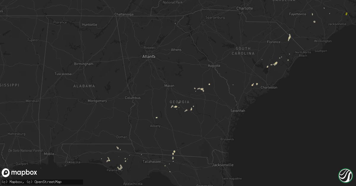
Hail Map in Georgia on September 21, 2017
Get this storm
September 21 map
$229
one time, instant access
Download today. No call, no setup
Keep the $229
Bought the map and want the full workflow? Apply the entire $229 to a subscription within 7 days. None of it is wasted.
Every map, not just this one
This buys you this map. Subscription and you get every map we run, in the markets you choose from a few cities to whole states to nationwide. Plus real-time alerts the moment a storm fires.
Contact data
Name, contact info, occupancy, even credit band for addresses in the footprint. You go from where it hit to who to call.
Become the source they trust
Unlimited branding weather history reports on demand. You already have the documented answer ready for the property owner, and you are the one who showed up with it.
Property data and RoofTrace estimates
Pull up any address you have got, its value and the exact code rules for that jurisdiction, straight from One Click Code. Then RoofTrace estimates the squares, pitch, and roof value, priced the way you price.
Storm reports in Georgia
Georgia
| Date | Description |
|---|---|
| 09/21/20176:44 PM CDT | Mulitple trees and powerlines down at intersection of highway 257 and noble rd. 1 house had some damage from tree. Time estimated from radar. |
| 09/21/20176:39 PM CDT | Tree down on hwy 257 and folds rd nw of pineview |
| 09/21/20175:29 PM CDT | 2 trees down on hardy rd near dubois church rd |
| 09/21/20175:29 PM CDT | Tree down off hwy 280 in milan |
| 09/21/20175:29 PM CDT | Tree down on gresston baptist rd near hardy rd |
| 09/21/20173:35 PM CDT | Tree down on hollywood church rd. Time estimated from radar. |
| 09/20/20177:25 PM CDT | Tree across cracen road at louisville court. Time estimated based on radar. |
| 09/20/20177:23 PM CDT | Multiple trees and powerlines down as well as one power pole down across highway 17 between gracen road and keith road. Time estimated based on radar. |
All States Impacted by Hail Map on September 21, 2017
Cities Impacted by Hail Map on September 21, 2017
- Onamia, MN
- Long Prairie, MN
- Swanville, MN
- Valdosta, GA
- Grand Rapids, MN
- Portland, MI
- Langford, SD
- Crystal City, TX
- Bovey, MN
- Coleraine, MN
- San Ygnacio, TX
- Falls City, TX
- Pleasanton, TX
- Glencoe, MN
- Bristol, SD
- Pierpont, SD
- Webster, SD
- Cushing, MN
- Randall, MN
- Fort Ripley, MN
- Millen, GA
- Middleville, MI
- Hastings, MI
- Aitkin, MN
- Brainerd, MN
- Garrison, MN
- Deerwood, MN
- Kettle River, MN
- Eagle Bend, MN
- Outing, MN
- Remer, MN
- Frederic, WI
- Luck, WI
- Shell Lake, WI
- Barronett, WI
- Chipley, FL
- Kerrick, MN
- Swartz Creek, MI
- Durand, MI
- Lennon, MI
- Flushing, MI
- Merrifield, MN
- Isle, MN
- Hackensack, MN
- Wahkon, MN
- Rio Grande City, TX
- Floodwood, MN
- Brookston, MN
- Tamarack, MN
- Alborn, MN
- Saginaw, MN
- Wright, MN
- Saint Stephen, SC
- Pineville, SC
- Roma, TX
- Verndale, MN
- Sebeka, MN
- Wadena, MN
- Hewitt, MN
- Greenville, FL
- Perry, FL
- Nashua, MN
- Wendell, MN
- Rosholt, SD
- Ashby, MN
- Vining, MN
- Dalton, MN
- Elbow Lake, MN
- Wheaton, MN
- Tintah, MN
- Battle Lake, MN
- Clitherall, MN
- Browerville, MN
- Baxter, MN
- Pillager, MN
- Wrightsville, GA
- Winthrop, MN
- Winsted, MN
- Lester Prairie, MN
- Stewart, MN
- Brownton, MN
- Gibbon, MN
- Silver Lake, MN
- Grantsburg, WI
- Grasston, MN
- Pine City, MN
- Hinckley, MN
- Brook Park, MN
- Braham, MN
- Danbury, WI
- Durham, NC
- Creedmoor, NC
- Wake Forest, NC
- Milaca, MN
- Panama City, FL
- Sawyer, MN
- Barnum, MN
- Cloquet, MN
- Cromwell, MN
- Staples, MN
- Bertha, MN
- Clarissa, MN
- Motley, MN
- Henning, MN
- Parkers Prairie, MN
- Hawkinsville, GA
- Pineview, GA
- Swainsboro, GA
- Beeville, TX
- Three Rivers, TX
- Ogilvie, MN
- Lowell, MI
- Clarksville, MI
- Sandstone, MN
- Foley, MN
- Sisseton, SD
- Peever, SD
- New Effington, SD
- Killen, AL
- Altha, FL
- Hutchinson, MN
- Dassel, MN
- Amite, LA
- Ebro, FL
- Burtrum, MN
- Brunson, SC
- Evansville, MN
- Pewamo, MI
- Westphalia, MI
- McGrath, MN
- Roslyn, SD
- Graceville, FL
- Lakemont, GA
- Saint Johns, MI
- Round O, SC
- Lake Odessa, MI
- Dewitt, MI
- Lansing, MI
- Finlayson, MN
- Conover, OH
- Saint Paris, OH
- Brandon, MN
- Pine River, MN
- Adams Run, SC
- Mellette, SD
- Brentford, SD
- Conde, SD
- Warba, MN
- Burt, MI
- Henriette, MN
- Mora, MN
- Ponce De Leon, FL
- Vernon, FL
- Little Falls, MN
- Hill City, MN
- Troy, OH
- Garfield, MN
- Miltona, MN
- Aldrich, MN
- Siren, WI
- Alamo, GA
- Brilliant, AL
- Hamilton, AL
- Guin, AL
- Smithville, GA
- Leesburg, GA
- Hillman, MN
- Barrett, MN
- Askov, MN
- Willow River, MN
- Mcgregor, MN
- Palisade, MN
- Fairfax, MN
- Cushing, WI
- Ashley, MI
- Cohasset, MN
- Kingstree, SC
- Andrews, SC
- Salters, SC
- Nesmith, SC
- Fremont, NC
- Kenly, NC
- Saint Stephen, MN
- Saint Joseph, MN
- Sartell, MN
- Rice, MN
- Gibson, LA
- Freeport, MI
- Fergus Falls, MN
- Clear Lake, MN
- Clearwater, MN
- Pensacola, FL
- West Milton, OH
- Pikeville, NC
- Nevis, MN
- Backus, MN
- Esko, MN
- Pierz, MN
- Battle Creek, MI
- Georgetown, SC
- Hemingway, SC
- Pequot Lakes, MN
- Crosslake, MN
- Eastman, GA
- Buffalo Lake, MN
- Swan River, MN
- Jacobson, MN
- Cokato, MN
- Glenwood, GA
- Alexandria, MN
- Norcross, MN
- Campbell, MN
- Hoffman, MN
- Grey Eagle, MN
- Osakis, MN
- Underwood, MN
- Deer Creek, MN
- Bancroft, MI
- Owosso, MI
- Fowlerville, MI
- Quitman, GA
- Cochran, GA
- Perry, MI
- Clinton, NC
- Clarksville, FL
- Ridgeville, SC
- Moose Lake, MN
- Cottondale, FL
- Kalamazoo, MI
- Richland, MI
- Freeport, FL
- Urbana, OH
- Lane, SC
- Walker, MN
- Fairmount, ND
- Hankinson, ND
- Eden, SD
- New York Mills, MN
- Madison, FL
- Longville, MN
- Nichols, SC
- Lake View, SC
- Andover, SD
- Bradley, SD
- Britton, SD
- New Lothrop, MI
- Corunna, MI
- Grenville, SD
- Manchester, TN
- Floresville, TX
- Meadowlands, MN
- Beardsley, MN
- Browns Valley, MN
- Seven Springs, NC
- Avon, MN
- Slidell, LA
- Milan, GA
- Chauncey, GA
- McRae Helena, GA
- Sunfield, MI
- Lucama, NC
- Kite, GA
- Sturgeon Lake, MN
- Princeton, NC
- Saint Cloud, MN
- Princeton, MN
- Eagle, MI
- Grand Ledge, MI
- Lyons, MI
- Manning, SC
- Magnolia, NC
- Rose Hill, NC
- Quincy, FL
- Swatara, MN
- Morrice, MI
- Marianna, FL
- Saranac, MI
- Woodland, MI
- Alto, MI
- Abbeville, GA
- Conway, SC
- Vernon, MI
- Leslie, MI
- Hector, MN
- Stone Mountain, GA
- Pink Hill, NC
- Sauk Rapids, MN
- Bartow, GA
- Lamont, FL
- McEwen, TN
- Fowler, MI
- Mullins, SC
- Fairmont, NC
- Crosby, MN
- Ironton, MN
- Ovid, MI
- Laingsburg, MI
- Morrison, TN
- New Bern, NC
- Oak Park, MN
- Cumberland, WI
- Birchwood, WI
- Sarona, WI
- Dilley, TX


