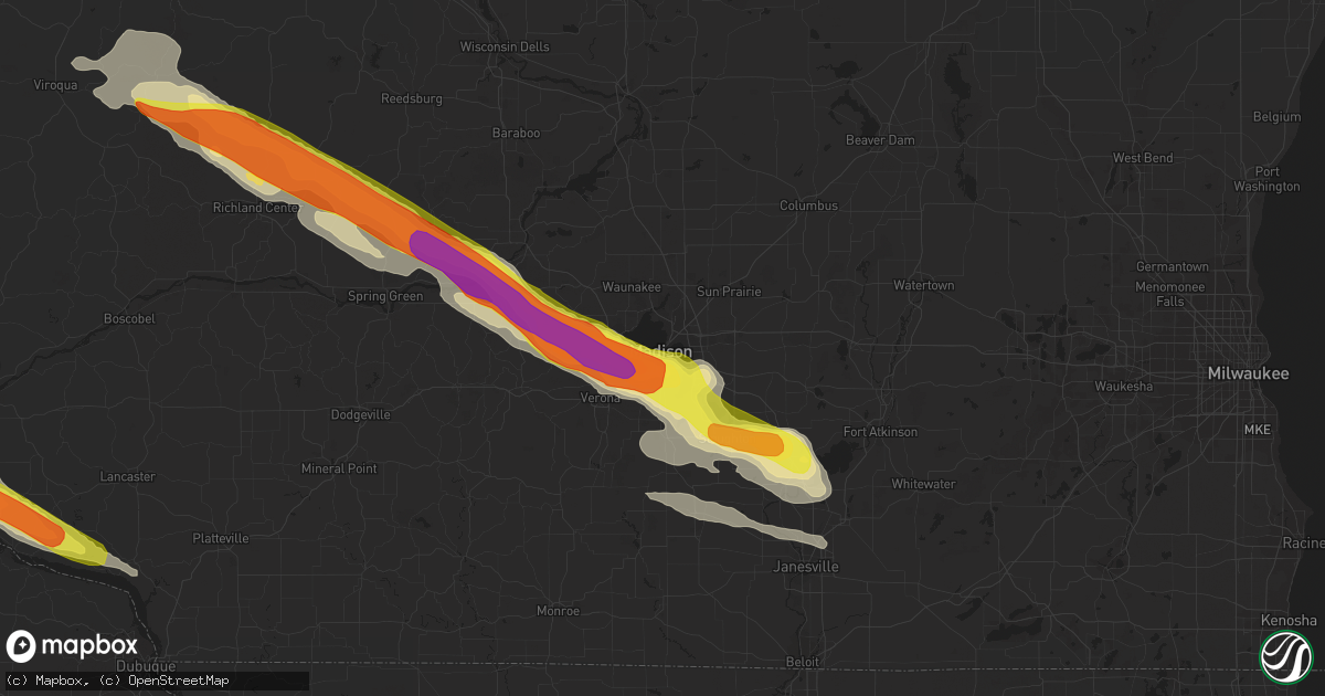
Hail Map in Madison, WI on September 19, 2016
Get this storm
September 19 map
$229
one time, instant access
Download today. No call, no setup
Keep the $229
Bought the map and want the full workflow? Apply the entire $229 to a subscription within 7 days. None of it is wasted.
Every map, not just this one
This buys you this map. Subscription and you get every map we run, in the markets you choose from a few cities to whole states to nationwide. Plus real-time alerts the moment a storm fires.
Contact data
Name, contact info, occupancy, even credit band for addresses in the footprint. You go from where it hit to who to call.
Become the source they trust
Unlimited branding weather history reports on demand. You already have the documented answer ready for the property owner, and you are the one who showed up with it.
Property data and RoofTrace estimates
Pull up any address you have got, its value and the exact code rules for that jurisdiction, straight from One Click Code. Then RoofTrace estimates the squares, pitch, and roof value, priced the way you price.
Storm reports in Madison, WI
Madison, WI
| Date | Description |
|---|---|
| 09/19/20164:20 PM CDT | . |
| 09/19/20164:20 PM CDT | . |
| 09/19/20164:17 PM CDT | . |
| 09/19/20164:17 PM CDT | . |
| 09/19/20164:15 PM CDT | . |
| 09/19/20164:15 PM CDT | 1 1/2 inch diameter hail near intersection of schroeder road and whitney way. Hail ended around 425 pm. |
| 09/19/20164:15 PM CDT | Hail ranging from 1.75 to 2.2 inches in diameter. . |
| 09/19/20164:13 PM CDT | . |
| 09/19/20164:12 PM CDT | . |
| 09/19/20164:10 PM CDT | . |
| 09/19/20164:10 PM CDT | 1 1/2 inch diameter hail in the country grove area on the west side of madison. Hail started around 410 pm and ended around 420 pm. |
| 09/19/20164:05 PM CDT | . |
All States Impacted by Hail Map on September 19, 2016
All Cities Impacted by Hail Map on September 19, 2016
- Deerfield, WI
- Cambridge, WI
- Cottage Grove, WI
- San Mateo, FL
- Prairie Du Chien, WI
- Orange, TX
- Spring Green, WI
- Black Earth, WI
- Middleton, WI
- Hillsboro, WI
- Richland Center, WI
- Loganville, WI
- Cross Plains, WI
- Verona, WI
- Mount Horeb, WI
- Oregon, WI
- Mazomanie, WI
- Hillpoint, WI
- Madison, WI
- Plain, WI
- Viola, WI
- Sauk City, WI
- Cazenovia, WI
- La Farge, WI
- Corydon, IA
- Danielsville, GA
- Polo, MO
- Mayville, WI
- Monroe, WI
- Gratiot, WI
- South Wayne, WI
- Mineral Point, WI
- Woodford, WI
- Darlington, WI
- Argyle, WI
- Otley, IA
- Luana, IA
- Elgin, IA
- Cassville, WI
- Saint Olaf, IA
- Farmersburg, IA
- Glen Haven, WI
- Postville, IA
- Guttenberg, IA
- Garnavillo, IA
- Monroe, IA
- Jamesport, MO
- Colesburg, IA
- Chariton, IA
- Williamson, IA
- Edgerton, WI
- Stoughton, WI
- Eden, WI
- Campbellsport, WI
- Fond Du Lac, WI
- Gallatin, MO
- Lodi, WI
- Waukon, IA
- Fort Pierce, FL
- Allerton, IA
- Princeton, MO
- Newtown, MO
- Lacona, IA
- Pollock, MO
- Unionville, MO
- Lucerne, MO
- Seymour, IA
- Plano, IA
- Powersville, MO
- Humeston, IA
- Millerton, IA
- Russell, IA
- Mercer, MO
- Milan, MO
- Lineville, IA
- Melrose, IA
- Clio, IA
- Promise City, IA
- Belgium, WI
- Fredonia, WI
- Rayville, MO
- Cowgill, MO
- Trenton, MO
- Jameson, MO
- Lock Springs, MO
- Lawson, MO
- Hamilton, MO
- Turney, MO
- Kingston, MO
- Breckenridge, MO
- Chillicothe, MO
- Gilman City, MO
- Kidder, MO
- Lathrop, MO
- Cameron, MO
- Bloomington, WI
- Janesville, WI
- Milton, WI
- Evansville, WI
- Brooklyn, WI
- Wisconsin Dells, WI
- Viroqua, WI
- Livingston, WI
- Toledo, IA
- Garber, IA
- Elkader, IA
- Potosi, WI
- Pella, IA
- Arena, WI
- Lone Rock, WI
- Mcfarland, WI
- Kinards, SC
- Whitmire, SC
- Newberry, SC
- Westby, WI
- Chaseburg, WI
- Richmond, TX
- Stitzer, WI
- Portage, WI
- Blue Mounds, WI
- Barneveld, WI
- Allenton, WI
- Kewaskum, WI
- Prairie City, IA
- Sulphur, LA
- Hackberry, LA
- Clermont, IA
- Bagley, WI
- Harpers Ferry, IA
- Marquette, IA
- Wauzeka, WI
- McGregor, IA
- Monona, IA
- Ackworth, IA
- Milo, IA
- Fort Atkinson, WI
- Reeseville, WI
- Watertown, WI
- Juneau, WI
- Blanchardville, WI
- New Glarus, WI
- Adell, WI
- Brownsville, WI
- Spickard, MO
- Melbourne, FL
- Hollandale, WI
- Beaver Dam, WI
- Randolph, WI
- Belleville, WI
- Lancaster, WI
- Jefferson, WI
- Union, SC
- Mount Hope, WI
- Decorah, IA
- Lansing, IA
- Platteville, WI
- Rewey, WI
- West Bend, WI
- Prairie Du Sac, WI
- Cascade, WI
- Waterville, IA
- Castalia, IA


