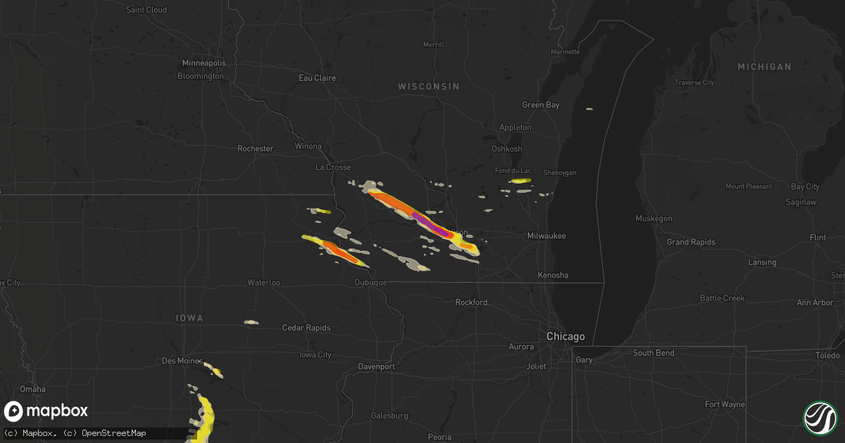
Hail Map on September 19, 2016
Get this storm
September 19 map
$229
one time, instant access
Download today. No call, no setup
Keep the $229
Bought the map and want the full workflow? Apply the entire $229 to a subscription within 7 days. None of it is wasted.
Every map, not just this one
This buys you this map. Subscription and you get every map we run, in the markets you choose from a few cities to whole states to nationwide. Plus real-time alerts the moment a storm fires.
Contact data
Name, contact info, occupancy, even credit band for addresses in the footprint. You go from where it hit to who to call.
Become the source they trust
Unlimited branding weather history reports on demand. You already have the documented answer ready for the property owner, and you are the one who showed up with it.
Property data and RoofTrace estimates
Pull up any address you have got, its value and the exact code rules for that jurisdiction, straight from One Click Code. Then RoofTrace estimates the squares, pitch, and roof value, priced the way you price.
States Impacted by Hail Map on September 19, 2016
Storm reports
Florida
| Date | Description |
|---|---|
| 09/19/20163:28 PM CDT | Deerfield beach sheriffs office reports multiple power lines down near 4400 n powerline rd at 439 pm. Event time estimated at 428 pm based on doppler radar. |
| 09/19/20163:15 PM CDT | Deerfield beach sheriffs office reported a downed powerline at 415 pm near intersection of military trail and sw 10th street |
| 09/19/20163:15 PM CDT | Recieved reports through social media of several trees being knocked down onto parked cars in deerfield beach at 1350 east newport center drive. |
| 09/19/20163:12 PM CDT | Member of the media called to report medium-sized tree uprooted and fallen due to strong thunderstorm wind gusts at 412 pm near intersection of hillsboro blvd and sw 12 |
Georgia
| Date | Description |
|---|---|
| 09/19/20166:20 PM CDT | Several trees were blown down in and around the danielsville area. |
Iowa
| Date | Description |
|---|---|
| 09/19/20166:24 PM CDT | Wayne county em reported multiple pole barns blown over. Debris from pole barns blew into and downed nearby power line. Time estimated from radar. |
| 09/19/20166:21 PM CDT | Wayne county em reported pole barn downed from strong winds. Time and location estimated from radar. Delayed report. . |
| 09/19/20165:33 PM CDT | Report of roof off shed and attached garage damaged on southern edge of chariton. Time and location estimated from radar. |
| 09/19/20165:30 PM CDT | Report of two instances of a large tree downed onto a house in chariton. Time and location estimated from radar. |
| 09/19/20163:19 PM CDT | Grape to golfball sized. |
| 09/19/20163:14 PM CDT | . |
South Carolina
| Date | Description |
|---|---|
| 09/19/20166:37 PM CDT | Newberry county dispatch reports trees and power lines down in the city of newberry. |
| 09/18/20168:27 PM CDT | Sc highway patrol reports a tree in roadway on steven campbell road near the intersection with us 1. Time estimated based on radar. . |
| 09/18/20168:21 PM CDT | Tree down along us 1 near richland county line. |
| 09/18/20168:20 PM CDT | Skywarn spotter in the pontiac section of ne columbia reports a tree down along hickory hills trail. |
| 09/18/20168:17 PM CDT | Sc hwy patrol reports a tree in roadway along the 400 block of longtown rd near jilda drive. |
| 09/18/20168:15 PM CDT | Sc hwy patrol reports a tree in roadway along hardscrabble rd near sloan rd in ne columbia. |
| 09/18/20167:59 PM CDT | Lexington police department reported a tree down blocking travel near the intersection of bellewood drive and harmon street. Time estimated based on radar. |
| 09/18/20167:53 PM CDT | Lexington county dispatch reports trees down...one in roadway along s lake dr...other along old chapin rd. |
Wisconsin
| Date | Description |
|---|---|
| 09/19/20164:45 PM CDT | 1 mile north of newville. |
| 09/19/20164:20 PM CDT | . |
| 09/19/20164:20 PM CDT | . |
| 09/19/20164:17 PM CDT | . |
| 09/19/20164:17 PM CDT | . |
| 09/19/20164:15 PM CDT | Hail ranging from 1.75 to 2.2 inches in diameter. . |
| 09/19/20164:15 PM CDT | 1 1/2 inch diameter hail near intersection of schroeder road and whitney way. Hail ended around 425 pm. |
| 09/19/20164:15 PM CDT | . |
| 09/19/20164:13 PM CDT | . |
| 09/19/20164:12 PM CDT | . |
| 09/19/20164:11 PM CDT | 2 inch hail at middleton junction. . |
| 09/19/20164:10 PM CDT | . |
| 09/19/20164:10 PM CDT | 1 1/2 inch diameter hail in the country grove area on the west side of madison. Hail started around 410 pm and ended around 420 pm. |
| 09/19/20164:06 PM CDT | Reported at middleton police station. |
| 09/19/20164:05 PM CDT | . |
| 09/19/20164:05 PM CDT | 1.5-2 inch diameter hail...majority of hailstones were 1.75 inches in diameter. 1.08 inches of rain in 20 minutes. Hail caused damage to car... Home roof... Siding and |
| 09/19/20164:00 PM CDT | . |
| 09/19/20163:25 PM CDT | . |
| 09/19/20163:22 PM CDT | A local report indicates 1.00 inch wind near GLEN HAVEN |
| 09/19/20163:00 PM CDT | Time estimated. |
| 09/19/20162:50 PM CDT | A local report indicates 1.00 inch wind near BLOOM CITY |
Missouri
| Date | Description |
|---|---|
| 09/18/20168:56 PM CDT | Large tree down along linn st. |
| 09/18/20168:56 PM CDT | Multiple tree limbs down along 5th and ellison st. |
| 09/18/20168:26 PM CDT | Large tree down along linn st. |
| 09/18/20168:26 PM CDT | Multiple tree limbs down along 5th and ellison st. |
| 09/18/20168:26 PM CDT | Numerous trees uprooted through trenton. Roof blown off industrial building and site built building blown down in park |
| 09/18/20168:10 PM CDT | Porch blown off house. |
| 09/18/20167:48 PM CDT | Reported 60mph gusts west of milan. |
| 09/18/20167:20 PM CDT | Several trees down...unknown condition |
| 09/18/20167:20 PM CDT | Several trees down...unknown condition |
| 09/18/20167:12 PM CDT | Powerlines and a few larger limbs down. |
Kansas
| Date | Description |
|---|---|
| 09/18/20168:24 PM CDT | Several trees down...unknown condition |
Cities Impacted by Hail Map on September 19, 2016
- Deerfield, WI
- Cambridge, WI
- Cottage Grove, WI
- San Mateo, FL
- Prairie Du Chien, WI
- Orange, TX
- Spring Green, WI
- Black Earth, WI
- Middleton, WI
- Hillsboro, WI
- Richland Center, WI
- Loganville, WI
- Cross Plains, WI
- Verona, WI
- Mount Horeb, WI
- Oregon, WI
- Mazomanie, WI
- Hillpoint, WI
- Madison, WI
- Plain, WI
- Viola, WI
- Sauk City, WI
- Cazenovia, WI
- La Farge, WI
- Corydon, IA
- Danielsville, GA
- Polo, MO
- Mayville, WI
- Monroe, WI
- Gratiot, WI
- South Wayne, WI
- Mineral Point, WI
- Woodford, WI
- Darlington, WI
- Argyle, WI
- Otley, IA
- Luana, IA
- Elgin, IA
- Cassville, WI
- Saint Olaf, IA
- Farmersburg, IA
- Glen Haven, WI
- Postville, IA
- Guttenberg, IA
- Garnavillo, IA
- Monroe, IA
- Jamesport, MO
- Colesburg, IA
- Chariton, IA
- Williamson, IA
- Edgerton, WI
- Stoughton, WI
- Eden, WI
- Campbellsport, WI
- Fond Du Lac, WI
- Gallatin, MO
- Lodi, WI
- Waukon, IA
- Fort Pierce, FL
- Allerton, IA
- Princeton, MO
- Newtown, MO
- Lacona, IA
- Pollock, MO
- Unionville, MO
- Lucerne, MO
- Seymour, IA
- Plano, IA
- Powersville, MO
- Humeston, IA
- Millerton, IA
- Russell, IA
- Mercer, MO
- Milan, MO
- Lineville, IA
- Melrose, IA
- Clio, IA
- Promise City, IA
- Belgium, WI
- Fredonia, WI
- Rayville, MO
- Cowgill, MO
- Trenton, MO
- Jameson, MO
- Lock Springs, MO
- Lawson, MO
- Hamilton, MO
- Turney, MO
- Kingston, MO
- Breckenridge, MO
- Chillicothe, MO
- Gilman City, MO
- Kidder, MO
- Lathrop, MO
- Cameron, MO
- Bloomington, WI
- Janesville, WI
- Milton, WI
- Evansville, WI
- Brooklyn, WI
- Wisconsin Dells, WI
- Viroqua, WI
- Livingston, WI
- Toledo, IA
- Garber, IA
- Elkader, IA
- Potosi, WI
- Pella, IA
- Arena, WI
- Lone Rock, WI
- Mcfarland, WI
- Kinards, SC
- Whitmire, SC
- Newberry, SC
- Westby, WI
- Chaseburg, WI
- Richmond, TX
- Stitzer, WI
- Portage, WI
- Blue Mounds, WI
- Barneveld, WI
- Allenton, WI
- Kewaskum, WI
- Prairie City, IA
- Sulphur, LA
- Hackberry, LA
- Clermont, IA
- Bagley, WI
- Harpers Ferry, IA
- Marquette, IA
- Wauzeka, WI
- McGregor, IA
- Monona, IA
- Ackworth, IA
- Milo, IA
- Fort Atkinson, WI
- Reeseville, WI
- Watertown, WI
- Juneau, WI
- Blanchardville, WI
- New Glarus, WI
- Adell, WI
- Brownsville, WI
- Spickard, MO
- Melbourne, FL
- Hollandale, WI
- Beaver Dam, WI
- Randolph, WI
- Belleville, WI
- Lancaster, WI
- Jefferson, WI
- Union, SC
- Mount Hope, WI
- Decorah, IA
- Lansing, IA
- Platteville, WI
- Rewey, WI
- West Bend, WI
- Prairie Du Sac, WI
- Cascade, WI
- Waterville, IA
- Castalia, IA