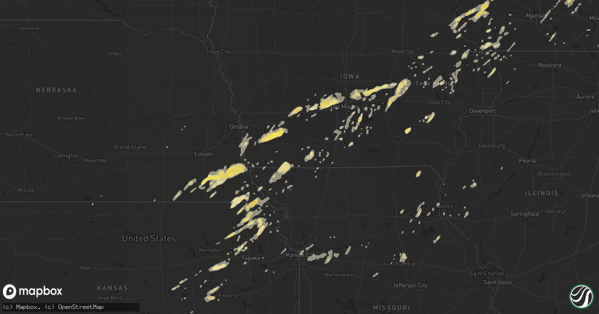
Hail Map in Wisconsin on September 19, 2013
Get this storm
September 19 map
$229
one time, instant access
Download today. No call, no setup
Keep the $229
Bought the map and want the full workflow? Apply the entire $229 to a subscription within 7 days. None of it is wasted.
Every map, not just this one
This buys you this map. Subscription and you get every map we run, in the markets you choose from a few cities to whole states to nationwide. Plus real-time alerts the moment a storm fires.
Contact data
Name, contact info, occupancy, even credit band for addresses in the footprint. You go from where it hit to who to call.
Become the source they trust
Unlimited branding weather history reports on demand. You already have the documented answer ready for the property owner, and you are the one who showed up with it.
Property data and RoofTrace estimates
Pull up any address you have got, its value and the exact code rules for that jurisdiction, straight from One Click Code. Then RoofTrace estimates the squares, pitch, and roof value, priced the way you price.
Storm reports in Wisconsin
Wisconsin
| Date | Description |
|---|---|
| 09/19/20135:59 PM CDT | Large tree limb down - 6 to 8 inch diameter. Time estimated from radar. |
| 09/19/20135:45 PM CDT | Large tree uprooted and many smaller trees snapped. Report from facebook. Time estimated from radar. |
| 09/19/20135:35 PM CDT | Awos measured 53kt wind gust |
| 09/19/20135:30 PM CDT | Delayed report. Scattered reports of trees and power lines downed by thunderstorm wind gusts in an area bounded by evansville and orfordville east to milton...janesvill |
| 09/19/20135:20 PM CDT | Tree branches 4 inch diameter snapped and downed power lines. |
| 09/19/20134:35 PM CDT | Delayed report. Numerous trees and power lines down along a path from northwest of benton to near argyle between 435 pm cdt and 520 pm cdt. |
| 09/19/20134:32 PM CDT | Trees down. |
| 09/19/20134:23 PM CDT | Powerlines down. |
| 09/19/20134:20 PM CDT | Large branches on power lines. |
| 09/19/20134:19 PM CDT | A local report indicates 58 MPH wind near LONE ROCK AIRPORT |
| 09/19/20134:13 PM CDT | Trees down |
| 09/19/20133:47 PM CDT | Trees and power lines down across town. |
| 09/19/201311:55 AM CDT | 1-2 inch diameter tree branches. Also pea-size hail reported. |
| 09/19/201311:51 AM CDT | Pontoon boat and dock it was tied to flipped over on lower clam lake. |
| 09/19/201311:51 AM CDT | 8 inch diameter tree branch down. Time estimated from radar. |
| 09/18/20139:53 PM CDT | Trees blown down and blocking the intersection of hwy 67 and watercress rd. |
| 09/18/20139:45 PM CDT | Delayed report. Trees 2.5 to 3 feet in diameter blown down and blocking the intersection of hwy 28 and hwy 144. |
| 09/18/20139:11 PM CDT | Delayed report. Scattered trees and power lines down in slinger area. Time estimated from radar. |
| 09/18/20139:02 PM CDT | Significant and widespread tree damage starting from druid lake...3 ssw of hartford...to the city of hartford. |
| 09/18/20138:04 PM CDT | A local report indicates 1.00 inch wind near 2 N JANESVILLE |
All States Impacted by Hail Map on September 19, 2013
Cities Impacted by Hail Map on September 19, 2013
- Osceola, IA
- Sterling, NE
- Tecumseh, NE
- Adams, NE
- Hutchinson, MN
- Milo, IA
- Ackworth, IA
- Linden, IA
- Redfield, IA
- Dexter, IA
- Stuart, IA
- Menlo, IA
- Elliott, IA
- Griswold, IA
- Emerson, IA
- Red Oak, IA
- Villisca, IA
- Durham, KS
- Gypsum, KS
- Paxico, KS
- Mechanicsville, IA
- Anamosa, IA
- Morley, IA
- New Virginia, IA
- Hazel Green, WI
- Platteville, WI
- Cuba City, WI
- Wellman, IA
- Washington, IA
- Elk River, MN
- Saint Francis, MN
- Zimmerman, MN
- Vega, TX
- Sabetha, KS
- Oneida, KS
- Seneca, KS
- Fairfax, OK
- Ralston, OK
- Cambridge, MN
- Lismore, MN
- Mount Vernon, IA
- Grant, IA
- Cumberland, IA
- Henderson, IA
- Hastings, IA
- Runnells, IA
- Mitchellville, IA
- Pleasant Hill, IA
- Altoona, IA
- Hector, MN
- Franklin, MN
- Fairfax, MN
- Urbandale, IA
- Waukee, IA
- Grimes, IA
- Clive, IA
- Adel, IA
- Dallas Center, IA
- Kerkhoven, MN
- Harris, MN
- Stanchfield, MN
- Grandy, MN
- Rush City, MN
- Norwich, KS
- Milton, KS
- Viola, KS
- Higgins, TX
- Philadelphia, MO
- Monroe City, MO
- Plymouth, IL
- Colchester, IL
- Wauzeka, WI
- Boscobel, WI
- Truro, IA
- Alva, OK
- Adair, IA
- Exira, IA
- Casey, IA
- Anita, IA
- Cummings, KS
- Marion, KS
- Hillsboro, KS
- Baylis, IL
- Council Grove, KS
- Edgerton, WI
- Janesville, WI
- York, NE
- Murdock, KS
- Cheney, KS
- Prairie Du Chien, WI
- Edna, KS
- Coffeyville, KS
- Topeka, KS
- Auburn, KS
- Diagonal, IA
- Lenox, IA
- Rossville, KS
- Coin, IA
- Perryton, TX
- Mineral Point, WI
- Dodgeville, WI
- Crab Orchard, NE
- San Jon, NM
- Grinnell, IA
- Dora, MO
- Olin, IA
- Cascade, IA
- Monticello, IA
- Center Junction, IA
- Wyoming, IA
- Mound City, MO
- Muscotah, KS
- Valley Falls, KS
- Everest, KS
- Holton, KS
- Lancaster, KS
- Effingham, KS
- Oak Grove, MO
- Wellington, MO
- Lees Summit, MO
- Blue Springs, MO
- Sibley, MO
- Kansas City, MO
- Grain Valley, MO
- Napoleon, MO
- Buckner, MO
- Bates City, MO
- Independence, MO
- Grantsburg, WI
- Kalona, IA
- Riverside, IA
- East Dubuque, IL
- Galena, IL
- Stockton, IL
- Grenville, NM
- Dyersville, IA
- Worthington, IA
- Earlville, IA
- Balko, OK
- Follett, TX
- Laverne, OK
- Booker, TX
- Rocheport, MO
- Hedrick, IA
- Ollie, IA
- Martinsburg, IA
- Fairbury, NE
- Brixey, MO
- Zanoni, MO
- Mount Ayr, IA
- Benton, IA
- Amarillo, TX
- Otterville, MO
- Bunceton, MO
- Dawson, MN
- Freedom, OK
- Anthony, KS
- Attica, KS
- Brewster, MN
- Harper, KS
- Burr, NE
- Filley, NE
- Cook, NE
- Beatrice, NE
- Pickrell, NE
- Lorton, NE
- Julian, NE
- Dunbar, NE
- Nebraska City, NE
- Brock, NE
- Talmage, NE
- Peru, NE
- Syracuse, NE
- Virginia, NE
- Netawaka, KS
- Wetmore, KS
- Powhattan, KS
- Pleasantville, IA
- Lamberton, MN
- Westbrook, MN
- Brookston, IN
- Wolcott, IN
- Fowler, IN
- Remington, IN
- Big Lake, MN
- Becker, MN
- Kouts, IN
- La Crosse, IN
- Burlington Junction, MO
- Grant City, MO
- Allen, KS
- Humboldt, NE
- Stella, NE
- Anoka, MN
- Lake Benton, MN
- Tyler, MN
- Ruthton, MN
- Isanti, MN
- Watseka, IL
- Carlisle, IA
- Morocco, IN
- Donovan, IL
- Epworth, IA
- Farley, IA
- Belle Plaine, IA
- Cottonwood Falls, KS
- Cherryvale, KS
- Newton, IA
- Baxter, IA
- Melbourne, IA
- Laurel, IA
- Warrens, WI
- Black River Falls, WI
- Falls City, NE
- Morrill, KS
- Hiawatha, KS
- Cedar, MN
- Bethel, MN
- Goodland, IN
- Brook, IN
- Kentland, IN
- Mayetta, KS
- Hoyt, KS
- Monticello, MN
- Otley, IA
- Mukwonago, WI
- Waterford, WI
- Big Bend, WI
- Hartford, IA
- Sandstone, MN
- Cokato, MN
- Annandale, MN
- Maple Lake, MN
- Buffalo, MN
- Howard Lake, MN
- Gainesville, MO
- Bakersfield, MO
- Clarkridge, AR
- Gamaliel, AR
- Waterloo, WI
- Juneau, WI
- Reeseville, WI
- Beaver Dam, WI
- Carson, IA
- Malvern, IA
- Cortland, NE
- Lewiston, NE
- Johnson, NE
- Saint Croix Falls, WI
- Thomson, IL
- Monroe, IA
- Prairie City, IA
- Whiting, KS
- Indianola, IA
- Mount Carroll, IL
- Towanda, KS
- Sperry, OK
- Skiatook, OK
- Collinsville, OK
- Bruno, MN
- Scales Mound, IL
- Dubuque, IA
- Dassel, MN
- Iron Ridge, WI
- Flandreau, SD
- Lawrence, KS
- Baldwin City, KS
- Arena, WI
- Barneveld, WI
- Sapulpa, OK
- Elkton, SD
- White, SD
- Maple Hill, KS
- Delia, KS
- Silver Lake, KS
- North Judson, IN
- Odessa, MO
- Mayview, MO
- Lexington, MO
- Gilman, IA
- Maxwell, IA
- Bondurant, IA
- Mingo, IA
- Hustisford, WI
- Lebanon, WI
- Mayville, WI
- Watertown, WI
- Neosho, WI
- Rubicon, WI
- Clyman, WI
- Hardesty, OK
- Shullsburg, WI
- Wilsey, KS
- Salem, AR
- Bexar, AR
- Viola, AR
- Raymond, MN
- Murdock, MN
- Cazenovia, WI
- Richland Center, WI
- Blue River, WI
- Muscoda, WI
- University Park, IL
- Crete, IL
- Craig, MO
- Rulo, NE
- White Cloud, KS
- Fairview, KS
- Horton, KS
- Truman, MN
- Danbury, WI
- Frederic, WI
- North Branch, MN
- Braham, MN
- Princeton, MN
- Webster, WI
- Pine City, MN
- Luck, WI
- Spooner, WI
- Siren, WI
- Cushing, WI
- Trego, WI
- Brandon, IA
- Rowley, IA
- Independence, IA
- Fair Oaks, IN
- Verdon, NE
- Anabel, MO
- Clarence, MO
- Macon, MO
- Thayer, IA
- Murray, IA
- Luverne, MN
- Beaver Creek, MN
- Edgerton, MN
- Hardwick, MN
- Chariton, IA
- Derby, IA
- Lucas, IA
- Luther, OK
- Bagley, WI
- Mount Hope, WI
- Garnavillo, IA
- Glen Haven, WI
- Patch Grove, WI
- Guttenberg, IA
- Bloomington, WI
- Rueter, MO
- Clearwater, KS
- Grasston, MN
- Valparaiso, IN
- Milwaukee, WI
- Heron Lake, MN
- Savanna, IL
- Bellevue, IA
- Miles, IA
- Hanover, IL
- Rewey, WI
- Arbela, MO
- Luray, MO
- Gaylord, MN
- Swan, IA
- Knoxville, IA
- Lacona, IA
- Blockton, IA
- Shannon City, IA
- Clearfield, IA
- Macomb, IL
- Springville, IA
- Ely, IA
- Marion, IA
- Cedar Rapids, IA
- Clarinda, IA
- Bedford, IA
- Clearmont, MO
- Braddyville, IA
- Hopkins, MO
- New Market, IA
- Elmo, MO
- Chelsea, IA
- Brooklyn, IA
- Des Moines, NM
- Altamont, KS
- Mound Valley, KS
- Arlington, IA
- Sanborn, MN
- Fairfax, IA
- Norway, IA
- Hamburg, IA
- Booneville, IA
- Tampa, KS
- Oconomowoc, WI
- Ixonia, WI
- Elmdale, KS
- Emporia, KS
- Strong City, KS
- Spearman, TX
- Luzerne, IA
- Palmyra, MO
- Darlington, WI
- Tingley, IA
- Buffalo Lake, MN
- Lecompton, KS
- Pacific Junction, IA
- Alta Vista, KS
- Alma, KS
- Tama, IA
- Montour, IA
- Sheldon, IL
- Chalmers, IN
- Iroquois, IL
- Earl Park, IN
- Tucumcari, NM
- Atchison, KS
- Colfax, IA
- Marshalltown, IA
- Collins, IA
- Haverhill, IA
- Elkhart, IA
- Toledo, IA
- Rhodes, IA
- Bethel, MO
- Shelbina, MO
- Ewing, MO
- Shelbyville, MO
- La Belle, MO
- Bristow, OK
- Circleville, KS
- Stacy, MN
- Maywood, MO
- Taylor, MO
- La Grange, MO
- Hatfield, MO
- Plattsmouth, NE
- Vandalia, MO
- Center, MO
- Milroy, MN
- Drury, MO
- Mountain Home, AR
- Polk City, IA
- Earlham, IA
- Madrid, IA
- Johnston, IA
- Granger, IA
- Woodward, IA
- Minburn, IA
- Des Moines, IA
- Ankeny, IA
- Fredonia, KS
- West Chester, IA
- Keota, IA
- Tracy, MN
- Hazelton, KS
- Waldron, KS
- Hollandale, WI
- Byron, NE
- Bern, KS
- Du Bois, NE
- Dawson, NE
- Warsaw, IL
- Fennimore, WI
- Woodman, WI
- Benton, KS
- Wiota, IA
- Waverly, MO
- Malta Bend, MO
- Alma, MO
- Logan, NM
- Mosquero, NM
- Havensville, KS
- Goff, KS
- Onaga, KS
- Soldier, KS
- Denison, KS
- Robinson, KS
- White Sands Missile Range, NM
- La Valle, WI
- Milton, WI
- Atlantic, IA
- Lewis, IA
- Clayton, NM
- Kellyville, OK
- Kellerton, IA
- Saint James, MN
- Holy Cross, IA
- Franklin, NE
- Hope, KS
- Wichita, KS
- Haysville, KS
- Peck, KS
- Derby, KS
- Deming, NM
- Kingman, KS
- Pretty Prairie, KS
- Hallsville, MO
- Columbia, MO
- Sturgeon, MO
- Plymouth, NE
- De Witt, NE
- Corning, KS
- West Plains, MO
- Kiowa, KS
- Tarkio, MO
- Skidmore, MO
- Fairfax, MO
- Endeavor, WI
- Oxford, WI
- Briggsville, WI
- Pipestone, MN
- Salem, NE
- Conception Junction, MO
- Barnard, MO
- Maryville, MO
- Miami, MO
- Ursa, IL
- Mountain Lake, MN
- Comfrey, MN
- Jeffers, MN
- McGregor, IA
- Seminole, OK
- Ridgeway, WI
- Sully, IA
- Marshall, WI
- Mcfarland, WI
- Stoughton, WI
- Deerfield, WI
- Cottage Grove, WI
- Alton, MO
- Riverton, IA
- Medicine Lodge, KS
- Sharon, KS
- Vinton, IA
- Longton, KS
- Elk City, KS
- Russell, MN
- Marshall, MN
- Balaton, MN
- Lynd, MN
- Owasso, OK
- Tulsa, OK
- Gruver, TX
- Stratford, TX
- Auburn, NE
- Wood Lake, MN
- Echo, MN
- Belview, MN
- Payson, IL
- Cottonwood, MN
- Sacred Heart, MN
- Granite Falls, MN
- Elberon, IA
- Montezuma, IA
- Hartwick, IA
- Malcom, IA
- Van Horne, IA
- Keystone, IA
- Vining, IA
- Clutier, IA
- Searsboro, IA
- Saint George, KS
- Maquoketa, IA
- Slater, MO
- Olivia, MN
- Magnolia, MN
- Princeton, WI
- Madison, MO
- Lentner, MO
- Bingham Lake, MN
- Depew, OK
- Moberly, MO
- Laddonia, MO
- Perry, MO
- Durango, IA
- Dwight, KS
- Eskridge, KS
- Richmond, MO
- Columbia, IA
- Lovilia, IA
- Wamego, KS
- Reynolds, NE
- Canton, IL
- Fairwater, WI
- Brandon, WI
- Markesan, WI
- Poynette, WI
- Okabena, MN
- Lakefield, MN
- Delhi, IA
- Troy, KS
- Winthrop, IA
- Willow Springs, MO
- Hinckley, MN
- Wisconsin Dells, WI
- Bird Island, MN
- Montfort, WI
- Highland, WI
- Lyndon Station, WI
- Reedsburg, WI
- Decatur, IA
- Davis City, IA
- Elizabeth, IL
- Bernard, IA
- Livingston, WI
- Burlington, WI
- Panora, IA
- Guthrie Center, IA
- Graham, MO
- Percival, IA
- Glenwood, IA
- Excelsior Springs, MO
- Lafayette, MN
- Gibbon, MN
- Wymore, NE
- Liberty, NE
- Colesburg, IA
- Cassville, WI
- Solon, IA
- Masterson, TX
- West Des Moines, IA
- White City, KS
- Danville, KS
- Argonia, KS
- Douglas, NE
- Rock Port, MO
- Blue Springs, NE
- Center Point, IA
- Hubbell, NE
- Wellston, OK
- Carney, OK
- Saint Michael, MN
- Ellston, IA
- Canton, KS
- La Porte City, IA
- Kenneth, MN
- Rock Springs, WI
- Norborne, MO
- Hardin, MO
- Harrisburg, MO
- Farmersburg, IA
- Saint Olaf, IA
- Kellogg, IA
- La Motte, IA
- Holliday, MO
- Winamac, IN
- May, OK
- Cambridge, WI
- Higginsville, MO
- Minong, WI
- Walnut Grove, MN
- Zwingle, IA
- Parsons, KS
- Weldon, IA
- Bouton, IA
- Perry, IA
- Greenfield, IA
- Merrimac, WI
- Baraboo, WI
- Steen, MN
- Bartlesville, OK
- Reasnor, IA
- David City, NE
- Walker, IA
- Agra, KS
- Denver, MO
- Boonville, MO
- Wideman, AR
- Holland, MN
- Garvin, MN
- Ghent, MN
- Astoria, SD
- Aurora, SD
- Maitland, MO
- Dawson, IA
- Yale, IA
- Garden Plain, KS
- Burns, KS
- Diller, NE
- Jansen, NE
- Atkins, IA
- Palo, IA
- New Ulm, MN
- West Bend, WI
- Preston, IA
- Spragueville, IA
- Potosi, WI
- Beloit, WI
- Redwood Falls, MN
- Volga, IA
- Martelle, IA
- Vesta, MN
- Pearl City, IL
- Lanark, IL
- Westboro, MO
- Northboro, IA
- Industry, IL
- Waupun, WI
- Albertville, MN
- Brook Park, MN
- Silver Lake, MN
- Stewart, MN
- Clayton, IL
- Plainville, IL
- Avalon, WI
- Darien, WI
- Tipton, IA
- Mount Auburn, IA
- Augusta, IL
- Bowen, IL
- Jasper, MN
- Lisbon, IA
- Sleepy Eye, MN
- Herington, KS
- Shellsburg, IA
- Basehor, KS
- Tonganoxie, KS
- Leavenworth, KS
- Oakland, IA
- Burdick, KS
- Lena, IL
- Burchard, NE
- Fox Lake, WI
- Winthrop, MN
- Pella, IA
- Liberty, MO
- Grand River, IA
- Montello, WI
- Warren, IL
- Argyle, WI
- South Wayne, WI
- Gratiot, WI
- Madison, WI
- San Pierre, IN
- Mannford, OK
- Melcher Dallas, IA
- Raton, NM
- Benton, WI
- Nemaha, NE
- Loganville, WI
- Murray, NE
- Union, NE
- Thurman, IA
- Saint Marys, KS
- Hardtner, KS
- Hartford, WI
- Rushville, MO


