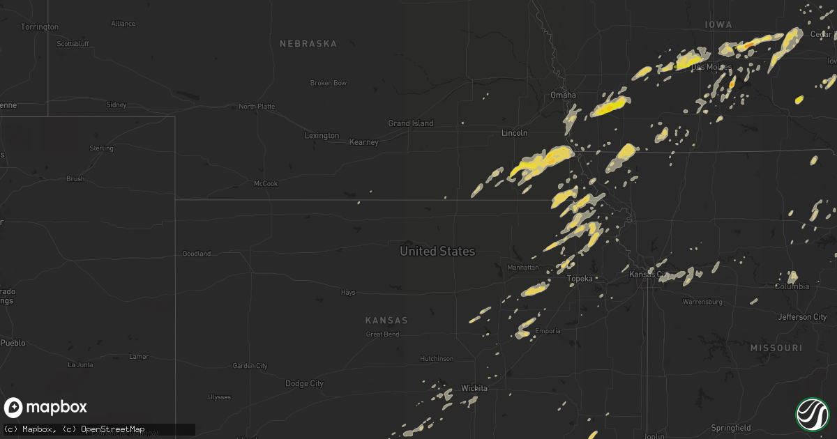
Hail Map on September 19, 2013
Get this storm
September 19 map
$229
one time, instant access
Download today. No call, no setup
Keep the $229
Bought the map and want the full workflow? Apply the entire $229 to a subscription within 7 days. None of it is wasted.
Every map, not just this one
This buys you this map. Subscription and you get every map we run, in the markets you choose from a few cities to whole states to nationwide. Plus real-time alerts the moment a storm fires.
Contact data
Name, contact info, occupancy, even credit band for addresses in the footprint. You go from where it hit to who to call.
Become the source they trust
Unlimited branding weather history reports on demand. You already have the documented answer ready for the property owner, and you are the one who showed up with it.
Property data and RoofTrace estimates
Pull up any address you have got, its value and the exact code rules for that jurisdiction, straight from One Click Code. Then RoofTrace estimates the squares, pitch, and roof value, priced the way you price.
States Impacted by Hail Map on September 19, 2013
Storm reports
Indiana
| Date | Description |
|---|---|
| 09/19/20134:50 PM CDT | Time and exact location from radar. |
| 09/19/20134:50 PM CDT | Crops flattened between 400n and 600n near wadena. Estimated 50 to 60 mph winds. Time estimated by radar. |
| 09/19/20134:05 PM CDT | A local report indicates 1.75 inch wind near KENTLAND |
Missouri
| Date | Description |
|---|---|
| 09/19/20136:45 PM CDT | Large trees down...blown transformer |
| 09/19/20134:13 PM CDT | Large tree branches...small trees and power lines down |
| 09/19/20134:00 PM CDT | 6-10 inch diameter tree limbs down |
| 09/19/20133:50 PM CDT | Estd winds around 60 mph |
| 09/19/20133:47 PM CDT | Large tree limbs down |
| 09/19/20133:40 PM CDT | Tree down |
| 09/19/20133:32 PM CDT | Tree limbs down on powerlines |
| 09/19/20132:57 PM CDT | Estimated 60 mph winds...damage to a few road signs. Powerlines down in rockport. |
| 09/19/20132:57 PM CDT | Tree downed onto a house in tarkio...time estimated via radar |
| 09/18/201310:30 PM CDT | Awning ripped off of gas station. Trees also down. |
| 09/18/20139:45 PM CDT | Tree reported down and blocking roadway in oronogo. |
| 09/18/20139:10 PM CDT | Several small trees were blown down...north of mexico on highway 15. |
Wisconsin
| Date | Description |
|---|---|
| 09/19/20135:59 PM CDT | Large tree limb down - 6 to 8 inch diameter. Time estimated from radar. |
| 09/19/20135:45 PM CDT | Large tree uprooted and many smaller trees snapped. Report from facebook. Time estimated from radar. |
| 09/19/20135:35 PM CDT | Awos measured 53kt wind gust |
| 09/19/20135:30 PM CDT | Delayed report. Scattered reports of trees and power lines downed by thunderstorm wind gusts in an area bounded by evansville and orfordville east to milton...janesvill |
| 09/19/20135:20 PM CDT | Tree branches 4 inch diameter snapped and downed power lines. |
| 09/19/20134:35 PM CDT | Delayed report. Numerous trees and power lines down along a path from northwest of benton to near argyle between 435 pm cdt and 520 pm cdt. |
| 09/19/20134:32 PM CDT | Trees down. |
| 09/19/20134:23 PM CDT | Powerlines down. |
| 09/19/20134:20 PM CDT | Large branches on power lines. |
| 09/19/20134:19 PM CDT | A local report indicates 58 MPH wind near LONE ROCK AIRPORT |
| 09/19/20134:13 PM CDT | Trees down |
| 09/19/20133:47 PM CDT | Trees and power lines down across town. |
| 09/19/201311:55 AM CDT | 1-2 inch diameter tree branches. Also pea-size hail reported. |
| 09/19/201311:51 AM CDT | 8 inch diameter tree branch down. Time estimated from radar. |
| 09/19/201311:51 AM CDT | Pontoon boat and dock it was tied to flipped over on lower clam lake. |
| 09/18/20139:53 PM CDT | Trees blown down and blocking the intersection of hwy 67 and watercress rd. |
| 09/18/20139:45 PM CDT | Delayed report. Trees 2.5 to 3 feet in diameter blown down and blocking the intersection of hwy 28 and hwy 144. |
| 09/18/20139:11 PM CDT | Delayed report. Scattered trees and power lines down in slinger area. Time estimated from radar. |
| 09/18/20139:02 PM CDT | Significant and widespread tree damage starting from druid lake...3 ssw of hartford...to the city of hartford. |
| 09/18/20138:04 PM CDT | A local report indicates 1.00 inch wind near 2 N JANESVILLE |
Iowa
| Date | Description |
|---|---|
| 09/19/20136:51 PM CDT | 8-12 inch diameter tree limb down. |
| 09/19/20136:50 PM CDT | Several large trees down on the west side of town. A cattle shed at the fairgrounds was blown down. Time was estimated. |
| 09/19/20136:35 PM CDT | Delayed report. Awos reported winds gusting to 63 mph starting at 630 pm and continuing through at least 635 pm. |
| 09/19/20136:34 PM CDT | 4-6 inch tree limbs down in town. |
| 09/19/20136:34 PM CDT | 5 inch branch down. Estimated 50 to 60 mph winds. Mn trained spotter. Time estimated. |
| 09/19/20136:30 PM CDT | Estimated 60 mph winds with heavy rain. |
| 09/19/20136:30 PM CDT | Late report. 25 foot tall tree down on west side of town on camp cardinal road. Time estimated. |
| 09/19/20136:30 PM CDT | Measured awos. |
| 09/19/20136:29 PM CDT | Garage roof blown off. House windows broken. Flag pole ripped out of the ground and thrown over the house. |
| 09/19/20136:25 PM CDT | Several reports of limbs down and isolated power poles down in western and southern portions of the county. |
| 09/19/20136:25 PM CDT | Estimated 60 mph winds now with heavy rain on sw side of town. Also possible rotation in clouds. |
| 09/19/20136:16 PM CDT | Relayed by emergency management. |
| 09/19/20136:02 PM CDT | Large tree down and blocking a road in belle plaine |
| 09/19/20136:00 PM CDT | Trees and power lines down in town. 2nd hand report from police scanner. |
| 09/19/20135:55 PM CDT | 6 inch diamter limbs down. |
| 09/19/20135:50 PM CDT | 2 inch diameter limbs down |
| 09/19/20135:35 PM CDT | Awos reports |
| 09/19/20135:32 PM CDT | Several 4-6 inch diameter trees down throughout oskaloosa. |
| 09/19/20135:30 PM CDT | 5 inch branches down around town. Thunderstorm wind gust in excess of 60 mph. |
| 09/19/20135:15 PM CDT | Power line down across 1800 block of highway g76 near attica. Time estimated from radar. |
| 09/19/20134:54 PM CDT | 58 mph winds measured at red rock bridge |
| 09/19/20134:50 PM CDT | Tree limbs down. |
| 09/19/20134:46 PM CDT | Tree across road 80th ave 1/2 mile south of highway 92 from marion county emergeny manager. Time estimated from radar. |
| 09/19/20134:45 PM CDT | Partial roof damage to business located at 5900 douglas avenue |
| 09/19/20134:41 PM CDT | Golf ball sized hail in town. Tree limbs of various sizes down in half a dozen places around the county. From marion county emergency management. Time based on pleasant |
| 09/19/20134:40 PM CDT | 65-70 mph estimated winds. No damage noted. |
| 09/19/20134:39 PM CDT | 60 mph wind gust. |
| 09/19/20134:35 PM CDT | 2-3 inch diameter limb driven through a car windshield. Near douglas and 68th st. |
| 09/19/20134:24 PM CDT | 6 foot section of cedar privacy fence blown over |
| 09/19/20134:15 PM CDT | Semi truck blown over on highway 169. Time estimated from radr. |
| 09/19/20134:11 PM CDT | Altoone rwis data. |
| 09/19/20134:11 PM CDT | Several large tree branches down. |
| 09/19/20134:10 PM CDT | Up to 18 inch diameter limbs/branches down around central ankeny. Wind gusts estimated at 60 mph. |
| 09/19/20134:05 PM CDT | Small to large branches down in ankeny. Business sign damage along 1st street. Construction material on road. |
| 09/19/20134:04 PM CDT | 6-12 inch diameter trees down near ne 5th and ne trilein |
| 09/19/20134:04 PM CDT | 6 inch tree branches down by off duty nws employee house. |
| 09/19/20134:03 PM CDT | No damage at this time. |
| 09/19/20134:03 PM CDT | Six power poles snapped with power lines down on the road. Just west of the intersection of highway 141 and highway 44. |
| 09/19/20134:02 PM CDT | 12 inch diameter pine tree snapped in half. Near intersection of beaver and amick |
| 09/19/20134:00 PM CDT | 6 inch diameter branch snapped |
| 09/19/20134:00 PM CDT | A local report indicates 70 MPH wind near 2 W ANKENY AIRPORT |
| 09/19/20134:00 PM CDT | 6 inch diameter tree snapped |
| 09/19/20134:00 PM CDT | Shingles blown off roofs of several houses |
| 09/19/20134:00 PM CDT | 6-8 inch branch down on road near ankeny blvd and ne 9th street. 9 inches of water still on road slowing traffic. |
| 09/19/20134:00 PM CDT | Shingles blown off of roofs of sevral homes. 12 to 18 inch diameter tree snapped in half. Many 4 to 8 inch diameter branches down |
| 09/19/20134:00 PM CDT | 16 inch diameter tree branch down blocking intersection of clinton ave and 8th street |
| 09/19/20134:00 PM CDT | Exit sign down on east mixmaster |
| 09/19/20133:57 PM CDT | Minor damage to roof of a business at the corner of urbandale ave and merle hay road. |
| 09/19/20133:55 PM CDT | Partial roof damage to business located at 5900 douglas avenue |
| 09/19/20133:55 PM CDT | In windsor heights |
| 09/19/20133:55 PM CDT | 2-3 inch diameter limb driven through a car windshield. Near douglas and 68th st. |
| 09/19/20133:53 PM CDT | Estimated 65 mph winds and quarter size hail. No damage noted at this time. |
| 09/19/20133:50 PM CDT | 6 foot section of cedar privacy fence blown over |
| 09/19/20133:50 PM CDT | Late report. Part of tree snapped off in scotch grove. Time estimated. |
| 09/19/20133:50 PM CDT | A local report indicates 60 MPH wind near URBANDALE |
| 09/19/20133:45 PM CDT | Roof damage reported at south prairie elementary school in grimes. From polk county emergency management. Time estimated from radar. |
| 09/19/20133:45 PM CDT | Nws employee reports powerlines down for about a 1 mile stretch just west of urbandale. Time estimated from radar. |
| 09/19/20133:44 PM CDT | 60 to 70 mph with lots of small to medium size branches. |
| 09/19/20133:43 PM CDT | 8-9 inch diameter pine tree snapped |
| 09/19/20133:41 PM CDT | Tree down and blocking 55th street south of hickman blvd. |
| 09/19/20133:41 PM CDT | Many tree branches down and a few power lines down |
| 09/19/20133:40 PM CDT | Ham radio operator reports 16 inch diameter tree down and garage door blown out |
| 09/19/20133:40 PM CDT | A local report indicates 60 MPH wind near 3 SW CLIVE |
| 09/19/20133:40 PM CDT | Late report. Part of tree snapped off falling on a van outside of anamosa courthouse. Time estimated. |
| 09/19/20133:36 PM CDT | 4 inch diameter tree down with damage to deck. Gutters...soffitt...and shingles blown off shed. Time estimate by radar |
| 09/19/20133:35 PM CDT | 2-9 inch tree limbs down on virtually every street in adel. |
| 09/19/20133:33 PM CDT | A local report indicates 1.00 inch wind near 3 ESE ADEL |
| 09/19/20133:32 PM CDT | Trees reported down onto highway 169 and 15th street in adel. Unknown size at this time. Estimated gusts of 55 to 60 mph. |
| 09/19/20133:30 PM CDT | Power line down along quinlin ave just nw of dallas center. Pole damaged at base and laid over in ditch. Time estimated by radar. |
| 09/19/20133:30 PM CDT | 6-8 diameter limbs blown down. 12 inch diameter tree down north edge of redfield. |
| 09/19/20133:25 PM CDT | Damage to garage |
| 09/19/20133:13 PM CDT | One 12 inch tree branch down in adair. |
| 09/19/20133:10 PM CDT | Ham radio operator reported 12 inch diameter tree down and significant crop damage |
| 09/18/20137:44 PM CDT | Delayed report. Highway sign down at sundown ski resort. |
| 09/18/20137:43 PM CDT | Delayed report. 3 to 4 inch tree limbs down between graf and twin spring. |
| 09/18/20137:10 PM CDT | Large sign blown down...damaging 3 cars. Time estimated. |
| 09/18/20137:00 PM CDT | Nickel to quarter size hail |
Kansas
| Date | Description |
|---|---|
| 09/19/20136:44 PM CDT | Estimated 60 mph in shawnee. Large trees down |
| 09/19/20136:41 PM CDT | Tree down blocking craig dr |
| 09/19/20136:40 PM CDT | Clark drive blocked by trees |
| 09/19/20136:25 PM CDT | Thunderstorm wind gust was estimated up to 60 mph at 49th and rainbow. |
| 09/19/20136:12 PM CDT | Delayed report |
| 09/19/20135:32 PM CDT | Sporadic tree damage reported in lawrence. Generally small limbs down. One tree down blocking the road near 17th street and alabama street. |
| 09/19/20135:20 PM CDT | Large branches down in auburn |
Minnesota
| Date | Description |
|---|---|
| 09/19/201312:21 PM CDT | Two trees blown down along the kettle river near i-35. Time estimated from radar. |
| 09/19/201311:20 AM CDT | Several 6-8 inch tree branches blown down |
| 09/19/201311:18 AM CDT | Numerous aspen branches blown down. Twelve inch diameter poplar tree snapped 20 feet above ground level. |
| 09/19/201310:56 AM CDT | A local report indicates 2.00 inch wind near 2 S CAMBRIDGE |
| 09/19/201310:56 AM CDT | A local report indicates 2.00 inch wind near 1 S CAMBRIDGE |
| 09/19/201310:40 AM CDT | Trees scattered across south half of isanti co |
| 09/19/201310:30 AM CDT | Metro transit bus operator reported large tree on car at intersection of 37th ave ne and 2 1/2 st. Ne in northeast minneapolis. Time estimated. |
| 09/19/201310:10 AM CDT | A local report indicates 1.25 inch wind near 2 N ELK RIVER |
| 09/19/201310:02 AM CDT | A local report indicates 1.50 inch wind near 1 W BIG LAKE |
| 09/19/201310:00 AM CDT | Tree limbs blocking sb wright cr8 |
| 09/19/201310:00 AM CDT | I-94 and wright cty hwy 118 |
| 09/19/20139:51 AM CDT | A local report indicates 1.00 inch wind near 4 SSE LAKE MARIA STATE |
| 09/19/20139:45 AM CDT | Several large tree limbs down in silver lake...with some corn fields flattened by strong winds outside of town. |
| 09/19/20139:44 AM CDT | Tree limbs blocking sb wright cr8 |
| 09/19/20139:40 AM CDT | *** 1 inj *** large tree fell on a vehicle traveling on jefferson st. One person with minor injuries. |
| 09/19/20139:40 AM CDT | A local report indicates 1.75 inch wind near MAPLE LAKE |
| 09/19/20138:54 AM CDT | Measured at kmnrenv12 |
| 09/19/20138:33 AM CDT | Measured at granite falls airport |
| 09/19/20138:10 AM CDT | Numerous branches down and corn totally flattened. |
| 09/19/20138:02 AM CDT | Branches down |
| 09/19/20138:00 AM CDT | A local report indicates 60 MPH wind near MARSHALL |
| 09/19/20137:57 AM CDT | Three empty rail cars blown down tracks at adm plant. Estimated winds around 70 mph. |
| 09/19/20137:55 AM CDT | Pea size hail and heavy rain |
| 09/19/20137:55 AM CDT | Three empty rail cars blown over at adm plant. Estimated winds around 70 mph. |
Illinois
| Date | Description |
|---|---|
| 09/18/20137:25 PM CDT | Trees and power lines down throughout town. |
Texas
| Date | Description |
|---|---|
| 09/19/20135:45 PM CDT | Minor wind damage to outbuildings on county road 6 at 1.5 miles south of hwy 15. |
| 09/19/20133:30 PM CDT | Minor wind damage to outbuildings on county road 6 at 1.5 miles south of hwy 15. Corrected event time. There was no damage at 545 pm |
Oklahoma
| Date | Description |
|---|---|
| 09/19/20132:38 PM CDT | Tree damage and semi-truck rolled near woodson park near i-44 between sw 44th and 29th st. |
| 09/19/20132:00 PM CDT | Large tree snapped in utica square. Relayed by broadcast media. |
| 09/19/20131:55 PM CDT | Small 4 to 6 inch diameter tree broken near tulsa hills. |
| 09/19/20131:55 PM CDT | Small 4 to 6 inch diameter tree broken near tulsa hills. |
Nebraska
| Date | Description |
|---|---|
| 09/19/20133:05 PM CDT | Estimated winds of 75mph. Outhouse tipped over and tin ripped from buildings. Delayed report. |
| 09/19/20133:00 PM CDT | Trees and powerlines downed estimated 60-70mph. Report relayed by local media. |
| 09/19/20132:45 PM CDT | Semi-trailer blown over near hwy 67/75 and other wind strewn debris. Delayed report. |
| 09/19/20131:59 PM CDT | A local report indicates 1.25 inch wind near 8 NE BEATRICE |
Cities Impacted by Hail Map on September 19, 2013
- Osceola, IA
- Sterling, NE
- Tecumseh, NE
- Adams, NE
- Hutchinson, MN
- Milo, IA
- Ackworth, IA
- Linden, IA
- Redfield, IA
- Dexter, IA
- Stuart, IA
- Menlo, IA
- Elliott, IA
- Griswold, IA
- Emerson, IA
- Red Oak, IA
- Villisca, IA
- Durham, KS
- Gypsum, KS
- Paxico, KS
- Mechanicsville, IA
- Anamosa, IA
- Morley, IA
- New Virginia, IA
- Hazel Green, WI
- Platteville, WI
- Cuba City, WI
- Wellman, IA
- Washington, IA
- Elk River, MN
- Saint Francis, MN
- Zimmerman, MN
- Vega, TX
- Sabetha, KS
- Oneida, KS
- Seneca, KS
- Fairfax, OK
- Ralston, OK
- Cambridge, MN
- Lismore, MN
- Mount Vernon, IA
- Grant, IA
- Cumberland, IA
- Henderson, IA
- Hastings, IA
- Runnells, IA
- Mitchellville, IA
- Pleasant Hill, IA
- Altoona, IA
- Hector, MN
- Franklin, MN
- Fairfax, MN
- Urbandale, IA
- Waukee, IA
- Grimes, IA
- Clive, IA
- Adel, IA
- Dallas Center, IA
- Kerkhoven, MN
- Harris, MN
- Stanchfield, MN
- Grandy, MN
- Rush City, MN
- Norwich, KS
- Milton, KS
- Viola, KS
- Higgins, TX
- Philadelphia, MO
- Monroe City, MO
- Plymouth, IL
- Colchester, IL
- Wauzeka, WI
- Boscobel, WI
- Truro, IA
- Alva, OK
- Adair, IA
- Exira, IA
- Casey, IA
- Anita, IA
- Cummings, KS
- Marion, KS
- Hillsboro, KS
- Baylis, IL
- Council Grove, KS
- Edgerton, WI
- Janesville, WI
- York, NE
- Murdock, KS
- Cheney, KS
- Prairie Du Chien, WI
- Edna, KS
- Coffeyville, KS
- Topeka, KS
- Auburn, KS
- Diagonal, IA
- Lenox, IA
- Rossville, KS
- Coin, IA
- Perryton, TX
- Mineral Point, WI
- Dodgeville, WI
- Crab Orchard, NE
- San Jon, NM
- Grinnell, IA
- Dora, MO
- Olin, IA
- Cascade, IA
- Monticello, IA
- Center Junction, IA
- Wyoming, IA
- Mound City, MO
- Muscotah, KS
- Valley Falls, KS
- Everest, KS
- Holton, KS
- Lancaster, KS
- Effingham, KS
- Oak Grove, MO
- Wellington, MO
- Lees Summit, MO
- Blue Springs, MO
- Sibley, MO
- Kansas City, MO
- Grain Valley, MO
- Napoleon, MO
- Buckner, MO
- Bates City, MO
- Independence, MO
- Grantsburg, WI
- Kalona, IA
- Riverside, IA
- East Dubuque, IL
- Galena, IL
- Stockton, IL
- Grenville, NM
- Dyersville, IA
- Worthington, IA
- Earlville, IA
- Balko, OK
- Follett, TX
- Laverne, OK
- Booker, TX
- Rocheport, MO
- Hedrick, IA
- Ollie, IA
- Martinsburg, IA
- Fairbury, NE
- Brixey, MO
- Zanoni, MO
- Mount Ayr, IA
- Benton, IA
- Amarillo, TX
- Otterville, MO
- Bunceton, MO
- Dawson, MN
- Freedom, OK
- Anthony, KS
- Attica, KS
- Brewster, MN
- Harper, KS
- Burr, NE
- Filley, NE
- Cook, NE
- Beatrice, NE
- Pickrell, NE
- Lorton, NE
- Julian, NE
- Dunbar, NE
- Nebraska City, NE
- Brock, NE
- Talmage, NE
- Peru, NE
- Syracuse, NE
- Virginia, NE
- Netawaka, KS
- Wetmore, KS
- Powhattan, KS
- Pleasantville, IA
- Lamberton, MN
- Westbrook, MN
- Brookston, IN
- Wolcott, IN
- Fowler, IN
- Remington, IN
- Big Lake, MN
- Becker, MN
- Kouts, IN
- La Crosse, IN
- Burlington Junction, MO
- Grant City, MO
- Allen, KS
- Humboldt, NE
- Stella, NE
- Anoka, MN
- Lake Benton, MN
- Tyler, MN
- Ruthton, MN
- Isanti, MN
- Watseka, IL
- Carlisle, IA
- Morocco, IN
- Donovan, IL
- Epworth, IA
- Farley, IA
- Belle Plaine, IA
- Cottonwood Falls, KS
- Cherryvale, KS
- Newton, IA
- Baxter, IA
- Melbourne, IA
- Laurel, IA
- Warrens, WI
- Black River Falls, WI
- Falls City, NE
- Morrill, KS
- Hiawatha, KS
- Cedar, MN
- Bethel, MN
- Goodland, IN
- Brook, IN
- Kentland, IN
- Mayetta, KS
- Hoyt, KS
- Monticello, MN
- Otley, IA
- Mukwonago, WI
- Waterford, WI
- Big Bend, WI
- Hartford, IA
- Sandstone, MN
- Cokato, MN
- Annandale, MN
- Maple Lake, MN
- Buffalo, MN
- Howard Lake, MN
- Gainesville, MO
- Bakersfield, MO
- Clarkridge, AR
- Gamaliel, AR
- Waterloo, WI
- Juneau, WI
- Reeseville, WI
- Beaver Dam, WI
- Carson, IA
- Malvern, IA
- Cortland, NE
- Lewiston, NE
- Johnson, NE
- Saint Croix Falls, WI
- Thomson, IL
- Monroe, IA
- Prairie City, IA
- Whiting, KS
- Indianola, IA
- Mount Carroll, IL
- Towanda, KS
- Sperry, OK
- Skiatook, OK
- Collinsville, OK
- Bruno, MN
- Scales Mound, IL
- Dubuque, IA
- Dassel, MN
- Iron Ridge, WI
- Flandreau, SD
- Lawrence, KS
- Baldwin City, KS
- Arena, WI
- Barneveld, WI
- Sapulpa, OK
- Elkton, SD
- White, SD
- Maple Hill, KS
- Delia, KS
- Silver Lake, KS
- North Judson, IN
- Odessa, MO
- Mayview, MO
- Lexington, MO
- Gilman, IA
- Maxwell, IA
- Bondurant, IA
- Mingo, IA
- Hustisford, WI
- Lebanon, WI
- Mayville, WI
- Watertown, WI
- Neosho, WI
- Rubicon, WI
- Clyman, WI
- Hardesty, OK
- Shullsburg, WI
- Wilsey, KS
- Salem, AR
- Bexar, AR
- Viola, AR
- Raymond, MN
- Murdock, MN
- Cazenovia, WI
- Richland Center, WI
- Blue River, WI
- Muscoda, WI
- University Park, IL
- Crete, IL
- Craig, MO
- Rulo, NE
- White Cloud, KS
- Fairview, KS
- Horton, KS
- Truman, MN
- Danbury, WI
- Frederic, WI
- North Branch, MN
- Braham, MN
- Princeton, MN
- Webster, WI
- Pine City, MN
- Luck, WI
- Spooner, WI
- Siren, WI
- Cushing, WI
- Trego, WI
- Brandon, IA
- Rowley, IA
- Independence, IA
- Fair Oaks, IN
- Verdon, NE
- Anabel, MO
- Clarence, MO
- Macon, MO
- Thayer, IA
- Murray, IA
- Luverne, MN
- Beaver Creek, MN
- Edgerton, MN
- Hardwick, MN
- Chariton, IA
- Derby, IA
- Lucas, IA
- Luther, OK
- Bagley, WI
- Mount Hope, WI
- Garnavillo, IA
- Glen Haven, WI
- Patch Grove, WI
- Guttenberg, IA
- Bloomington, WI
- Rueter, MO
- Clearwater, KS
- Grasston, MN
- Valparaiso, IN
- Milwaukee, WI
- Heron Lake, MN
- Savanna, IL
- Bellevue, IA
- Miles, IA
- Hanover, IL
- Rewey, WI
- Arbela, MO
- Luray, MO
- Gaylord, MN
- Swan, IA
- Knoxville, IA
- Lacona, IA
- Blockton, IA
- Shannon City, IA
- Clearfield, IA
- Macomb, IL
- Springville, IA
- Ely, IA
- Marion, IA
- Cedar Rapids, IA
- Clarinda, IA
- Bedford, IA
- Clearmont, MO
- Braddyville, IA
- Hopkins, MO
- New Market, IA
- Elmo, MO
- Chelsea, IA
- Brooklyn, IA
- Des Moines, NM
- Altamont, KS
- Mound Valley, KS
- Arlington, IA
- Sanborn, MN
- Fairfax, IA
- Norway, IA
- Hamburg, IA
- Booneville, IA
- Tampa, KS
- Oconomowoc, WI
- Ixonia, WI
- Elmdale, KS
- Emporia, KS
- Strong City, KS
- Spearman, TX
- Luzerne, IA
- Palmyra, MO
- Darlington, WI
- Tingley, IA
- Buffalo Lake, MN
- Lecompton, KS
- Pacific Junction, IA
- Alta Vista, KS
- Alma, KS
- Tama, IA
- Montour, IA
- Sheldon, IL
- Chalmers, IN
- Iroquois, IL
- Earl Park, IN
- Tucumcari, NM
- Atchison, KS
- Colfax, IA
- Marshalltown, IA
- Collins, IA
- Haverhill, IA
- Elkhart, IA
- Toledo, IA
- Rhodes, IA
- Bethel, MO
- Shelbina, MO
- Ewing, MO
- Shelbyville, MO
- La Belle, MO
- Bristow, OK
- Circleville, KS
- Stacy, MN
- Maywood, MO
- Taylor, MO
- La Grange, MO
- Hatfield, MO
- Plattsmouth, NE
- Vandalia, MO
- Center, MO
- Milroy, MN
- Drury, MO
- Mountain Home, AR
- Polk City, IA
- Earlham, IA
- Madrid, IA
- Johnston, IA
- Granger, IA
- Woodward, IA
- Minburn, IA
- Des Moines, IA
- Ankeny, IA
- Fredonia, KS
- West Chester, IA
- Keota, IA
- Tracy, MN
- Hazelton, KS
- Waldron, KS
- Hollandale, WI
- Byron, NE
- Bern, KS
- Du Bois, NE
- Dawson, NE
- Warsaw, IL
- Fennimore, WI
- Woodman, WI
- Benton, KS
- Wiota, IA
- Waverly, MO
- Malta Bend, MO
- Alma, MO
- Logan, NM
- Mosquero, NM
- Havensville, KS
- Goff, KS
- Onaga, KS
- Soldier, KS
- Denison, KS
- Robinson, KS
- White Sands Missile Range, NM
- La Valle, WI
- Milton, WI
- Atlantic, IA
- Lewis, IA
- Clayton, NM
- Kellyville, OK
- Kellerton, IA
- Saint James, MN
- Holy Cross, IA
- Franklin, NE
- Hope, KS
- Wichita, KS
- Haysville, KS
- Peck, KS
- Derby, KS
- Deming, NM
- Kingman, KS
- Pretty Prairie, KS
- Hallsville, MO
- Columbia, MO
- Sturgeon, MO
- Plymouth, NE
- De Witt, NE
- Corning, KS
- West Plains, MO
- Kiowa, KS
- Tarkio, MO
- Skidmore, MO
- Fairfax, MO
- Endeavor, WI
- Oxford, WI
- Briggsville, WI
- Pipestone, MN
- Salem, NE
- Conception Junction, MO
- Barnard, MO
- Maryville, MO
- Miami, MO
- Ursa, IL
- Mountain Lake, MN
- Comfrey, MN
- Jeffers, MN
- McGregor, IA
- Seminole, OK
- Ridgeway, WI
- Sully, IA
- Marshall, WI
- Mcfarland, WI
- Stoughton, WI
- Deerfield, WI
- Cottage Grove, WI
- Alton, MO
- Riverton, IA
- Medicine Lodge, KS
- Sharon, KS
- Vinton, IA
- Longton, KS
- Elk City, KS
- Russell, MN
- Marshall, MN
- Balaton, MN
- Lynd, MN
- Owasso, OK
- Tulsa, OK
- Gruver, TX
- Stratford, TX
- Auburn, NE
- Wood Lake, MN
- Echo, MN
- Belview, MN
- Payson, IL
- Cottonwood, MN
- Sacred Heart, MN
- Granite Falls, MN
- Elberon, IA
- Montezuma, IA
- Hartwick, IA
- Malcom, IA
- Van Horne, IA
- Keystone, IA
- Vining, IA
- Clutier, IA
- Searsboro, IA
- Saint George, KS
- Maquoketa, IA
- Slater, MO
- Olivia, MN
- Magnolia, MN
- Princeton, WI
- Madison, MO
- Lentner, MO
- Bingham Lake, MN
- Depew, OK
- Moberly, MO
- Laddonia, MO
- Perry, MO
- Durango, IA
- Dwight, KS
- Eskridge, KS
- Richmond, MO
- Columbia, IA
- Lovilia, IA
- Wamego, KS
- Reynolds, NE
- Canton, IL
- Fairwater, WI
- Brandon, WI
- Markesan, WI
- Poynette, WI
- Okabena, MN
- Lakefield, MN
- Delhi, IA
- Troy, KS
- Winthrop, IA
- Willow Springs, MO
- Hinckley, MN
- Wisconsin Dells, WI
- Bird Island, MN
- Montfort, WI
- Highland, WI
- Lyndon Station, WI
- Reedsburg, WI
- Decatur, IA
- Davis City, IA
- Elizabeth, IL
- Bernard, IA
- Livingston, WI
- Burlington, WI
- Panora, IA
- Guthrie Center, IA
- Graham, MO
- Percival, IA
- Glenwood, IA
- Excelsior Springs, MO
- Lafayette, MN
- Gibbon, MN
- Wymore, NE
- Liberty, NE
- Colesburg, IA
- Cassville, WI
- Solon, IA
- Masterson, TX
- West Des Moines, IA
- White City, KS
- Danville, KS
- Argonia, KS
- Douglas, NE
- Rock Port, MO
- Blue Springs, NE
- Center Point, IA
- Hubbell, NE
- Wellston, OK
- Carney, OK
- Saint Michael, MN
- Ellston, IA
- Canton, KS
- La Porte City, IA
- Kenneth, MN
- Rock Springs, WI
- Norborne, MO
- Hardin, MO
- Harrisburg, MO
- Farmersburg, IA
- Saint Olaf, IA
- Kellogg, IA
- La Motte, IA
- Holliday, MO
- Winamac, IN
- May, OK
- Cambridge, WI
- Higginsville, MO
- Minong, WI
- Walnut Grove, MN
- Zwingle, IA
- Parsons, KS
- Weldon, IA
- Bouton, IA
- Perry, IA
- Greenfield, IA
- Merrimac, WI
- Baraboo, WI
- Steen, MN
- Bartlesville, OK
- Reasnor, IA
- David City, NE
- Walker, IA
- Agra, KS
- Denver, MO
- Boonville, MO
- Wideman, AR
- Holland, MN
- Garvin, MN
- Ghent, MN
- Astoria, SD
- Aurora, SD
- Maitland, MO
- Dawson, IA
- Yale, IA
- Garden Plain, KS
- Burns, KS
- Diller, NE
- Jansen, NE
- Atkins, IA
- Palo, IA
- New Ulm, MN
- West Bend, WI
- Preston, IA
- Spragueville, IA
- Potosi, WI
- Beloit, WI
- Redwood Falls, MN
- Volga, IA
- Martelle, IA
- Vesta, MN
- Pearl City, IL
- Lanark, IL
- Westboro, MO
- Northboro, IA
- Industry, IL
- Waupun, WI
- Albertville, MN
- Brook Park, MN
- Silver Lake, MN
- Stewart, MN
- Clayton, IL
- Plainville, IL
- Avalon, WI
- Darien, WI
- Tipton, IA
- Mount Auburn, IA
- Augusta, IL
- Bowen, IL
- Jasper, MN
- Lisbon, IA
- Sleepy Eye, MN
- Herington, KS
- Shellsburg, IA
- Basehor, KS
- Tonganoxie, KS
- Leavenworth, KS
- Oakland, IA
- Burdick, KS
- Lena, IL
- Burchard, NE
- Fox Lake, WI
- Winthrop, MN
- Pella, IA
- Liberty, MO
- Grand River, IA
- Montello, WI
- Warren, IL
- Argyle, WI
- South Wayne, WI
- Gratiot, WI
- Madison, WI
- San Pierre, IN
- Mannford, OK
- Melcher Dallas, IA
- Raton, NM
- Benton, WI
- Nemaha, NE
- Loganville, WI
- Murray, NE
- Union, NE
- Thurman, IA
- Saint Marys, KS
- Hardtner, KS
- Hartford, WI
- Rushville, MO