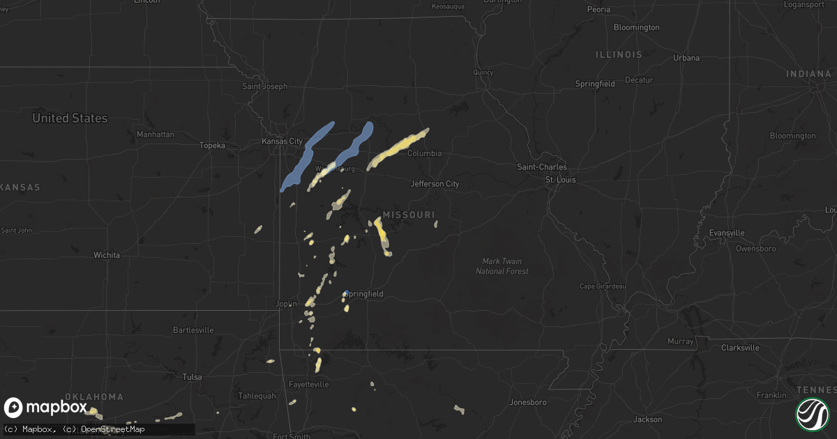
Hail Map in Missouri on September 18, 2025
Get this storm
September 18 map
$229
one time, instant access
Download today. No call, no setup
Keep the $229
Bought the map and want the full workflow? Apply the entire $229 to a subscription within 7 days. None of it is wasted.
Every map, not just this one
This buys you this map. Subscription and you get every map we run, in the markets you choose from a few cities to whole states to nationwide. Plus real-time alerts the moment a storm fires.
Contact data
Name, contact info, occupancy, even credit band for addresses in the footprint. You go from where it hit to who to call.
Become the source they trust
Unlimited branding weather history reports on demand. You already have the documented answer ready for the property owner, and you are the one who showed up with it.
Property data and RoofTrace estimates
Pull up any address you have got, its value and the exact code rules for that jurisdiction, straight from One Click Code. Then RoofTrace estimates the squares, pitch, and roof value, priced the way you price.
Storm reports in Missouri
Missouri
| Date | Description |
|---|---|
| 09/18/20256:45 PM CDT | Power pole knocked down. |
| 09/18/20256:21 PM CDT | Downed wires and tree limbs near county road 111. Dispatch also reported strong winds south and east of miami. Time estimated from radar. |
| 09/18/20256:14 PM CDT | Social media reports of a downed tree at a local buisness in seadlia. Another posted video of very strong winds at a residence with small limbs downed. Time based on so |
| 09/18/20256:08 PM CDT | Several reports of downed limbs and wires south of smithton. Time estimated from radar. |
| 09/18/20255:32 PM CDT | Several reports of trees and tree limbs down in the macks creek area. Electric company also reporting several outages in the area. |
| 09/18/20255:32 PM CDT | Several trees were downed along highway w west of macks creek. One tree fell and damaged a roof of a house. A barn was also destroyed. |
| 09/18/20255:26 PM CDT | Multiple reports of downed wires east of route y. Time estimated from radar. |
| 09/18/20255:24 PM CDT | Several reports of downed limbs and wires near leesville. Time estimated from radar. |
| 09/18/20255:14 PM CDT | Tree down blocking the road. |
| 09/18/20255:12 PM CDT | Limbs down. Power out. |
| 09/18/20255:07 PM CDT | A local report indicates 1.00 inch wind near Weaubleau |
| 09/18/20255:05 PM CDT | Delayed report. Mesonet station gw3465 osceola. |
| 09/18/20254:59 PM CDT | Multiple reports of downed wires and power outages in the lexington area. Time estimated from radar. |
| 09/18/20254:59 PM CDT | Several reports of tree limb and powerline damage near and south of fayetteville. Time estimated from radar. |
| 09/18/20254:56 PM CDT | Utility company reports multiple trees and wires down north of warrensburg. Time estimated from radar. |
| 09/18/20254:55 PM CDT | Thunderstorm winds downed a tree just north of windyville on state highway k. |
| 09/18/20254:54 PM CDT | Thunderstorm winds down a tree on old prospect road. |
| 09/18/20254:50 PM CDT | Social media report of a downed tree damaging three vehicles at the university of central missouri. Time estimated from radar. |
| 09/18/20254:50 PM CDT | Hail to the size of quarters fell three miles north of sarcoxie. |
| 09/18/20254:49 PM CDT | Private weather sensor. |
| 09/18/20254:48 PM CDT | Social media report of a barn severely damaged. Time estimated from radar. |
| 09/18/20254:48 PM CDT | Utility company reports multiple trees and wires down just south of centerview. Time estimated from radar. |
| 09/18/20254:45 PM CDT | Personal weather station. |
| 09/18/20254:45 PM CDT | Powerline down. |
| 09/18/20254:44 PM CDT | Social media report and video. Mostly small hail... But some hail up to qu |
| 09/18/20254:44 PM CDT | Social media report of downed tree limbs on u.s. Highway 24 near napoleon. Utility company reported tree and wire damage in this area as well. Time estimated from radar |
| 09/18/20254:44 PM CDT | Large tree and powerline down. |
| 09/18/20254:43 PM CDT | A local report indicates 66 MPH wind near 4 NE Centerview |
| 09/18/20254:42 PM CDT | Social media report of minor damage to a residence just west of centerview. Time estimated from radar. |
| 09/18/20254:40 PM CDT | Tree downed. Time estimated via radar. |
| 09/18/20254:38 PM CDT | Tree down on house. Report via social media. |
| 09/18/20254:38 PM CDT | Multiple reports of tree damage east of holden and southwest of centerview. Multiple powerlines down and power outages reported as well. Time estimated from radar. |
| 09/18/20254:36 PM CDT | Social media report of up to quarter size hail damaging crops and a garden at a residence. Time estimated from radar. |
| 09/18/20254:34 PM CDT | Social media report of a downed tree at a residence. Time estimated from radar. |
| 09/18/20254:32 PM CDT | Social media report and photos of downed trees at a residence in oak grove. Time estimated from radar. |
| 09/18/20254:32 PM CDT | Downed wires reported near owings street. Time estimated from radar. |
| 09/18/20254:32 PM CDT | Downed wires and power outages near meadow lane. Time estimated from radar. |
| 09/18/20254:30 PM CDT | Social media report of a corn field flattened by strong winds south of holden. Additional report of downed wires in the area. Time estimated from radar. |
| 09/18/20254:28 PM CDT | Branches down... Six foot fence down. |
| 09/18/20254:15 PM CDT | Tree limbs down in el dorado springs. |
| 09/18/20254:11 PM CDT | Power lines downed. |
| 09/18/20254:06 PM CDT | Tree down on south side of pleasant hill. Report via social media. |
| 09/18/20253:58 PM CDT | Social media report of a downed tree on 203rd street between routes j and 291. Time estimated from radar. |
| 09/18/20253:53 PM CDT | Downed tree and wires near route 291. Time based on dispatch report and confirmed from radar. |
| 09/18/20253:27 PM CDT | Trees and power poles down in lamar. |
| 09/18/20253:20 PM CDT | A tree was down due to thunderstorm winds and was blocking the road on state highway mm near lawrenceburg. |
| 09/17/20257:36 PM CDT | Multiple reports of downed powerlines near route a. Time estimated from radar. |
| 09/17/20257:29 PM CDT | Several reports of downed wires and power outages southeast of fayette. Time estimated from radar. |
| 09/17/20257:13 PM CDT | Power pole downed by storm. |
| 09/17/20257:09 PM CDT | Multiple tree limbs and wires down just north of new franklin. Time estimated from radar. |
| 09/17/20257:07 PM CDT | Several reports of downed power lines northwest of new franklin. Time estimated from radar. |
| 09/17/20257:04 PM CDT | Social media photos of multiple trees and limbs down between franklin and new franklin. Time estimated from radar. |
| 09/17/20257:00 PM CDT | Power pole downed by storm. |
All States Impacted by Hail Map on September 18, 2025
Cities Impacted by Hail Map on September 18, 2025
- Quartzsite, AZ
- Mena, AR
- Bronson, KS
- Mapleton, KS
- Detroit, TX
- Blue Mound, KS
- Waldron, AR
- Poteau, OK
- Booneville, AR
- Perryville, AR
- Blossom, TX
- Lowell, AR
- Springdale, AR
- Ash Grove, MO
- Bois D Arc, MO
- Salome, AZ
- Magazine, AR
- Clarksville, TX
- Cibola, AZ
- Wellton, AZ
- Rogers, AR
- Blythe, CA
- Bouse, AZ
- De Kalb, TX
- Lamar, MO
- Wister, OK
- Huntington, AR
- Republic, MO
- Butler, MO
- Fort Smith, AR
- Greenwood, AR
- Garfield, AR
- Seligman, MO
- Shady Point, OK
- Jasper, MO
- Drexel, MO
- Freeman, MO
- Harrisonville, MO
- Archie, MO
- Peculiar, MO
- Cleveland, MO
- Pleasant Hill, MO
- Haworth, OK
- Walker, MO
- Billings, MO
- Pierce City, MO
- Granby, MO
- Charleston, AR
- Marionville, MO
- Everton, MO
- Creighton, MO
- Greenwood, MO
- Lone Jack, MO
- Grain Valley, MO
- Lees Summit, MO
- Dadeville, MO
- Rocky Comfort, MO
- Arcola, MO
- Stockton, MO
- Jay, OK
- Fairview, MO
- Stark City, MO
- El Dorado Springs, MO
- Harwood, MO
- Garden City, MO
- Colcord, OK
- Pea Ridge, AR
- Bentonville, AR
- Jerico Springs, MO
- Sheldon, MO
- Kingsville, MO
- Oak Grove, MO
- Bates City, MO
- Holden, MO
- Ozone, AR
- Winnett, MT
- Eagletown, OK
- Wentworth, MO
- Lavaca, AR
- Canehill, AR
- Prairie Grove, AR
- Sarcoxie, MO
- Sibley, MO
- Napoleon, MO
- Buckner, MO
- Wellington, MO
- Orrick, MO
- Odessa, MO
- Appleton City, MO
- Osceola, MO
- De Queen, AR
- Deer, AR
- Reeds, MO
- Carthage, MO
- Long Lane, MO
- Centerview, MO
- Washburn, MO
- Windyville, MO
- Powell, MO
- Lexington, MO
- Humansville, MO
- Warrensburg, MO
- Henrietta, MO
- Camden, MO
- Richmond, MO
- Hardin, MO
- Monett, MO
- Buffalo, MO
- Deepwater, MO
- Lowry City, MO
- Evansville, AR
- Jefferson, TX
- Roll, AZ
- Weaubleau, MO
- Collins, MO
- Lockesburg, AR
- Norborne, MO
- Knob Noster, MO
- Concordia, MO
- Sweet Springs, MO
- Neosho, MO
- Tunas, MO
- La Russell, MO
- Malvern, AR
- Donaldson, AR
- Gillham, AR
- Clinton, MO
- Stella, MO
- Wheatland, MO
- Cross Timbers, MO
- Lockwood, MO
- Briscoe, TX
- Friendship, AR
- Macks Creek, MO
- Calhoun, MO
- Miller, MO
- South Greenfield, MO
- Edwards, CA
- Houstonia, MO
- Blackburn, MO
- Malta Bend, MO
- Edwards, MO
- Greenfield, MO
- Canadian, TX
- Stotts City, MO
- Vendor, AR
- Jasper, AR
- Marble Falls, AR
- Windsor, MO
- Arkadelphia, AR
- Golden City, MO
- Marshall, MO
- Reydon, OK
- Sweetwater, OK
- Plainfield, WI
- Climax Springs, MO
- Miami, MO
- Slater, MO
- Bancroft, WI
- Worden, MT
- Palm Desert, CA
- Sedalia, MO
- Maiden Rock, WI
- Plum City, WI
- Indian Wells, CA
- Rancho Mirage, CA
- Pilot Grove, MO
- Hughesville, MO
- Nelson, MO
- Phillipsburg, MO
- Lebanon, MO
- Custer, MT
- Blackwater, MO
- Boonville, MO
- Wheeler, TX
- Pompeys Pillar, MT
- Almond, WI
- Franklin, MO
- New Franklin, MO
- Fayette, MO
- Rocheport, MO
- Harrisburg, MO
- Clark, MO
- Sturgeon, MO
- Heber, CA
- Calexico, CA
- El Centro, CA
- Dixon, MO
- Holtville, CA
- Imperial, CA
- Brawley, CA
- Brinktown, MO
- Niland, CA
- Winterhaven, CA
- Quitaque, TX
- Arlington, AZ
- Twentynine Palms, CA
- Hayfork, CA
- Joplin, MO
- Noble, OK
- Norman, OK
- Canute, OK
- Dill City, OK
- Cordell, OK
- Carnegie, OK
- Wewoka, OK
- Scottsdale, AZ
- Phoenix, AZ
- Fort Cobb, OK
- Gracemont, OK
- Apache, OK
- Anadarko, OK
- Edmond, OK
- Guthrie, OK
- Piedmont, OK
- Oklahoma City, OK
- Spencer, OK
- Choctaw, OK
- Batesville, AR
- Harrah, OK
- Meeker, OK
- Wellston, OK
- Locust Grove, AR
- Newalla, OK
- Chandler, OK
- Surprise, AZ
- Paden, OK
- Sun City, AZ
- El Mirage, AZ
- Sun City West, AZ
- Castle, OK
- Peoria, AZ
- Okemah, OK
- Bristow, OK
- Marcella, AR
- Okmulgee, OK
- Allen, OK
- Beggs, OK
- Calvin, OK
- Atwood, OK
- Haskell, OK
- Boynton, OK


