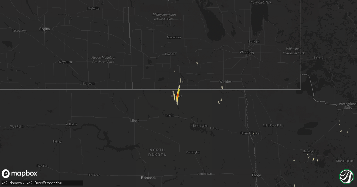
Hail Map on September 18, 2024
Get this storm
September 18 map
$229
one time, instant access
Download today. No call, no setup
Keep the $229
Bought the map and want the full workflow? Apply the entire $229 to a subscription within 7 days. None of it is wasted.
Every map, not just this one
This buys you this map. Subscription and you get every map we run, in the markets you choose from a few cities to whole states to nationwide. Plus real-time alerts the moment a storm fires.
Contact data
Name, contact info, occupancy, even credit band for addresses in the footprint. You go from where it hit to who to call.
Become the source they trust
Unlimited branding weather history reports on demand. You already have the documented answer ready for the property owner, and you are the one who showed up with it.
Property data and RoofTrace estimates
Pull up any address you have got, its value and the exact code rules for that jurisdiction, straight from One Click Code. Then RoofTrace estimates the squares, pitch, and roof value, priced the way you price.
States Impacted by Hail Map on September 18, 2024
Storm reports
Florida
| Date | Description |
|---|---|
| 09/18/20243:25 PM CDT | A small tree was reported down near the intersection of riberia st and south st near downtown st augustine. Time estimated by radar. |
| 09/18/20243:15 PM CDT | Tree reported down on a power line causing sparks near 4435 coastal hwy in vilano beach. Time estimated by radar. |
North Dakota
| Date | Description |
|---|---|
| 09/17/20247:35 PM CDT | Most hail was dime size but a few hailstones were up to the size of quarters. |
| 09/17/20247:31 PM CDT | Delayed report. Broadcast media passed along pictures of hailstones estimated to be as large as golf balls. Time estimated via radar. |
Cities Impacted by Hail Map on September 18, 2024
- Osnabrock, ND
- Langdon, ND
- Edinburg, ND
- Walhalla, ND
- East Grand Forks, MN
- Opa Locka, FL
- Miami, FL
- Miami Gardens, FL
- Hollywood, FL
- Bunnell, FL
- Ashland, KS
- Delray Beach, FL
- West Palm Beach, FL
- Boca Raton, FL
- Protection, KS
- Coldwater, KS
- Follett, TX
- Booker, TX
- Edgewater, FL
- Oak Hill, FL
- New Smyrna Beach, FL
- Devils Lake, ND
- Rolette, ND
- Belcourt, ND
- Mylo, ND
- Shattuck, OK
- Rolla, ND
- Saint John, ND
- Merritt Island, FL
- Titusville, FL
- Cape Canaveral, FL
- Patrick Afb, FL
- Cocoa Beach, FL
- New York Mills, MN
- Bagley, MN
- Big Falls, MN
- Laporte, MN
- Cass Lake, MN
- Bemidji, MN
- Oakland, NE
- Lyons, NE
- Craig, NE
- Decatur, NE
- Tekamah, NE
- Schleswig, IA
- Kiron, IA
- Odebolt, IA
- Charter Oak, IA
- Battle Creek, IA
- Denison, IA
- Ida Grove, IA
- Arthur, IA
- Deloit, IA
- Wall Lake, IA
- Auburn, IA
- Carroll, IA
- Breda, IA
- Lake View, IA
- Princeton, MN
- Lake City, IA
- Westside, IA
- Brainerd, MN
- Palisade, MN
- Rockwell City, IA
- Nebraska City, NE
- Lohrville, IA
- Farnhamville, IA
- Jacobson, MN
- Somers, IA
- Gowrie, IA
- Union, NE
- Manson, IA
- Vail, IA
- Rossville, KS
- Silver Lake, KS