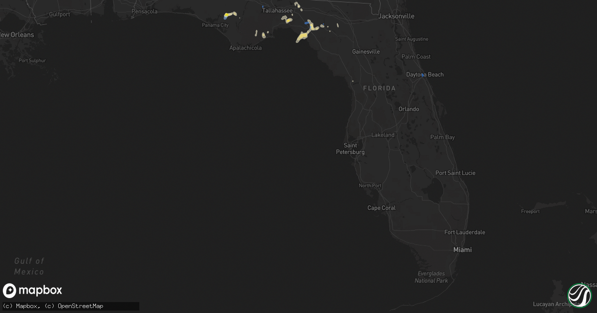
Hail Map in Florida on September 18, 2019
Get this storm
September 18 map
$229
one time, instant access
Download today. No call, no setup
Keep the $229
Bought the map and want the full workflow? Apply the entire $229 to a subscription within 7 days. None of it is wasted.
Every map, not just this one
This buys you this map. Subscription and you get every map we run, in the markets you choose from a few cities to whole states to nationwide. Plus real-time alerts the moment a storm fires.
Contact data
Name, contact info, occupancy, even credit band for addresses in the footprint. You go from where it hit to who to call.
Become the source they trust
Unlimited branding weather history reports on demand. You already have the documented answer ready for the property owner, and you are the one who showed up with it.
Property data and RoofTrace estimates
Pull up any address you have got, its value and the exact code rules for that jurisdiction, straight from One Click Code. Then RoofTrace estimates the squares, pitch, and roof value, priced the way you price.
Storm reports in Florida
Florida
| Date | Description |
|---|---|
| 09/18/20194:30 PM CDT | Several trees snapped south of i-10 along sr-267. |
| 09/18/20194:16 PM CDT | Fallen trees or limbs resulted in a power outage to 86 customers along roberts aman road. Reported via duke energy outage website. |
| 09/18/20194:06 PM CDT | Several trees and powerlines down with minor damage to roofs. |
| 09/18/20193:52 PM CDT | Fallen trees or limbs resulted in a power outage to 39 customers along county road 255a. Reported via duke energy outage website. |
| 09/18/20193:25 PM CDT | Trees in roadway at sr-59 and us-98 intersection. Time estimated by radar. |
| 09/18/20193:11 PM CDT | A few trees down near nw cr 251. |
| 09/18/20192:25 PM CDT | 72 mph/63 knot wind gust from the east-northeast at site fw3022... Back stretch of the daytona international speedway. |
| 09/18/20191:17 AM CDT | At 617 PM EDT, a severe thunderstorm was located over Mcalpin, or 11 miles south of Live Oak, moving south at 10 mph. HAZARD...60 mph wind gusts. SOURCE...Radar indicated. IMPACT...Expect damage to roofs, siding, and trees. Locations impacted include... Mcalpin and Obrien. |
| 09/18/201912:10 AM CDT | At 509 PM EDT, Doppler radar indicated a severe thunderstorm capable of producing damaging winds in excess of 60 mph. This storm was located near Monticello, and moving south at 30 mph. Penny size hail may also accompany the damaging winds. Locations impacted include... Monticello, Greenville, Casa Blanco, Moseley Hall, Ebb, Lamont, Aucilla, Nash, Sirmans and Drifton. |
| 09/17/201911:42 PM CDT | At 442 PM EDT, a severe thunderstorm was located near Perry, moving west at 10 mph. HAZARD...60 mph wind gusts. SOURCE...Radar indicated. IMPACT...Expect damage to roofs, siding, and trees. Locations impacted include... Perry, Perry-Foley Airport, Bucell Junction, Hampton Springs, Secotan and Boyd. |
| 09/17/201911:09 PM CDT | At 409 PM EDT, a severe thunderstorm was located 10 miles east of Woodville, moving southwest at 10 mph. HAZARD...60 mph wind gusts and quarter size hail. SOURCE...Radar indicated. IMPACT...Hail damage to vehicles is expected. Expect wind damage to roofs, siding, and trees. Locations impacted include... Woodville, Hells Half Acre, Natural Bridge, Fanlew and Plum Orchard. |
| 09/17/201911:07 PM CDT | At 407 PM EDT, a severe thunderstorm was located 8 miles west of Luraville, or 9 miles northwest of Mayo, moving south at 10 mph. HAZARD...60 mph wind gusts and quarter size hail. SOURCE...Radar indicated. IMPACT...Hail damage to vehicles is expected. Expect wind damage to roofs, siding, and trees. Locations impacted include... Townsend, Buckville, Day and Smith. |
| 09/17/201910:26 PM CDT | At 326 PM EDT, a severe thunderstorm was located over Daytona Beach Airport, or near Daytona Beach, moving southwest at 20 mph. HAZARD...60 mph wind gusts. SOURCE...Radar indicated. IMPACT...Expect damage to roofs, siding, and trees. Locations impacted include... Daytona Beach, Port Orange, DeLand, New Smyrna Beach and South Daytona. |
All States Impacted by Hail Map on September 18, 2019
Cities Impacted by Hail Map on September 18, 2019
- Tigerton, WI
- Center Point, IA
- Emerson, NE
- Hubbard, NE
- Craig, NE
- Madison, NE
- North Bend, NE
- Dodge, NE
- Howells, NE
- Oakland, NE
- Montezuma, IA
- Searsboro, IA
- Galesville, WI
- Fairmont, MN
- Granada, MN
- Fremont, NE
- Ashland, NE
- Ithaca, NE
- Buffalo Center, IA
- Lakota, IA
- Clermont, IA
- Elgin, IA
- Postville, IA
- Hoskins, NE
- Pender, NE
- Osmond, NE
- Carroll, NE
- Thurston, NE
- Pilger, NE
- Pierce, NE
- Wakefield, NE
- Randolph, NE
- Norfolk, NE
- Mclean, NE
- Wayne, NE
- Winside, NE
- Stanton, NE
- Wisner, NE
- Neligh, NE
- Pampa, TX
- Anahuac, TX
- Winnie, TX
- Greenville, IA
- Webb, IA
- Sutherland, IA
- Hartley, IA
- Le Mars, IA
- Scotia, NE
- Ericson, NE
- Ord, NE
- Batavia, IA
- Eldon, IA
- Ottumwa, IA
- Agency, IA
- Youngstown, FL
- Panama City, FL
- Perry, FL
- Epworth, IA
- Valley, NE
- Nickerson, NE
- Mead, NE
- Arlington, NE
- Lincoln, NE
- Waverly, NE
- Adams, NE
- Hickman, NE
- Firth, NE
- Walton, NE
- Palmyra, NE
- Alvo, NE
- Greenwood, NE
- Elmwood, NE
- Cortland, NE
- Panama, NE
- Eagle, NE
- Bennet, NE
- Blencoe, IA
- Orchard, NE
- Clearwater, NE
- Reinbeck, IA
- Traer, IA
- Hudson, IA
- Farley, IA
- Scribner, NE
- Britt, IA
- Dorchester, IA
- Decorah, IA
- Elma, IA
- Sigourney, IA
- Hedrick, IA
- Ely, IA
- Mount Vernon, IA
- West Point, NE
- Guttenberg, IA
- Dow City, IA
- Charter Oak, IA
- Ute, IA
- Whigham, GA
- Denison, IA
- Soldier, IA
- Dunlap, IA
- Wallace, MI
- Lanesboro, MN
- Preston, MN
- Live Oak, FL
- Nora Springs, IA
- Rockwell, IA
- Lyons, NE
- Pocahontas, IA
- Rolfe, IA
- West Union, IA
- Fayette, IA
- New Sharon, IA
- Barnes City, IA
- New Vienna, IA
- Thompson, IA
- McAlpin, FL
- Buckingham, IA
- Kennard, NE
- Elkhorn, NE
- Bennington, NE
- Lamont, FL
- Plainview, NE
- Holy Cross, IA
- Riceville, IA
- Truesdale, IA
- Storm Lake, IA
- Hosford, FL
- Holmen, WI
- Onalaska, WI
- La Crescent, MN
- Brownsville, MN
- Hokah, MN
- Wilton, WI
- Arion, IA
- Sopchoppy, FL
- Dyersville, IA
- Floris, IA
- Mayo, FL
- Viroqua, WI
- Pelham, GA
- Thomasville, GA
- Norwalk, WI
- Ontario, WI
- Tomah, WI
- Kasson, MN
- Roca, NE
- Pisgah, IA
- Moorhead, IA
- Lancaster, WI
- Curlew, IA
- Miami, TX
- Woden, IA
- Crystal Lake, IA
- Oakdale, NE
- Elgin, NE
- Houston, MN
- Groom, TX
- Blountstown, FL
- Oskaloosa, IA
- Conroe, TX
- Chambers, NE
- Burwell, NE
- La Porte City, IA
- Emmons, MN
- Alden, MN
- Wells, MN
- Kiester, MN
- Eddyville, IA
- Lime Springs, IA
- Harmony, MN
- Chester, IA
- Le Roy, MN
- Corwith, IA
- Dysart, IA
- Leigh, NE
- Brunswick, NE
- Caledonia, MN
- Spring Grove, MN
- Bartlett, NE
- Burt, IA
- Earling, IA
- Defiance, IA
- Clarkson, NE
- Tallahassee, FL
- Monticello, FL
- Crawfordville, FL
- Osage, IA
- Carrabelle, FL
- Inglis, FL
- Creston, NE
- Cassville, WI
- Sioux Rapids, IA
- Belden, NE
- Waterbury, NE
- Bancroft, NE
- Gladbrook, IA
- Waterloo, IA
- Clarksville, FL
- Peterson, MN
- Rushford, MN
- Monroe City, MO
- Palmyra, MO
- Albert Lea, MN
- Onawa, IA
- Milford, IA
- Tekamah, NE
- Spencer, IA
- Royal, IA
- Kanawha, IA
- Rosalie, NE
- Day, FL
- Lake Mills, IA
- Northwood, IA
- Blair, NE
- Saint Marys, GA
- Whittemore, IA
- Algona, IA
- Hooper, NE
- Herman, NE
- Mabel, MN
- Galva, IA
- Alta, IA
- Wisconsin Dells, WI
- Lyndon Station, WI
- Yutan, NE
- Omaha, NE
- Louise, TX
- El Campo, TX
- Royal, NE
- Memphis, NE
- Ewing, NE
- Frost, MN
- Ettrick, WI
- Everly, IA
- Lake Park, IA
- La Crosse, WI
- West Salem, WI
- Glen Haven, WI
- Bloomington, WI
- Oneill, NE
- Sioux City, IA
- Hinton, IA
- Zwingle, IA
- East Dubuque, IL
- La Motte, IA
- Dubuque, IA
- Schuyler, NE
- Beemer, NE
- Rogers, NE
- Snyder, NE
- Grand Marsh, WI
- Waterloo, NE
- Decatur, NE
- Wallisville, TX
- Devers, TX
- Hankamer, TX
- Vinton, IA
- Cresco, IA
- Ionia, IA
- Alta Vista, IA
- Charles City, IA
- Brandon, IA
- Quincy, FL
- Daytona Beach, FL
- Crosby, TX
- Baytown, TX
- Bussey, IA


