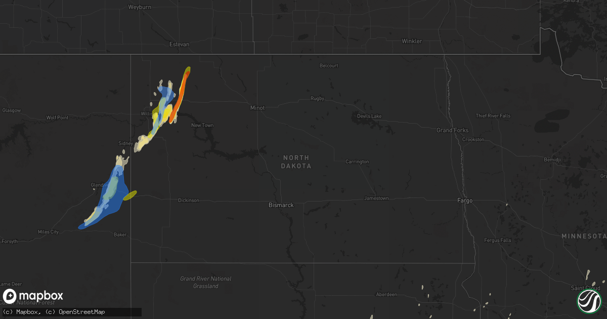
Hail Map in North Dakota on September 17, 2019
Get this storm
September 17 map
$229
one time, instant access
Download today. No call, no setup
Keep the $229
Bought the map and want the full workflow? Apply the entire $229 to a subscription within 7 days. None of it is wasted.
Every map, not just this one
This buys you this map. Subscription and you get every map we run, in the markets you choose from a few cities to whole states to nationwide. Plus real-time alerts the moment a storm fires.
Contact data
Name, contact info, occupancy, even credit band for addresses in the footprint. You go from where it hit to who to call.
Become the source they trust
Unlimited branding weather history reports on demand. You already have the documented answer ready for the property owner, and you are the one who showed up with it.
Property data and RoofTrace estimates
Pull up any address you have got, its value and the exact code rules for that jurisdiction, straight from One Click Code. Then RoofTrace estimates the squares, pitch, and roof value, priced the way you price.
Storm reports in North Dakota
North Dakota
| Date | Description |
|---|---|
| 09/17/20195:24 AM CDT | At 1024 PM CDT, severe thunderstorms were located along a line extending from 9 miles west of Alamo to near Wildrose to 6 miles northeast of Tioga, moving north at 45 mph. HAZARD...60 mph wind gusts and quarter size hail. SOURCE...Radar indicated. IMPACT...Hail damage to vehicles is expected. Expect wind damage to roofs, siding, and trees. Severe thunderstorms will be near... Wildrose around 1030 PM CDT. Powers Lake and Battleview around 1035 PM CDT. Crosby and Noonan around 1050 PM CDT. Lignite and Columbus around 1110 PM CDT. Portal around 1120 PM CDT.Other locations impacted by these severe thunderstorms includeHamlet, White Earth, Zahl, Appam, Larson, Mcgregor, Ambrose andCorinth. |
| 09/17/20194:44 AM CDT | At 944 PM CDT, severe thunderstorms were located along a line extending from 18 miles south of Ray to 4 miles southwest of Epping to 5 miles northwest of Williston, moving north at 40 mph. HAZARD...Ping pong ball size hail and 60 mph wind gusts. SOURCE...Radar indicated. IMPACT...People and animals outdoors will be injured. Expect hail damage to roofs, siding, windows, and vehicles. Expect wind damage to roofs, siding, and trees. Severe thunderstorms will be near... Epping around 950 PM CDT. Ray around 1000 PM CDT. Tioga around 1015 PM CDT. Wildrose and Alamo around 1025 PM CDT.Other locations impacted by these severe thunderstorms includeHamlet, Zahl, Lewis And Clark State Park, Appam, Spring Brook, WhiteTail Bay Recreation Area, Wheelock, Hanks, Mcgregor and TobaccoGarden Bay Recreation Area. |
| 09/17/20191:34 AM CDT | At 634 PM MDT, a severe thunderstorm was located 11 miles west of Wibaux, moving northeast at 35 mph. HAZARD...60 mph wind gusts and nickel size hail. SOURCE...Radar indicated. IMPACT...Expect damage to roofs, siding, and trees. Locations impacted include... Wibaux, Skaar, Hodges and Yates. |
| 09/17/20191:32 AM CDT | At 632 PM MDT, a severe thunderstorm was located near Wibaux, moving northeast at 45 mph. HAZARD...60 mph wind gusts and quarter size hail. SOURCE...Radar indicated. IMPACT...Hail damage to vehicles is expected. Expect wind damage to roofs, siding, and trees. Locations impacted include... Beach, Sentinel Butte and Trotters. |
| 09/16/201910:30 PM CDT | Report via social media with picture. |
| 09/16/20199:57 PM CDT | Large tree branches down. Hail to half dollar size ongoing. |
| 09/16/20199:57 PM CDT | 60 mph winds also estimated. Hail ongoing. |
| 09/16/20199:42 PM CDT | 2 miles south of lewis and clark state park. Time estimated by radar. |
| 09/16/20199:12 PM CDT | Report via social media. Time estimated by radar. |
| 09/16/20197:38 PM CDT | Time estimated by radar. |
All States Impacted by Hail Map on September 17, 2019
Cities Impacted by Hail Map on September 17, 2019
- Makinen, MN
- Cotton, MN
- Ely, MN
- Hinckley, MN
- Brook Park, MN
- Pierre, SD
- Harrold, SD
- Bay City, TX
- Aurora, MN
- Glendive, MT
- Savage, MT
- Wibaux, MT
- Fallon, MT
- Ismay, MT
- Epping, ND
- Ree Heights, SD
- Chokio, MN
- Milan, MN
- Cartwright, ND
- Mcgregor, ND
- Wildrose, ND
- Ray, ND
- Powers Lake, ND
- Williston, ND
- Tioga, ND
- New Town, ND
- Watford City, ND
- Lakefield, MN
- Estherville, IA
- Ortonville, MN
- Odessa, MN
- Windom, MN
- Kennebec, SD
- Presho, SD
- Roslyn, SD
- Langford, SD
- Sandstone, MN
- Ocheyedan, IA
- Arnegard, ND
- Alexander, ND
- Foley, MN
- Oak Park, MN
- Gilbert, MN
- Hulett, WY
- Babbitt, MN
- Sidney, MT
- Highmore, SD
- Sutherland, IA
- Peterson, IA
- Harris, IA
- Lake Park, IA
- Milbank, SD
- Northville, SD
- Archer, IA
- Holabird, SD
- Sauk Rapids, MN
- Ruthven, IA
- Ayrshire, IA
- Dolliver, IA
- Rozet, WY
- Spirit Lake, IA
- Sanborn, IA
- Melvin, IA
- Rice, MN
- Keystone, SD
- Detroit Lakes, MN
- Okoboji, IA
- Hartley, IA
- Hanley Falls, MN
- Granite Falls, MN
- Bradley, SD
- Faulkton, SD
- Orient, SD
- Jackson, MN
- Webster, SD
- Matagorda, TX
- Rapid City, SD
- Webb, IA
- Alamo, ND
- Bristol, SD
- Madison, MN
- Montevideo, MN
- Cresbard, SD
- Columbus, ND
- Sentinel Butte, ND
- Beach, ND
- Plevna, MT
- Baker, MT
- Tower, MN
- Blue Ridge, TX
- Trenton, TX
- Van Alstyne, TX
- Whitewright, TX
- Anna, TX
- Denison, TX
- Sherman, TX
- Savoy, TX
- Leonard, TX
- Bells, TX
- Farmersville, TX
- Princeton, TX
- Box Elder, SD
- Meeker, CO
- Craig, CO


