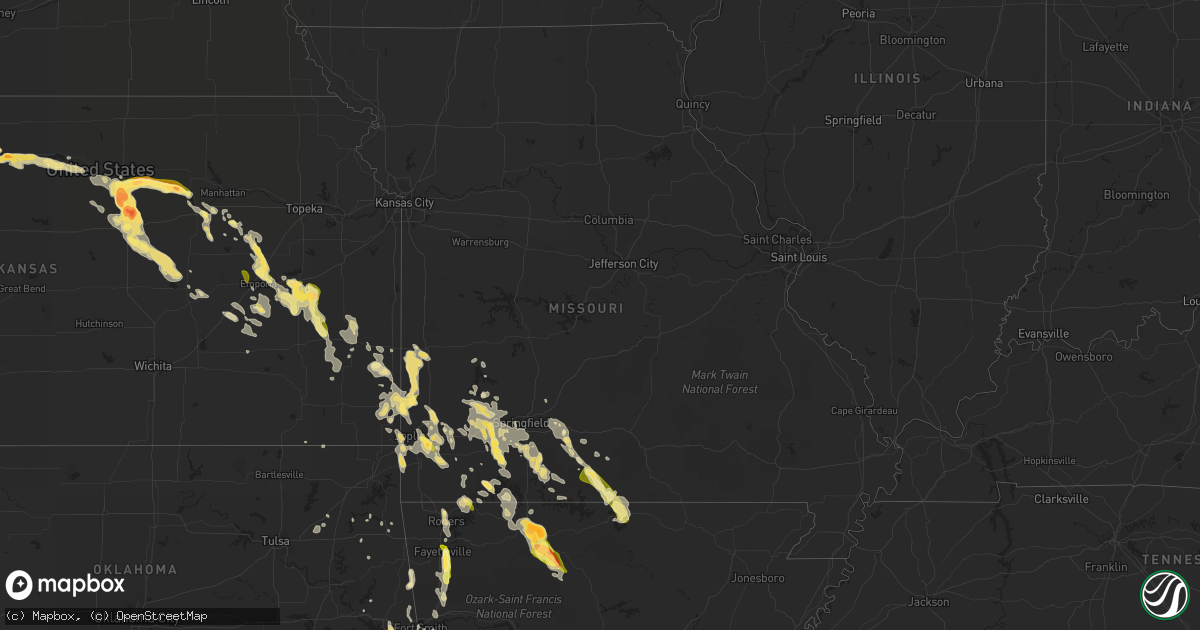
Hail Map in Missouri on September 17, 2014
Get this storm
September 17 map
$229
one time, instant access
Download today. No call, no setup
Keep the $229
Bought the map and want the full workflow? Apply the entire $229 to a subscription within 7 days. None of it is wasted.
Every map, not just this one
This buys you this map. Subscription and you get every map we run, in the markets you choose from a few cities to whole states to nationwide. Plus real-time alerts the moment a storm fires.
Contact data
Name, contact info, occupancy, even credit band for addresses in the footprint. You go from where it hit to who to call.
Become the source they trust
Unlimited branding weather history reports on demand. You already have the documented answer ready for the property owner, and you are the one who showed up with it.
Property data and RoofTrace estimates
Pull up any address you have got, its value and the exact code rules for that jurisdiction, straight from One Click Code. Then RoofTrace estimates the squares, pitch, and roof value, priced the way you price.
Storm reports in Missouri
Missouri
| Date | Description |
|---|---|
| 09/17/20142:05 PM CDT | A local report indicates 1.00 inch wind near SHELL KNOB |
| 09/17/20141:36 PM CDT | Fire department reports nickel to quarter size hail. |
| 09/17/20141:00 PM CDT | Power poles down on highway m |
| 09/17/20141:00 PM CDT | Tree and powerline down |
| 09/17/201412:58 PM CDT | A local report indicates 1.00 inch wind near 3 S HALLTOWN |
| 09/17/201412:56 PM CDT | A local report indicates 1.00 inch wind near 3 W WILLHOIT |
| 09/17/201412:08 PM CDT | Tree down along highway bb south of seymour near webster douglas county line. |
All States Impacted by Hail Map on September 17, 2014
Cities Impacted by Hail Map on September 17, 2014
- Ava, MO
- Squires, MO
- Seymour, MO
- Marion, KS
- Cedar Point, KS
- Clay Center, KS
- Wakefield, KS
- Shallowater, TX
- Snyder, TX
- Justiceburg, TX
- Salina, KS
- Varnville, SC
- Hampton, SC
- Early Branch, SC
- Estill, SC
- Ridgeland, SC
- Shell Knob, MO
- Aurora, MO
- Cassville, MO
- Miltonvale, KS
- Delphos, KS
- Waycross, GA
- Olpe, KS
- Hartford, KS
- Madison, KS
- Boswell, OK
- Tescott, KS
- Monett, MO
- Hardeeville, SC
- Waynesboro, GA
- Carthage, MO
- Jasper, MO
- Moran, KS
- Kincaid, KS
- Bronson, KS
- Glen Elder, KS
- Orangeburg, SC
- Cordova, SC
- Cope, SC
- Allen, KS
- Emporia, KS
- Humboldt, KS
- Chanute, KS
- Westphalia, KS
- Waverly, KS
- Eskridge, KS
- Burlington, KS
- Lebo, KS
- Admire, KS
- Erie, KS
- Americus, KS
- Colony, KS
- Savonburg, KS
- Alta Vista, KS
- Neosho Falls, KS
- Iola, KS
- Reading, KS
- Le Roy, KS
- Neosho Rapids, KS
- Alma, KS
- Post, TX
- Lorenzo, TX
- Ralls, TX
- Eureka, KS
- Seligman, MO
- Garfield, AR
- Bowman, SC
- Minneapolis, KS
- Mountainburg, AR
- Everton, MO
- Ash Grove, MO
- Roland, OK
- Muldrow, OK
- Aiken, SC
- New Ellenton, SC
- Assaria, KS
- Longford, KS
- Milford, KS
- Solomon, KS
- New Cambria, KS
- Hope, KS
- Abilene, KS
- Glasco, KS
- Bennington, KS
- Ramona, KS
- Lincolnville, KS
- Beloit, KS
- Hillsboro, KS
- Durham, KS
- Gypsum, KS
- Tampa, KS
- South Greenfield, MO
- White City, KS
- Junction City, KS
- Girard, GA
- Alton, KS
- Walnut Grove, MO
- Asbury, MO
- Moundville, MO
- Nevada, MO
- Milo, MO
- Nixa, MO
- Crane, MO
- Taneyville, MO
- Chadwick, MO
- Chestnutridge, MO
- Ozark, MO
- Bradleyville, MO
- Billings, MO
- Brookline, MO
- Marionville, MO
- Lockwood, MO
- Bois D Arc, MO
- Halltown, MO
- Willard, MO
- Galena, MO
- Springfield, MO
- Greenfield, MO
- Miller, MO
- Walnut Shade, MO
- Sparta, MO
- Garrison, MO
- Mount Vernon, MO
- Forsyth, MO
- Highlandville, MO
- Kissee Mills, MO
- Cape Fair, MO
- Republic, MO
- Clever, MO
- Rogersville, MO
- Nashoba, OK
- Anton, TX
- New Deal, TX
- Idalou, TX
- Lubbock, TX
- Tillman, SC
- Pineland, SC
- Stark City, MO
- Granby, MO
- Fairview, MO
- Joplin, MO
- Springdale, AR
- Rogers, AR
- Pea Ridge, AR
- Bentonville, AR
- Lowell, AR
- Wasola, MO
- Sudan, TX
- Amherst, TX
- Redfield, KS
- Fort Scott, KS
- Glade, KS
- Seneca, MO
- Wyandotte, OK
- North Augusta, SC
- Green Forest, AR
- Girard, KS
- Poteau, OK
- Heavener, OK
- Howe, OK
- Osborne, KS
- Exeter, MO
- Washburn, MO
- Sheldon, MO
- Liberal, MO
- Opolis, KS
- Frontenac, KS
- Pittsburg, KS
- Mindenmines, MO
- Lamar, MO
- Webb City, MO
- Oronogo, MO
- Deerfield, MO
- Bronaugh, MO
- Gainesville, MO
- Noble, MO
- Waldron, AR
- Fort Smith, AR
- Downs, KS
- Woodston, KS
- Portis, KS
- Ira, TX
- Slaton, TX
- Uniontown, KS
- Gaylord, KS
- Cameron, OK
- Hackett, AR
- Udall, MO
- Tecumseh, MO
- Hardenville, MO
- Gans, OK
- Claremore, OK
- Fayetteville, AR
- West Fork, AR
- Hamilton, KS
- Wentworth, MO
- Fluvanna, TX
- Harrison, AR
- Abernathy, TX
- Fordland, MO
- Tipton, KS
- Kirwin, KS
- Winslow, AR
- Manhattan, KS
- Neosho, MO
- Quapaw, OK
- Galena, KS
- Diamond, MO
- Weir, KS
- Scammon, KS
- Sarcoxie, MO
- Reeds, MO
- Graniteville, SC
- Coffeyville, KS
- S Coffeyville, OK
- Stockton, MO
- Saint Joe, AR
- Everton, AR
- Western Grove, AR
- Hasty, AR
- Brunswick, GA
- Stotts City, MO
- Pierce City, MO
- La Russell, MO
- Avilla, MO
- Alpena, AR
- Rincon, GA
- Lampe, MO
- Blue Eye, MO
- Ridgeville, SC
- Gamaliel, AR
- Pryor, OK
- Vian, OK
- Gore, OK
- Carterville, MO
- Stella, MO
- Duenweg, MO
- Mount Judea, AR
- Marble Falls, AR
- Rattan, OK
- Gepp, AR
- Henderson, AR
- Cottageville, SC
- Pocola, OK
- Lincoln, KS
- Purdy, MO
- Clarkridge, AR
- Thornfield, MO
- Viola, AR
- Mountain Home, AR
- Elizabeth, AR
- Bakersfield, MO
- Marshfield, MO
- Brixey, MO
- Olar, SC
- Denmark, SC
- Bamberg, SC
- Rudy, AR
- Alma, AR
- Farlington, KS
- Spiro, OK
- Stilwell, OK
- Natural Dam, AR
- Lincoln, AR
- Canehill, AR
- Evansville, AR
- Moncks Corner, SC
- Bonneau, SC
- Round O, SC
- Matfield Green, KS
- Salina, OK
- Hepler, KS
- Arcadia, KS
- Eureka Springs, AR
- Sallisaw, OK
- Broken Bow, OK
- Oak Grove, AR
- Maple Hill, NC
- Colcord, OK
- Drury, MO
- Rowesville, SC
- Neeses, SC
- La Harpe, KS
- Mansfield, AR
- Garnett, SC
- Carl Junction, MO
- Arma, KS
- Mulberry, KS
- Columbus, KS
- Cherokee, KS
- Franklin, KS
- Inola, OK
- Mulberry, AR
- Chester, AR
- Arkoma, OK
- Fort Riley, KS
- Riley, KS
- Eagle Rock, MO
- Golden, MO
- Fairfax, SC
- Brunson, SC
- Huntington, AR
- Greenwood, AR
- Council Grove, KS
- Big Timber, MT
- Elmdale, KS
- Elkland, MO
- Omaha, AR
- Protem, MO
- Augusta, GA
- Phillipsburg, KS
- Van Buren, AR
- Lavaca, AR
- Tahlequah, OK
- Dillon, MT
- Vendor, AR
- Jasper, AR
- Kimberling City, MO
- Marshall, AR
- Berryville, AR
- Norwood, MO
- Dadeville, MO
- Elsmore, KS
- Fair Play, MO
- Rose, OK
- Austin, TX
- Stockton, KS
- Rueter, MO
- Eucha, OK
- Caulfield, MO
- Pindall, AR
- Richlands, NC
- Levelland, TX
- Smyer, TX
- Garnett, KS


