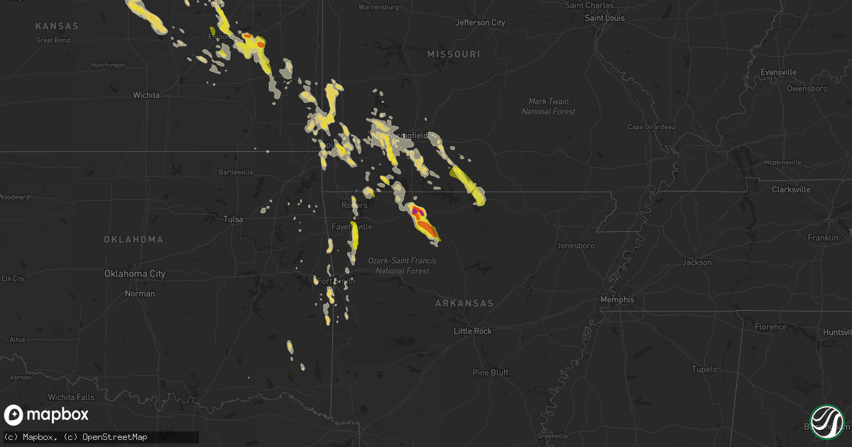
Hail Map on September 17, 2014
Get this storm
September 17 map
$229
one time, instant access
Download today. No call, no setup
Keep the $229
Bought the map and want the full workflow? Apply the entire $229 to a subscription within 7 days. None of it is wasted.
Every map, not just this one
This buys you this map. Subscription and you get every map we run, in the markets you choose from a few cities to whole states to nationwide. Plus real-time alerts the moment a storm fires.
Contact data
Name, contact info, occupancy, even credit band for addresses in the footprint. You go from where it hit to who to call.
Become the source they trust
Unlimited branding weather history reports on demand. You already have the documented answer ready for the property owner, and you are the one who showed up with it.
Property data and RoofTrace estimates
Pull up any address you have got, its value and the exact code rules for that jurisdiction, straight from One Click Code. Then RoofTrace estimates the squares, pitch, and roof value, priced the way you price.
States Impacted by Hail Map on September 17, 2014
Storm reports
North Carolina
| Date | Description |
|---|---|
| 09/17/20144:15 PM CDT | A local report indicates 1.00 inch wind near 3 WNW CATHERINE LAKE |
South Carolina
| Date | Description |
|---|---|
| 09/17/20145:44 PM CDT | Warning point reported 2 trees down...one at the intersection of tillman road and cotton hill road. The other at tillman road and tarboro road. |
| 09/17/20145:44 PM CDT | Warning point reported 2 trees down...one at the intersection of tillman road and cotton hill road. The other at tillman road and tarboro road. |
| 09/17/20144:41 PM CDT | Warning point reported tree down on pine level church road. |
| 09/17/20143:59 PM CDT | Quarter size hail on hwy 301 at legrand smoak st. |
| 09/17/20143:55 PM CDT | Warning point reported tree down at the intersection of lake warren road and luray highway. |
| 09/17/20143:45 PM CDT | Orangeburg dispatch reported powerlines downed on norway rd. Time estimated by radar. |
| 09/17/20143:35 PM CDT | Report of quarter-size hail in bamberg |
Missouri
| Date | Description |
|---|---|
| 09/17/20142:05 PM CDT | A local report indicates 1.00 inch wind near SHELL KNOB |
| 09/17/20141:36 PM CDT | Fire department reports nickel to quarter size hail. |
| 09/17/20141:00 PM CDT | Power poles down on highway m |
| 09/17/20141:00 PM CDT | Tree and powerline down |
| 09/17/201412:58 PM CDT | A local report indicates 1.00 inch wind near 3 S HALLTOWN |
| 09/17/201412:56 PM CDT | A local report indicates 1.00 inch wind near 3 W WILLHOIT |
| 09/17/201412:08 PM CDT | Tree down along highway bb south of seymour near webster douglas county line. |
Kansas
| Date | Description |
|---|---|
| 09/17/20143:20 AM CDT | Time estimated based on radar data |
| 09/17/20142:30 AM CDT | A local report indicates 1.00 inch wind near 8 S WAVERLY |
| 09/17/20141:50 AM CDT | Multiple reports of hail in and near bennington of hail from golfball up to tennis ball size. |
| 09/17/20141:45 AM CDT | Report via social media photo. Time estimated based on radar. |
| 09/17/20141:35 AM CDT | Quarter to half dollar size hail reported via social media. |
| 09/17/20141:35 AM CDT | A local report indicates 1.75 inch wind near 5 NW WAKEFIELD |
| 09/17/20141:21 AM CDT | A local report indicates 1.75 inch wind near NNE MINNEAPOLIS |
| 09/17/20141:20 AM CDT | Numerous photos via social media indicated hail up to 2.5 inches in diameter fell in the city of minneapolis. |
| 09/17/201412:35 AM CDT | Hail lasted about 15 minutes. Caused damage to vehicles...siding on south and west sides of home...roof...and crops. |
| 09/16/201411:30 PM CDT | A local report indicates 1.75 inch wind near 2 NE ALTON |
Oklahoma
| Date | Description |
|---|---|
| 09/16/201410:25 PM CDT | Small trees and power lines down 2 miles east of leflore. |
| 09/16/201410:10 PM CDT | Large trees down in the haw creek community. |
Nevada
| Date | Description |
|---|---|
| 09/16/201410:11 PM CDT | Thunderstorm produced 66 mph gust at rock spring creek raws |
Arkansas
| Date | Description |
|---|---|
| 09/17/20146:00 PM CDT | A local report indicates 1.00 inch wind near FAYETTEVILLE |
| 09/17/20144:59 PM CDT | Downed power line in rogers. Social media report with picture. |
| 09/17/20144:50 PM CDT | Tree damage from thunderstorm winds in little flock. Socila media report with picture. |
| 09/17/20144:23 PM CDT | Fourteen inch diameter trees down. |
| 09/17/20143:30 PM CDT | Large tree blocking highway 123 near the highway 74 intersection. |
| 09/17/20143:15 PM CDT | A local report indicates 1.25 inch wind near HARRISON |
| 09/17/20143:10 PM CDT | Quarter sized hail fell for about 10 minutes. |
| 09/17/20143:10 PM CDT | A local report indicates 2.00 inch wind near 2 SE HARRISON |
| 09/17/20143:06 PM CDT | Hail started out as penny size...increased to nickel size...and now golfball sized hail is falling. |
| 09/17/20143:02 PM CDT | Reported there was a lot of hail. |
| 09/17/20141:39 PM CDT | A tree was blown down onto a county road...and a number of large limbs were blown down. |
Cities Impacted by Hail Map on September 17, 2014
- Ava, MO
- Squires, MO
- Seymour, MO
- Marion, KS
- Cedar Point, KS
- Clay Center, KS
- Wakefield, KS
- Shallowater, TX
- Snyder, TX
- Justiceburg, TX
- Salina, KS
- Varnville, SC
- Hampton, SC
- Early Branch, SC
- Estill, SC
- Ridgeland, SC
- Shell Knob, MO
- Aurora, MO
- Cassville, MO
- Miltonvale, KS
- Delphos, KS
- Waycross, GA
- Olpe, KS
- Hartford, KS
- Madison, KS
- Boswell, OK
- Tescott, KS
- Monett, MO
- Hardeeville, SC
- Waynesboro, GA
- Carthage, MO
- Jasper, MO
- Moran, KS
- Kincaid, KS
- Bronson, KS
- Glen Elder, KS
- Orangeburg, SC
- Cordova, SC
- Cope, SC
- Allen, KS
- Emporia, KS
- Humboldt, KS
- Chanute, KS
- Westphalia, KS
- Waverly, KS
- Eskridge, KS
- Burlington, KS
- Lebo, KS
- Admire, KS
- Erie, KS
- Americus, KS
- Colony, KS
- Savonburg, KS
- Alta Vista, KS
- Neosho Falls, KS
- Iola, KS
- Reading, KS
- Le Roy, KS
- Neosho Rapids, KS
- Alma, KS
- Post, TX
- Lorenzo, TX
- Ralls, TX
- Eureka, KS
- Seligman, MO
- Garfield, AR
- Bowman, SC
- Minneapolis, KS
- Mountainburg, AR
- Everton, MO
- Ash Grove, MO
- Roland, OK
- Muldrow, OK
- Aiken, SC
- New Ellenton, SC
- Assaria, KS
- Longford, KS
- Milford, KS
- Solomon, KS
- New Cambria, KS
- Hope, KS
- Abilene, KS
- Glasco, KS
- Bennington, KS
- Ramona, KS
- Lincolnville, KS
- Beloit, KS
- Hillsboro, KS
- Durham, KS
- Gypsum, KS
- Tampa, KS
- South Greenfield, MO
- White City, KS
- Junction City, KS
- Girard, GA
- Alton, KS
- Walnut Grove, MO
- Asbury, MO
- Moundville, MO
- Nevada, MO
- Milo, MO
- Nixa, MO
- Crane, MO
- Taneyville, MO
- Chadwick, MO
- Chestnutridge, MO
- Ozark, MO
- Bradleyville, MO
- Billings, MO
- Brookline, MO
- Marionville, MO
- Lockwood, MO
- Bois D Arc, MO
- Halltown, MO
- Willard, MO
- Galena, MO
- Springfield, MO
- Greenfield, MO
- Miller, MO
- Walnut Shade, MO
- Sparta, MO
- Garrison, MO
- Mount Vernon, MO
- Forsyth, MO
- Highlandville, MO
- Kissee Mills, MO
- Cape Fair, MO
- Republic, MO
- Clever, MO
- Rogersville, MO
- Nashoba, OK
- Anton, TX
- New Deal, TX
- Idalou, TX
- Lubbock, TX
- Tillman, SC
- Pineland, SC
- Stark City, MO
- Granby, MO
- Fairview, MO
- Joplin, MO
- Springdale, AR
- Rogers, AR
- Pea Ridge, AR
- Bentonville, AR
- Lowell, AR
- Wasola, MO
- Sudan, TX
- Amherst, TX
- Redfield, KS
- Fort Scott, KS
- Glade, KS
- Seneca, MO
- Wyandotte, OK
- North Augusta, SC
- Green Forest, AR
- Girard, KS
- Poteau, OK
- Heavener, OK
- Howe, OK
- Osborne, KS
- Exeter, MO
- Washburn, MO
- Sheldon, MO
- Liberal, MO
- Opolis, KS
- Frontenac, KS
- Pittsburg, KS
- Mindenmines, MO
- Lamar, MO
- Webb City, MO
- Oronogo, MO
- Deerfield, MO
- Bronaugh, MO
- Gainesville, MO
- Noble, MO
- Waldron, AR
- Fort Smith, AR
- Downs, KS
- Woodston, KS
- Portis, KS
- Ira, TX
- Slaton, TX
- Uniontown, KS
- Gaylord, KS
- Cameron, OK
- Hackett, AR
- Udall, MO
- Tecumseh, MO
- Hardenville, MO
- Gans, OK
- Claremore, OK
- Fayetteville, AR
- West Fork, AR
- Hamilton, KS
- Wentworth, MO
- Fluvanna, TX
- Harrison, AR
- Abernathy, TX
- Fordland, MO
- Tipton, KS
- Kirwin, KS
- Winslow, AR
- Manhattan, KS
- Neosho, MO
- Quapaw, OK
- Galena, KS
- Diamond, MO
- Weir, KS
- Scammon, KS
- Sarcoxie, MO
- Reeds, MO
- Graniteville, SC
- Coffeyville, KS
- S Coffeyville, OK
- Stockton, MO
- Saint Joe, AR
- Everton, AR
- Western Grove, AR
- Hasty, AR
- Brunswick, GA
- Stotts City, MO
- Pierce City, MO
- La Russell, MO
- Avilla, MO
- Alpena, AR
- Rincon, GA
- Lampe, MO
- Blue Eye, MO
- Ridgeville, SC
- Gamaliel, AR
- Pryor, OK
- Vian, OK
- Gore, OK
- Carterville, MO
- Stella, MO
- Duenweg, MO
- Mount Judea, AR
- Marble Falls, AR
- Rattan, OK
- Gepp, AR
- Henderson, AR
- Cottageville, SC
- Pocola, OK
- Lincoln, KS
- Purdy, MO
- Clarkridge, AR
- Thornfield, MO
- Viola, AR
- Mountain Home, AR
- Elizabeth, AR
- Bakersfield, MO
- Marshfield, MO
- Brixey, MO
- Olar, SC
- Denmark, SC
- Bamberg, SC
- Rudy, AR
- Alma, AR
- Farlington, KS
- Spiro, OK
- Stilwell, OK
- Natural Dam, AR
- Lincoln, AR
- Canehill, AR
- Evansville, AR
- Moncks Corner, SC
- Bonneau, SC
- Round O, SC
- Matfield Green, KS
- Salina, OK
- Hepler, KS
- Arcadia, KS
- Eureka Springs, AR
- Sallisaw, OK
- Broken Bow, OK
- Oak Grove, AR
- Maple Hill, NC
- Colcord, OK
- Drury, MO
- Rowesville, SC
- Neeses, SC
- La Harpe, KS
- Mansfield, AR
- Garnett, SC
- Carl Junction, MO
- Arma, KS
- Mulberry, KS
- Columbus, KS
- Cherokee, KS
- Franklin, KS
- Inola, OK
- Mulberry, AR
- Chester, AR
- Arkoma, OK
- Fort Riley, KS
- Riley, KS
- Eagle Rock, MO
- Golden, MO
- Fairfax, SC
- Brunson, SC
- Huntington, AR
- Greenwood, AR
- Council Grove, KS
- Big Timber, MT
- Elmdale, KS
- Elkland, MO
- Omaha, AR
- Protem, MO
- Augusta, GA
- Phillipsburg, KS
- Van Buren, AR
- Lavaca, AR
- Tahlequah, OK
- Dillon, MT
- Vendor, AR
- Jasper, AR
- Kimberling City, MO
- Marshall, AR
- Berryville, AR
- Norwood, MO
- Dadeville, MO
- Elsmore, KS
- Fair Play, MO
- Rose, OK
- Austin, TX
- Stockton, KS
- Rueter, MO
- Eucha, OK
- Caulfield, MO
- Pindall, AR
- Richlands, NC
- Levelland, TX
- Smyer, TX
- Garnett, KS