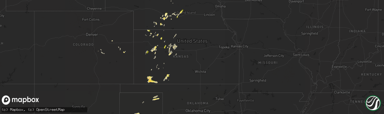
Hail Map in Kansas on September 15, 2022
The weather event in Kansas on September 15, 2022 includes Hail and Wind maps. 8 states and 120 cities were impacted and suffered possible damage. The total estimated number of properties impacted is 2,219.
Want more than just the map?
Turn this storm into a full workflow.
- Owner + property data so you know who to knock
- OnDemand branded weather history reports to win the "did we even have hail?" argument
- RoofTrace estimate so reps stop guessing numbers at the door
Bought this map? Upgrade within 7 days and we'll credit the $230. (10-15 min setup call)
Hail
Wind
2,219
Estimated number of impacted properties by a 1.00" hail or larger175
Estimated number of impacted properties by a 1.75" hail or larger0
Estimated number of impacted properties by a 2.50" hail or largerStorm reports in Kansas
Kansas
| Date | Description |
|---|---|
| 09/15/20226:46 PM CDT | A local report indicates 1.75 inch wind near 5 N LIBERAL |
| 09/15/20226:30 PM CDT | Tractor trailer blown over. |
| 09/15/20226:27 PM CDT | Report from mping: quarter |
| 09/15/20226:09 PM CDT | A local report indicates 1.00 inch wind near 12 SSE SATANTA |
| 09/15/20226:06 PM CDT | Two full kerosene tanks that were anchored down were blown into a field. Large tree limbs were downed. |
| 09/15/20224:21 AM CDT | At 921 PM CDT, a severe thunderstorm was located near Hill City, moving east at 10 mph. HAZARD...60 mph wind gusts. SOURCE...Trained weather spotters. IMPACT...Expect damage to roofs, siding, and trees. Locations impacted include... Bogue and Nicodemus. |
| 09/15/20222:49 AM CDT | At 749 PM CDT, a severe thunderstorm was located 7 miles south of Plains, or 7 miles southeast of Kismet, moving east at 15 mph. HAZARD...60 mph wind gusts and quarter size hail. SOURCE...Radar indicated. IMPACT...Hail damage to vehicles is expected. Expect wind damage to roofs, siding, and trees. Locations impacted include... Meade State Park. |
| 09/15/20222:09 AM CDT | At 708 PM CDT, a severe thunderstorm was located near Hayne, moving southeast at 15 mph. HAZARD...Two inch hail and 70 mph wind gusts. SOURCE...Law enforcement has reported golf ball size hail and wind damage from this storm. IMPACT...People and animals outdoors will be injured. Expect hail damage to roofs, siding, windows, and vehicles. Expect considerable tree damage. Wind damage is also likely to mobile homes, roofs, and outbuildings. Locations impacted include... Hayne. |
| 09/15/20221:53 AM CDT | At 652 PM CDT, a severe thunderstorm was located near Kismet, moving east at 30 mph. HAZARD...Golf ball size hail and 70 mph wind gusts. SOURCE...Law enforcement. Golfball hail was reported from this storm at 6:50 PM CDT. IMPACT...People and animals outdoors will be injured. Expect hail damage to roofs, siding, windows, and vehicles. Expect considerable tree damage. Wind damage is also likely to mobile homes, roofs, and outbuildings. This severe thunderstorm will be near... Kismet around 705 PM CDT.Other locations in the path of this severe thunderstorm includePlains. |
| 09/15/20221:50 AM CDT | At 649 PM CDT, a severe thunderstorm was located 7 miles northwest of Missler, moving east at 25 mph. HAZARD...60 mph wind gusts. SOURCE...Radar indicated. IMPACT...Expect damage to roofs, siding, and trees. This severe thunderstorm will be near... Missler around 705 PM CDT. |
| 09/15/20221:38 AM CDT | At 637 PM CDT, severe thunderstorms were located along a line extending from near Montezuma to near Meade State Park, moving east at 25 mph. HAZARD...70 mph wind gusts and nickel size hail. Radar indicates widespread blowing dust is occuring. SOURCE...Radar indicated. IMPACT...Expect considerable tree damage. Damage is likely to mobile homes, roofs, and outbuildings. Severe thunderstorms will be near... The Haggard Elev around 655 PM CDT.Other locations in the path of these severe thunderstorms includeEnsign. |
| 09/15/20221:22 AM CDT | At 621 PM CDT, a severe thunderstorm was located 7 miles west of Kismet, moving east at 30 mph. HAZARD...60 mph wind gusts and quarter size hail. SOURCE...Law enforcement. Quarter size hail was reported on US 83 north of Liberal. IMPACT...Hail damage to vehicles is expected. Expect wind damage to roofs, siding, and trees. This severe thunderstorm will be near... Kismet around 635 PM CDT.Other locations in the path of this severe thunderstorm includePlains. |
| 09/15/20221:14 AM CDT | At 613 PM CDT, a severe thunderstorm was located 8 miles south of Tice, moving east at 20 mph. HAZARD...Ping pong ball size hail and 60 mph wind gusts. Areas of blowing dust and limited visibility are expected. SOURCE...Radar indicated. IMPACT...People and animals outdoors will be injured. Expect hail damage to roofs, siding, windows, and vehicles. Expect wind damage to roofs, siding, and trees. Locations impacted include... Missler. |
| 09/15/202212:36 AM CDT | At 536 PM CDT, a severe thunderstorm was located near Satanta, moving east at 15 mph. HAZARD...60 mph wind gusts and quarter size hail. Areas of blowing dust and limited visibility are likely, especially near open fields. SOURCE...Radar indicated. IMPACT...Hail damage to vehicles is expected. Expect wind damage to roofs, siding, and trees. Locations impacted include... Sublette. |
| 09/15/202212:03 AM CDT | At 503 PM CDT, a severe thunderstorm was located near Clark State Lake, moving northeast at 20 mph. HAZARD...60 mph wind gusts and quarter size hail. SOURCE...Radar indicated. IMPACT...Hail damage to vehicles is expected. Expect wind damage to roofs, siding, and trees. Locations impacted include... Bucklin and Clark State Lake. |
| 09/14/202211:54 PM CDT | At 453 PM CDT, a severe thunderstorm was located near Schoenchen, moving northeast at 20 mph. HAZARD...60 mph wind gusts and quarter size hail. SOURCE...Radar indicated. IMPACT...Hail damage to vehicles is expected. Expect wind damage to roofs, siding, and trees. Locations impacted include... Hays, Schoenchen, Liebenthal, Yocemento, Pfeifer, Toulon, Munjor, Antonino and Loretta. |
| 09/14/20229:14 PM CDT | Asos station khlc hill city. |
| 09/14/20228:16 PM CDT | Mesonet station meuk1 meade 10 m wind gust. |
| 09/14/20227:33 PM CDT | Report from mping: 3-inch tree limbs broken; power poles broken. |
| 09/14/20227:11 PM CDT | Broken windshield. |
| 09/14/20227:03 PM CDT | A local report indicates 1.75 inch wind near 5 WNW HAYNE |
All States Impacted by Hail Map on September 15, 2022
Cities Impacted by Hail Map on September 15, 2022
- Primrose, NE
- McDonald, KS
- Rush, CO
- Burwell, NE
- Atwood, KS
- Oberlin, KS
- Wright, KS
- Selden, KS
- Ellis, KS
- Cimarron, KS
- Elm Creek, NE
- Overton, NE
- Perryton, TX
- Booker, TX
- Canadian, TX
- Amarillo, TX
- Maywood, NE
- McCook, NE
- Colorado Springs, CO
- Spalding, NE
- Ludell, KS
- Herndon, KS
- Kismet, KS
- Liberal, KS
- Satanta, KS
- Hugoton, KS
- Meade, KS
- Plains, KS
- Moscow, KS
- Sublette, KS
- Jennings, KS
- Dresden, KS
- Natoma, KS
- Catharine, KS
- Gorham, KS
- Victoria, KS
- Paradise, KS
- Plainville, KS
- Hays, KS
- Arcadia, NE
- Cambridge, NE
- Holbrook, NE
- Bucklin, KS
- Ashland, KS
- Mullinville, KS
- Englewood, KS
- Minneola, KS
- Morland, KS
- Leoti, KS
- Kit Carson, CO
- Otis, KS
- Eustis, NE
- Elwood, NE
- Lexington, NE
- Bertrand, NE
- Smithfield, NE
- Brownfield, TX
- Stockton, KS
- Albion, NE
- Stinnett, TX
- Winona, KS
- Clarendon, TX
- Cairo, NE
- Kearney, NE
- Ravenna, NE
- Shelton, NE
- Gibbon, NE
- Riverdale, NE
- Amherst, NE
- Jetmore, KS
- Welch, TX
- Seagraves, TX
- Cozad, NE
- McCracken, KS
- Park, KS
- Kiowa, CO
- Jordan Valley, OR
- Malta, ID
- Garden City, KS
- Wendover, UT
- Holdrege, NE
- Genoa, CO
- Limon, CO
- Higgins, TX
- Arapahoe, NE
- Kensington, KS
- Kirwin, KS
- Calhan, CO
- Dugway, UT
- Protection, KS
- Palco, KS
- Gove, KS
- Healy, KS
- Ingalls, KS
- Wakeeney, KS
- Pioche, NV
- Norton, KS
- Penokee, KS
- Hill City, KS
- Grinnell, KS
- Grainfield, KS
- Meadow, TX
- Dighton, KS
- Panhandle, TX
- Eddyville, NE
- Indianola, NE
- Claude, TX
- Pleasanton, NE
- Comstock, NE
- Curtis, NE
- Loop, TX
- Yoder, CO
- Scott City, KS
- Oakley, KS
- Ogallah, KS
- Minden, NE
- Wood River, NE
- Grand Island, NE
- Lubbock, TX
- Idalou, TX


