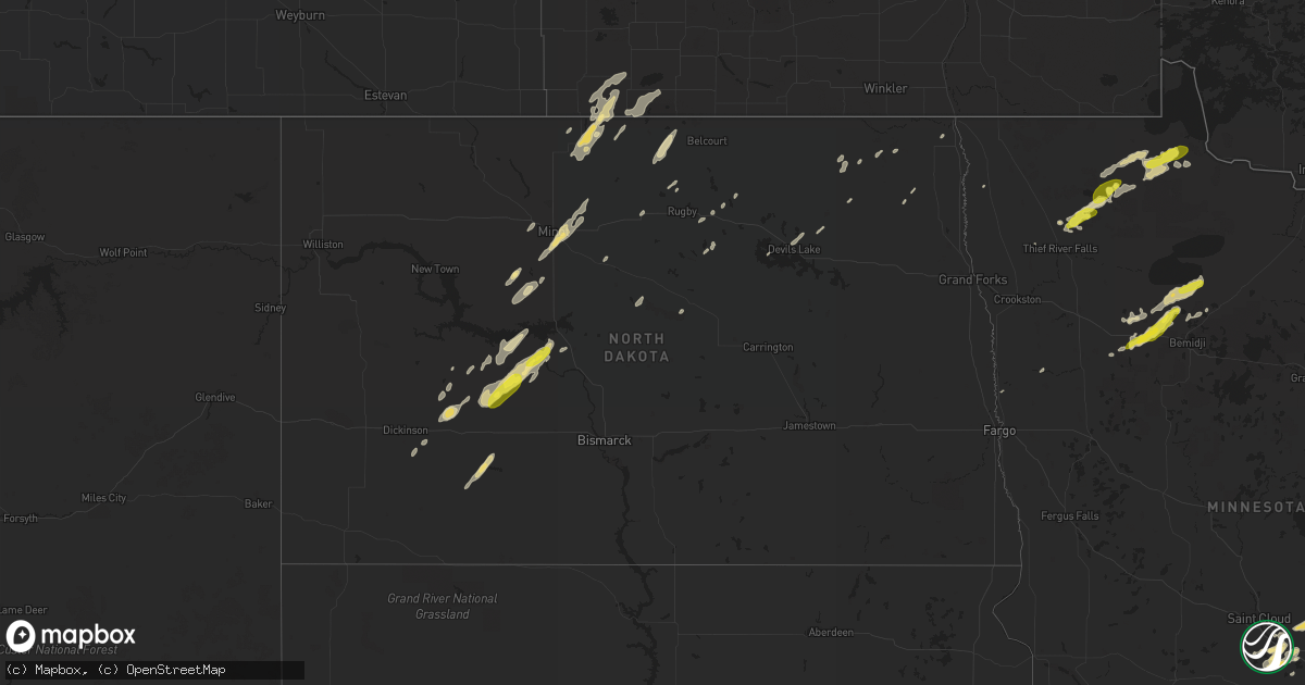
Hail Map in North Dakota on September 12, 2018
Get this storm
September 12 map
$229
one time, instant access
Download today. No call, no setup
Keep the $229
Bought the map and want the full workflow? Apply the entire $229 to a subscription within 7 days. None of it is wasted.
Every map, not just this one
This buys you this map. Subscription and you get every map we run, in the markets you choose from a few cities to whole states to nationwide. Plus real-time alerts the moment a storm fires.
Contact data
Name, contact info, occupancy, even credit band for addresses in the footprint. You go from where it hit to who to call.
Become the source they trust
Unlimited branding weather history reports on demand. You already have the documented answer ready for the property owner, and you are the one who showed up with it.
Property data and RoofTrace estimates
Pull up any address you have got, its value and the exact code rules for that jurisdiction, straight from One Click Code. Then RoofTrace estimates the squares, pitch, and roof value, priced the way you price.
Storm reports in North Dakota
North Dakota
| Date | Description |
|---|---|
| 09/12/20186:15 AM CDT | At 1114 PM CDT, a severe thunderstorm was located 6 miles southwest of Beulah, moving northeast at 55 mph. HAZARD...Quarter size hail. SOURCE...Radar indicated. IMPACT...Damage to vehicles is expected. This severe thunderstorm will be near... Beulah around 1125 PM CDT. Hazen around 1130 PM CDT. |
| 09/12/20186:09 AM CDT | At 1108 PM CDT, a severe thunderstorm was located near Beulah Bay Recreation Area, or 15 miles southwest of Garrison, moving northeast at 55 mph. HAZARD...Quarter size hail. SOURCE...Radar indicated. IMPACT...Damage to vehicles is expected. This severe thunderstorm will be near... Garrison and Fort Stevenson State Park around 1125 PM CDT. Max around 1140 PM CDT. Benedict around 1150 PM CDT.Other locations impacted by this severe thunderstorm include Ruso,Dakota Waters Recreation Area, Emmet and White Shield. |
| 09/11/201811:40 PM CDT | Hail estimated up to an inch in diameter. |
All States Impacted by Hail Map on September 12, 2018
Cities Impacted by Hail Map on September 12, 2018
- Orr, MN
- Grygla, MN
- Monticello, MN
- Anoka, MN
- Elk River, MN
- Drake, ND
- Middle River, MN
- Newfolden, MN
- Gatzke, MN
- Souris, ND
- Des Lacs, ND
- Burlington, ND
- Underwood, ND
- Zap, ND
- Hazen, ND
- Beulah, ND
- Stanton, ND
- South Haven, MN
- Big Lake, MN
- Roosevelt, MN
- Shevlin, MN
- Richardton, ND
- Halliday, ND
- Taylor, ND
- Clearbrook, MN
- Bagley, MN
- Leonard, MN
- Parrish, FL
- Tampa, FL
- Ryder, ND
- Redby, MN
- Puposky, MN
- Redlake, MN
- Blackduck, MN
- Osnabrock, ND
- Zimmerman, MN
- Georgetown, MN
- Clearwater, MN
- Annandale, MN
- Maple Lake, MN
- Newburg, ND
- Westhope, ND
- Maxbass, ND
- Douglas, ND
- Towner, ND
- Dunseith, ND
- Willow City, ND
- Knox, ND
- York, ND
- Thief River Falls, MN
- Solway, MN
- Bemidji, MN
- Cook, MN
- Esmond, ND
- Roseau, MN
- Glen Ullin, ND
- Mott, ND
- New Leipzig, ND
- Gladstone, ND
- Wannaska, MN
- Williams, MN
- Minot, ND
- Deering, ND
- Norwich, ND
- Surrey, ND
- Fairdale, ND
- Oberon, ND
- Becker, MN
- Princeton, MN
- Harvey, ND
- Lengby, MN
- Buffalo, MN
- Palmetto, FL
- Wimauma, FL
- Apollo Beach, FL
- Ruskin, FL
- Kelliher, MN
- Warroad, MN
- Ada, MN
- Two Dot, MT
- Clear Lake, MN
- Max, ND
- Alsen, ND
- Langdon, ND
- Salol, MN
- Park River, ND
- Devils Lake, ND
- Crary, ND
- Tenstrike, MN
- Bradenton, FL
- Bathgate, ND
- Hoople, ND
- New Salem, ND
- Bisbee, ND
- Cavalier, ND
- Hines, MN
- Dickinson, ND
- Big Falls, MN
- Mahnomen, MN
- Rugby, ND
- Golden Valley, ND
- Mora, MN
- Stephen, MN
- Voltaire, ND


