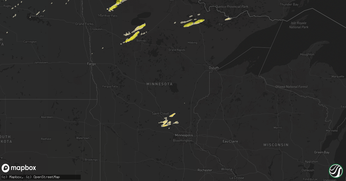
Hail Map in Minnesota on September 12, 2018
Get this storm
September 12 map
$229
one time, instant access
Download today. No call, no setup
Keep the $229
Bought the map and want the full workflow? Apply the entire $229 to a subscription within 7 days. None of it is wasted.
Every map, not just this one
This buys you this map. Subscription and you get every map we run, in the markets you choose from a few cities to whole states to nationwide. Plus real-time alerts the moment a storm fires.
Contact data
Name, contact info, occupancy, even credit band for addresses in the footprint. You go from where it hit to who to call.
Become the source they trust
Unlimited branding weather history reports on demand. You already have the documented answer ready for the property owner, and you are the one who showed up with it.
Property data and RoofTrace estimates
Pull up any address you have got, its value and the exact code rules for that jurisdiction, straight from One Click Code. Then RoofTrace estimates the squares, pitch, and roof value, priced the way you price.
Storm reports in Minnesota
Minnesota
| Date | Description |
|---|---|
| 09/12/20184:35 PM CDT | Mostly dime to nickel size. |
| 09/12/20183:57 PM CDT | Time estimated from radar. |
| 09/12/20183:30 PM CDT | Corrects previous hail report from 2 e celina. Spotter estimated half-dollar size then measured 1 inch diameter. Hail covered the ground. |
| 09/12/20183:12 PM CDT | Mostly half inch size with some larger stones...including a few quarters. |
| 09/12/20182:53 PM CDT | Mostly nickel size hail with a few quarters. Time estimated from radar. |
| 09/12/20182:07 PM CDT | A local report indicates 1.25 inch wind near SHEVLIN |
| 09/12/20182:02 PM CDT | Report of quarter sized hail relayed through local media. Time estimated on radar. |
| 09/12/20181:56 PM CDT | Report of quarter sized hail relayed through local media. Time estimated on radar. |
| 09/12/20187:45 AM CDT | At 1245 PM CDT, a severe thunderstorm was located near Twin Valley, or 33 miles northeast of Fargo, moving northeast at 55 mph. HAZARD...Half dollar size hail. SOURCE...Radar indicated. IMPACT...Damage to vehicles is expected. This severe thunderstorm will be near... Twin Valley around 1250 PM CDT. Gary around 1255 PM CDT. Waukon and Faith around 100 PM CDT. Ranum and Mahnomen around 105 PM CDT. Bejou around 110 PM CDT. |
| 09/12/201812:46 AM CDT | At 545 PM CDT, a severe thunderstorm was located over southwestern Boundary Waters Canoe Area Wilderness, or 19 miles northeast of Ely, moving east at 40 mph. HAZARD...Quarter size hail. SOURCE...Radar indicated. IMPACT...Damage to vehicles is expected. Locations impacted include... Boundary Waters Canoe Area Wilderness, Sea Gull Lake, Little Saganaga Lake, Alpine Lake, Snowbank Lake, Basswood Lake, Saganaga Lake, Ensign Lake, Kekekabic Lake, Thomas Lake, Knife Lake, Ojibway Lake, Disappointment Lake, and Gabimichigami Lake. |
| 09/11/201811:30 PM CDT | At 429 PM CDT, a severe thunderstorm was located over Williams, or 37 miles east of Roseau, moving northeast at 35 mph. HAZARD...60 mph wind gusts and quarter size hail. SOURCE...Radar indicated. IMPACT...Hail damage to vehicles is expected. Expect wind damage to roofs, siding, and trees. This severe thunderstorm will be near... Graceton around 435 PM CDT. Zippel Bay State Park and Pitt around 445 PM CDT. Wheelers Point around 450 PM CDT. |
| 09/11/201811:11 PM CDT | At 411 PM CDT, a severe thunderstorm was located 8 miles southeast of Buyck, or 10 miles north of Lake Vermili |
| 09/11/201811:01 PM CDT | At 401 PM CDT, a severe thunderstorm was located 10 miles southwest of Nett Lake, or 38 miles west of Lake Vermilion, moving east at 40 mph. HAZARD...60 mph wind gusts and quarter size hail. SOURCE...Radar indicated. IMPACT...Hail damage to vehicles is expected. Expect wind damage to roofs, siding, and trees. Locations impacted include... Nett Lake, Orr, Gheen, Pelican Lake, Cusson, Bois Forte Reservation, and Greaney. |
| 09/11/201810:58 PM CDT | At 357 PM CDT, a severe thunderstorm was located 9 miles east of Gheen, or 12 miles northwest of Lake Vermilion, moving east at 45 mph. This storm has produced quarter size hail. HAZARD...60 mph wind gusts. SOURCE...Trained weather spotters. IMPACT...Expect damage to roofs, siding, and trees. Locations impacted include... Lake Vermilion, Cummings Lake, Trout Lake, Big Moose Lake, and Loon Lake. |
| 09/11/201810:42 PM CDT | At 341 PM CDT, a severe thunderstorm was located near Gheen, or 21 miles west of Lake Vermilion, moving northeast at 40 mph. This storm has produced hail the size of quarters. HAZARD...60 mph wind gusts and quarter size hail. SOURCE...Trained weather spotters. IMPACT...Hail damage to vehicles is expected. Expect wind damage to roofs, siding, and trees. Locations impacted include... Lake Vermilion, Orr, Meadow Brook, Gheen, Buyck, Pelican Lake, Linden Grove, Greaney, and Trout Lake. |
| 09/11/201810:23 PM CDT | At 322 PM CDT, a severe thunderstorm was located near Togo, or 33 miles west of Lake Vermilion, moving northeast at 40 mph. HAZARD...60 mph wind gusts and quarter size hail. SOURCE...Radar indicated. IMPACT...Hail damage to vehicles is expected. Expect wind damage to roofs, siding, and trees. Locations impacted include... Cook, Orr, Meadow Brook, Gheen, Togo, Pelican Lake, Linden Grove, Celina, Greaney, and Bois Forte Reservation. |
| 09/11/20189:50 PM CDT | At 250 PM CDT, a severe thunderstorm was located over Island Lake in Beltrami County, or 21 miles north of Bemidji, moving northeast at 35 mph. HAZARD...60 mph wind gusts and quarter size hail. SOURCE...Radar indicated. IMPACT...Hail damage to vehicles is expected. Expect wind damage to roofs, siding, and trees. This severe thunderstorm will be near... Nebish around 300 PM CDT. Redby around 305 PM CDT. Saum around 325 PM CDT. Shotley around 335 PM CDT. Kelliher around 340 PM CDT. |
| 09/11/20189:30 PM CDT | At 230 PM CDT, severe thunderstorms were located along a line extending from near Holt to near Espelie, moving north at 30 mph. HAZARD...60 mph wind gusts and half dollar size hail. SOURCE...Radar indicated. IMPACT...Hail damage to vehicles is expected. Expect wind damage to roofs, siding, and trees. Severe thunderstorms will be near... Espelie around 235 PM CDT. Middle River and Grygla around 245 PM CDT. Carmel around 250 PM CDT. Strathcona around 255 PM CDT. Gates Corner and Skime around 315 PM CDT. |
| 09/11/20188:58 PM CDT | At 158 PM CDT, a severe thunderstorm was located near Bagley, or 21 miles west of Bemidji, moving northeast at 40 mph. HAZARD...Quarter size hail. SOURCE...Radar indicated. IMPACT...Damage to vehicles is expected. This severe thunderstorm will be near... Shevlin around 205 PM CDT. Solway and Pinewood around 215 PM CDT. Wilton around 220 PM CDT. Bemidji around 225 PM CDT. Puposky and Lake Bemidji State Park around 235 PM CDT. |
All States Impacted by Hail Map on September 12, 2018
Cities Impacted by Hail Map on September 12, 2018
- Orr, MN
- Grygla, MN
- Monticello, MN
- Anoka, MN
- Elk River, MN
- Drake, ND
- Middle River, MN
- Newfolden, MN
- Gatzke, MN
- Souris, ND
- Des Lacs, ND
- Burlington, ND
- Underwood, ND
- Zap, ND
- Hazen, ND
- Beulah, ND
- Stanton, ND
- South Haven, MN
- Big Lake, MN
- Roosevelt, MN
- Shevlin, MN
- Richardton, ND
- Halliday, ND
- Taylor, ND
- Clearbrook, MN
- Bagley, MN
- Leonard, MN
- Parrish, FL
- Tampa, FL
- Ryder, ND
- Redby, MN
- Puposky, MN
- Redlake, MN
- Blackduck, MN
- Osnabrock, ND
- Zimmerman, MN
- Georgetown, MN
- Clearwater, MN
- Annandale, MN
- Maple Lake, MN
- Newburg, ND
- Westhope, ND
- Maxbass, ND
- Douglas, ND
- Towner, ND
- Dunseith, ND
- Willow City, ND
- Knox, ND
- York, ND
- Thief River Falls, MN
- Solway, MN
- Bemidji, MN
- Cook, MN
- Esmond, ND
- Roseau, MN
- Glen Ullin, ND
- Mott, ND
- New Leipzig, ND
- Gladstone, ND
- Wannaska, MN
- Williams, MN
- Minot, ND
- Deering, ND
- Norwich, ND
- Surrey, ND
- Fairdale, ND
- Oberon, ND
- Becker, MN
- Princeton, MN
- Harvey, ND
- Lengby, MN
- Buffalo, MN
- Palmetto, FL
- Wimauma, FL
- Apollo Beach, FL
- Ruskin, FL
- Kelliher, MN
- Warroad, MN
- Ada, MN
- Two Dot, MT
- Clear Lake, MN
- Max, ND
- Alsen, ND
- Langdon, ND
- Salol, MN
- Park River, ND
- Devils Lake, ND
- Crary, ND
- Tenstrike, MN
- Bradenton, FL
- Bathgate, ND
- Hoople, ND
- New Salem, ND
- Bisbee, ND
- Cavalier, ND
- Hines, MN
- Dickinson, ND
- Big Falls, MN
- Mahnomen, MN
- Rugby, ND
- Golden Valley, ND
- Mora, MN
- Stephen, MN
- Voltaire, ND


