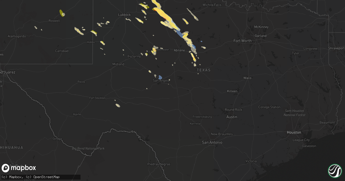
Hail Map in Texas on September 11, 2023
Get this storm
September 11 map
$229
one time, instant access
Download today. No call, no setup
Keep the $229
Bought the map and want the full workflow? Apply the entire $229 to a subscription within 7 days. None of it is wasted.
Every map, not just this one
This buys you this map. Subscription and you get every map we run, in the markets you choose from a few cities to whole states to nationwide. Plus real-time alerts the moment a storm fires.
Contact data
Name, contact info, occupancy, even credit band for addresses in the footprint. You go from where it hit to who to call.
Become the source they trust
Unlimited branding weather history reports on demand. You already have the documented answer ready for the property owner, and you are the one who showed up with it.
Property data and RoofTrace estimates
Pull up any address you have got, its value and the exact code rules for that jurisdiction, straight from One Click Code. Then RoofTrace estimates the squares, pitch, and roof value, priced the way you price.
Storm reports in Texas
Texas
| Date | Description |
|---|---|
| 09/11/20236:30 PM CDT | A local report indicates 60 MPH wind near Rule |
| 09/11/20235:29 PM CDT | A local report indicates 64 MPH wind near 10 WSW Guthrie |
| 09/10/202311:48 PM CDT | Power pole reported down in the area due to thunderstorm winds. |
| 09/10/202311:15 PM CDT | Fence blown down... Rv shifted due to strong winds. |
| 09/10/202311:00 PM CDT | Several power poles snapped along hwy 87. Time is estimated by radar. |
| 09/10/202310:48 PM CDT | Corrects previous tstm wnd dmg report from 5 nnw san angelo. Power pole reported down in the area due to thunderstorm winds. |
| 09/10/20239:45 PM CDT | Mesonet station fw9693 pyote. |
| 09/10/20239:45 PM CDT | A local report indicates 1.75 inch wind near Cross Plains |
| 09/10/20239:41 PM CDT | A local report indicates 1.00 inch wind near Cross Plains |
| 09/10/20239:29 PM CDT | Asos station kink wink. |
| 09/10/20239:25 PM CDT | A local report indicates 1.50 inch wind near 5 SW Atwell |
| 09/10/20238:49 PM CDT | Mesonet stati |
| 09/10/20238:49 PM CDT | Mesonet station 77 1sse lomax lomax/howard county. |
| 09/10/20238:41 PM CDT | Kbkd 30030g54kt. |
| 09/10/20238:14 PM CDT | Report from mping: quarter |
| 09/10/20238:05 PM CDT | Portions of westbound i-20 closed due to multiple blown over tractor trailers/semi trucks. |
| 09/10/20237:52 PM CDT | *** 3 inj *** tractor trailer blown over along i-20. Video shared via email. |
| 09/10/20237:50 PM CDT | On fm 644... Broken windows from hail and wind. |
All States Impacted by Hail Map on September 11, 2023
Cities Impacted by Hail Map on September 11, 2023
- Dagsboro, DE
- Jacksonville, FL
- Matador, TX
- Corona, NM
- Dickens, TX
- Afton, TX
- Floydada, TX
- Mcadoo, TX
- Saint Augustine, FL
- Elkton, FL
- Paducah, TX
- Aspermont, TX
- Roswell, NM
- Old Glory, TX
- Deland, FL
- Eustis, FL
- Pierson, FL
- Orange City, FL
- Rochester, TX
- O'Brien, TX
- Rule, TX
- Post, TX
- Ralls, TX
- Haskell, TX
- Crosbyton, TX
- Vaughn, NM
- Green Cove Springs, FL
- Paisley, FL
- Lockney, TX
- Silverton, TX
- Palatka, FL
- Encino, NM
- Blackshear, GA
- Flomot, TX
- Florahome, FL
- Interlachen, FL
- Conchas Dam, NM
- Hilliard, FL
- Plains, TX
- Pomona Park, FL
- Satsuma, FL
- Welaka, FL
- Goose Creek, SC
- Saint George, SC
- Waycross, GA
- Archer, FL
- Ocala, FL
- Dunnellon, FL
- Morriston, FL
- Dorchester, SC
- Savannah, GA
- Bryceville, FL
- Wadley, GA
- Midville, GA
- Lake Butler, FL
- Lake City, FL
- Alachua, FL
- Fort Stewart, GA
- Walker, MN
- Hawthorne, FL
- Micanopy, FL
- Quitaque, TX
- Salem, SC
- Stamford, TX
- Lueders, TX
- Avoca, TX
- Albany, TX
- Justiceburg, TX
- Lovington, NM
- Denver City, TX
- Maitland, FL
- Orlando, FL
- Winter Park, FL
- Loraine, TX
- Roscoe, TX
- Colorado City, TX
- Westbrook, TX
- Trent, TX
- Tye, TX
- Sweetwater, TX
- Abilene, TX
- Clyde, TX
- Merkel, TX
- Moran, TX
- Seminole, TX
- Breckenridge, TX
- Cross Plains, TX
- Baird, TX
- Cisco, TX
- San Angelo, TX
- Meadow, TX
- Seville, FL
- Crescent City, FL
- Andrews, TX
- Wrens, GA
- Stapleton, GA
- Maryneal, TX
- Gibson, GA
- Avera, GA
- Slaton, TX
- Lorenzo, TX
- Paint Rock, TX
- Mereta, TX
- Mayhill, NM
- Coahoma, TX
- Whiteface, TX
- Snyder, TX
- Walterboro, SC
- Green Pond, SC
- Hermleigh, TX
- Tinnie, NM
- Spur, TX
- Throckmorton, TX
- Weinert, TX
- Munday, TX
- Goree, TX
- Georgetown, FL
- Debary, FL
- Seymour, TX
- Stanton, TX
- Fort McCoy, FL
- Fort Myers, FL
- Apopka, FL
- San Mateo, FL
- Lubbock, TX
- Charleston, SC
- Lenorah, TX
- Winter Garden, FL
- Clermont, FL
- Tavares, FL
- Vancourt, TX
- Swainsboro, GA
- Brownwood, TX
- May, TX
- Rising Star, TX
- Winters, TX
- Sterling City, TX
- Burkett, TX
- Hinesville, GA
- Fargo, GA
- Carlsbad, TX
- Eastland, TX
- Ranger, TX
- Dryden, TX
- Mertzon, TX
- Mingus, TX
- Fort Stockton, TX


