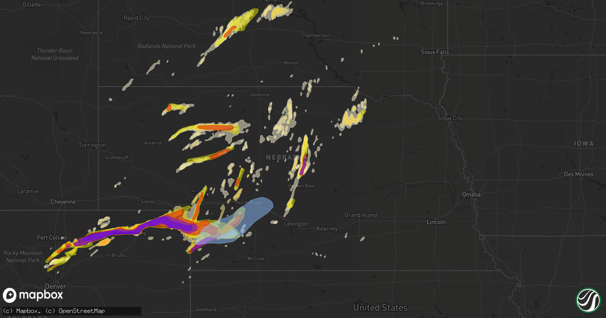
Hail Map in Nebraska on September 11, 2019
Get this storm
September 11 map
$229
one time, instant access
Download today. No call, no setup
Keep the $229
Bought the map and want the full workflow? Apply the entire $229 to a subscription within 7 days. None of it is wasted.
Every map, not just this one
This buys you this map. Subscription and you get every map we run, in the markets you choose from a few cities to whole states to nationwide. Plus real-time alerts the moment a storm fires.
Contact data
Name, contact info, occupancy, even credit band for addresses in the footprint. You go from where it hit to who to call.
Become the source they trust
Unlimited branding weather history reports on demand. You already have the documented answer ready for the property owner, and you are the one who showed up with it.
Property data and RoofTrace estimates
Pull up any address you have got, its value and the exact code rules for that jurisdiction, straight from One Click Code. Then RoofTrace estimates the squares, pitch, and roof value, priced the way you price.
Storm reports in Nebraska
Nebraska
| Date | Description |
|---|---|
| 09/11/20196:59 PM CDT | Quarter size hail observed |
| 09/11/20196:54 PM CDT | A local report indicates 1.00 inch wind near 25 NNW WHITMAN |
| 09/11/20196:51 PM CDT | Estimated between nickel and quarter size |
| 09/11/20196:51 PM CDT | A local report indicates 1.75 inch wind near 7 W CHAMPION |
| 09/11/20196:51 PM CDT | A local report indicates 1.00 inch wind near 1 W TRYON |
| 09/11/20196:30 PM CDT | Report via social media from storm last night of wind damage. Damage to house... Roof... Siding. Damage to crops. |
| 09/11/20196:25 PM CDT | Hail was flat in shape. |
| 09/11/20196:15 PM CDT | Time of hail was estimated between 6pm and 630pm. Report via social media. |
| 09/11/20195:45 PM CDT | Estimated nickel to quarter size |
| 09/11/20195:14 PM CDT | A local report indicates 1.00 inch wind near RUSHVILLE |
| 09/11/20196:44 AM CDT | At 1144 PM CDT, severe thunderstorms were located along a line extending from 6 miles south of Oconto to 6 miles west of Lexington to near Elwood to near Holbrook, moving east at 30 mph. HAZARD...60 mph wind gusts. SOURCE...Radar indicated. IMPACT...Expect damage to roofs, siding, and trees. Locations impacted include... Lexington, Holdrege, Cozad, Elm Creek, Bertrand, Elwood, Overton, Odessa, Loomis, Amherst, Sumner, Funk, Miller, Atlanta, Eddyville, Smithfield, Willow Island and Johnson Lake.This includes Interstate 80 between mile markers 217 and 268. |
| 09/11/20196:32 AM CDT | At 1131 PM CDT, severe thunderstorms were located along a line extending from 9 miles south of Callaway to 9 miles northeast of Cozad to near Johnson Lake to near Medicine Creek Reservoir State Recreation Area, moving east at 35 mph. HAZARD...70 mph wind gusts and penny size hail. SOURCE...Radar indicated. IMPACT...Expect considerable tree damage. Damage is likely to mobile homes, roofs, and outbuildings. Locations impacted include... Eustis, Mason City, Oconto, Medicine Creek Reservoir State Recreation Area, Buckeye, Block Hill Basin, Pressey State Wildlife Management Area, Burr Oak, Gavin Siding, Lodi, Intersection of Highway 183 and Cumro Road and Cumro.This includes the following highways... Highway 183 between mile markers 73 and 87. Highway 2 between mile markers 297 and 307. Highway 92 near mile marker 308. |
| 09/11/20196:05 AM CDT | At 1105 PM CDT, severe thunderstorms were located along a line extending from near Dunning to 11 miles southwest of Callaway, moving east at 45 mph. HAZARD...60 mph wind gusts and quarter size hail. SOURCE...Radar indicated. IMPACT...Hail damage to vehicles is expected. Expect wind damage to roofs, siding, and trees. Locations impacted include... Broken Bow, Taylor, Callaway, Sargent, Ansley, Merna, Mason City, Anselmo, Comstock, Berwyn, Victoria Springs State Recreation Area, Weissert, Westerville, Lillian, Milburn, Milburn Diversion Dam State Wildlife Management Area, Walworth, Lodi, Kent Diversion Dam State Wildlife Management Area and Finchville.This includes the following highways... Highway 183 between mile markers 85 and 129. Highway 2 between mile markers 239 and 303. Highway 92 between mile markers 251 and 307. |
| 09/11/20195:46 AM CDT | At 1046 PM CDT, severe thunderstorms were located along a line extending from 12 miles northeast of Maxwell to near Moorefield to 10 miles northeast of Culbertson, moving east at 50 mph. HAZARD...60 mph wind gusts. SOURCE...Radar indicated. IMPACT...Expect damage to roofs, siding, and trees. Locations impacted include... Lexington, Cozad, Gothenburg, Elwood, Sumner, Eddyville, Smithfield, Willow Island, Johnson Lake and Farnam.This includes Interstate 80 between mile markers 209 and 244. |
| 09/11/20195:36 AM CDT | At 1036 PM CDT, severe thunderstorms were located along a line extending from near North Platte Airport to 8 miles south of Maxwell to near Curtis to 11 miles north of Culbertson, moving east at 55 mph. HAZARD...70 mph wind gusts and penny size hail. SOURCE...Radar indicated. IMPACT...Expect considerable tree damage. Damage is likely to mobile homes, roofs, and outbuildings. Locations impacted include... North Platte, Curtis, Brady, Eustis, Maxwell, Oconto, Moorefield, Stockville, Lake Maloney State Recreation Area, Medicine Creek Reservoir State Recreation Area, North Platte Airport, Keith, Maywood, Cottonwood Canyon State Wildlife Management Area, Willow View Campground, Freedom, Buckeye, Orafino, Vroman and Red Willow Reservoir State Recreation Area.This includes the following highways... Interstate 80 in Nebraska between mile markers 176 and 207. Highway 83 between mile markers 27 and 55, and between mile markers76 and 85. |
| 09/11/20194:41 AM CDT | At 941 PM CDT/841 PM MDT/, severe thunderstorms were located along a line extending from 8 miles southwest of Paxton to near Elsie to near Wauneta, moving east at 55 mph. HAZARD...70 mph wind gusts and quarter size hail. SOURCE...Radar indicated. IMPACT...Hail damage to vehicles is expected. Expect considerable tree damage. Wind damage is also likely to mobile homes, roofs, and outbuildings. Locations impacted include... Curtis, Hayes Center, Wauneta, Wallace, Maxwell, Madrid, Elsie, Wellfleet, Moorefield, Stockville, Dickens, Lake Maloney State Recreation Area, Enders Reservoir State Recreation Area, Enders, Keith, Maywood, Hamlet, Cottonwood Canyon State Wildlife Management Area, Center Dam Campground and Willow View Campground.This includes the following highways... Highway 61 between mile markers 26 and 30. Interstate 80 in Nebraska between mile markers 181 and 197. Highway 83 between mile markers 27 and 80. |
| 09/11/20193:55 AM CDT | At 855 PM CDT, a severe thunderstorm was located near Dickens, or 22 miles southwest of North Platte, moving northeast at 25 mph. HAZARD...Two inch hail and 60 mph wind gusts. SOURCE...Radar indicated. IMPACT...People and animals outdoors will be injured. Expect hail damage to roofs, siding, windows, and vehicles. Expect wind damage to roofs, siding, and trees. Locations impacted include... North Platte, Hershey, Wallace, Maxwell, Dickens, Lake Maloney State Recreation Area, North Platte Airport, Keith, Cottonwood Canyon State Wildlife Management Area, Birdwood and Somerset.This includes the following highways... Highway 97 between mile markers 1 and 2. Interstate 80 in Nebraska between mile markers 161 and 195. Highway 83 between mile markers 65 and 87. |
| 09/11/20193:41 AM CDT | At 841 PM CDT, a severe thunderstorm was located 10 miles northeast of Page, or 18 miles east of O'Neill, moving northeast at 20 mph. HAZARD...60 mph wind gusts and half dollar size hail. SOURCE...Radar indicated. IMPACT...Hail damage to vehicles is expected. Expect wind damage to roofs, siding, and trees. This severe thunderstorm will remain over mainly rural areas of southwestern Knox County. |
| 09/11/20193:33 AM CDT | At 833 PM CDT, a severe thunderstorm was located 9 miles north of Page, or 14 miles east of O'Neill, moving northeast at 20 mph. HAZARD...60 mph wind gusts and quarter size hail. SOURCE...Radar indicated. IMPACT...Hail damage to vehicles is expected. Expect wind damage to roofs, siding, and trees. This severe thunderstorm will remain over mainly rural areas of east central Holt County. |
| 09/11/20193:13 AM CDT | At 813 PM CDT/713 PM MDT/, a severe thunderstorm was located 10 miles southwest of Wallace, or 18 miles northwest of Hayes Center, moving northeast at 20 mph. HAZARD...Golf ball size hail. SOURCE...Radar indicated. IMPACT...People and animals outdoors will be injured. Expect damage to roofs, siding, windows, and vehicles. Locations impacted include... Wallace, Wellfleet, Dickens, Grainton and Somerset. This includes Highway 83 between mile markers 57 and 60. |
| 09/11/20192:48 AM CDT | At 747 PM MDT, severe thunderstorms were located along a line extending from 3 miles north of Sedgwick to near Amherst, or along a line extending from 8 miles southwest of Chappell to 6 miles northeast of Holyoke, moving east at 55 mph. These are very dangerous storms. HAZARD...Baseball size hail and 70 mph wind gusts. SOURCE...Trained weather spotters. IMPACT...People and animals outdoors will be severely injured. Expect shattered windows, extensive damage to roofs, siding, and vehicles. Locations impacted include... Holyoke, Julesburg, Ovid, Sedgwick, Paoli, Amherst, Twin Buttes, Pleasant Valley, Fairfield, Marks Butte and Sixteen-Mile Corner. |
| 09/11/20192:32 AM CDT | At 731 PM CDT/631 PM MDT/, a severe thunderstorm was located 11 miles northeast of Imperial, moving northeast at 35 mph. HAZARD...Golf ball size hail. SOURCE...Radar indicated. IMPACT...People and animals outdoors will be injured. Expect damage to roofs, siding, windows, and vehicles. Locations impacted include... Wallace, Madrid, Elsie, Dickens and Grainton. This includes Highway 61 between mile markers 46 and 54. |
| 09/11/20192:11 AM CDT | At 711 PM MDT, severe thunderstorms were located along a line extending from 6 miles northeast of Westplains to near St Petersburg, or along a line extending from 23 miles southeast of Kimball to 21 miles east of Sterling, moving east at 65 mph. These are very dangerous storms. HAZARD...Baseball size hail and 60 mph wind gusts. SOURCE...Trained weather spotters. IMPACT...People and animals outdoors will be severely injured. Expect shattered windows, extensive damage to roofs, siding, and vehicles. Locations impacted include... Holyoke, Haxtun, Fleming, Iliff, Peetz, Sedgwick, Crook, Paoli, St Petersburg, Proctor, Padroni, Pleasant Valley, North Sterling Reservoir, Marks Butte, Amherst, Highland Center, Westplains, Twin Buttes and Fairfield. |
| 09/11/20192:01 AM CDT | At 700 PM MDT, severe thunderstorms were located along a line extending from 9 miles northwest of Westplains to 9 miles southeast of Sterling, or along a line extending from 21 miles south of Kimball to 28 miles north of Akron, moving east at 65 mph. These are very dangerous storms. HAZARD...Baseball size hail and 60 mph wind gusts. SOURCE...Radar indicated. IMPACT...People and animals outdoors will be severely injured. Expect shattered windows, extensive damage to roofs, siding, and vehicles. Locations impacted include... Sterling, Holyoke, Haxtun, Fleming, Iliff, Peetz, Sedgwick, Crook, Paoli, St Petersburg, Proctor, Padroni, Atwood, Pleasant Valley, North Sterling Reservoir, Marks Butte, Amherst, Highland Center, Westplains and Twin Buttes. |
| 09/11/20191:50 AM CDT | At 650 PM CDT, a severe thunderstorm was located near Oconto, or 22 miles southwest of Broken Bow, moving north at 20 mph. HAZARD...Ping pong ball size hail and 60 mph wind gusts. SOURCE...Radar indicated. IMPACT...People and animals outdoors will be injured. Expect hail damage to roofs, siding, windows, and vehicles. Expect wind damage to roofs, siding, and trees. Locations impacted include... Oconto, Lodi and Pressey State Wildlife Management Area. |
| 09/11/20191:29 AM CDT | At 629 PM MDT, a severe thunderstorm was located over Brule, or 8 miles west of Ogallala, moving north at 35 mph. HAZARD...Golf ball size hail. SOURCE...Radar indicated. IMPACT...People and animals outdoors will be injured. Expect damage to roofs, siding, windows, and vehicles. Locations impacted include... Ogallala, Brule, Lemoyne, Kingsley Dam, Eagle Gulch Campground, Belmar, Megeath, Otter Creek Campground and Lake View Campground.This includes the following highways... Highway 61 between mile markers 85 and 109. Highway 92 between mile markers 122 and 138. Interstate 80 in Nebraska between mile markers 111 and 127. |
| 09/11/20191:28 AM CDT | At 628 PM CDT, a severe thunderstorm was located 14 miles north of Sutherland, or 15 miles southwest of Tryon, moving north at 30 mph. HAZARD...Half dollar size hail. SOURCE...Radar indicated. IMPACT...Damage to vehicles is expected. Locations impacted include... Tryon.This includes the following highways... Highway 92 between mile markers 192 and 210. Highway 97 between mile markers 16 and 18, and between mile markers21 and 41. |
| 09/11/20191:27 AM CDT | At 626 PM MDT, a severe thunderstorm was located 11 miles south of Whitman, or 23 miles north of Arthur, moving northeast at 35 mph. HAZARD...60 mph wind gusts and half dollar size hail. SOURCE...Radar indicated. IMPACT...Hail damage to vehicles is expected. Expect wind damage to roofs, siding, and trees. Locations impacted include... Mullen, Whitman, Carr Lake, Cogill Lake, Hecla and Weir. This includes the following highways... Highway 2 between mile markers 153 and 187. Highway 97 between mile markers 54 and 71. |
| 09/11/20191:20 AM CDT | At 620 PM CDT, a severe thunderstorm was located near Victoria Springs State Recreation Area, or 14 miles north of Broken Bow, moving north at 30 mph. HAZARD...Ping pong ball size hail and 60 mph wind gusts. SOURCE...Radar indicated. IMPACT...People and animals outdoors will be injured. Expect hail damage to roofs, siding, windows, and vehicles. Expect wind damage to roofs, siding, and trees. Locations impacted include... Victoria Springs State Recreation Area, Lillian, Milburn, Almeria Meadow State Wildlife Management Area, Walworth, Almeria and Gates. |
| 09/11/20191:17 AM CDT | At 617 PM MDT, a severe thunderstorm was located 20 miles north of Whitman, or 29 miles northwest of Mullen, moving east at 25 mph. HAZARD...70 mph wind gusts and half dollar size hail. SOURCE...Radar indicated. IMPACT...Hail damage to vehicles is expected. Expect considerable tree damage. Wind damage is also likely to mobile homes, roofs, and outbuildings. Locations impacted include... Highway 97 crossing the North Loup River, Marsh Flat, Speckel Meir Lake, Round Lake, Hire, Highway 97 crossing Big Creek and Sevenmile Hill.This includes Highway 97 between mile markers 77 and 93. |
| 09/11/201912:56 AM CDT | At 555 PM MDT, a severe thunderstorm was located near Champion, or 9 miles west of Imperial, moving northeast at 25 mph. HAZARD...Tennis ball size hail. SOURCE...Radar indicated. IMPACT...People and animals outdoors will be injured. Expect damage to roofs, siding, windows, and vehicles. Locations impacted include... Imperial, Champion, Crete, Chase and Wanamaker State Wildfire Management Area.This includes Highway 61 between mile markers 41 and 53. |
| 09/11/201912:53 AM CDT | At 553 PM MDT, a severe thunderstorm was located over Venango, or 15 miles west of Grant, moving northeast at 45 mph. HAZARD...Golf ball size hail. SOURCE...Radar indicated. IMPACT...People and animals outdoors will be injured. Expect damage to roofs, siding, windows, and vehicles. Locations impacted include... Grant, Brule, Venango, Brandon, Wild Horse Spring and Megeath. This includes the following highways... Highway 61 between mile markers 68 and 86. Interstate 80 in Nebraska between mile markers 109 and 125. |
| 09/11/201912:36 AM CDT | At 536 PM MDT, a severe thunderstorm was located 17 miles south of Ashby, or 24 miles northwest of Arthur, moving northeast at 35 mph. HAZARD...Ping pong ball size hail and 60 mph wind gusts. SOURCE...Radar indicated. IMPACT...People and animals outdoors will be injured. Expect hail damage to roofs, siding, windows, and vehicles. Expect wind damage to roofs, siding, and trees. Locations impacted include... Hyannis, Swede Lake, Pratt Lake, Spring Valley Lake and Duluth. This includes the following highways... Highway 2 between mile markers 139 and 156. Highway 61 between mile markers 139 and 166. |
| 09/11/201912:23 AM CDT | At 522 PM MDT, a severe thunderstorm was located 23 miles north of Ashby, or 33 miles southeast of Gordon, moving northeast at 30 mph. HAZARD...Ping pong ball size hail and 60 mph wind gusts. SOURCE...Radar indicated. IMPACT...People and animals outdoors will be injured. Expect hail damage to roofs, siding, windows, and vehicles. Expect wind damage to roofs, siding, and trees. Locations impacted include... Round Lake and Intersection of Highway 61 and Survey Valley Road. This includes Highway 61 between mile markers 180 and 199. |
| 09/11/201912:22 AM CDT | At 521 PM MDT, a severe thunderstorm was located 15 miles south of Lamar, or 19 miles southeast of Holyoke, moving northeast at 35 mph. HAZARD...Ping pong ball size hail. SOURCE...Radar indicated. IMPACT...People and animals outdoors will be injured. Expect damage to roofs, siding, windows, and vehicles. Locations impacted include... Lamar, Crete and Chase. This includes Highway 61 between mile markers 51 and 53. |
| 09/11/201912:19 AM CDT | A local report indicates 63 MPH wind near 2 NNW ORD |
| 09/10/201911:22 PM CDT | At 421 PM MDT, a severe thunderstorm was located 12 miles northwest of Ellsworth, or 23 miles east of Alliance, moving northeast at 35 mph. HAZARD...60 mph wind gusts and half dollar size hail. SOURCE...Radar indicated. IMPACT...Hail damage to vehicles is expected. Expect wind damage to roofs, siding, and trees. Locations impacted include... Snow Lake, Diamond Lake, Wolf Hill and Argo Hill. This includes Highway 250 between mile markers 3 and 24. |
| 09/10/201911:02 PM CDT | At 402 PM MDT, a severe thunderstorm was located over Rushville, moving northeast at 40 mph. HAZARD...Ping pong ball size hail and 60 mph wind gusts. SOURCE...Radar indicated. IMPACT...People and animals outdoors will be injured. Expect hail damage to roofs, siding, windows, and vehicles. Expect wind damage to roofs, siding, and trees. Locations impacted include... Gordon, Rushville, Hay Springs, White Clay, Clinton, Intersection of Highway 87 and Craven Creek Road, Lone Butte, Intersection of Beaver Creek Road and White Clay Creek Road, Intersection of Highway 87 and Larabee Road, Mount Maria, Highway 250 crossing the Niobrara River, Walgren Lake State Recreation Area, Pine Ridge, Hoover Lake, Metcalf State Wildlife Management Area and Intersection of Highway 87 and Antelope Road.This includes the following highways... Highway 20 between mile markers 77 and 106. Highway 250 between mile markers 37 and 48. |
| 09/10/201910:51 PM CDT | Asos station kmck mccook airport. |
| 09/10/201910:39 PM CDT | A local report indicates 72 MPH wind near 3 ENE NORTH PLATTE |
| 09/10/201910:34 PM CDT | Lots of tree limbs on the ground... Mostly small but a few possibly around 4 inches. |
| 09/10/201910:19 PM CDT | A local report indicates 58 MPH wind near 3 WNW TRENTON |
| 09/10/20199:59 PM CDT | A local report indicates 80 MPH wind near 7 W HAYES CENTER |
| 09/10/20199:57 PM CDT | Semi-truck and trailer flipped. Report passed on from em. |
| 09/10/20199:57 PM CDT | Report passed on from em |
| 09/10/20199:45 PM CDT | Two semi trailers blown over and a power pole downed. Time estimated from radar |
| 09/10/20199:45 PM CDT | Delayed report via social media. |
| 09/10/20199:29 PM CDT | A local report indicates 70 MPH wind near IMPERIAL |
| 09/10/20199:27 PM CDT | 60 mph wind gusts and nickel size hail |
| 09/10/20199:09 PM CDT | A local report indicates 1.75 inch wind near VENANGO |
| 09/10/20199:02 PM CDT | A local report indicates 1.00 inch wind near 5 N DICKENS |
| 09/10/20198:32 PM CDT | Estimated nickel to quarter |
| 09/10/20197:50 PM CDT | A local report indicates 58 MPH wind near 16 NE IMPERIAL |
| 09/10/20197:50 PM CDT | A local report indicates 1.00 inch wind near 16 NE IMPERIAL |
| 09/10/20197:37 PM CDT | Report from mping: golf ball |
| 09/10/20197:33 PM CDT | A local report indicates 1.00 inch wind near 1 NE BRULE |
| 09/10/20197:25 PM CDT | Report from mping: ping pong ball |
| 09/10/20197:19 PM CDT | A local report indicates 1.75 inch wind near IMPERIAL |
| 09/10/20197:17 PM CDT | Estimated nickel with a few quarter size hail |
| 09/10/20197:15 PM CDT | A local report indicates 1.75 inch wind near IMPERIAL |
| 09/10/20197:10 PM CDT | Delayed corrected report. Prema utility company reported 14 power poles down in northeast hyannis. Power outages in the area. Time is approximated. |
All States Impacted by Hail Map on September 11, 2019
Cities Impacted by Hail Map on September 11, 2019
- Burke, SD
- Belvidere, SD
- Ovid, CO
- Sedgwick, CO
- Berthoud, CO
- Ainsworth, NE
- Taylor, NE
- Bassett, NE
- New Raymer, CO
- Arapahoe, CO
- Haigler, NE
- Huntsville, AL
- Coatesville, PA
- Andrews, TX
- Greeley, CO
- Platteville, CO
- Johnstown, CO
- Mead, CO
- Longmont, CO
- Evans, CO
- Milliken, CO
- Lucerne, CO
- Oneill, NE
- Erie, MI
- Cedar Springs, MI
- Sand Lake, MI
- Casnovia, MI
- Kent City, MI
- Bailey, MI
- Grant, MI
- Conneautville, PA
- Gordon, NE
- Hay Springs, NE
- Rushville, NE
- Pep, TX
- Enochs, TX
- Weskan, KS
- Venango, PA
- Cambridge Springs, PA
- Saegertown, PA
- Gregory, SD
- Mills, NE
- Round Hill, VA
- Paris, VA
- Boyce, VA
- Upperville, VA
- Middleburg, VA
- Purcellville, VA
- Berryville, VA
- Bluemont, VA
- Champion, NE
- Callaway, NE
- Cozad, NE
- Oconto, NE
- Springview, NE
- Kersey, CO
- Cheyenne, WY
- Grover, CO
- Norcatur, KS
- Tryon, NE
- Wray, CO
- Elsie, NE
- Enders, NE
- Wallace, NE
- Dickens, NE
- Hayes Center, NE
- Wauneta, NE
- Imperial, NE
- La Salle, CO
- Brown City, MI
- Mears, MI
- Shelby, MI
- Stapleton, NE
- Oberlin, KS
- Woodbridge, VA
- Manassas, VA
- Merriman, NE
- Ashby, NE
- Amherst, CO
- Blanchard, MI
- Mount Pleasant, MI
- Vestaburg, MI
- Riverdale, MI
- Shepherd, MI
- Jackson, MI
- Port Clinton, OH
- Fort Lupton, CO
- Weldona, CO
- Fort Morgan, CO
- Hardwick, MN
- Spencer, SD
- Nenzel, NE
- Seminole, TX
- Sutherland, NE
- North Platte, NE
- Hershey, NE
- Holyoke, CO
- Haxtun, CO
- Julesburg, CO
- Venango, NE
- Burwell, NE
- Sargent, NE
- Roswell, NM
- New London, WI
- Crozet, VA
- Charlottesville, VA
- Fort Pierre, SD
- Iliff, CO
- Sterling, CO
- Anselmo, NE
- Broken Bow, NE
- Shepherd, TX
- Findley Lake, NY
- Erie, PA
- North East, PA
- Sherman, NY
- Ripley, NY
- Harrisburg, NE
- Orchard, CO
- Vivian, SD
- Apple River, IL
- Elizabeth, IL
- Stockton, IL
- Brighton, CO
- Apple Springs, TX
- Groveton, TX
- Fox Lake, WI
- Waupun, WI
- Wanblee, SD
- Murdo, SD
- Draper, SD
- Johnstown, NE
- Bingham, NE
- Burns, WY
- Louisa, VA
- Gordonsville, VA
- Keystone, NE
- Lovington, NM
- Mertztown, PA
- Macungie, PA
- Alburtis, PA
- Wallace, KS
- Winona, KS
- Readyville, TN
- Milton, TN
- Morton, TX
- Amherst, TX
- Bloomington, WI
- Lancaster, WI
- Cassville, WI
- Hunlock Creek, PA
- Nanticoke, PA
- Page, NE
- Emmet, NE
- Inman, NE
- Long Valley, SD
- Midland, SD
- Okaton, SD
- Chugwater, WY
- Ellsworth, NE
- Lamar, CO
- Wiley, CO
- Ortonville, MI
- Ithaca, MI
- Maywood, NE
- Naponee, NE
- Pine Ridge, SD
- Dyersville, IA
- Farley, IA
- Worthington, IA
- Harvest, AL
- Hyannis, NE
- Boulder, CO
- Oshkosh, NE
- Briggsdale, CO
- McClave, CO
- Sheridan Lake, CO
- Gill, CO
- Eaton, CO
- Sharon Springs, KS
- Bellevue, IA
- Chapman, KS
- Crook, CO
- Lemoyne, NE
- Brule, NE
- Big Springs, NE
- Madrid, NE
- Grant, NE
- Chappell, NE
- Stoneham, CO
- Arthur, NE
- Ogallala, NE
- Paxton, NE
- Merino, CO
- Greenville, MI
- Geneva, OH
- Ovid, MI
- Owosso, MI
- Flint, MI
- Grand Blanc, MI
- Hopkinton, IA
- Campbellsport, WI
- Herrick, SD
- Mullen, NE
- North Branch, MI
- Clifford, MI
- Marlette, MI
- Allen, SD
- Lennon, MI
- Flushing, MI
- Corunna, MI
- Lakeview, MI
- Six Lakes, MI
- Wood Lake, NE
- Avoca, MI
- Jeddo, MI
- Fort Gratiot, MI
- New Lothrop, MI
- Severance, CO
- Windsor, CO
- Harrison, NE
- Cary, IL
- Crystal Lake, IL
- Mchenry, IL
- Barrington, IL
- Wauconda, IL
- Mundelein, IL
- Island Lake, IL
- Lake Geneva, WI
- Moss Point, MS
- Brewster, NE
- Valentine, NE
- Robesonia, PA
- Bernville, PA
- Hickory Corners, MI
- Delton, MI
- Niwot, CO
- Thaxton, VA
- Colby, KS
- Sperryville, VA
- Etlan, VA
- Madison, VA
- Haywood, VA
- Reva, VA
- Sheridan, MI
- Crystal, MI
- Carson City, MI
- Elsmere, NE
- Goodrich, MI
- Whitman, NE
- Neenah, WI
- Appleton, WI
- Port Huron, MI
- Smiths Creek, MI
- North Street, MI
- Lafayette, CO
- Erie, CO
- Seneca, NE
- Meherrin, VA
- Middleton, MI
- Saint Johns, MI
- Perrinton, MI
- Fowler, MI
- Elsie, MI
- Hubbardston, MI
- Maple Rapids, MI
- Edmore, MI
- Waterford, PA
- Harborcreek, PA
- Fulda, MN
- Corinne, UT
- Glenmoore, PA
- Thorndale, PA
- Downingtown, PA
- Linden, VA
- Hume, VA
- Markham, VA
- Buchanan, VA
- Earlysville, VA
- Free Union, VA
- Elwell, MI
- Fremont, WI
- Hortonville, WI
- Merna, NE
- Leesport, PA
- Reading, PA
- Woodville, VA
- Green Bay, VA
- Victoria, VA
- Dumfries, VA
- Wayne, MI
- Canton, MI
- Harrold, SD
- Fenwick, MI
- Mount Carmel, PA
- Locust Gap, PA
- Kulpmont, PA
- Coal Township, PA
- Marion Heights, PA
- Elysburg, PA
- Cascade, IA
- Delhi, IA
- Verdigre, NE
- Kendall, WI
- Seabrook, TX
- Arvonia, VA
- Holly, MI
- Oxford, MI
- Metamora, MI
- Wellfleet, NE
- Flint Hill, VA
- Silverwood, MI
- Thedford, NE
- Kadoka, SD
- Alma, MI
- Gowen, MI
- Dexter, NM
- Vernon Hills, IL
- Lake Zurich, IL
- Libertyville, IL
- Lincolnshire, IL
- Lake Forest, IL
- Harrisville, PA
- Castleton, VA
- Boston, VA
- Galena, IL
- Niobrara, NE
- Lynch, NE
- New Canton, VA
- Palmyra, VA
- Bremo Bluff, VA
- Scottsville, VA
- Chambers, NE
- Paxinos, PA
- Mitchell, SD
- Wernersville, PA
- Northville, MI
- Plymouth, MI
- Eastpointe, MI
- Saint Clair Shores, MI
- Roseville, MI
- Knox, PA
- Emlenton, PA
- Ann Arbor, MI
- South Lyon, MI
- Presho, SD
- Lower Brule, SD
- Brookwood, AL
- Alma, NE
- Sumner, MI
- Chester, TX
- Corrigan, TX
- Wagner, SD
- Dallas, SD
- Palisade, NE
- Ravenna, MI
- Laingsburg, MI
- Coral, MI
- Stanton, MI
- Belding, MI
- Trufant, MI
- Howard City, MI
- Pierson, MI
- Sidney, MI
- Atkinson, NE
- Weyauwega, WI
- Highland Park, IL
- Teague, TX
- Bristolville, OH
- Tuscumbia, AL
- East Dubuque, IL
- Twin Lake, MI
- Newaygo, MI
- Montague, MI
- Whitehall, MI
- Muskegon, MI
- Holton, MI
- Fremont, MI
- Hanover, VA
- Rives Junction, MI
- Pleasant Lake, MI
- Remus, MI
- Roseland, VA
- Sweet Valley, PA
- Atwood, KS
- Triangle, VA
- Whitmore Lake, MI
- Stickney, SD
- Waukesha, WI
- Long Pine, NE
- Manchester, IA
- Lewellen, NE
- Mentone, TX
- Ada, MI
- Pierre, SD
- Smithville, TX
- Tecumseh, MI
- Hillsboro, WI
- Elroy, WI
- Edgemont, SD
- Oelrichs, SD
- Hasty, CO
- Farnam, NE
- Brady, NE
- Hayden, AL
- Mineral Point, WI
- Dodgeville, WI
- Wiggins, CO
- Pewaukee, WI
- Hartland, WI
- Amelia, NE
- Fleetwood, PA
- Dunning, NE
- West Farmington, OH
- Gilcrest, CO
- Pittsville, WI
- Vesper, WI
- Ypsilanti, MI
- South Rockwood, MI
- Carleton, MI
- Peetz, CO
- Ruckersville, VA
- Loveland, CO
- Washington, VA
- Bentonville, VA
- Center Line, MI
- Warren, MI
- Hesperia, MI
- White Cloud, MI
- Trenton, MI
- Flat Rock, MI
- Lynch Station, VA
- Swartz Creek, MI
- Vernon, MI
- Durand, MI
- Meadville, PA
- Guys Mills, PA
- Bell, FL
- Old Town, FL
- Epworth, IA
- Zwingle, IA
- Peosta, IA
- Bernard, IA
- Clifton, VA
- Nokesville, VA
- Wisconsin Rapids, WI
- Honey Brook, PA
- Saint Louis, MI
- Mayville, MI
- Afton, VA
- Adger, AL
- Kutztown, PA
- Hamburg, PA
- Lyon Station, PA
- Edgerton, MN
- Stuarts Draft, VA
- Staunton, VA
- Republican City, NE
- Maybee, MI
- Willis, MI
- New Boston, MI
- Belleville, MI
- Front Royal, VA
- Delaplane, VA
- Sudan, TX
- Bancroft, MI
- Byron, MI
- Crossroads, NM
- Randolph, WI
- Cody, NE
- Middlefield, OH
- Glenvil, NE
- Hastings, NE
- Parks, NE
- Coolspring, PA
- Brookville, PA
- Farmville, VA
- Colome, SD
- Amissville, VA
- Waupaca, WI
- Big Rapids, MI
- Marshfield, WI
- Mohrsville, PA
- Monroe, MI
- Gates Mills, OH
- Beachwood, OH
- Cleveland, OH
- Adrian, MN
- Mission, SD
- Henderson, MI
- Oakley, MI
- Maple, TX
- Almont, MI
- Allenton, MI
- Platte, SD
- Ionia, MI
- Shiocton, WI
- Goodells, MI
- Munith, MI
- Larsen, WI
- La Motte, IA
- Slayton, MN
- Salem, OH
- Kenesaw, NE
- Fairbank, IA
- Readlyn, IA
- Greenwood, VA
- Manderson, SD
- Mukwonago, WI
- Avoca, MN
- Iona, MN
- Kingston, MI
- Fleming, CO
- Luverne, MN
- Fontana, WI
- Monticello, IN
- White River, SD
- Pottstown, PA
- Elverson, PA
- Huntly, VA
- Temple, PA
- Oley, PA
- Spring City, PA
- Chester Springs, PA
- West Chester, PA
- Monument, KS
- Edinboro, PA
- Maxwell, NE
- Gothenburg, NE
- Marne, MI
- Allendale, MI
- Wyoming, MI
- Grand Rapids, MI
- Lowell, MI
- Coopersville, MI
- North Bloomfield, OH
- Kinsman, OH
- Farmdale, OH
- Burghill, OH
- Harmony, PA
- Fombell, PA
- Cranberry Township, PA
- Rochester, PA
- New Brighton, PA
- Zelienople, PA
- Saxonburg, PA
- Evans City, PA
- Renfrew, PA
- Butler, PA
- Valencia, PA
- Parker, PA
- Galeton, CO
- Frederick, CO
- Dacono, CO
- Firestone, CO
- Louisville, CO
- Ashley, MI


