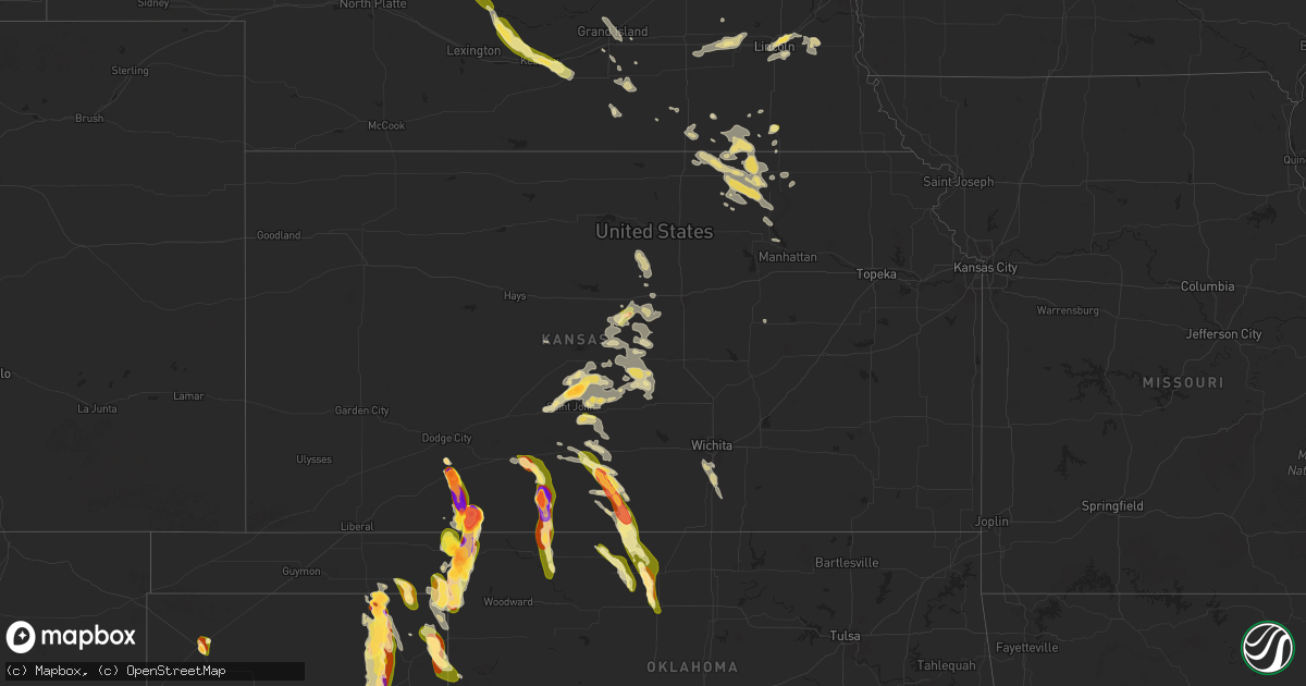
Hail Map in Kansas on September 8, 2025
Get this storm
September 8 map
$229
one time, instant access
Download today. No call, no setup
Keep the $229
Bought the map and want the full workflow? Apply the entire $229 to a subscription within 7 days. None of it is wasted.
Every map, not just this one
This buys you this map. Subscription and you get every map we run, in the markets you choose from a few cities to whole states to nationwide. Plus real-time alerts the moment a storm fires.
Contact data
Name, contact info, occupancy, even credit band for addresses in the footprint. You go from where it hit to who to call.
Become the source they trust
Unlimited branding weather history reports on demand. You already have the documented answer ready for the property owner, and you are the one who showed up with it.
Property data and RoofTrace estimates
Pull up any address you have got, its value and the exact code rules for that jurisdiction, straight from One Click Code. Then RoofTrace estimates the squares, pitch, and roof value, priced the way you price.
Storm reports in Kansas
Kansas
| Date | Description |
|---|---|
| 09/08/20256:45 PM CDT | A local report indicates 1.00 inch wind near Minneola |
| 09/08/20256:43 PM CDT | A local report indicates 3.00 inch wind near Minneola |
| 09/08/20256:43 PM CDT | Report was from social media with pictures. |
| 09/08/20256:42 PM CDT | A local report indicates 1.00 inch wind near 8 S Minneola |
| 09/08/20256:33 PM CDT | A local report indicates 2.75 inch wind near 9 ESE Wilmore |
| 09/08/20255:15 PM CDT | Measured 3.5 inches. |
| 09/08/20255:15 PM CDT | Measured about 3.5 inches. |
| 09/08/20255:09 PM CDT | A local report indicates 1.00 inch wind near Ashland |
| 09/08/20255:00 PM CDT | A local report indicates 3.00 inch wind near Ashland |
| 09/08/20254:41 PM CDT | A local report indicates 1.00 inch wind near Greensburg |
| 09/08/20251:45 PM CDT | A local report indicates 1.00 inch wind near 2 NNW Neola |
| 09/08/20259:45 AM CDT | A local report indicates 1.75 inch wind near 4 N Hudson |
| 09/08/20259:45 AM CDT | A local report indicates 1.75 inch wind near Hudson |
| 09/08/20259:31 AM CDT | A local report indicates 1.25 inch wind near 6 N Saint John |
| 09/08/20257:20 AM CDT | A local report indicates 1.00 inch wind near Ellsworth |
| 09/07/20257:08 PM CDT | A local report indicates 2.00 inch wind near 8 WSW Clark State Lake |
All States Impacted by Hail Map on September 8, 2025
Cities Impacted by Hail Map on September 8, 2025
- Brookville, KS
- Ellsworth, KS
- Kanopolis, KS
- Rosston, OK
- Follett, TX
- Lincoln, KS
- Higgins, TX
- Beverly, KS
- Belpre, KS
- Macksville, KS
- Hudson, KS
- Ellinwood, KS
- St John, KS
- Larned, KS
- Bushton, KS
- Great Bend, KS
- Geneseo, KS
- Lorraine, KS
- Holyrood, KS
- Lyons, KS
- Durham, OK
- Stafford, KS
- Sylvia, KS
- Beloit, KS
- Barnard, KS
- Pratt, KS
- Plevna, KS
- Sterling, KS
- Abbyville, KS
- Isabel, KS
- Nickerson, KS
- Sawyer, KS
- Chase, KS
- Olmitz, KS
- Raymond, KS
- Little River, KS
- Marquette, KS
- Alden, KS
- Hines, MN
- Turon, KS
- Blackduck, MN
- Northome, MN
- Cunningham, KS
- Hutchinson, KS
- Nashville, KS
- Inman, KS
- Zenda, KS
- Spivey, KS
- Attica, KS
- Medicine Lodge, KS
- Ashland, KS
- Haviland, KS
- Sharon, KS
- Hazelton, KS
- Mullinville, KS
- Greensburg, KS
- Burlington, OK
- Alva, OK
- Cherokee, OK
- Waldron, KS
- Dalhart, TX
- Valentine, NE
- Buffalo, OK
- Balko, OK
- Anthony, KS
- Sun City, KS
- Antelope, OR
- Mission, SD
- Selfridge, ND
- Englewood, KS
- Cody, NE
- Laverne, OK
- Winner, SD
- Perryton, TX
- Helena, OK
- Jet, OK
- Goltry, OK
- Wilmore, KS
- Manchester, OK
- Amorita, OK
- Lake City, KS
- Minneola, KS
- Booker, TX
- Dodge City, KS
- Seneca, NE
- Wakita, OK
- Nash, OK
- Witten, SD
- Gate, OK
- Pond Creek, OK
- Coldwater, KS
- Fargo, OK
- Shattuck, OK
- Strasburg, ND
- Enid, OK
- Carrier, OK
- Kremlin, OK
- Haysville, KS
- Clearwater, KS
- Peck, KS
- Ashwood, OR
- Beaver, OK
- Freedom, OK
- Belle Plaine, KS
- Mulvane, KS
- Miami, TX
- Colome, SD
- Oxford, KS
- Wellington, KS
- Waynoka, OK
- Darrouzett, TX
- Stapleton, NE
- Lipscomb, TX
- Canadian, TX
- Pampa, TX
- Arnold, NE
- Anselmo, NE
- Arnett, OK
- Merna, NE
- Callaway, NE
- Broken Bow, NE
- Mclean, TX
- Hague, ND
- Oconto, NE
- Clarendon, TX
- Sumner, NE
- Grand Island, NE
- Miller, NE
- Doniphan, NE
- Amherst, NE
- Elm Creek, NE
- Phillips, NE
- Riverdale, NE
- Kearney, NE
- Overton, NE
- Trumbull, NE
- Kenesaw, NE
- Minden, NE
- Gibbon, NE
- Heartwell, NE
- Seneca, SD
- Glenvil, NE
- Hastings, NE
- Inland, NE
- Clay Center, NE
- Harvard, NE
- Aurora, NE
- McCool Junction, NE
- York, NE
- Exeter, NE
- Waco, NE
- Beaver Crossing, NE
- Staplehurst, NE
- Cresbard, SD
- Blue Hill, NE
- Seward, NE
- Goehner, NE
- Utica, NE
- Ipswich, SD
- Roscoe, SD
- Milford, NE
- Lawrence, NE
- Garland, NE
- Davenport, NE
- Hebron, NE
- Lincoln, NE
- Deshler, NE
- Martell, NE
- Oak, NE
- Belvidere, NE
- Carleton, NE
- Mansfield, SD
- De Witt, NE
- Roca, NE
- Waverly, NE
- Hubbell, NE
- Blue Springs, NE
- Beatrice, NE
- Walton, NE
- Wymore, NE
- Munden, KS
- Marysville, KS
- Hanover, KS
- Bremen, KS
- Home, KS
- Narka, KS
- Frankfort, KS
- Belleville, KS
- Daykin, NE
- Alexandria, NE
- Fairbury, NE
- Mahaska, KS
- Haddam, KS
- Morrowville, KS
- Washington, KS
- Plymouth, NE
- Linn, KS
- Clifton, KS
- Reynolds, NE
- Elmwood, NE
- Eagle, NE
- Alvo, NE
- Murdock, NE
- Endicott, NE
- Greenleaf, KS
- Palmer, KS
- Diller, NE
- Barnes, KS
- Steele City, NE
- Odell, NE
- Jansen, NE
- Hollenberg, KS
- Carson City, MI
- Middleton, MI
- Sumner, MI
- Randolph, KS
- Palmyra, NE
- Unadilla, NE
- Blue Rapids, KS
- Waterville, KS
- Manhattan, KS
- Olsburg, KS
- Herington, KS


