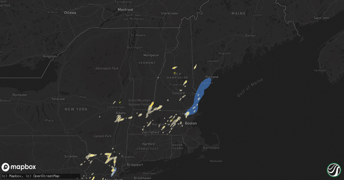
Hail Map in New Hampshire on September 8, 2023
Get this storm
September 8 map
$229
one time, instant access
Download today. No call, no setup
Keep the $229
Bought the map and want the full workflow? Apply the entire $229 to a subscription within 7 days. None of it is wasted.
Every map, not just this one
This buys you this map. Subscription and you get every map we run, in the markets you choose from a few cities to whole states to nationwide. Plus real-time alerts the moment a storm fires.
Contact data
Name, contact info, occupancy, even credit band for addresses in the footprint. You go from where it hit to who to call.
Become the source they trust
Unlimited branding weather history reports on demand. You already have the documented answer ready for the property owner, and you are the one who showed up with it.
Property data and RoofTrace estimates
Pull up any address you have got, its value and the exact code rules for that jurisdiction, straight from One Click Code. Then RoofTrace estimates the squares, pitch, and roof value, priced the way you price.
Storm reports in New Hampshire
New Hampshire
| Date | Description |
|---|---|
| 09/08/20235:45 PM CDT | Trees and wires down. |
| 09/08/20235:41 PM CDT | Trees and wires down. |
| 09/08/20235:36 PM CDT | Trees and wires down on main street in dublin. |
| 09/08/20235:35 PM CDT | Trees down on route 137. |
| 09/08/20235:25 PM CDT | Trees and wires down w lake road. |
| 09/08/20235:13 PM CDT | Trees and wires down. |
| 09/08/20235:10 PM CDT | Trees and wires down. |
| 09/08/20235:07 PM CDT | Trees and wires down. |
| 09/08/20233:57 PM CDT | Numerous reports of trees and wires down reported to claremont dispatch. Time estimated by radar. |
| 09/08/20233:25 PM CDT | A local report indicates 1.00 inch wind near 3 NW Alton |
| 09/08/20233:25 PM CDT | A local report indicates 1.00 inch wind near Troy |
| 09/08/20233:02 PM CDT | A local report indicates 1.50 inch wind near 4 WSW Westmoreland |
| 09/08/20233:00 PM CDT | A local report indicates 1.00 inch wind near 3 WNW Chesterfield |
| 09/08/20232:53 PM CDT | Power poles broken and branches down. Time estimated by radar. |
| 09/08/20232:47 PM CDT | Trained spotter sent pictures via social media of widespread tree damage... Including large branches greater than 6 inches covering roads and a car. Also a large tree g |
| 09/08/20232:35 PM CDT | Trees and power lines down. |
| 09/08/20231:56 PM CDT | Reports of trees and branches down in the city of nahua. Time estimated by radar. |
All States Impacted by Hail Map on September 8, 2023
Cities Impacted by Hail Map on September 8, 2023
- Howard, KS
- Amity, AR
- Kirby, AR
- Murfreesboro, AR
- Delight, AR
- Prescott, AR
- Blevins, AR
- Crescent City, FL
- Bunnell, FL
- Coventry, CT
- Storrs Mansfield, CT
- West Brookfield, MA
- Brookfield, MA
- Provencal, LA
- Mayo, FL
- Eustis, FL
- Umatilla, FL
- Woodville, MS
- Marksville, LA
- Alexandria, LA
- Hessmer, LA
- Lecompte, LA
- Ocala, FL
- Orlando, FL
- Aynor, SC
- Monroe, LA
- Mount Ida, AR
- Norman, AR
- Effie, LA
- Slagle, LA
- Leesville, LA
- Caddo Gap, AR
- Tabor City, NC
- Emmet, AR
- Plain Dealing, LA
- Palm Coast, FL
- Christmas, FL
- Gilbert, LA
- Evergreen, NC
- Bladenboro, NC
- Rosston, AR
- Chadbourn, NC
- Perry, FL
- Daytona Beach, FL
- Port Orange, FL
- White Oak, NC
- Tar Heel, NC
- Oden, AR
- Mena, AR
- Winnsboro, LA
- Wisner, LA
- Okolona, AR
- Glenwood, AR
- Antoine, AR
- Langley, AR
- Bolton, CT
- Hebron, CT
- Andover, CT
- Saint Cloud, FL
- Florien, LA
- Hampton, AR
- Seville, FL
- Winter Garden, FL
- Ocoee, FL
- Punta Gorda, FL
- Green Sea, SC
- Loris, SC
- Cocoa, FL
- Deville, LA
- Titusville, FL
- Seneca, MO
- North Brookfield, MA
- Barryville, NY
- Pond Eddy, NY
- Shohola, PA
- Glen Spey, NY
- Sparrow Bush, NY
- Millrift, PA
- East Rutherford, NJ
- Rutherford, NJ
- Lyndhurst, NJ
- Wallington, NJ
- Carlstadt, NJ
- Lodi, NJ
- Rochelle Park, NJ
- Hasbrouck Heights, NJ
- Garfield, NJ
- Wood Ridge, NJ
- South Hackensack, NJ
- Moonachie, NJ
- Maywood, NJ
- Bogota, NJ
- Hackensack, NJ
- Little Ferry, NJ
- Teterboro, NJ
- Ridgefield Park, NJ
- River Edge, NJ
- Emerson, NJ
- Westwood, NJ
- New Milford, NJ
- Oradell, NJ
- Teaneck, NJ
- Paramus, NJ
- Orangeburg, NY
- Tappan, NY
- Dumont, NJ
- Demarest, NJ
- Palisades, NY
- Northvale, NJ
- Cresskill, NJ
- Tenafly, NJ
- Bergenfield, NJ
- Norwood, NJ
- Closter, NJ
- Harrington Park, NJ
- Haworth, NJ
- Lake Charles, LA
- Hackberry, LA
- Sulphur, LA
- Sparkill, NY
- Blauvelt, NY
- Nyack, NY
- Piermont, NY
- Blooming Grove, NY
- Washingtonville, NY
- Salisbury Mills, NY
- Rock Tavern, NY
- Brattleboro, VT
- West Chesterfield, NH
- Hinsdale, NH
- Winchester, NH
- Troy, NH
- Swanzey, NH
- Westmoreland, NH
- Putney, VT
- Morrisville, NC
- Raleigh, NC
- Hampton Falls, NH
- Stratham, NH
- Portsmouth, NH
- Newmarket, NH
- Greenland, NH
- Seabrook, NH
- Rye, NH
- Kittery, ME
- Amesbury, MA
- Rye Beach, NH
- North Hampton, NH
- Durham, NH
- New Castle, NH
- Hampton, NH
- East Kingston, NH
- Salisbury, MA
- Exeter, NH
- York, ME
- Cape Neddick, ME
- Eliot, ME
- Madbury, NH
- Dover, NH
- Kittery Point, ME
- Ogunquit, ME
- South Berwick, ME
- Wells, ME
- Kennebunkport, ME
- Kennebunk, ME
- North Berwick, ME
- Rollinsford, NH
- Old Orchard Beach, ME
- Saco, ME
- Biddeford Pool, ME
- South Portland, ME
- Ocean Park, ME
- Biddeford, ME
- Berwick, ME
- Scarborough, ME
- Sanford, ME
- Alfred, ME
- Buxton, ME
- Newfields, NH
- Newburyport, MA
- Ipswich, MA
- Byfield, MA
- Rowley, MA
- Newbury, MA
- Merrimac, MA
- Andover, MA
- Haverhill, MA
- Groveland, MA
- West Newbury, MA
- Boxford, MA
- Lowell, MA
- Georgetown, MA
- North Andover, MA
- Tewksbury, MA
- Topsfield, MA
- Lawrence, MA
- South Hamilton, MA
- Wilmington, MA
- Billerica, MA
- Middleton, MA
- North Billerica, MA
- North Reading, MA
- Methuen, MA
- Woodstock, VA
- Aldie, VA
- Chantilly, VA
- Sterling, VA
- Ashburn, VA
- Plymouth, NH
- Holderness, NH
- Centreville, VA
- Catharpin, VA
- Mount Jackson, VA
- Broadway, VA
- Timberville, VA
- Walters, OK
- Fuquay Varina, NC
- Willow Spring, NC
- Haymarket, VA
- Frederick, OK
- Hollister, OK
- Loveland, OK
- Temple, OK
- Perkinsville, VT
- Springfield, VT
- Rowe, MA
- Maringouin, LA
- Livonia, LA
- Shawmut, MT
- Alton Bay, NH
- Columbus, NJ
- Carmel, NY
- Milton, NY
- Highland, NY
- Wallkill, NY
- Highland Falls, NY
- Bear Mountain, NY
- Fort Montgomery, NY
- Garrison, NY
- Kissimmee, FL
- Spring Hope, NC
- Franklin, LA
- Ryegate, MT
- Shirley, MA
- Groton, MA
- Stow, MA
- Vincentown, NJ
- Cary, NC
- Apex, NC
- Brimfield, MA
- Warren, MA
- East Brookfield, MA
- Quinton, OK
- Rose Hill, NC
- Oakdale, LA
- Fulks Run, VA
- Bergton, VA
- Greenfield, MA
- Bernardston, MA
- Colrain, MA
- New Milford, CT
- Bridgewater, CT
- Washington Depot, CT
- New Fairfield, CT
- Sherman, CT
- Frederica, DE
- Magnolia, DE
- Moore Haven, FL
- Cranford, NJ
- Roselle, NJ
- Roselle Park, NJ
- Clark, NJ
- Linden, NJ
- Hanna, OK
- Eufaula, OK
- Weleetka, OK
- Henryetta, OK
- Kenilworth, NJ
- Rahway, NJ
- White Sulphur Springs, MT
- Madison, NJ
- Chatham, NJ
- Green Village, NJ
- Florham Park, NJ
- Milford, DE
- Milton, DE
- Lincoln, DE
- Ellendale, DE
- Crowley, LA
- Morse, LA
- Patterson, LA
- Broad Run, VA
- Rocky Mount, NC
- Centreville, MS
- Gloster, MS
- Crosby, MS
- Pinetops, NC
- Macclesfield, NC
- Elm City, NC
- Dudley, MA
- Georgetown, DE
- Jasper, TX
- Ballston Lake, NY
- Garland, NC
- Clinton, NC
- Port Arthur, TX
- Beaumont, TX
- Stephentown, NY
- Pittsfield, MA
- New Lebanon, NY
- Pineville, LA
- Devers, TX
- New Egypt, NJ
- Browns Mills, NJ
- Pemberton, NJ
- Wrightstown, NJ
- Jobstown, NJ
- Mount Holly, NJ
- Manchester Township, NJ
- Trenton, NJ
- Allentown, NJ
- Chesterfield, NJ
- Joint Base Mdl, NJ
- Jackson, NJ
- Lakehurst, NJ
- Cookstown, NJ
- Monroe, NY
- Warwick, NY
- Greenwood Lake, NY
- Maurertown, VA
- Edinburg, VA
- Schenectady, NY
- Amsterdam, NY
- Ballston Spa, NY
- Florence, MA
- Easthampton, MA
- Gainesville, VA
- Gilmanton Iron Works, NH
- Alton, NH
- Markham, VA
- Linden, VA
- Bolton, MA
- Conway, SC
- Staten Island, NY
- Elizabeth, NJ
- Elizabethport, NJ
- Hillside, NJ
- Harbeson, DE
- Tomkins Cove, NY
- Garnerville, NY
- West Haverstraw, NY
- Stony Point, NY
- Buchanan, NY
- Haverstraw, NY
- Verplanck, NY
- Montrose, NY
- Hazlet, NJ
- Keyport, NJ
- Cliffwood, NJ
- Morganville, NJ
- Matawan, NJ
- Holmdel, NJ
- Fayetteville, NC
- Adams, MA
- Stockton, NJ
- Ringoes, NJ
- Flemington, NJ
- Lake Placid, FL
- Worcester, MA
- Auburn, MA
- Millbury, MA
- Brownfield, ME
- Wewoka, OK
- Okemah, OK
- Wetumka, OK
- Mamou, LA
- Ville Platte, LA
- Castle, OK
- Paden, OK
- Holdenville, OK
- Fellsmere, FL
- Palm Bay, FL
- Donaldsonville, LA
- Belle Rose, LA
- Goldsboro, NC
- White Castle, LA
- Plaquemine, LA
- Sudbury, MA
- Framingham, MA
- Pittstown, NJ
- Annandale, NJ
- Clinton, NJ
- Frenchtown, NJ
- Camden Wyoming, DE
- Jackson, LA
- Saint Francisville, LA
- Woodcliff Lake, NJ
- Township Of Washington, NJ
- Ridgewood, NJ
- Saddle River, NJ
- Park Ridge, NJ
- Ho Ho Kus, NJ
- Hillsdale, NJ
- Oakham, MA
- Rutland, MA
- Orange, TX
- Vinton, LA
- Sebring, FL
- Lancaster, MA
- Lunenburg, MA
- Leominster, MA
- Campbell Hall, NY
- Ivanhoe, NC
- Harrells, NC
- Coats, NC
- Benson, NC
- Vernon, VT
- Northfield, MA
- Canal Point, FL
- Union, NJ
- Pitkin, LA
- Saddle Brook, NJ
- Durham, NC
- Natick, MA
- Sherborn, MA
- Boxborough, MA
- Littleton, MA
- Clinton, MA
- Harvard, MA
- Berlin, MA
- Hudson, MA
- Luray, VA
- Dulac, LA
- Two Dot, MT
- Chichester, NH
- Hartshorne, OK
- Mcalester, OK
- Farmingdale, NJ
- Freehold, NJ
- Marlboro, NJ
- Colts Neck, NJ
- Vero Beach, FL
- Okeechobee, FL
- Stuyvesant, NY
- Valatie, NY
- Schodack Landing, NY
- Niverville, NY
- Middletown, NY
- Jeanerette, LA
- East Nassau, NY
- Nassau, NY
- Sperryville, VA
- Bentonville, VA
- Washington, VA
- Holland, MA
- Fiskdale, MA
- Sturbridge, MA
- Marshall, VA
- Middleburg, VA
- Upperville, VA
- Lewes, DE
- Salem, NJ
- Maybrook, NY
- Goshen, NY
- Chester, NY
- Montgomery, NY
- Tuxedo Park, NY
- Wilson, NC
- Hannacroix, NY
- Kinderhook, NY
- West Coxsackie, NY
- New Baltimore, NY
- Coeymans, NY
- Selkirk, NY
- Ravena, NY
- Dover, DE
- Mittie, LA
- Oberlin, LA
- Thiells, NY
- Naylor, GA
- Monterey, LA
- Winnie, TX
- Melbourne, FL
- Batson, TX
- New Windsor, NY
- Harriman, NY
- Central Valley, NY
- Highland Mills, NY
- Otisville, NY
- Boley, OK
- Bristow, OK
- Depew, OK
- Stroud, OK
- Lebanon, NJ
- Califon, NJ
- Norwood, LA
- Ashford, CT
- Sloatsburg, NY
- Hillburn, NY
- Pottstown, PA
- Savoy, MA
- The Plains, VA
- Porter, ME
- Denmark, ME
- La Grange, NC
- Cheneyville, LA
- Chapel Hill, NC
- Mount Olive, NC
- Faison, NC
- Warsaw, NC
- Loxahatchee, FL
- Clinton, LA
- Fremont, NC
- Perkasie, PA
- Chalfont, PA
- Fountainville, PA
- Pipersville, PA
- Doylestown, PA
- Lansdale, PA
- New Hope, PA
- Elverson, PA
- Climax, NY
- Greenville, NY
- Castleton On Hudson, NY
- South Bethlehem, NY
- Earlton, NY
- Surprise, NY
- Freehold, NY
- Coeymans Hollow, NY
- Smyrna, DE
- Kingwood, TX
- Splendora, TX
- New Caney, TX
- Porter, TX
- Marlborough, MA
- Southborough, MA
- Middlesex, NC
- Monsey, NY
- Nashville, NC
- Castalia, NC
- Harman, WV
- Whitmer, WV
- Seneca Rocks, WV
- Jefferson, NY
- Summit, NY
- Delaplane, VA
- Ethel, LA
- Long Valley, NJ
- Kenansville, FL
- Gilmanton, NH
- Lakewood, NJ
- Howell, NJ
- New Iberia, LA
- Lottie, LA
- Fordoche, LA
- Glen Gardner, NJ
- Magnolia, NC
- Whitehall, MT
- Grosse Tete, LA
- Lanesborough, MA
- Eastford, CT
- Felton, DE
- Stedman, NC
- Indianola, OK
- Center Barnstead, NH
- Toms Brook, VA
- Loudon, NH
- Rockledge, FL
- Townsend, DE
- Sewaren, NJ
- Port Reading, NJ
- Perth Amboy, NJ
- Keasbey, NJ
- Woodbridge, NJ
- Avenel, NJ
- Great Falls, VA
- Chester, VT
- Saint Martinville, LA
- Plymouth, NC
- Roper, NC
- Huguenot, NY
- Matamoras, PA
- Hawley, PA
- Greeley, PA
- Milford, PA
- Lucama, NC
- Breaux Bridge, LA
- Laurel, DE
- Boylston, MA
- Acton, MA
- Shrewsbury, MA
- West Boylston, MA
- Northborough, MA
- Seven Springs, NC
- Dudley, NC
- Wade, NC
- Leesburg, VA
- Englishtown, NJ
- Millstone Township, NJ
- Angier, NC
- Dunn, NC
- Millsboro, DE
- Abbeville, LA
- Youngsville, LA
- Erath, LA
- Delcambre, LA
- Canadian, OK
- Southfields, NY
- Montvale, NJ
- Spring Valley, NY
- Peekskill, NY
- West Nyack, NY
- Nanuet, NY
- Suffern, NY
- West Point, NY
- New City, NY
- Cortlandt Manor, NY
- Pearl River, NY
- Zebulon, NC
- Woodstock, CT
- Woodstock Valley, CT
- Glady, WV
- Hopewell Junction, NY
- Stantonsburg, NC
- Black Creek, NC
- Pikeville, NC
- Bedford, MA
- Burlington, MA
- Dayton, MD
- Ellicott City, MD
- Clarksville, MD
- West Friendship, MD
- Magnolia, TX
- Pinehurst, TX
- Rapid City, SD
- Ellsworth Afb, SD
- Box Elder, SD
- Davidson, OK
- Marriottsville, MD
- Windsor Mill, MD
- Randallstown, MD
- Woodstock, MD
- Sparks Glencoe, MD
- Cockeysville, MD
- Hunt Valley, MD
- Stevenson, MD
- Owings Mills, MD
- Pikesville, MD
- Phoenix, MD
- Gladstone, VA
- Buckingham, VA
- Dillwyn, VA
- Monkton, MD
- Baldwin, MD
- New Underwood, SD
- Owanka, SD
- Gainesville, TX
- Clarksville, TX
- Detroit, TX
- Bagwell, TX
- Bogata, TX
- Mount Pleasant, TX
- Talco, TX
- Cookville, TX
- Wasta, SD
- New Canton, VA
- Bremo Bluff, VA
- Palmyra, VA
- Fork Union, VA
- Arvonia, VA
- Diana, TX
- Longview, TX
- Hallsville, TX
- Sterling, MA
- Wilmington, DE
- Marcus Hook, PA
- Garnet Valley, PA
- Chadds Ford, PA
- Montchanin, DE
- Rockland, DE
- Round Lake, NY
- Mechanicville, NY
- Fort Worth, TX
- Newark, TX
- Haslet, TX
- Rhome, TX
- Azle, TX
- Boyd, TX
- Aledo, TX
- Naval Air Station Jrb, TX
- Franklin, WV
- Upper Tract, WV
- Crowley, TX
- Spencerville, OK
- Rattan, OK
- Fort Towson, OK
- Sawyer, OK
- Joshua, TX
- Burleson, TX
- Cleburne, TX
- Antlers, OK
- Soper, OK
- Hugo, OK
- Godley, TX
- Keene, TX
- Alvarado, TX
- Lillian, TX
- Mansfield, TX
- Granbury, TX
- Honey Grove, TX
- Petty, TX
- Sumner, TX
- Rio Vista, TX
- Grandview, TX
- Venus, TX
- Midlothian, TX
- Blum, TX
- Hermosa, SD
- Grandfield, OK
- Tolland, CT
- Port Murray, NJ
- Washington, NJ
- Belvidere, NJ
- Windsor, CT
- Bloomfield, CT
- Daingerfield, TX
- Hackettstown, NJ
- Phenix, VA
- Garryowen, MT
- McHenry, MD
- Accident, MD
- Shepherd, MT
- Amherst, MA
- Leverett, MA
- Canadensis, PA
- Campton, NH
- Thornton, NH
- Williamsburg, MA
- Haydenville, MA
- Leeds, MA
- Hume, VA
- Huntly, VA
- Manchester, NH
- Hooksett, NH
- Princeton, NJ
- Daisy, OK
- Charlemont, MA
- Tatum, TX
- Hubbardston, MA
- Muenster, TX
- Gaithersburg, MD
- Shelburne Falls, MA
- Windsor, VT
- Feura Bush, NY
- Glenmont, NY
- Delmar, NY
- Glenelg, MD
- Sykesville, MD
- Chatsworth, NJ
- Bordentown, NJ
- Candia, NH
- Deerfield, NH
- Cumberland, VA
- Nashoba, OK
- Elkton, MD
- North East, MD
- Ahoskie, NC
- Como, NC
- Murfreesboro, NC
- Boling, TX
- Pledger, TX
- Bath, PA
- Tenaha, TX
- Purcellville, VA
- Kilgore, TX
- Ashland, MA
- Franklin, VA
- Newsoms, VA
- Courtland, VA
- Easton, PA
- Bangor, PA
- Gary, TX
- Northampton, MA
- Pylesville, MD
- Fawn Grove, PA
- Peach Bottom, PA
- Drumore, PA
- Delta, PA
- Whiteford, MD
- Ardmore, OK
- Springer, OK
- Malta, MT
- Columbia, MD
- Valliant, OK
- Ringold, OK
- High Bridge, NJ
- Princeton, MA
- Fitchburg, MA
- Columbia, VA
- Haworth, OK
- Waldorf, MD
- Lutherville Timonium, MD
- Poolesville, MD
- Potomac, MD
- Germantown, MD
- Ashuelot, NH
- Stafford Springs, CT
- Brookneal, VA
- Carthage, TX
- Charlotte Court House, VA
- Halifax, VA
- Crystal Hill, VA
- Randolph, VA
- Nathalie, VA
- Electra, TX
- Harrold, TX
- Piedmont, SD
- Jefferson, MA
- Brownsville, VT
- Oxford, MA
- Cresco, PA
- De Kalb, TX
- Royalston, MA
- Granville, MA
- Southampton, MA
- Hadley, MA
- Hatfield, MA
- Finley, OK
- Robbinsville, NJ
- Oxford, CT
- Waterbury, CT
- Prospect, CT
- Naugatuck, CT
- Farmville, VA
- Dingmans Ferry, PA
- Clayton, OK
- Pittsburg, OK
- Snow, OK
- Arthur City, TX
- Ashfield, MA
- West Halifax, VT
- Conway, MA
- Chadron, NE
- Rileyville, VA
- Blandford, MA
- Russell, MA
- Gilbertsville, PA
- Van Vleck, TX
- Sweeny, TX
- Port Royal, VA
- Criders, VA
- Clewiston, FL
- Broken Bow, OK
- Wright City, OK
- Red House, VA
- Wilburton, OK
- Paxton, MA
- Holden, MA
- Brainard, NY
- White Plains, MD
- Wall, SD
- Dodson, MT
- Windsor, MA
- Ware, MA
- Scottsville, VA
- Geronimo, OK
- Bethany, CT
- Beacon Falls, CT
- Pasadena, MD
- Idabel, OK
- Bryantown, MD
- Foreman, AR
- Avery, TX
- Annona, TX
- West Lebanon, NH
- Lebanon, NH
- Plantsville, CT
- Cheshire, CT
- Southington, CT
- Huntington, MA
- Rockville, MD
- Prospect, VA
- Reisterstown, MD
- Glen Arm, MD
- Newburgh, NY
- Wappingers Falls, NY
- Ore City, TX
- Harleton, TX
- Jefferson, TX
- Henderson, TX
- Parkton, MD
- Hydes, MD
- White Hall, MD
- Cooksville, MD
- Glenwood, MD
- Jarrettsville, MD
- Quarryville, PA
- Street, MD
- Hancock, NH
- Bennington, NH
- Antrim, NH
- Brogue, PA
- Airville, PA
- Ochopee, FL
- Covington, TX
- Roxton, TX
- Mabank, TX
- Trinidad, TX
- Dike, TX
- Sulphur Springs, TX
- Olney, MD
- Weatherford, TX
- Cresson, TX
- Webster, MA
- Malakoff, TX
- Bennington, OK
- Boswell, OK
- Lufkin, TX
- Reklaw, TX
- Laneville, TX
- Cushing, TX
- Charlotte Hall, MD
- Bokchito, OK
- Caddo, OK
- Caney, OK
- Atoka, OK
- Hurst, TX
- Nacogdoches, TX
- Grapeland, TX
- Alto, TX
- Wells, TX
- Arlington, TX
- Brookston, TX
- Gibson Island, MD
- Rock Hall, MD
- Banco, VA
- Madison, VA
- Washington, DC
- La Plata, MD
- Brandywine, MD
- Pomona Park, FL
- Nokesville, VA
- Catlett, VA
- Woodville, VA
- Euless, TX
- Bedford, TX
- Tupelo, OK
- Wapanucka, OK
- Chester, TX
- Athens, TX
- Kemp, TX
- Kerens, TX
- Aston, PA
- Media, PA
- Chester Heights, PA
- Glen Mills, PA
- Kennedale, TX
- Huntington, TX
- Riverton, WV
- Pittsburg, TX
- Newtown Square, PA
- Yorklyn, DE
- Hockessin, DE
- Sour Lake, TX
- Stonewall, OK
- Crozet, VA
- Free Union, VA
- Woodville, TX
- Paris, TX
- Tishomingo, OK
- Milburn, OK
- Roff, OK
- Chester Gap, VA
- Montalba, TX
- Gilmer, TX
- Edgewater, MD
- Annapolis, MD
- Broaddus, TX
- Brookeville, MD
- Bethesda, MD
- Vienna, VA
- McLean, VA
- Manassas, VA
- Warrenton, VA
- Fort McCoy, FL
- Clinton, MD
- Springtown, TX
- Jordan, MT
- Larue, TX
- Leesburg, TX
- Moyers, OK
- Kennard, TX
- Denton, MD
- Easton, MD
- Preston, MD
- Haverford, PA
- Bryn Mawr, PA
- Frankston, TX
- Lindsay, TX
- Oakton, VA
- Reston, VA
- Herndon, VA
- Fairfax, VA
- Palestine, TX
- Upper Black Eddy, PA
- Gibbstown, NJ
- Houston, TX
- Humble, TX
- Spring, TX
- Oxon Hill, MD
- Montgomery Village, MD
- Washington Grove, MD
- Derwood, MD
- Fallston, MD
- Fork, MD
- Falls Church, VA
- Naval Anacost Annex, DC
- Newark, DE
- Andover, SD
- Groton, SD


