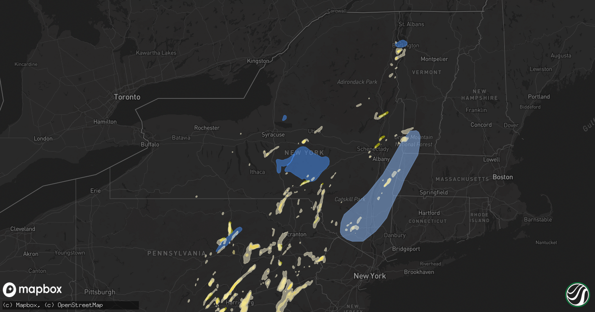
Hail Map in New York on September 7, 2023
Get this storm
September 7 map
$229
one time, instant access
Download today. No call, no setup
Keep the $229
Bought the map and want the full workflow? Apply the entire $229 to a subscription within 7 days. None of it is wasted.
Every map, not just this one
This buys you this map. Subscription and you get every map we run, in the markets you choose from a few cities to whole states to nationwide. Plus real-time alerts the moment a storm fires.
Contact data
Name, contact info, occupancy, even credit band for addresses in the footprint. You go from where it hit to who to call.
Become the source they trust
Unlimited branding weather history reports on demand. You already have the documented answer ready for the property owner, and you are the one who showed up with it.
Property data and RoofTrace estimates
Pull up any address you have got, its value and the exact code rules for that jurisdiction, straight from One Click Code. Then RoofTrace estimates the squares, pitch, and roof value, priced the way you price.
Storm reports in New York
New York
| Date | Description |
|---|---|
| 09/07/20236:58 PM CDT | Tree and wires down on lake nebo road in fort ann about a mile from copeland pond |
| 09/07/20236:50 PM CDT | Tree down on wires at old mill street. |
| 09/07/20236:50 PM CDT | Rt 22 closed between rt 43 and wyomanock rd due to downed trees and wires in the roadway. Time estimated from radar. |
| 09/07/20236:50 PM CDT | Downed tree. Time radar estimated. |
| 09/07/20236:50 PM CDT | Tree down on wires at old mil |
| 09/07/20236:44 PM CDT | Tree on house. Time radar estimated. |
| 09/07/20236:43 PM CDT | Tree and wires burning at 539 route 32. |
| 09/07/20236:41 PM CDT | Wires down at 1224 route 17k. |
| 09/07/20236:38 PM CDT | Wires down. Time radar estimated. |
| 09/07/20236:38 PM CDT | Trees and wires down. Time radar estimated. |
| 09/07/20236:36 PM CDT | Trees and wires down. Time radar estimated. |
| 09/07/20236:32 PM CDT | Tree down at county route 17 and waterbury rd in redfield. |
| 09/07/20236:32 PM CDT | Trees and wires down on mccaw rd in redfield. |
| 09/07/20236:30 PM CDT | Tree and wires down at woodcock mountain road and adelaide lane. |
| 09/07/20236:30 PM CDT | Tree down on house per photo on social media. |
| 09/07/20236:29 PM CDT | Tree down on north jefferson st in pulaski. |
| 09/07/20236:25 PM CDT | Trees and wires down. Time radar estimated. |
| 09/07/20236:23 PM CDT | Tree and wires down at 380 bullville road. |
| 09/07/20236:23 PM CDT | Tree down on marsh road. |
| 09/07/20236:17 PM CDT | A local report indicates 1.00 inch wind near 1 NE Bloomingburg |
| 09/07/20236:14 PM CDT | Wires down and burning on route 211 east between hidden valley drive and goshen turnpike. |
| 09/07/20236:11 PM CDT | Trees and wires down. |
| 09/07/20236:11 PM CDT | Multiple trees and wires down. |
| 09/07/20236:06 PM CDT | Tree down on red schoolhouse rd. |
| 09/07/20236:06 PM CDT | Trees down. |
| 09/07/20236:05 PM CDT | Tree down with wires burning on sutherland road between county route 61 and dobbin hill road in jackson... Ny |
| 09/07/20236:05 PM CDT | Trees down. |
| 09/07/20236:05 PM CDT | Tree and wires down county route 64. |
| 09/07/20236:04 PM CDT | Wires down near state route 46 and walker road. |
| 09/07/20236:04 PM CDT | Trees down. |
| 09/07/20236:04 PM CDT | Tree down at state route 3 and beesaw rd. |
| 09/07/20236:04 PM CDT | Trees down. |
| 09/07/20236:01 PM CDT | Tree down on route 64. |
| 09/07/20235:58 PM CDT | Corrects report source in previous tstm wnd dmg report from fulton. Tree down on west 4th street in fulton. |
| 09/07/20235:58 PM CDT | Tree down at state route 49 and canterbury way in hastings. |
| 09/07/20235:50 PM CDT | Trees down. |
| 09/07/20235:47 PM CDT | Several trees down and a snapped powerline in schodack landing. |
| 09/07/20235:45 PM CDT | Trees and wires down. |
| 09/07/20235:44 PM CDT | Tree down on murphys rd |
| 09/07/20235:34 PM CDT | Trees and wire down. |
| 09/07/20235:30 PM CDT | Trees down. |
| 09/07/20235:30 PM CDT | Trees down. |
| 09/07/20235:25 PM CDT | Trees down near stevens road and grant ave... Relayed by nws buf. |
| 09/07/20235:25 PM CDT | Trees down. |
| 09/07/20235:23 PM CDT | Trees and wires down. |
| 09/07/20235:21 PM CDT | Trees down. |
| 09/07/20235:20 PM CDT | Trees down. |
| 09/07/20235:18 PM CDT | Numerous trees down. |
| 09/07/20235:15 PM CDT | Tree down on road. |
| 09/07/20235:13 PM CDT | Tree down on road. |
| 09/07/20235:13 PM CDT | Tree down on road. |
| 09/07/20235:11 PM CDT | Trees and wires down on wright town road |
| 09/07/20235:10 PM CDT | Tree on house on neilson ave |
| 09/07/20235:09 PM CDT | Wires down on union ave and henning road. |
| 09/07/20235:07 PM CDT | Trees and wires down on gronczniak road. |
| 09/07/20235:05 PM CDT | Tree down on road. |
| 09/07/20235:05 PM CDT | Wires down on lake road and grace moore road. |
| 09/07/20235:05 PM CDT | Trees down. |
| 09/07/20235:05 PM CDT | Wires down on route 75 and burrello court |
| 09/07/20235:05 PM CDT | Tree down on road. |
| 09/07/20235:05 PM CDT | Tree down on road |
| 09/07/20235:02 PM CDT | Trees down. |
| 09/07/20235:01 PM CDT | Received a report of dime to quarter size inch hail near stillwater. |
| 09/07/20235:01 PM CDT | Received a report of nickel to quarter size inch hail near the malta community center. |
| 09/07/20235:00 PM CDT | Tree down blocking the road. Time estimated from radar. |
| 09/07/20234:55 PM CDT | Tree down on road. |
| 09/07/20234:45 PM CDT | Trees down. |
| 09/07/20234:44 PM CDT | Corrects previous tstm wnd dmg report from 1 nw locke. Trees down. |
| 09/07/20234:41 PM CDT | Report of quarter size hail |
| 09/07/20234:40 PM CDT | Corrects previous tstm wnd dmg report from 4 nne groton. Trees down. |
| 09/07/20234:39 PM CDT | Trees down. |
| 09/07/20234:36 PM CDT | Trees down. |
| 09/07/20234:31 PM CDT | Tree and wires down on road. |
| 09/07/20234:30 PM CDT | Trees down. |
| 09/07/20234:28 PM CDT | Tree and wires down on road. |
| 09/07/20234:24 PM CDT | Tree and wires down. |
| 09/07/20234:22 PM CDT | Tree down on route 8 in johnsburg. Time estimated from radar. |
| 09/07/20234:20 PM CDT | Several trees down across road. |
| 09/07/20234:05 PM CDT | Tree down on occupied camper. Unknown injuries. |
| 09/07/20234:03 PM CDT | Tree on powerline near the transfer station in guilderland. |
| 09/07/20233:55 PM CDT | Tree down on the road. |
| 09/07/20233:50 PM CDT | Multiple trees down and power poles snapped. |
| 09/07/20233:45 PM CDT | Tree down on house. Power pole snapped in half. |
| 09/07/20233:45 PM CDT | Tree and wires down. |
| 09/07/20233:45 PM CDT | Multiple trees and wires down. |
| 09/07/20233:40 PM CDT | Multiple trees down around owego. |
| 09/07/20233:38 PM CDT | A couple of trees down in the town of summit near clapper hollow |
| 09/07/20233:06 PM CDT | Tree and wires down. |
| 09/07/20232:41 PM CDT | Multiple trees down. |
| 09/07/20232:41 PM CDT | Multiple trees down. |
| 09/07/20232:36 PM CDT | A local report indicates 1.00 inch wind near Afton |
| 09/07/20231:50 PM CDT | Single tree down on roadway in town. |
| 09/07/202312:43 PM CDT | A local report indicates 1.25 inch wind near Willsboro Point |
| 09/06/20238:44 PM CDT | Trees down. |
| 09/06/20238:40 PM CDT | Trees down. |
| 09/06/20238:30 PM CDT | Tree down on ash grove road between chesnut hill road and mckie hollow road in white creek. |
| 09/06/20238:22 PM CDT | Wires and transformer down on county route 68 between state line road and niles road. |
| 09/06/20238:16 PM CDT | Tree down. Time radar estimated. |
| 09/06/20238:16 PM CDT | Tree down on wires blocking niles road between meeting house and gannon road in white creek |
| 09/06/20238:15 PM CDT | Reports of multiple trees and power lines down in hoosick resulting in numerous power outages. Time estimated from radar. |
| 09/06/20238:14 PM CDT | Tree on wires. Time radar estimated. |
| 09/06/20238:10 PM CDT | Several trees down and a snapped powerline in schodack landing. |
| 09/06/20237:50 PM CDT | Rt 22 closed between rt 43 and wyomanock rd due to downed trees and wires in the roadway. Time estimated from radar. |
| 09/06/20237:49 PM CDT | Wires down on burgoyne road |
| 09/06/20237:45 PM CDT | Tree down on davis ave. |
| 09/06/20237:42 PM CDT | Trees and wires downed on lake nebo road |
| 09/06/20237:39 PM CDT | Road closed due to downed tree on wires. Time radar estimated. |
| 09/06/20237:36 PM CDT | A local report indicates 60 MPH wind near Buckleyville |
| 09/06/20237:31 PM CDT | Tree snapped and came down on wires connected to a residential home. |
| 09/06/20237:30 PM CDT | A local report indicates 61 MPH wind near Schodack |
| 09/06/20237:30 PM CDT | Time estimated from radar. |
| 09/06/20237:29 PM CDT | Downed poles and wires causing all lanes to be closed on ny 9l from county route 27 to pickle hill road |
| 09/06/20237:15 PM CDT | A local report indicates 60 MPH wind near Copake |
| 09/06/20237:11 PM CDT | Tree down blocking hodge rd in the town of watson. |
All States Impacted by Hail Map on September 7, 2023
Cities Impacted by Hail Map on September 7, 2023
- Romney, WV
- Fort Pierre, SD
- Landisburg, PA
- Newville, PA
- Kutztown, PA
- Fleetwood, PA
- Front Royal, VA
- Linden, VA
- Markham, VA
- Delaplane, VA
- Martinsburg, WV
- Falling Waters, WV
- Hedgesville, WV
- Williamsport, MD
- Upperville, VA
- Paris, VA
- Shermans Dale, PA
- New Bloomfield, PA
- Mifflin, PA
- Mifflintown, PA
- Millerstown, PA
- Newport, PA
- Port Royal, PA
- Lewistown, PA
- East Waterford, PA
- Blain, PA
- Duncannon, PA
- Pierre, SD
- Gerrardstown, WV
- Inwood, WV
- Chidester, AR
- Berkeley Springs, WV
- Middletown, VA
- Strasburg, VA
- High View, WV
- Yellow Spring, WV
- Camden, AR
- Hampton, AR
- Wardensville, WV
- Capon Bridge, WV
- Mapleton Depot, PA
- Cassville, PA
- Chester Gap, VA
- Huntly, VA
- Gore, VA
- Cross Junction, VA
- Winchester, VA
- Hayes, SD
- Bloomery, WV
- Great Cacapon, WV
- Oldtown, MD
- Slanesville, WV
- Augusta, WV
- Paw Paw, WV
- Points, WV
- Monticello, GA
- Todd, NC
- Willsboro, NY
- Dudley, PA
- Broad Top, PA
- Bentonville, VA
- Stephens City, VA
- Levels, WV
- Shanks, WV
- Star Tannery, VA
- Honesdale, PA
- Honey Grove, PA
- Ickesburg, PA
- Breinigsville, PA
- New Tripoli, PA
- Liverpool, PA
- Sterling, VA
- Chantilly, VA
- Ashburn, VA
- Milanville, PA
- Tyler Hill, PA
- Millersburg, PA
- Poolesville, MD
- Adamstown, MD
- Point Of Rocks, MD
- Tuscarora, MD
- Dalmatia, PA
- Frederick, MD
- Kempton, PA
- Stroudsburg, PA
- Columbia, NJ
- Lock Haven, PA
- Avis, PA
- Jersey Shore, PA
- Linden, PA
- Trout Run, PA
- Roaring Branch, PA
- Liberty, PA
- Waterville, PA
- East Stroudsburg, PA
- Carlisle, PA
- Mount Holly Springs, PA
- Cogan Station, PA
- Hanover, PA
- Littlestown, PA
- Gettysburg, PA
- Grantville, PA
- Annville, PA
- Keeseville, NY
- Colchester, VT
- Burlington, VT
- Winooski, VT
- Ralston, PA
- Mcadoo, PA
- Hazleton, PA
- Tresckow, PA
- Harrisburg, PA
- Middletown, PA
- Hummelstown, PA
- New Oxford, PA
- Cambridge, VT
- Jeffersonville, VT
- Waterville, VT
- Johnson, VT
- Walton, NY
- Hyde Park, VT
- Morrisville, VT
- Diberville, MS
- Biloxi, MS
- Cockeysville, MD
- Reisterstown, MD
- Sparks Glencoe, MD
- Monkton, MD
- Parkton, MD
- Crawfordville, GA
- Washington, GA
- White Hall, MD
- Towson, MD
- Lutherville Timonium, MD
- Baltimore, MD
- Pikesville, MD
- Gibson, GA
- Avera, GA
- Gulfport, MS
- Pass Christian, MS
- Long Beach, MS
- Waterloo, SC
- Greenwood, SC
- Cross Hill, SC
- Glen Arm, MD
- Phoenix, MD
- Foxworth, MS
- Bristol, TN
- Abingdon, VA
- Shady Valley, TN
- Eastman, GA
- Oxford, NC
- Clarksville, VA
- Buffalo Junction, VA
- Silverstreet, SC
- Newberry, SC
- Stewartstown, PA
- New Freedom, PA
- Felton, PA
- Red Lion, PA
- Glen Rock, PA
- Bethesda, MD
- Kensington, MD
- Garrett Park, MD
- Silver Spring, MD
- Rockville, MD
- Manchester, MD
- Leesville, SC
- Gilbert, SC
- Lexington, SC
- Chapin, SC
- Prosperity, SC
- Afton, NY
- Bainbridge, NY
- Sidney, NY
- Unadilla, NY
- Perry, GA
- Nanticoke, PA
- Wilkes Barre, PA
- Mountain Top, PA
- Wapwallopen, PA
- Marathon, NY
- Plymouth, PA
- Cincinnatus, NY
- McGraw, NY
- McDonough, NY
- Willet, NY
- Smithville Flats, NY
- Schenectady, NY
- Rexford, NY
- Ballston Lake, NY
- Clifton Park, NY
- Oxford, NY
- Greene, NY
- Ballston Spa, NY
- Mechanicville, NY
- Saratoga Springs, NY
- Stillwater, NY
- South Plymouth, NY
- Union Bridge, MD
- Westminster, MD
- Taneytown, MD
- Norwich, NY
- Pitcher, NY
- De Ruyter, NY
- Mount Upton, NY
- Guilford, NY
- Madison, NY
- Oriskany Falls, NY
- Sidney Center, NY
- South New Berlin, NY
- Rock Hill, SC
- South Otselic, NY
- North Pitcher, NY
- Franklin, NY
- Otego, NY
- Gilbertsville, NY
- Wells Bridge, NY
- Smyrna, NY
- Plymouth, NY
- Georgetown, NY
- Earlville, NY
- Sherburne, NY
- New Berlin, NY
- Deansboro, NY
- Morris, NY
- Oneonta, NY
- West Oneonta, NY
- Laurens, NY
- Macon, GA
- Mount Vision, NY
- New Lisbon, NY
- Hamilton, NY
- Hubbardsville, NY
- Edmeston, NY
- West Edmeston, NY
- Hartwick, NY
- West Burlington, NY
- Garrattsville, NY
- Burlington Flats, NY
- Columbia, SC
- Milford, NY
- West Columbia, SC
- Maryland, NY
- Portlandville, NY
- Irmo, SC
- Waterville, NY
- Cooperstown, NY
- Rushville, NE
- Gordon, NE
- Merriman, NE
- Blythewood, SC
- Coatesville, PA
- West Grove, PA
- Cochranville, PA
- Roanoke, VA
- Jarrettsville, MD
- Street, MD
- Pylesville, MD
- Oberlin, LA
- Kinder, LA
- Boyce, LA
- Thompson, PA
- Herrick Center, PA
- New Philadelphia, PA
- Tamaqua, PA
- Harpursville, NY
- Regina, KY
- Hume, VA
- Wellsboro, PA
- Honea Path, SC
- Petersburg, PA
- Huntingdon, PA
- Pine Grove, PA
- Kennebec, SD
- Chester, SC
- Carlisle, SC
- Canadian, TX
- Arnett, OK
- McClure, PA
- Ware Shoals, SC
- Williamsport, PA
- Keyser, WV
- Gordon, GA
- Sibley, LA
- Wells, NY
- Pensacola, FL
- Cantonment, FL
- Saint Thomas, PA
- Fort Loudon, PA
- Mercersburg, PA
- Halifax, PA
- Burke, SD
- Platte, SD
- Trade, TN
- Zionville, NC
- Camilla, GA
- Baconton, GA
- Ninety Six, SC
- La Fayette, NY
- Tully, NY
- Apulia Station, NY
- Columbia, MS
- Kokomo, MS
- Cabin John, MD
- Jeffersonville, GA
- Dry Branch, GA
- Saucier, MS
- Preble, NY
- Homer, NY
- Moravia, NY
- Gray, GA
- Oakfield, GA
- White Plains, GA
- Greensboro, GA
- Schuylkill Haven, PA
- Cressona, PA
- Pottsville, PA
- Newburg, PA
- Downsville, NY
- Covington, LA
- Folsom, LA
- Loranger, LA
- Ponchatoula, LA
- Madisonville, LA
- Hagerstown, MD
- Union Dale, PA
- Wrightsville, GA
- Saluda, SC
- Chappells, SC
- Dry Run, PA
- Spring Run, PA
- Doylesburg, PA
- Harrisonburg, LA
- Sicily Island, LA
- Jonesville, LA
- Milroy, PA
- Allenwood, PA
- East Dublin, GA
- Ringtown, PA
- Girardville, PA
- Shenandoah, PA
- Mahanoy Plane, PA
- Ashland, PA
- Frackville, PA
- Branchdale, PA
- Tremont, PA
- Minersville, PA
- Shrewsbury, PA
- Ferrisburgh, VT
- Elliottsburg, PA
- Trevorton, PA
- Elysburg, PA
- Paxinos, PA
- Shamokin, PA
- Coal Township, PA
- Sunbury, PA
- Dornsife, PA
- Danville, PA
- Catawissa, PA
- Herndon, PA
- Damascus, PA
- Equinunk, PA
- Abbeville, GA
- Rochelle, GA
- Bronwood, GA
- Dawson, GA
- Leesburg, GA
- Milton, PA
- Turbotville, PA
- Watsontown, PA
- Shelburne, VT
- Charlotte, VT
- Essex, NY
- Westport, NY
- Raccoon, KY
- Phyllis, KY
- Oacoma, SD
- Swainsboro, GA
- Adrian, GA
- Dubberly, LA
- Columbia, LA
- Horse Shoe, NC
- Hendersonville, NC
- Evans, GA
- Appling, GA
- Clarks Hill, SC
- Loysville, PA
- Montrose, PA
- Heflin, LA
- Hodges, SC
- Perkinston, MS
- Pelham, GA
- Whigham, GA
- Gainesville, VA
- Haymarket, VA
- Catharpin, VA
- Dickerson, MD
- Jefferson, MD
- Leesburg, VA
- Dublin, GA
- Salem, VA
- Tylertown, MS
- Dauphin, PA
- Port Henry, NY
- Moriah, NY
- Crown Point, NY
- Boyce, VA
- Berryville, VA
- Leary, GA
- Byron, GA
- Batesland, SD
- Pine Ridge, SD
- Juliette, GA
- McIntyre, GA
- Huttig, AR
- Inverness, FL
- Fallston, MD
- Gwynn Oak, MD
- Hydes, MD
- New Park, PA
- Stevenson, MD
- Baldwin, MD
- Owings Mills, MD
- Fawn Grove, PA
- Forest Hill, MD
- Bloomsburg, PA
- Orangeville, PA
- Spring Grove, PA
- Lewisberry, PA
- Etters, PA
- York Haven, PA
- New Cumberland, PA
- Dover, PA
- Soperton, GA
- Hamburg, PA
- Shoemakersville, PA
- Lenhartsville, PA
- Jacksonville, GA
- Lumber City, GA
- Modoc, SC
- Eatonton, GA
- Airville, PA
- Brogue, PA
- Edgefield, SC
- Beech Creek, PA
- Mill Hall, PA
- Sandersville, GA
- Warthen, GA
- Sparta, GA
- Bloomville, NY
- Vergennes, VT
- Climax, GA
- Cairo, GA
- Christiansburg, VA
- New Holland, PA
- Gordonville, PA
- Kinzers, PA
- Paradise, PA
- Franklinton, LA
- Angie, LA
- Princeton, LA
- Haughton, LA
- Palmyra, PA
- York, PA
- Highspire, PA
- Hershey, PA
- Manchester, PA
- Delancey, NY
- Mehoopany, PA
- Brackney, PA
- Dillsburg, PA
- Boiling Springs, PA
- Mechanicsburg, PA
- Mitchell, GA
- Grovetown, GA
- Augusta, GA
- Cadwell, GA
- McRae Helena, GA
- Monticello, FL
- Trenton, SC
- Falls, PA
- Pittston, PA
- Dallas, PA
- Amberson, PA
- Friendsville, PA
- East Earl, PA
- Gap, PA
- Blacksburg, VA
- Shickshinny, PA
- Marrero, LA
- New Orleans, LA
- Westwego, LA
- Narvon, PA
- Millville, PA
- Lairdsville, PA
- Hughesville, PA
- Muncy, PA
- Northumberland, PA
- Benton, PA
- Unityville, PA
- Bastrop, LA
- Fabius, NY
- Port Crane, NY
- Binghamton, NY
- Aldie, VA
- Barren Springs, VA
- Hiwassee, VA
- Hillsville, VA
- Freeland, MD
- Hampstead, MD
- Rentz, GA
- Hawkinsville, GA
- Kathleen, GA
- Virgilina, VA
- South Boston, VA
- North Augusta, SC
- Graniteville, SC
- Cochran, GA
- Abbottstown, PA
- East Berlin, PA
- Picayune, MS
- Kiln, MS
- Bradley, SC
- McCormick, SC
- Troy, SC
- Mohrsville, PA
- Hillsboro, GA
- Poplarville, MS
- Diamondhead, MS
- Jamestown, LA
- Jersey, AR
- Everett, PA
- Clearville, PA
- Albrightsville, PA
- Glenwood, GA
- Alamo, GA
- East Branch, NY
- Abbeville, SC
- Defuniak Springs, FL
- Orange Beach, AL
- Elberta, AL
- Lillian, AL
- Union Point, GA
- Scottsburg, VA
- Red Oak, VA
- Toomsboro, GA
- Tennille, GA
- Milledgeville, GA
- Leesport, PA
- Paeonian Springs, VA
- Long Eddy, NY
- Hankins, NY
- Chauncey, GA
- Moss Point, MS
- Grand Bay, AL
- Kite, GA
- Mifflinburg, PA
- New Columbia, PA
- Lewisburg, PA
- Montgomery, PA
- Wellsville, PA
- Knoxville, MD
- Carriere, MS
- New Windsor, MD
- Mount Airy, MD
- Sharon, SC
- McConnells, SC
- York, SC
- Howard, PA
- Bellefonte, PA
- Troutdale, VA
- Reading, PA
- Birdsboro, PA
- Fort Valley, GA
- Biglerville, PA
- Fayetteville, PA
- Orrtanna, PA
- Waynesboro, PA
- Altamont, NY
- Reynolds, GA
- Tallahassee, FL
- Summit Point, WV
- Charles Town, WV
- Quincy, FL
- Attapulgus, GA
- Bainbridge, GA
- Adel, GA
- Sparks, GA
- Eros, LA
- Coushatta, LA
- Clover, SC
- Hamden, NY
- Hawley, PA
- Roscoe, NY
- Beach Lake, PA
- Harlem, GA
- Bangor, PA
- Batesburg, SC
- Monetta, SC
- Lovettsville, VA
- Danville, GA
- Watkinsville, GA
- Roseland, LA
- Amite, LA
- Vilas, NC
- Marysville, PA
- Enola, PA
- Stevensville, PA
- Wyalusing, PA
- Laceyville, PA
- Lawton, PA
- Conklin, NY
- La Place, LA
- Sandy Hook, MS
- Robert, LA
- Bush, LA
- Hammond, LA
- Bogalusa, LA
- Bay Saint Louis, MS
- Shippensburg, PA
- Hunlock Creek, PA
- Bienville, LA
- Castor, LA
- Swiftwater, PA
- Henryville, PA
- Scotrun, PA
- Cresco, PA
- Rockledge, GA
- Tarrytown, GA
- Mount Vernon, GA
- Andreas, PA
- New Ringgold, PA
- Bernville, PA
- Lincolnton, GA
- Gardners, PA
- Roberta, GA
- Zion Grove, PA
- Rock Glen, PA
- Sugarloaf, PA
- Nescopeck, PA
- Thurmont, MD
- Woodsboro, MD
- Walkersville, MD
- Railroad, PA
- Seven Valleys, PA
- Dallastown, PA
- McLean, VA
- Marksville, LA
- Milton, FL
- McHenry, MS
- Centreville, VA
- Keymar, MD
- Thomasville, PA
- McSherrystown, PA
- Camp Hill, PA
- Strong, AR
- Glenville, PA
- Warwick, GA
- Arabi, GA
- Ashburn, GA
- Elliston, VA
- Saint Amant, LA
- Maurepas, LA
- Higgins, TX
- Nelson, VA
- Skipwith, VA
- Boyds, MD
- Brooksville, FL
- Tunkhannock, PA
- Clarks Summit, PA
- Shavertown, PA
- Wyoming, PA
- Round Hill, VA
- Middleburg, VA
- Purcellville, VA
- Lloyd, FL
- Vancleave, MS
- Harpers Ferry, WV
- Millville, WV
- Temple, PA
- Blandon, PA
- Havana, FL
- Whitesville, NY
- Wellsville, NY
- Geneva, NY
- Penn Yan, NY
- Blairstown, NJ
- Louisville, GA
- Davisboro, GA
- Burnsville, NC
- Ruston, LA
- Lyons, GA
- Vidalia, GA
- Newton, NJ
- Livingston Manor, NY
- Stillwater, PA
- Huntington Mills, PA
- Sweet Valley, PA
- Berwick, PA
- Oak Vale, MS
- Emigsville, PA
- Mount Wolf, PA
- Cody, NE
- Valentine, NE
- Boiling Springs, SC
- Bernhards Bay, NY
- Cleveland, NY
- Constantia, NY
- Camden, NY
- Williamstown, NY
- Hollywood, MD
- Mechanicsville, MD
- Midlothian, VA
- Richmond, VA
- Chesterfield, VA
- Chester, VA
- Charles City, VA
- Easton, MD
- Saint Michaels, MD
- Royal Oak, MD
- Lake George, NY
- Queensbury, NY
- Lake Luzerne, NY
- Fort Ann, NY
- Aylett, VA
- Marlboro, NY
- Johnson, NY
- Kerhonkson, NY
- Huguenot, NY
- New Paltz, NY
- Middletown, NY
- Monticello, NY
- Westbrookville, NY
- New Windsor, NY
- Pine Bush, NY
- West Point, NY
- Monroe, NY
- Warwick, NY
- Clintondale, NY
- Highland Falls, NY
- Chester, NY
- Wawarsing, NY
- Wappingers Falls, NY
- Circleville, NY
- Woodridge, NY
- Modena, NY
- Gardiner, NY
- Salisbury Mills, NY
- Pine Island, NY
- South Fallsburg, NY
- Rock Hill, NY
- Thompson Ridge, NY
- Florida, NY
- Cornwall, NY
- Wallkill, NY
- Highland, NY
- Bloomingburg, NY
- Cuddebackville, NY
- Slate Hill, NY
- Central Valley, NY
- Walden, NY
- Maybrook, NY
- Mountainville, NY
- Chelsea, NY
- Greenfield Park, NY
- Ellenville, NY
- Montgomery, NY
- Goshen, NY
- Harriman, NY
- Milton, NY
- Glen Wild, NY
- Woodbourne, NY
- Forestburgh, NY
- Otisville, NY
- Westtown, NY
- Cornwall On Hudson, NY
- Highland Mills, NY
- Fishkill, NY
- Beacon, NY
- Washingtonville, NY
- Campbell Hall, NY
- Cold Spring, NY
- Napanoch, NY
- Wurtsboro, NY
- Grahamsville, NY
- Port Jervis, NY
- Newburgh, NY
- Rock Tavern, NY
- Blooming Grove, NY
- Poughkeepsie, NY
- Hopewell Junction, NY
- New Hampton, NY
- Mountain Dale, NY
- Hyde Park, NY
- Saugerties, NY
- Lagrangeville, NY
- Tillson, NY
- Ulster Park, NY
- Lake Katrine, NY
- Ruby, NY
- Port Ewen, NY
- Olivebridge, NY
- High Falls, NY
- West Shokan, NY
- Accord, NY
- Pleasant Valley, NY
- Stone Ridge, NY
- Kingston, NY
- Cottekill, NY
- Rhinebeck, NY
- West Hurley, NY
- Staatsburg, NY
- Hurley, NY
- Rosendale, NY
- Bloomington, NY
- Woodstock, NY
- Clinton Corners, NY
- Stormville, NY
- Poughquag, NY
- Salt Point, NY
- Verbank, NY
- Millbrook, NY
- Wassaic, NY
- Ancram, NY
- Dover Plains, NY
- Millerton, NY
- Catskill, NY
- Amenia, NY
- Tivoli, NY
- Great Barrington, MA
- Barrytown, NY
- Ancramdale, NY
- Copake, NY
- Mount Marion, NY
- Elizaville, NY
- Lakeville, CT
- Glasco, NY
- Salisbury, CT
- Copake Falls, NY
- Sheffield, MA
- South Egremont, MA
- Sharon, CT
- Germantown, NY
- Pine Plains, NY
- Red Hook, NY
- Stanfordville, NY
- Hillsdale, NY
- Stockbridge, MA
- Housatonic, MA
- Craryville, NY
- Hudson, NY
- West Stockbridge, MA
- Malden On Hudson, NY
- Shokan, NY
- Valatie, NY
- West Camp, NY
- Stottville, NY
- Old Chatham, NY
- Leeds, NY
- Hollowville, NY
- Athens, NY
- Philmont, NY
- Spencertown, NY
- Kinderhook, NY
- Austerlitz, NY
- Stuyvesant, NY
- Chatham, NY
- East Chatham, NY
- Stuyvesant Falls, NY
- Claverack, NY
- Glenford, NY
- Ghent, NY
- Coxsackie, NY
- Richmond, MA
- Petersburg, NY
- Canaan, NY
- Lenox Dale, MA
- East Nassau, NY
- Pittsfield, MA
- Dalton, MA
- South Lee, MA
- Niverville, NY
- Sand Lake, NY
- Nassau, NY
- Berkshire, MA
- Stephentown, NY
- Lee, MA
- Cheshire, MA
- Brainard, NY
- Lanesborough, MA
- Williamstown, MA
- Averill Park, NY
- East Greenbush, NY
- Malden Bridge, NY
- Lenox, MA
- New Lebanon, NY
- Adams, MA
- Berlin, NY
- Drury, MA
- Hinsdale, MA
- Rowe, MA
- North Adams, MA
- Savoy, MA
- Windsor, MA
- Monroe Bridge, MA
- Bennington, VT
- Stamford, VT
- Pownal, VT
- North Pownal, VT
- Cropseyville, NY
- Eagle Bridge, NY
- Readsboro, VT
- North Bennington, VT
- Hoosick Falls, NY
- Shaftsbury, VT
- Wilmington, VT
- West Wardsboro, VT
- West Dover, VT
- East Arlington, VT
- Arlington, VT
- Opelousas, LA
- Arnaudville, LA
- Sunset, LA
- Whitingham, VT
- Ord, NE
- Elyria, NE
- Ericson, NE
- Burwell, NE
- North Loup, NE
- Scotia, NE
- Greeley, NE
- Spalding, NE
- Wolbach, NE
- Primrose, NE
- Cedar Rapids, NE
- Belgrade, NE
- Lancaster, SC
- Waxhaw, NC
- Monroe, NC
- Matthews, NC
- Indian Trail, NC
- Bessemer City, NC
- Kings Mountain, NC
- Crouse, NC
- Cherryville, NC
- Trumansburg, NY
- Patten, ME
- Mansura, LA
- Benedicta, ME
- Sherman, ME
- Mattawamkeag, ME
- Kingman, ME
- Cambridge, NY
- Shushan, NY
- Manchester, VT
- Manchester Center, VT
- Mountain Rest, SC
- Bristol, FL
- White Haven, PA
- Lamar, PA
- Millers Creek, NC
- Bartonsville, PA
- Tannersville, PA
- Winnsboro, SC
- Granville, PA
- Milton, VT
- Purlear, NC
- Spartanburg, SC
- Chesnee, SC
- Crawford, OK
- Durham, OK
- Heath Springs, SC
- Broomes Island, MD
- Saint Leonard, MD
- Bozman, MD
- Lusby, MD
- Neavitt, MD
- Emmitsburg, MD
- Smyrna Mills, ME
- Centre Hall, PA
- Crewe, VA
- Burkeville, VA
- Franklin, NC
- East Bend, NC
- Pinnacle, NC
- Wray, GA
- Ocilla, GA
- Salem, SC
- Glade Valley, NC
- Roaring Gap, NC
- Breaux Bridge, LA
- Saint Martinville, LA
- Saint James, LA
- Convent, LA
- West Union, SC
- Walhalla, SC
- Richton, MS
- Neely, MS
- Leakesville, MS
- Church Road, VA
- Amelia Court House, VA
- Ford, VA
- Ferguson, NC
- Delhi, NY
- Mount Bethel, PA
- Delaware Water Gap, PA
- Blackstock, SC
- Richburg, SC
- Great Falls, SC
- Marriottsville, MD
- New Germantown, PA
- Christiana, PA
- Kirkwood, PA
- Bushkill, PA
- Mansfield, LA
- Concord, NC
- Midland, NC
- Hopewell, VA
- Hallstead, PA
- Kirkwood, NY
- Windsor, NY
- Sutherland, VA
- Elkin, NC
- Jonesville, NC
- Hinton, WV
- Bassett, NE
- Long Pine, NE
- Petersburg, VA
- Colonial Heights, VA
- North Wilkesboro, NC
- Hays, NC
- Wilkesboro, NC
- Meherrin, VA
- Green Bay, VA
- Hadley, NY
- Corinth, NY
- Donalds, SC
- Burlington, OK
- Rutherfordton, NC
- Forest City, NC
- Mooresboro, NC
- Shreveport, LA
- Monterey, LA
- Tamassee, SC
- Little Mountain, SC
- Vale, NC
- Lawndale, NC
- Franklin, LA
- Fayette, MS
- Roxie, MS
- Natchez, MS
- Sandston, VA
- Quinton, VA
- Kershaw, SC
- Vienna, GA
- Pineview, GA
- Unadilla, GA
- Ville Platte, LA
- Washington, LA
- West Chester, PA
- Downingtown, PA
- Livingston, LA
- Holden, LA
- Walker, LA
- Cordele, GA
- Rebecca, GA
- Pitts, GA
- Haddock, GA
- Vidalia, LA
- Mount Holly, NC
- Stanley, NC
- Marydel, DE
- Effie, LA
- North Creek, NY
- Johnsburg, NY
- Orient, ME
- Danforth, ME
- Wytopitlock, ME
- Landenberg, PA
- Avondale, PA
- Manquin, VA
- Marydel, MD
- Henderson, MD
- Goldsboro, MD
- State Road, NC
- Hardtner, KS
- Kiowa, KS
- Elko, GA
- Galax, VA
- Purvis, MS
- Rio, WV
- Crawfordville, FL
- Orrstown, PA
- Montezuma, GA
- Marshallville, GA
- Donaldsonville, LA
- Napoleonville, LA
- Belle Rose, LA
- Plattenville, LA
- Calvin, PA
- Todd, PA
- Bostic, NC
- Spindale, NC
- Oakdale, LA
- Springfield, WV
- Deposit, NY
- Mechanicsville, VA
- Hanover, VA
- New Iberia, LA
- Connelly Springs, NC
- Pineville, LA
- Lincolnton, NC
- White Castle, LA
- Jeanerette, LA
- French Settlement, LA
- Pierre Part, LA
- Patterson, LA
- Darrow, LA
- Paulina, LA
- Gramercy, LA
- Sorrento, LA
- Morgan City, LA
- Windsor, PA
- Brownville, ME
- Vienna, VA
- Norton, VT
- Lumberton, MS
- Lucedale, MS
- Lehighton, PA
- Port Barre, LA
- Roaring River, NC
- Ronda, NC
- Duanesburg, NY
- Ringgold, LA
- Saylorsburg, PA
- Rebuck, PA
- Fitzgerald, GA
- Guilford, ME
- Dover Foxcroft, ME
- Lenoir, NC
- Luling, LA
- Ama, LA
- Destrehan, LA
- Saint Rose, LA
- Inman, SC
- Abbeville, LA
- Oley, PA
- Victoria, VA
- Wilsons, VA
- Dewitt, VA
- McKenney, VA
- Baker, WV
- Alva, OK
- Thurmond, NC
- Jetersville, VA
- Ellenboro, NC
- Thibodaux, LA
- Dexter, GA
- Dudley, GA
- Chester, GA
- Island Falls, ME
- Montrose, GA
- Gray, LA
- Houma, LA
- Williston, FL
- Voorheesville, NY
- Plaquemine, LA
- Waveland, MS
- Springfield, LA
- Frankfort, NY
- Poland, NY
- New Hartford, NY
- Utica, NY
- Lockport, LA
- Hancock, NY
- Lakewood, PA
- Lake Como, PA
- Bouckville, NY
- Carencro, LA
- Locke, NY
- Williamston, SC
- Delta, PA
- Long Pond, PA
- Pocono Pines, PA
- Mount Pocono, PA
- Fort Lee, VA
- Prince George, VA
- Henrico, VA
- Moseley, VA
- Greenwich, NY
- Hackettstown, NJ
- New Kent, VA
- Boydton, VA
- Concord, PA
- King William, VA
- Palmetto, LA
- Disputanta, VA
- Drumore, PA
- Hunt Valley, MD
- Wrightsville, PA
- Holtwood, PA
- Conestoga, PA
- Upperco, MD
- Washington Boro, PA
- Pikeville, KY
- Wiggins, MS
- Alburtis, PA
- Macungie, PA
- Round Lake, NY
- Intercourse, PA
- Reinholds, PA
- Mohnton, PA
- Ronks, PA
- Denver, PA
- Barto, PA
- Lyon Station, PA
- Bechtelsville, PA
- Morgantown, PA
- Ephrata, PA
- Stevens, PA
- Mertztown, PA
- Douglassville, PA
- Terre Hill, PA
- Boyertown, PA
- Susquehanna, PA
- Colfax, LA
- Dry Prong, LA
- Farnham, VA
- Kunkletown, PA
- Tickfaw, LA
- Albany, LA
- Independence, LA
- Milan, GA
- Bethel, PA
- Ainsworth, NE
- Alton, VA
- Ringgold, VA
- Sutherlin, VA
- Cordova, MD
- Preston, MD
- Erath, LA
- Albany, NY
- Latham, NY
- Rhine, GA
- Irwinton, GA
- Fluker, LA
- Ouaquaga, NY
- Etowah, NC
- Bunkie, LA
- Gouldsboro, PA
- Moscow, PA
- Woodstock, MD
- Cottonport, LA
- Clyde, NY
- Ellisville, MS
- Collins, MS
- Glen Spey, NY
- Elkhorn City, KY
- Colebrook, NH
- Newport, NE
- Howard, KS
- Longton, KS
- Elk Falls, KS
- Independence, KS
- Altoona, KS
- Thayer, KS
- Kansas, OK
- Colcord, OK
- Watts, OK
- Westville, OK
- Summers, AR
- Lincoln, AR
- Prairie Grove, AR
- West Fork, AR
- Wyandotte, OK
- Seneca, MO
- Goodman, MO
- Anderson, MO
- Galesburg, KS
- Dennis, KS
- Sharon, VT
- Howland, ME
- West Enfield, ME
- Lincoln, ME
- Atglen, PA
- White Lake, NY
- Miami, OK
- Drums, PA
- Clancy, MT
- Martinsville, VA
- Bridgewater Corners, VT
- South Royalton, VT
- Woodstock, VT
- South Pomfret, VT
- Killington, VT
- Cuttingsville, VT
- North Pomfret, VT
- Valdosta, GA
- Latham, KS
- Lolo, MT
- Piedmont, KS
- Quitman, GA
- Hartly, DE
- Columbus, KS
- Heathsville, VA
- Barney, GA
- Morven, GA
- Toughkenamon, PA
- Nicholls, GA
- Axson, GA
- Panama City, FL
- Bartow, GA
- Jim Thorpe, PA
- Grenola, KS
- Millwood, GA
- Fredonia, KS
- Pequea, PA
- Elk City, KS
- Naylor, GA
- Gambrills, MD
- Pocono Summit, PA
- Emmaus, PA
- Zionsville, PA
- Milo, ME
- Wann, OK
- Dewey, OK
- Copan, OK
- Douglas, GA
- Bear Creek, PA
- Bethlehem, PA
- Hellertown, PA
- Center Valley, PA
- Hereford, PA
- Coopersburg, PA
- Allentown, PA
- Atlanta, KS
- Leon, KS
- Oaks, OK
- Tahlequah, OK
- Twin Oaks, OK
- Gridley, KS
- Le Roy, KS
- Waycross, GA
- Wadley, GA
- Pearson, GA
- Willacoochee, GA
- Ambrose, GA
- Idaho City, ID
- Honey Brook, PA
- Glenmoore, PA
- Walnutport, PA
- Slatington, PA
- Chetopa, KS
- Quapaw, OK
- Baxter Springs, KS
- Blackshear, GA
- Homerville, GA
- Severy, KS
- Lake Harmony, PA
- Oswego, KS
- Benedict, KS
- Campobello, SC
- Hahira, GA
- Greenville, FL
- Fall River, KS
- Axton, VA
- Maurice, LA
- Welch, OK
- Mattaponi, VA
- Fairland, OK
- Lenoxville, PA
- Thorndale, PA
- Broxton, GA
- Hazlehurst, GA
- McCune, KS
- Folkston, GA
- Adamstown, PA
- Alderson, WV
- Parsons, KS
- Topsfield, ME
- Ray City, GA
- Odenton, MD
- Severn, MD
- Altamont, KS
- Eureka, KS
- Moran, KS
- Siloam Springs, AR
- Fayetteville, AR
- Neosho, MO
- Hartford, AR
- Fort Scott, KS
- Gregory, SD
- Sparrows Point, MD
- Curtis Bay, MD
- Pasadena, MD
- Glen Burnie, MD
- Essex, MD
- Waite, ME
- Patterson, GA
- Madison, FL
- Auburn, PA
- Scammon, KS
- Mena, AR
- Winslow, AR
- Mountainburg, AR
- Chester, AR
- Van Buren, AR
- Canehill, AR
- Great Falls, VA
- Lakeland, GA
- Toronto, KS
- Buffalo, KS
- Chanute, KS
- Coffeyville, KS
- Edna, KS
- Cherryvale, KS
- Mound Valley, KS
- Liberty, KS
- Millersville, MD
- Severna Park, MD
- Stilwell, OK
- Proctor, OK
- Waldron, AR
- Uniontown, AR
- Rudy, AR
- Natural Dam, AR
- Cedarville, AR
- Lake Park, GA
- Norwich, VT
- White River Junction, VT
- Burlington, KS
- Lewes, DE
- Morrow, AR
- Alma, AR
- Crownsville, MD
- Jay, OK
- Lamont, FL
- Piqua, KS
- Iola, KS
- Grove, OK
- Neosho Falls, KS
- Moody Afb, GA
- Erie, KS
- Commerce, OK
- North Miami, OK
- Rose, OK
- Colony, KS
- Bonner, MT
- Neodesha, KS
- West Mineral, KS
- Picher, OK
- Saint Paul, KS
- Galena, KS
- Screven, GA
- Hoboken, GA
- Lee, FL
- Fort Howard, MD
- Perry, FL


