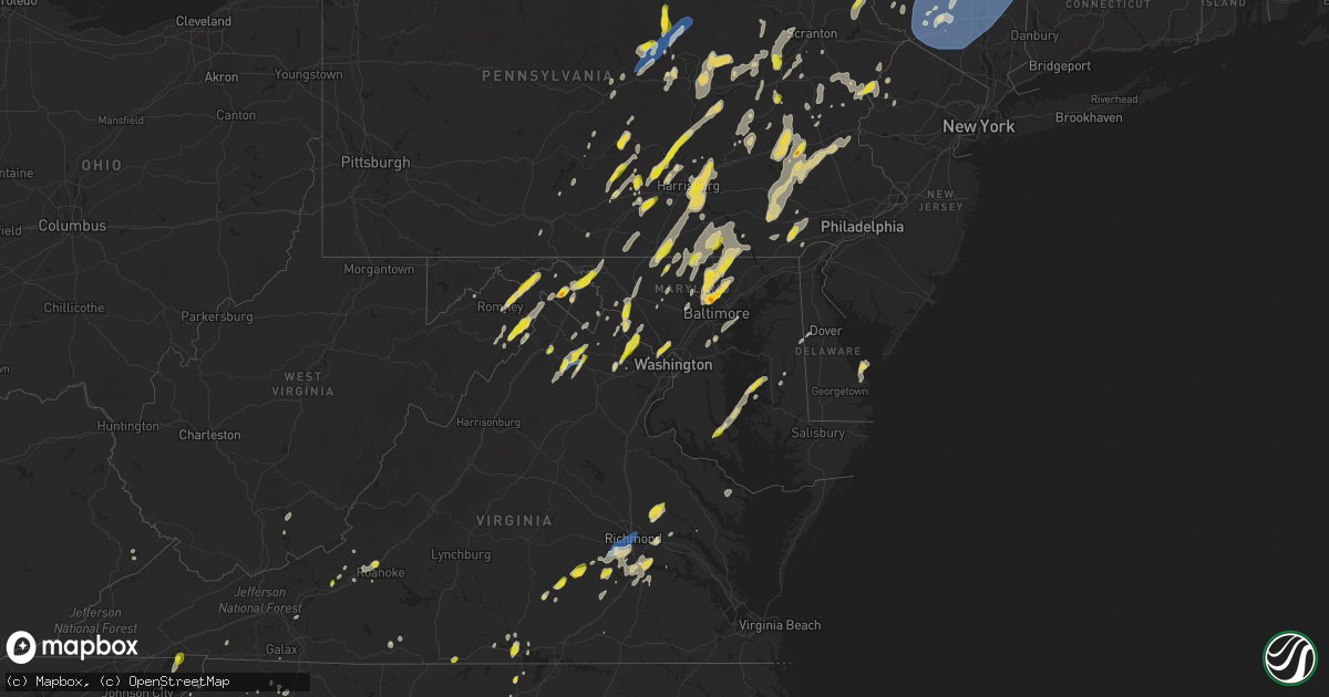
Hail Map on September 7, 2023
Get this storm
September 7 map
$229
one time, instant access
Download today. No call, no setup
Keep the $229
Bought the map and want the full workflow? Apply the entire $229 to a subscription within 7 days. None of it is wasted.
Every map, not just this one
This buys you this map. Subscription and you get every map we run, in the markets you choose from a few cities to whole states to nationwide. Plus real-time alerts the moment a storm fires.
Contact data
Name, contact info, occupancy, even credit band for addresses in the footprint. You go from where it hit to who to call.
Become the source they trust
Unlimited branding weather history reports on demand. You already have the documented answer ready for the property owner, and you are the one who showed up with it.
Property data and RoofTrace estimates
Pull up any address you have got, its value and the exact code rules for that jurisdiction, straight from One Click Code. Then RoofTrace estimates the squares, pitch, and roof value, priced the way you price.
States Impacted by Hail Map on September 7, 2023
Storm reports
Mississippi
| Date | Description |
|---|---|
| 09/07/20236:00 PM CDT | Large tree down along mcnair rd... Near the co line. |
| 09/07/20235:41 PM CDT | Multiple trees down from the stampley area to mcnair. Several down across roads which are now being cleaned up. |
| 09/07/20233:52 PM CDT | Multiple trees were blown down across highway 586. |
| 09/07/20233:29 PM CDT | A tree was blown down and a roof was damaged on new hope church road. |
| 09/07/20233:23 PM CDT | A tree was blown onto highway 587 near racetrack road. |
| 09/07/20233:16 PM CDT | Video relayed by broadcast media showing lots of pea sized hail... With a few bigger around a quarter size. |
| 09/07/20233:15 PM CDT | Power lines down near hwy 49 and turkey creek. |
| 09/07/20233:15 PM CDT | Power lines own near intersection of porter ave and judge sekul ave. |
| 09/07/20233:06 PM CDT | Power lines down near intersection of palmer creek dr and rashell dr. |
Tennessee
| Date | Description |
|---|---|
| 09/07/20233:57 PM CDT | Quarter size hail and a few trees down near shady valley. |
| 09/07/20233:57 PM CDT | Quarter size hail and a few trees down near shady valley. (mr |
West Virginia
| Date | Description |
|---|---|
| 09/07/202312:32 PM CDT | Public estimated hail up to half dollar size near spring mills... Wv. Time estimated from radar. |
| 09/07/202312:28 PM CDT | Public reports quarter sized hail near intersection of berkeley station rd and bedington rd in berkeley... Wv. Time estimated from radar. |
| 09/07/202312:27 PM CDT | Wires were brought down by a downed tree on panorama dr. |
| 09/07/202312:21 PM CDT | Quarter sized hail near back creek south of tomahawk... Wv. Time estimated from radar. |
| 09/07/202312:10 PM CDT | 1 inch hail along back creek valley road. Time estimated from radar. |
| 09/07/202312:10 PM CDT | Public reports hail of at least ping pong ball size east of shanghai along tuscarora pike. Time estimated from radar. |
| 09/07/202312:05 PM CDT | Public reports quarter-sized hail in shanghai. Time estimated from radar. |
| 09/07/202311:10 AM CDT | There were several calls for trees blown down near augusta and frenchburg. |
| 09/07/202311:05 AM CDT | Public reports quarter-sized |
| 09/07/202311:05 AM CDT | Public reports quarter-sized hail near great cacapon. |
| 09/07/202310:50 AM CDT | There were several calls for trees blown down near paw paw. |
| 09/07/202310:49 AM CDT | There were several calls for multiple trees blown down in northeastern hardy county... Including along cr-23/10 trout run road to near the national forest just outside |
| 09/07/202310:14 AM CDT | One tree down due to thunderstorm winds along the 7200 block of jersey mountain road. |
South Dakota
| Date | Description |
|---|---|
| 09/07/202311:32 AM CDT | A local report indicates 1.25 inch wind near 7 SE Hayes |
Missouri
| Date | Description |
|---|---|
| 09/07/20234:31 AM CDT | Report from mping: quarter |
| 09/07/20234:30 AM CDT | A local report indicates 1.00 inch wind near 3 S Seneca |
Pennsylvania
| Date | Description |
|---|---|
| 09/07/20236:12 PM CDT | Wires down on richmond road. Time estimated by radar. |
| 09/07/20235:54 PM CDT | Wires down on south main street of east prospect borough near west ridge avenue. Time estimated by radar. |
| 09/07/20235:50 PM CDT | Trees down. |
| 09/07/20235:45 PM CDT | Trees down. |
| 09/07/20235:24 PM CDT | Downed trees on wires on main rd... Brunner rd... Vera cruz rd... And st peters rd. Time estimated from radar. |
| 09/07/20235:21 PM CDT | Trees and wires down across iron stone hill road in york twp. |
| 09/07/20235:05 PM CDT | Picture of 1 inch hail measured in coatesville. Time estimated. |
| 09/07/20235:00 PM CDT | Corrects previous tstm wnd dmg report from 1 sse stroudsburg. Downed tree in wires on cherry valley road. Time estimated from radar. |
| 09/07/20234:51 PM CDT | Downed tree in wires on cherry valley road. Time estimated from radar. |
| 09/07/20234:50 PM CDT | Downed tree in wires near dreher ave and glen brook road. Time estimated from radar. |
| 09/07/20234:50 PM CDT | Tree down in wires on pa 611 at mount pleasant road from strong outflow winds. Time estimated from radar. |
| 09/07/20234:50 PM CDT | Several reports of downed trees on wires. Roads include business route 209... Hamilton east rd... Brown st... Lower main st... Hamilton south rd... West main st... Sout |
| 09/07/20234:46 PM CDT | Large branches... Trees... And power lines down and burning near river road and harmony station road. Time estimated from radar. |
| 09/07/20234:46 PM CDT | Downed tree limbs and power lines on old carriage road. Time estimated from radar. |
| 09/07/20234:46 PM CDT | Trained spotter measures wind gust of 61mph with anemometer in forks twp associated with gust front. Time estimated. |
| 09/07/20234:46 PM CDT | Trained spotter measured 61 mph wind gust with anemometer associated with gust front. Time estimated. |
| 09/07/20234:45 PM CDT | Large maple tree down. Snapped across trunk. Minor house damage. Telecom wires down. Power lines unaffected. |
| 09/07/20234:43 PM CDT | Tree down in wires at raubsville road and deemer road from strong outflow winds.time estimated from radar. |
| 09/07/20234:42 PM CDT | Picture of a large tree snapped on broad street in tatamy associated with gust front. Time estimated from radar. |
| 09/07/20234:42 PM CDT | Downed tree in wires on hamilton s near saylorsburg. Time estimated from radar. |
| 09/07/20234:40 PM CDT | Large pine tree snapped from strong outflow winds. Time estimated from radar. |
| 09/07/20234:39 PM CDT | Multiple trees and wires down across storms store road in mt. Pleasant twp. |
| 09/07/20234:38 PM CDT | Downed tree branches and power lines at oakhurst drive and old bethlehem pike. Time estimated from radar. |
| 09/07/20234:38 PM CDT | Trees and power lines down on upper smith gap road. Time estimated from radar. |
| 09/07/20234:34 PM CDT | Trees and power lines down on lower smith gap road. Time estimated from radar. |
| 09/07/20234:34 PM CDT | Several reports of large branches and power lines down in north whitehall township. Time estimated from radar. |
| 09/07/20234:34 PM CDT | Corrects previous tstm wnd dmg report from 3 sw fountain hill. Downed tree on wires. Time estimated from radar. |
| 09/07/20234:27 PM CDT | Tree limbs down on wires on vinemont road. Time estimated from radar. |
| 09/07/20234:23 PM CDT | Downed tree on wires at werleys corner road and bake oven road. Time estimated from radar. |
| 09/07/20234:23 PM CDT | Downed tree in wires. Time estimated from radar. |
| 09/07/20234:20 PM CDT | Jcpl reports tree damage resulting in power outages along weisenberg church road. Time estimated from radar. |
| 09/07/20234:15 PM CDT | Tree down with debris in road. |
| 09/07/20234:13 PM CDT | Trees and wires down along lowry road in earl twp. |
| 09/07/20234:13 PM CDT | Wires down on road. |
| 09/07/20234:13 PM CDT | Tree down... Taking wires and utility box with it. |
| 09/07/20234:13 PM CDT | Tree down. |
| 09/07/20234:12 PM CDT | Jcpl reports tree damage resulting in power outages along weisenberg church road near new smithville. Time estimated from radar. |
| 09/07/20234:07 PM CDT | Tree down... Blocking travel lane. |
| 09/07/20234:03 PM CDT | Report from mping: 1-inch tree limbs broken; shingles blown off. |
| 09/07/20234:01 PM CDT | Delayed report... Large tree down partially blocking one lane of penn avenue in wernersville. Time estimated from radar. |
| 09/07/20233:59 PM CDT | *** 1 fatal *** corrects previous tstm wnd dmg report from 1 ne montrose. Tree down on male with injuries. *updated the report as new information verified that the vict |
| 09/07/20233:59 PM CDT | *** 1 inj *** tree down on male with injuries. |
| 09/07/20233:57 PM CDT | Two trees down... Wire across road. |
| 09/07/20233:57 PM CDT | Trees down on wires along manheim pike at the lancaster city line. |
| 09/07/20233:55 PM CDT | Two trees down with wires across road. |
| 09/07/20233:51 PM CDT | Wires down. |
| 09/07/20233:50 PM CDT | Shingles blown off roof. |
| 09/07/20233:44 PM CDT | Trees and wires down along melvin drive. |
| 09/07/20233:40 PM CDT | Multiple trees down on hunter highway. |
| 09/07/20233:38 PM CDT | Tree on wires. |
| 09/07/20233:36 PM CDT | Tree down on house. |
| 09/07/20233:32 PM CDT | Tree down on gravel pond road. |
| 09/07/20233:32 PM CDT | Tree down on grove street. |
| 09/07/20233:30 PM CDT | Trees on wires. |
| 09/07/20233:28 PM CDT | Large tree down blocking the on ramp to route 72. |
| 09/07/20233:27 PM CDT | Multiple trees down. |
| 09/07/20233:25 PM CDT | Trees down blocking swatara drive in east hanover twp. |
| 09/07/20233:20 PM CDT | Trees down. |
| 09/07/20233:19 PM CDT | Trees down with power outages. |
| 09/07/20233:11 PM CDT | Tree down on road. |
| 09/07/20233:10 PM CDT | Tree down on road. |
| 09/07/20233:06 PM CDT | Trees and wires down in highspire. |
| 09/07/20233:05 PM CDT | Trees and wires down. |
| 09/07/20233:01 PM CDT | Tree and power lines down. |
| 09/07/20232:55 PM CDT | Trees and wires down on conewago road in dover twp. |
| 09/07/20232:50 PM CDT | Trees and wires down on rocky road in manheim twp. |
| 09/07/20232:45 PM CDT | Trees down. |
| 09/07/20232:45 PM CDT | Numerous trees down. |
| 09/07/20232:40 PM CDT | Multiple trees and wires down in minersville. |
| 09/07/20232:34 PM CDT | Trees and wires down. |
| 09/07/20232:27 PM CDT | Spotter reports large amounts of tree debris across state route 54. |
| 09/07/20232:25 PM CDT | A local report indicates 1.00 inch wind near Hazleton |
| 09/07/20232:20 PM CDT | Trees and wires down. |
| 09/07/20232:19 PM CDT | Broadcast partner reports 1 inch hail in duncannon. |
| 09/07/20232:05 PM CDT | Numerous trees and wires down north of shermansdale. |
| 09/07/20231:58 PM CDT | Multiple trees and wires down along burnt house road. |
| 09/07/20231:53 PM CDT | Tree down on a car in porter township. |
| 09/07/20231:50 PM CDT | Trees and wires down on route 44. |
| 09/07/20231:33 PM CDT | Powerlines down. |
| 09/07/20231:19 PM CDT | Trees and wires down in hamburg. Time estimated from radar. |
| 09/07/20231:16 PM CDT | Trees and wires just off of hunters valley road. |
| 09/07/20231:04 PM CDT | Multiple trees and power poles down. |
| 09/07/20231:02 PM CDT | Multiple trees down on route 45. |
| 09/07/20231:00 PM CDT | Multiple trees down on route 322. |
| 09/07/202312:50 PM CDT | Widespread large trees down in rothrock state forest. |
| 09/07/202312:40 PM CDT | Picture sent in of quarter-sized hail in new smithville... Pa. Time estimated from radar. |
| 09/07/202312:37 PM CDT | Trees and wires down on pension hollow road. |
| 09/07/202312:25 PM CDT | Trained spotter reports 1.25 inch hail in kutztown. |
| 09/07/202312:21 PM CDT | Trees down on roadway. |
| 09/07/202312:17 PM CDT | Trained spotter reports quarter sized hail with dime size mixing in on kutztown university campus. |
| 09/07/202312:10 PM CDT | Tree down on roadway. |
Massachusetts
| Date | Description |
|---|---|
| 09/06/20238:45 PM CDT | Tree down at intersection of meadow rd and south ferry rd in montague. Relayed by amateur radio. |
| 09/06/20238:40 PM CDT | Tree down on wires on stillwater rd in deerfield. Relayed by amateur radio. |
| 09/06/20238:35 PM CDT | Tree down on west hawley rd in hawley. Relayed by amateur radio. |
| 09/06/20238:30 PM CDT | Tree and wires downed on pond road in rowe. Relayed by amateur radio. |
| 09/06/20238:30 PM CDT | Tree down blocking south river rd in charlemont. Relayed by amateur radio. |
| 09/06/20238:28 PM CDT | Tree down near dickinson hill rd in russell. Relayed by amateur radio. |
| 09/06/20238:20 PM CDT | Tree down on county rd in huntington. Relayed by amateur radio. |
| 09/06/20238:15 PM CDT | Corrects previous tstm wnd dmg report from 3 w worthington. Tree down on powerlines near old north rd in worthington. Relayed by amateur radio. |
| 09/06/20237:51 PM CDT | Trees and large tree branches down at property on church hill street. Large branches on house and multiple trees uprooted. |
| 09/06/20237:51 PM CDT | Tree down on pecks rd. |
| 09/06/20237:50 PM CDT | Tree down on house on lebanon moutain rd. Time estimated from radar. |
| 09/06/20237:50 PM CDT | Tree and wires down on alcove st. |
| 09/06/20237:50 PM CDT | Tree down on house on benedict rd. |
| 09/06/20237:50 PM CDT | Tree and wires down on stoddard ave. |
| 09/06/20237:50 PM CDT | Tree and phone pole down on berkshire ave. |
| 09/06/20237:50 PM CDT | Tree and phone pole down on berkshire ave. |
| 09/06/20237:45 PM CDT | Tree and wires down on gulf rd. |
| 09/06/20237:45 PM CDT | Multiple trees down in road near rt 41 and baker st. |
| 09/06/20237:45 PM CDT | Tree down on house |
| 09/06/20237:34 PM CDT | Tree down along stockbridge rd. |
New Jersey
| Date | Description |
|---|---|
| 09/07/20235:49 PM CDT | Trees down at the intersection of route 23 and route 519. Time estimated from radar. |
| 09/07/20235:45 PM CDT | Received several photos from a trained spotter of several trees down at pleasant acres campground in wantage. Time estimated. |
| 09/07/20235:37 PM CDT | Report of trees down on wires near the byram shoprite. Time estimated from radar. |
| 09/07/20235:32 PM CDT | Report of a tree down blocking a road in whitehall. Time estimated from radar. |
| 09/07/20235:28 PM CDT | Trained spotter reports of wires down on louis ln in hackettstown. |
| 09/07/20235:27 PM CDT | Trained spotter reports 2 trees with wires down on mitchell road in hackettstown. |
| 09/07/20231:42 PM CDT | Pictures sent in of quarter to half dollar sized hail. Time estimated from radar. |
Maine
| Date | Description |
|---|---|
| 09/07/20236:30 PM CDT | Several trees reported down across river road in oakfield. |
| 09/06/20237:50 PM CDT | Tree down across route 201a on the embden -north anson town line. Time estimated by radar. |
| 09/06/20237:50 PM CDT | Trees and powerlines down on fahi pond rd. Time estimated by radar. |
Arkansas
| Date | Description |
|---|---|
| 09/07/20235:52 AM CDT | Downed power lines near the high school. Time estimated using radar. |
Maryland
| Date | Description |
|---|---|
| 09/07/20236:22 PM CDT | Quarter size hail was observed by trained spotters in the 43500 block of drum cliff road near the tidal patuxent river. |
| 09/07/20236:00 PM CDT | Trees and branches blew down and nickel to quarter size hail was observed at fawn view farm on onion |
| 09/07/20236:00 PM CDT | Trees and branches blew down and nickel to quarter size hail was observed at fawn view farm on onion road in pylesville. |
| 09/07/20236:00 PM CDT | Trees and branches blew down and nickel to quarter size hail was observed at fawn view farm on onion road in pylesville. |
| 09/07/20234:47 PM CDT | Dime to quarter size hail was observed by a spotter in the 2400 block of cross section road. |
| 09/07/20234:34 PM CDT | Montgomery county em reports trees and power lines down at 2610th block of newton street in silver spring. |
| 09/07/20234:30 PM CDT | Montgomery county em relays report of downted trees on power lines along 3800th block of denfeld ave in kensington. |
| 09/07/20234:30 PM CDT | Quarter size hail was reported in kensington. |
| 09/07/20234:15 PM CDT | Trees blew down between bynum and bel air... Including near the intersection of high point road and md-23 east-west highway. |
| 09/07/20233:30 PM CDT | Trained spotter reports 1 inch hail in towson. |
| 09/07/20233:30 PM CDT | Trees blew down around white hall and norrisville... Including in the 4500 block of amos road. |
| 09/07/20233:15 PM CDT | Ping pong ball size hail was reported in the mount washington area of baltimore city. |
| 09/07/20232:33 PM CDT | A wind gust of 50 knots |
| 09/07/20232:33 PM CDT | A wind gust of 50 knots |
| 09/07/20232:25 PM CDT | Carroll county public schools had delayed dismissal due to roads closed from fallen trees and wires. |
| 09/07/20232:12 PM CDT | Trees blew down along woodbine road and white rock road. |
| 09/07/20232:00 PM CDT | Trees blew down in northeastern frederick county... Including near woodsboro... Lewistown... And keymar. |
| 09/07/20231:59 PM CDT | Multiple trees down on wheyfield drive. |
| 09/07/20231:45 PM CDT | Trees blew down in central frederick county... Including near frederick... Braddock heights... Ballenger creek... And middletown. |
| 09/07/20231:42 PM CDT | A local report indicates 1.00 inch wind near 3 SW Buckeystown |
| 09/07/20231:40 PM CDT | Trees blew down on southbound i-270 dwight d. Eisenhower highway before exit 18/md-121 stringtown road. |
| 09/07/20231:40 PM CDT | Quarter size hail was reported in adamstown. |
| 09/07/20231:35 PM CDT | Trees and wires blew down on md-27 ridge road at penn shop road. |
| 09/07/20231:35 PM CDT | Trees blew down on md-27 ridge road at penn shop road. |
| 09/07/20231:34 PM CDT | Trees and wires blew down near the intersection of md-28 darnestown road and md-117 bucklodge road. |
| 09/07/20231:28 PM CDT | Trees blew down in southwestern frederick county near rosemont... Brunswick... And knoxville. |
| 09/07/202312:45 PM CDT | Trees blew down on eastbound i-70 dwight d. Eisenhower highway near us-11 virginia avenue. |
| 09/07/202312:45 PM CDT | There were over a dozen calls for trees and wires blown down over central washington county. |
| 09/07/202312:45 PM CDT | Wind-driven quarter size hail and measured wind gusts of over 65 knots |
| 09/07/202312:45 PM CDT | Wind-driven quarter size hail and measured wind gusts of over 65 knots |
| 09/07/202312:45 PM CDT | Trees blew down on eastbound i-70 dwight d. Eisenhower highway near us-11 virginia avenue. Trees blew down on northbound i-81 near i-70 dwight d. Eisenhower highway. |
| 09/07/202310:54 AM CDT | Public estimates quarter-sized hail in paw paw. Time estimated from radar. |
| 09/07/20233:23 AM CDT | Multiple trees down in the severna park area. |
| 09/06/20237:24 PM CDT | County emergency management reports trees and wires down across unionville. Time estimated via radar. |
Vermont
| Date | Description |
|---|---|
| 09/07/20234:23 PM CDT | Tree down into power lines at intersection of scott hill and east road |
| 09/07/20233:30 PM CDT | Trees and power lines down south of rt 101 and rt 242 intersection. |
| 09/07/20232:51 PM CDT | Tree down into powerlines on little river road and tree down in kneeland flats. |
| 09/07/20232:09 PM CDT | A local report indicates 60 MPH wind near 1 SSE Burlington |
| 09/07/20232:07 PM CDT | Trees down on severance road in colchester... Vt |
| 09/06/20239:19 PM CDT | Large tree down in front yard. Power out |
| 09/06/20239:00 PM CDT | Several trees and power lines down across the town. |
Georgia
| Date | Description |
|---|---|
| 09/07/20235:22 PM CDT | Emergency manager reported metal roofing removed from a carport and damage to the roof of a barn on the 1500 block of hwy 358. |
| 09/07/20235:22 PM CDT | Emergency manager reported golf ball sized hail on hwy 358 near woodland rd. |
| 09/07/20235:18 PM CDT | Grady 911 reported numerous trees and powerlines down in cairo. The emergency manager stated that several homes had trees on them. |
| 09/07/20235:18 PM CDT | Grady 911 reports numerous reports of trees and powerlines down in cairo. |
| 09/07/20235:10 PM CDT | Multiple trees down along woodland rd. Damage to roofs and structural supports at two buildings middle ga sports complex. Small building destroyed. Golf ball sized hail |
| 09/07/20235:05 PM CDT | Trained spotter reported quarter sized hail on liberty estates drive. |
| 09/07/20235:00 PM CDT | Shingles off roof... Foam insulation off storage building... Yard chairs etc.. Blown in yard. 1700 block hwy 358. |
| 09/07/20235:00 PM CDT | Damage to residential roof. Partial collapse of barn. Multiple trees down. Powerline/transformer down. 1500 block hwy 358. |
| 09/07/20234:55 PM CDT | Emergency manager reported a tree down near the intersection of bullard rd and marion-ripley rd. |
| 09/07/20234:51 PM CDT | Emergency manager reported a tree down on marion-ripley rd near hwy 80. |
| 09/07/20234:50 PM CDT | Trees down 5500 block bullard rd. |
| 09/07/20234:45 PM CDT | Tree down 2500 block sgoda rd. |
| 09/07/20234:35 PM CDT | Emergency manager reported two trees down on horse shoe rd. |
| 09/07/20234:25 PM CDT | Emergency manager reported a few trees down on riggins mill rd near the ga-87 connector and hwy 80. |
| 09/07/20234:20 PM CDT | Public report of ping pong sized hail near the intersection of langston rd and lake joy rd. |
| 09/07/20234:15 PM CDT | Public reported 1 inch hail on kendall ct. |
| 09/07/20234:04 PM CDT | Multiple reports of quarter sized hail were made in the area of upper river rd near the river north subdivision. |
| 09/07/20233:50 PM CDT | Public report of quarter-sized hail on the 800 block of chester hwy. The hail lasted 6-7 minutes over this location. |
| 09/07/20233:24 PM CDT | Tree and power line down on clarks hill rd |
| 09/07/20233:18 PM CDT | A few trees were downed on round oak juliette rd near the federal wildlife refuge offices. |
| 09/07/20233:18 PM CDT | Multiple trees were downed near the intersection of round oak juliette rd and ga hwy 11. |
| 09/07/20233:00 PM CDT | A tree was downed at rickerson rd and powell rd. Time estimated. |
| 09/07/20232:58 PM CDT | Amateur radio operator forwarded a report of quarter sized hail at old belair rd. Specific location not provided. Time estimated by radar. |
| 09/07/20232:56 PM CDT | Tree and power line down on scotts ferry rd near scotts ferry trail. Time estimated. |
| 09/07/20232:55 PM CDT | A tree was down blocking all westbound lanes of interstate 20 at mile marker 190... Near lewiston rd. |
| 09/07/20232:20 PM CDT | Emergency manager reported a tree down on the roadway on hwy 18 in gordon... Near state spur 18. |
| 09/07/20232:00 PM CDT | Corrects previous tstm wnd dmg report from 1 sw gordon. Emergency manager reported a tree down on the roadway on hwy 18 in gordon... Near state spur 18. |
| 09/07/20231:59 PM CDT | Emergency manager reported a tree down on ridge rd near the intersection with hwy 57. |
| 09/07/20231:58 PM CDT | Emergency manager reported a tree down at the 100 block of westbrook rd. |
| 09/07/20231:55 PM CDT | Emergency manager reported golf ball sized hail large enough to crack a windshield on hwy 49 near hwy 195. |
New Hampshire
| Date | Description |
|---|---|
| 09/07/20234:35 PM CDT | Trees down on forest lane in pittsburg. Time estimated by radar. |
| 09/07/20234:35 PM CDT | Hailstones 0.75 to 1.00 inch observed. |
| 09/07/20234:35 PM CDT | Social media photos of 1 inch hail in clarksville area on old canaan rd. Hail lasted for 6-7 minutes. Time estimated by radar. |
| 09/06/202310:10 PM CDT | Delayed report. Tree down on route 49 near dunkin donuts. Also... 12 inch diameter tree damaged the roof of an equipment shed at a local school. |
| 09/06/20239:43 PM CDT | Delayed report. Social media photos of trees down across haverill. |
| 09/06/20239:30 PM CDT | Delayed report. |
| 09/06/20239:28 PM CDT | Delayed report. |
Virginia
| Date | Description |
|---|---|
| 09/07/20236:59 PM CDT | Large tree limb around 6 inches in diameter and close to 20 feet long across mountain road near h&h grocery. Time estimated from radar. |
| 09/07/20236:50 PM CDT | Tree knocked down on a powerline resulting in power outage. Time estimated from radar. |
| 09/07/20236:45 PM CDT | Report from mping: trees uprooted or snapped. |
| 09/07/20236:40 PM CDT | Several large |
| 09/07/20236:35 PM CDT | Tree knocked down along i-195n. Time estimated from radar. |
| 09/07/20236:34 PM CDT | Report via twitter. Time estimated from radar. |
| 09/07/20236:31 PM CDT | Tree knocked down... Blocking colts neck rd. Time estimated from radar. |
| 09/07/20236:31 PM CDT | 2 trees knocked down. Time estimated from radar. |
| 09/07/20236:30 PM CDT | Report from mping: 3-inch tree limbs broken; power poles broken. |
| 09/07/20236:30 PM CDT | Significant tree damage across the northern portion of the county in particular with multiple trees into houses. In addition... Approximately 200f the county is witho |
| 09/07/20236:25 PM CDT | Quarter sized hail was reported at the virginia international raceway. |
| 09/07/20236:24 PM CDT | A local report indicates 1.00 inch wind near 6 ESE Ringgold |
| 09/07/20236:16 PM CDT | Tree knocked down across the roadway. Time estimated from radar. |
| 09/07/20236:11 PM CDT | Multiple trees uprooted and a tree has been knocked down into a home. Time estimated from radar. |
| 09/07/20236:10 PM CDT | Report from mping: trees uprooted or snapped. |
| 09/07/20236:09 PM CDT | A large tree limb fell into a house in the chesterfield courthouse area. In addition... Hail was estimated to be around 1 inch. Time estimated from radar. |
| 09/07/20235:35 PM CDT | Report via facebook. Time estimated from radar. |
| 09/07/20235:30 PM CDT | Report via social media. Time estimated from radar. |
| 09/07/20235:01 PM CDT | Mutiple videos/pictures of approximately quarter sized hail in and around the town of crewe. Time estimated from radar. |
| 09/07/20234:10 PM CDT | Tree down resulting in power outages. Time estimated from radar. |
| 09/07/20233:50 PM CDT | A local report indicates 1.00 inch wind near 1 W Hollins |
| 09/07/20233:45 PM CDT | Very large tree snapped near base and caused minor damage to an outdoor deck. |
| 09/07/20233:41 PM CDT | Thunderstorm winds blew down a tree into a power line on barnett road nw. |
| 09/07/20233:37 PM CDT | Tree down at intersection of electric road and greenridge road. Time estimated from radar. |
| 09/07/20233:00 PM CDT | At least quarter size hail was observed near brambleton. |
| 09/07/20232:58 PM CDT | A local report indicates 1.00 inch wind near 2 S Upperville |
| 09/07/20232:46 PM CDT | Delaplane fire dept responded to several calls of downed trees and wires. |
| 09/07/20232:45 PM CDT | Downed trees and wires caused a power outage near delaplane. |
| 09/07/20232:44 PM CDT | Thunderstorm winds blew down a tree near the intersection of jennelle road and yellow sulphur road. |
| 09/07/20232:42 PM CDT | A local report indicates 1.00 inch wind near 1 ESE Merrimac |
| 09/07/20232:40 PM CDT | Around a dozen large trees down just south of blacksburg... As well as a power line near the intersection of jennelle road and south main street. Time estimated from ra |
| 09/07/20232:35 PM CDT | Tree was downed by thunderstorm winds and fell onto a power line. |
| 09/07/20232:35 PM CDT | Thunderstorm winds blew down a large tree into the roadway near the intersection of sleepy hollow road and cambria street. |
| 09/07/20231:22 PM CDT | A local report indicates 1.00 inch wind near Countryside |
| 09/07/20231:21 PM CDT | There were a few reports of quarter size hail in the ashburn area. |
| 09/07/20231:10 PM CDT | Trees blew down near waterford... Including on northbound va-704 hamilton station road near va-9 charles town pike. Trees blew down near the intersection of va-704 hami |
| 09/07/20231:10 PM CDT | Quarter size hail was observed at the nws office in sterling. |
| 09/07/20231:10 PM CDT | Trees blew down near waterford... Including on northbound va-704 hamilton station road near va-9 charles town pike. |
| 09/07/202312:21 PM CDT | Trees blew down along va-55 john marshall highway near markham. |
| 09/07/202312:19 PM CDT | There were several calls for trees blown down along va-55 john marshall highway between linden and markham. |
| 09/07/202312:15 PM CDT | There were about half a dozen calls for trees blown down in the linden area. |
| 09/07/202312:10 PM CDT | There were calls for trees blown down in stephens city. |
| 09/07/202312:09 PM CDT | A wind gust of 54 knots |
| 09/07/202312:06 PM CDT | There was a call for a few trees blown down in chester gap. |
| 09/07/202311:59 AM CDT | A wind gust of 50 knots |
| 09/07/202311:35 AM CDT | There were calls for trees blown down in gore. |
| 09/06/202310:16 PM CDT | Several trees were downed by thunderstorm winds in the rocky m |
| 09/06/202310:16 PM CDT | Several trees were downed by thun |
| 09/06/202310:16 PM CDT | Several trees were downed by thunderstorm winds in the rocky mount area. |
| 09/06/202310:15 PM CDT | Trees down at the intersection of barrows mill road and terrys mountain road. Time estimated from radar. |
| 09/06/202310:00 PM CDT | Two trees down across terrys mountain road. |
| 09/06/20239:55 PM CDT | Tree down on craig loop near count pulaski drive. Time estimated from radar. |
| 09/06/20239:26 PM CDT | Powerlines down across philpott drive. |
| 09/06/20239:16 PM CDT | A power line was downed by thunderstorm winds near the intersection of maplewood avenue and henry street. |
| 09/06/20239:00 PM CDT | Tree downed by thunderstorm winds in hillsville. |
| 09/06/20238:57 PM CDT | A few trees were downed by thunderstorm winds in the 2900 block of old route 100 road. |
| 09/06/20237:16 PM CDT | Tree knocked down along old church rd. Time estimated from radar. |
| 09/06/20237:00 PM CDT | Report from mping: trees uprooted or snapped. |
New York
| Date | Description |
|---|---|
| 09/07/20236:58 PM CDT | Tree and wires down on lake nebo road in fort ann about a mile from copeland pond |
| 09/07/20236:50 PM CDT | Rt 22 closed between rt 43 and wyomanock rd due to downed trees and wires in the roadway. Time estimated from radar. |
| 09/07/20236:50 PM CDT | Tree down on wires at old mill street. |
| 09/07/20236:50 PM CDT | Downed tree. Time radar estimated. |
| 09/07/20236:50 PM CDT | Tree down on wires at old mil |
| 09/07/20236:44 PM CDT | Tree on house. Time radar estimated. |
| 09/07/20236:43 PM CDT | Tree and wires burning at 539 route 32. |
| 09/07/20236:41 PM CDT | Wires down at 1224 route 17k. |
| 09/07/20236:38 PM CDT | Trees and wires down. Time radar estimated. |
| 09/07/20236:38 PM CDT | Wires down. Time radar estimated. |
| 09/07/20236:36 PM CDT | Trees and wires down. Time radar estimated. |
| 09/07/20236:32 PM CDT | Tree down at county route 17 and waterbury rd in redfield. |
| 09/07/20236:32 PM CDT | Trees and wires down on mccaw rd in redfield. |
| 09/07/20236:30 PM CDT | Tree and wires down at woodcock mountain road and adelaide lane. |
| 09/07/20236:30 PM CDT | Tree down on house per photo on social media. |
| 09/07/20236:29 PM CDT | Tree down on north jefferson st in pulaski. |
| 09/07/20236:25 PM CDT | Trees and wires down. Time radar estimated. |
| 09/07/20236:23 PM CDT | Tree down on marsh road. |
| 09/07/20236:23 PM CDT | Tree and wires down at 380 bullville road. |
| 09/07/20236:17 PM CDT | A local report indicates 1.00 inch wind near 1 NE Bloomingburg |
| 09/07/20236:14 PM CDT | Wires down and burning on route 211 east between hidden valley drive and goshen turnpike. |
| 09/07/20236:11 PM CDT | Multiple trees and wires down. |
| 09/07/20236:11 PM CDT | Trees and wires down. |
| 09/07/20236:06 PM CDT | Trees down. |
| 09/07/20236:06 PM CDT | Tree down on red schoolhouse rd. |
| 09/07/20236:05 PM CDT | Tree and wires down county route 64. |
| 09/07/20236:05 PM CDT | Tree down with wires burning on sutherland road between county route 61 and dobbin hill road in jackson... Ny |
| 09/07/20236:05 PM CDT | Trees down. |
| 09/07/20236:04 PM CDT | Trees down. |
| 09/07/20236:04 PM CDT | Tree down at state route 3 and beesaw rd. |
| 09/07/20236:04 PM CDT | Trees down. |
| 09/07/20236:04 PM CDT | Wires down near state route 46 and walker road. |
| 09/07/20236:01 PM CDT | Tree down on route 64. |
| 09/07/20235:58 PM CDT | Tree down at state route 49 and canterbury way in hastings. |
| 09/07/20235:58 PM CDT | Corrects report source in previous tstm wnd dmg report from fulton. Tree down on west 4th street in fulton. |
| 09/07/20235:50 PM CDT | Trees down. |
| 09/07/20235:47 PM CDT | Several trees down and a snapped powerline in schodack landing. |
| 09/07/20235:45 PM CDT | Trees and wires down. |
| 09/07/20235:44 PM CDT | Tree down on murphys rd |
| 09/07/20235:34 PM CDT | Trees and wire down. |
| 09/07/20235:30 PM CDT | Trees down. |
| 09/07/20235:30 PM CDT | Trees down. |
| 09/07/20235:25 PM CDT | Trees down. |
| 09/07/20235:25 PM CDT | Trees down near stevens road and grant ave... Relayed by nws buf. |
| 09/07/20235:23 PM CDT | Trees and wires down. |
| 09/07/20235:21 PM CDT | Trees down. |
| 09/07/20235:20 PM CDT | Trees down. |
| 09/07/20235:18 PM CDT | Numerous trees down. |
| 09/07/20235:15 PM CDT | Tree down on road. |
| 09/07/20235:13 PM CDT | Tree down on road. |
| 09/07/20235:13 PM CDT | Tree down on road. |
| 09/07/20235:11 PM CDT | Trees and wires down on wright town road |
| 09/07/20235:10 PM CDT | Tree on house on neilson ave |
| 09/07/20235:09 PM CDT | Wires down on union ave and henning road. |
| 09/07/20235:07 PM CDT | Trees and wires down on gronczniak road. |
| 09/07/20235:05 PM CDT | Tree down on road |
| 09/07/20235:05 PM CDT | Tree down on road. |
| 09/07/20235:05 PM CDT | Wires down on lake road and grace moore road. |
| 09/07/20235:05 PM CDT | Wires down on route 75 and burrello court |
| 09/07/20235:05 PM CDT | Tree down on road. |
| 09/07/20235:05 PM CDT | Trees down. |
| 09/07/20235:02 PM CDT | Trees down. |
| 09/07/20235:01 PM CDT | Received a report of nickel to quarter size inch hail near the malta community center. |
| 09/07/20235:01 PM CDT | Received a report of dime to quarter size inch hail near stillwater. |
| 09/07/20235:00 PM CDT | Tree down blocking the road. Time estimated from radar. |
| 09/07/20234:55 PM CDT | Tree down on road. |
| 09/07/20234:45 PM CDT | Trees down. |
| 09/07/20234:44 PM CDT | Corrects previous tstm wnd dmg report from 1 nw locke. Trees down. |
| 09/07/20234:41 PM CDT | Report of quarter size hail |
| 09/07/20234:40 PM CDT | Corrects previous tstm wnd dmg report from 4 nne groton. Trees down. |
| 09/07/20234:39 PM CDT | Trees down. |
| 09/07/20234:36 PM CDT | Trees down. |
| 09/07/20234:31 PM CDT | Tree and wires down on road. |
| 09/07/20234:30 PM CDT | Trees down. |
| 09/07/20234:28 PM CDT | Tree and wires down on road. |
| 09/07/20234:24 PM CDT | Tree and wires down. |
| 09/07/20234:22 PM CDT | Tree down on route 8 in johnsburg. Time estimated from radar. |
| 09/07/20234:20 PM CDT | Several trees down across road. |
| 09/07/20234:05 PM CDT | Tree down on occupied camper. Unknown injuries. |
| 09/07/20234:03 PM CDT | Tree on powerline near the transfer station in guilderland. |
| 09/07/20233:55 PM CDT | Tree down on the road. |
| 09/07/20233:50 PM CDT | Multiple trees down and power poles snapped. |
| 09/07/20233:45 PM CDT | Tree and wires down. |
| 09/07/20233:45 PM CDT | Tree down on house. Power pole snapped in half. |
| 09/07/20233:45 PM CDT | Multiple trees and wires down. |
| 09/07/20233:40 PM CDT | Multiple trees down around owego. |
| 09/07/20233:38 PM CDT | A couple of trees down in the town of summit near clapper hollow |
| 09/07/20233:06 PM CDT | Tree and wires down. |
| 09/07/20232:41 PM CDT | Multiple trees down. |
| 09/07/20232:41 PM CDT | Multiple trees down. |
| 09/07/20232:36 PM CDT | A local report indicates 1.00 inch wind near Afton |
| 09/07/20231:50 PM CDT | Single tree down on roadway in town. |
| 09/07/202312:43 PM CDT | A local report indicates 1.25 inch wind near Willsboro Point |
| 09/06/20238:44 PM CDT | Trees down. |
| 09/06/20238:40 PM CDT | Trees down. |
| 09/06/20238:30 PM CDT | Tree down on ash grove road between chesnut hill road and mckie hollow road in white creek. |
| 09/06/20238:22 PM CDT | Wires and transformer down on county route 68 between state line road and niles road. |
| 09/06/20238:16 PM CDT | Tree down on wires blocking niles road between meeting house and gannon road in white creek |
| 09/06/20238:16 PM CDT | Tree down. Time radar estimated. |
| 09/06/20238:15 PM CDT | Reports of multiple trees and power lines down in hoosick resulting in numerous power outages. Time estimated from radar. |
| 09/06/20238:14 PM CDT | Tree on wires. Time radar estimated. |
| 09/06/20238:10 PM CDT | Several trees down and a snapped powerline in schodack landing. |
| 09/06/20237:50 PM CDT | Rt 22 closed between rt 43 and wyomanock rd due to downed trees and wires in the roadway. Time estimated from radar. |
| 09/06/20237:49 PM CDT | Wires down on burgoyne road |
| 09/06/20237:45 PM CDT | Tree down on davis ave. |
| 09/06/20237:42 PM CDT | Trees and wires downed on lake nebo road |
| 09/06/20237:39 PM CDT | Road closed due to downed tree on wires. Time radar estimated. |
| 09/06/20237:36 PM CDT | A local report indicates 60 MPH wind near Buckleyville |
| 09/06/20237:31 PM CDT | Tree snapped and came down on wires connected to a residential home. |
| 09/06/20237:30 PM CDT | Time estimated from radar. |
| 09/06/20237:30 PM CDT | A local report indicates 61 MPH wind near Schodack |
| 09/06/20237:29 PM CDT | Downed poles and wires causing all lanes to be closed on ny 9l from county route 27 to pickle hill road |
| 09/06/20237:15 PM CDT | A local report indicates 60 MPH wind near Copake |
| 09/06/20237:11 PM CDT | Tree down blocking hodge rd in the town of watson. |
Kansas
| Date | Description |
|---|---|
| 09/07/20235:15 AM CDT | A local report indicates 1.00 inch wind near Parsons |
| 09/07/20232:57 AM CDT | A local report indicates 1.00 inch wind near 2 NNW Independence |
Delaware
| Date | Description |
|---|---|
| 09/06/20238:16 PM CDT | De state police reports trees down in the area of route 8 blocking the roadway in hartly. Time estimated from radar. |
| 09/06/20238:16 PM CDT | The tops of some trees snapped off. Time estimated from radar. |
Connecticut
| Date | Description |
|---|---|
| 09/06/20237:19 PM CDT | Large tree limbs |
Louisiana
| Date | Description |
|---|---|
| 09/07/20236:48 PM CDT | Power lines down on hwy 55 in bourg. |
| 09/07/20236:36 PM CDT | Metal roof removed on venture blvd. |
| 09/07/20236:28 PM CDT | Tree down in powerlines on shady oaks ct in houma. |
| 09/07/20236:28 PM CDT | Tree down near west park ave and hampton. |
| 09/07/20236:24 PM CDT | Tree down on home on west main st. |
| 09/07/20236:07 PM CDT | Reports |
| 09/07/20236:07 PM CDT | Reports of ping pong ball to golf ball sized hail from 911 center. |
| 09/07/20236:04 PM CDT | Tree down near germany and airline. |
| 09/07/20235:48 PM CDT | Tree down on trailer in hahnville. |
| 09/07/20235:43 PM CDT | A local report indicates 1.00 inch wind near 3 SW Hall Summit |
| 09/07/20235:18 PM CDT | Tree down in the town of saline. |
| 09/07/20234:40 PM CDT | Multiple trees down from the log cabin community to the n side of bastrop. One home had the garage door blown in and damaged the car inside. |
| 09/07/20234:30 PM CDT | A tin roof was peeled off of a manufactured home and a tree was blown onto a house. |
| 09/07/20234:16 PM CDT | Broadcast media relayed pictures of trees down in the bedico area. |
| 09/07/20234:00 PM CDT | Tree down on hwy. 1077 and multiple reports of damage in the spring lakes subdivision including a downed fence... A large outdoor playground destroyed and multiple tree |
| 09/07/20234:00 PM CDT | Trees down and a section of power line down from the trees. |
| 09/07/20233:21 PM CDT | 1-inch tree limbs broken; minor roof damage with some shingles blown off. |
| 09/06/20238:04 PM CDT | Reports of property damage and power outages. |
| 09/06/20237:47 PM CDT | Reports of trees down... Damaged tin roofs... And of a fireplace stack that was knocked down in grand prairie. |
| 09/06/20237:38 PM CDT | Reports of trees down in leonville. |
North Carolina
| Date | Description |
|---|---|
| 09/07/20236:45 PM CDT | Trees down at rhodhiss rd and knob ave. |
| 09/07/20236:05 PM CDT | Trees and limbs down on power lines. |
| 09/07/20235:52 PM CDT | Time estimated from radar. |
| 09/07/20235:50 PM CDT | Time estimated from radar. |
| 09/07/20235:32 PM CDT | A few trees and power lines down in franklin. |
| 09/07/20235:24 PM CDT | Image of 1 inch hail on social media. |
| 09/07/20235:19 PM CDT | Trees and limbs down on power lines. |
| 09/07/20234:15 PM CDT | Quarter-sized hail reported along gela road. |
| 09/07/20231:35 PM CDT | County 911 reports trees down at hwy 191 and n. Rugby rd. |
| 09/06/20238:44 PM CDT | Tree downed by thunderstorm winds along us 421 near the wilkes/watauga county line. |
| 09/06/20238:44 PM CDT | Tree downed by thunderstorm winds on us 421 near the wilkes/watauga county border. |
| 09/06/20238:35 PM CDT | Several trees down around mount airy and ararat... Concentrated near siloam road. Time estimated from radar. |
| 09/06/20238:12 PM CDT | Few trees down on poplar springs road near intersection with highway 21. Time estimated from radar. |
| 09/06/20237:40 PM CDT | One tree was reported down in the richfield area. Time estimated by radar. |
| 09/06/20237:20 PM CDT | Several trees were downed by thunderstorm winds near the intersection of shingle gap road and charity church road near lovette homes. |
| 09/06/20237:20 PM CDT | Tree down near intersection of nc hwy 73 and walker rd. |
| 09/06/20237:10 PM CDT | A couple of trees blown down along horton road. Time was estimated by radar. |
Nebraska
| Date | Description |
|---|---|
| 09/07/20236:00 PM CDT | Driving rain and high winds... Estimated around 60 mph. Small hail. |
| 09/07/20235:25 PM CDT | Multiple tree branches downed and trampoline destroyed. Gusts estimated to be at least 60 mph. |
| 09/07/20235:15 PM CDT | Lots of small hail. Winds estimated to be at least 60 mph. |
| 09/06/20239:44 PM CDT | Nebraska mesonet station. |
| 09/06/20239:44 PM CDT | Valley county dispatch confirms brief very strong wind in town but no damage known at this time. |
| 09/06/20237:50 PM CDT | Quarter to half dollar sized... A lot of nickels. |
South Carolina
| Date | Description |
|---|---|
| 09/07/20236:20 PM CDT | Emergency management report of trees down on pleasant plains road and mustardseed road. Time estimated. |
| 09/07/20236:07 PM CDT | Lancaster county dispatch reported a tree down at pleasant rd and rocky river rd. Time estimated based on radar. |
| 09/07/20236:07 PM CDT | Emergency management reported trees down in kershaw on marion street and north matson street. Time estimated. |
| 09/07/20235:55 PM CDT | Emergency management reported trees down in the 3000 block of green road. Time estimated. |
| 09/07/20235:53 PM CDT | Lancaster county dispatch reported trees down at riverside rd and university dr. Time estimated base on radar. |
| 09/07/20235:53 PM CDT | Kershaw county dispatch reported a tree down at old statescoach rd and winchester road. Time estimated based on radar. |
| 09/07/20235:33 PM CDT | Tree down near intersection of sandy ford rd and parris bridge rd. |
| 09/07/20235:30 PM CDT | A local report indicates 1.75 inch wind near 1 E Boiling Springs Sc |
| 09/07/20235:26 PM CDT | Kershaw county dispatch reported a tree down at wildwood lane and rabon circle. Time estimated based on radar. |
| 09/07/20235:23 PM CDT | A local report indicates 60 MPH wind near 1 E Boiling Springs Sc |
| 09/07/20235:18 PM CDT | Tree down near intersection of fairfield rd and henderson rd. |
| 09/07/20235:18 PM CDT | Tree across roadway near intersection of berry rd and kimbrell oaks dr. |
| 09/07/20235:02 PM CDT | Richland county em reported roadway blocked by downed power lines at the 4100 block of kilbourne rd. Time estimated by radar. |
| 09/07/20234:59 PM CDT | Sc dot reports 4 or 5 trees down on hughey ferry rd near pomaria. Time estimated from radar. |
| 09/07/20234:58 PM CDT | Newberry county reported a tree down along ringer rd. Time estimated based on radar. |
| 09/07/20234:55 PM CDT | Report from person driving through town of nickel to quarter sized hail. Wind was strong but no signs of damage. |
| 09/07/20234:55 PM CDT | Lexington county em reported downed power lines on c ave. Near the intersection of 6th st. Time estimated by radar. |
| 09/07/20234:55 PM CDT | Public reported quarter sized hail. Time estimated based on radar. |
| 09/07/20234:50 PM CDT | Lexington county em reported downed power lines on the 800 block of pond dr. Time estimated by radar. |
| 09/07/20234:50 PM CDT | Lexington county em reported downed trees on dreher rd. Specific location not provided. Time estimated by radar. |
| 09/07/20234:50 PM CDT | Lexington county em reported downed trees on the 200 block of hulon greene pl. Time estimated by radar. |
| 09/07/20234:50 PM CDT | Report from person driving through town of nickel to quarter sized hail. Wind was strong but no signs of damage. |
| 09/07/20234:50 PM CDT | Corrects previous tstm wnd dmg report from 1 sw saint andrews. Richland county em reported roadway blocked by downed power lines at the intersection of browning rd. And |
| 09/07/20234:45 PM CDT | Lexington county em reported downed trees on wescott rd. Near the intersection of greenpines rd. Time estimated by radar. |
| 09/07/20234:45 PM CDT | Tree down on nursery rd and windsong trail. Time estimated. |
| 09/07/20234:45 PM CDT | Tree down on milner rd in little mountain. Time estimated. |
| 09/07/20234:45 PM CDT | Lexington county em reported downed trees on foxfire dr. Near the pine grove apartments. Time estimated by radar. |
| 09/07/20234:45 PM CDT | Lexington county em reported downed power lines on jessamine rd. Near the intersection of orangeburg dr. Time estimated by radar. |
| 09/07/20234:45 PM CDT | Lexington county em reported downed power lines on the 100 block of thames valley ct. Time estimated by radar. |
| 09/07/20234:44 PM CDT | Lexington county em reported downed power lines on partridge ln. Near the intersection of collumwood cir. Time estimated by radar. |
| 09/07/20234:42 PM CDT | Trained spotter reported a tree limb down on a power line at the intersection of sunset blvd. And whiteford way via social media. Time estimated by radar. |
| 09/07/20234:41 PM CDT | Tree down on sam koon rd and maple hallow ln. Time estimated. |
| 09/07/20234:40 PM CDT | Lexington county em reported tree blocking lanes on burton rd. Near i-20. Specific location not provided. Time estimated by radar. |
| 09/07/20234:40 PM CDT | Lexington county em reported downed trees on n. Lake dr. Near the intersection of e. Butler st. Time estimated by radar. |
| 09/07/20234:38 PM CDT | Lexington county em reported downed trees on cedar crest dr. Near the intersection of freedom dr. Time estimated by radar. |
| 09/07/20234:38 PM CDT | Lexington county em reported downed power lines on the 1300 block of n. Lake dr. Time estimated by radar. |
| 09/07/20234:38 PM CDT | Lexington county em reported multiple trees down on old chapin rd. In lexington. Specific locations not provided. Time estimated by radar. |
| 09/07/20234:36 PM CDT | Trained spotter reported large branches down at the 600 block of shore rd. Via social media. Time estimated by radar. |
| 09/07/20234:36 PM CDT | Trained spotter reported tree down on shore rd. Via social media. Time estimated by radar. |
| 09/07/20234:36 PM CDT | Lexington county em reported downed trees at the intersection of columbia ave. And i-26. Time estimated by radar. |
| 09/07/20234:30 PM CDT | Lexington county em reported downed trees on shull island rd. Near the intersection of garden grove cir. Time estimated by radar. |
| 09/07/20234:30 PM CDT | Lexington county em reported downed trees which caused significant damage to a residence on the 300 block of smallwood dr. Time estimated by radar. |
| 09/07/20234:30 PM CDT | Lexington county em reported downed trees on the 700 block of ansel crapps rd. Time estimated by radar. |
| 09/07/20234:30 PM CDT | Trained spotter reported large branches down on calks ferry rd. Via social media. Time estimated by radar. |
| 09/07/20234:29 PM CDT | Lexington county em reported downed trees on the 200 block of bishop gate rd. Time estimated by radar. |
| 09/07/20234:28 PM CDT | Lexington county em reported downed power lines on the 300 block of lewie rd. Time estimated by radar. |
| 09/07/20234:28 PM CDT | Lexington county em reported downed power lines on windmill rd. Near the intersection of lewie rd. Time estimated by radar. |
| 09/07/20234:27 PM CDT | Lexington county em reported downed trees on augusta hwy. Near the intersection of calks ferry rd. Time estimated by radar. |
| 09/07/20234:26 PM CDT | Lexington county em reported downed trees and power lines on lost branch rd. Near the intersection of jeter rd. Time estimated by radar. |
| 09/07/20234:26 PM CDT | Lexington county em reported downed trees on the 1100 block of calks ferry rd. Time estimated by radar. |
| 09/07/20234:26 PM CDT | Dime to quarter sized hail near intersection of turkey farm rd and parris rd. |
| 09/07/20234:22 PM CDT | Saluda county dispatch reported trees down at hollywood rd and prince hill rd. Time estimated based on radar. |
| 09/07/20234:20 PM CDT | Richland county em reported roadway blocked by downed power lines at the intersection of browning rd. And burning tree dr. Time estimated by radar. |
| 09/07/20234:14 PM CDT | Sc dot reports trees down on belfast rd north of silverstreet... Sc. Time estimated from radar. |
| 09/07/20234:14 PM CDT | Sc dot reported trees down on st lukes church road. Time estimated from radar. |
| 09/07/20234:09 PM CDT | Saluda county dispatch reported trees down on fletcher rd. Time estimated based on radar. |
| 09/07/20234:08 PM CDT | Saluda county dispatch reported trees down along brushy fork rd. Time estimated based on radar. |
| 09/07/20234:05 PM CDT | Saluda county dispatch reported trees down at the intersection of rock hill rd and mine creek rd. Time estimated based on radar. |
| 09/07/20234:00 PM CDT | Numerous trees and power lines were downed across the county. |
| 09/07/20233:55 PM CDT | Saluda county dispatch reported trees down at driftwood lane. Time estimated based on radar. |
| 09/07/20233:55 PM CDT | Schp reported tree down on asbury rd near cokesbury rd |
| 09/07/20233:55 PM CDT | Quarter size hail reported on hwy 121 between newberry and saluda. Exact location not provided. Location estimated based on radar. |
| 09/07/20233:50 PM CDT | Tree down on ira kinard rd. Exact location not given. Time estimated. |
| 09/07/20233:46 PM CDT | Tree down near pine pleasant church on old cherokee trail... Between old saluda rd and kempson bridge rd. Time estimated. |
| 09/07/20233:38 PM CDT | Broadcast media relayed a video of hail falling at a residence near the intersection of key rd. And hwy 23. Largest stones are estimated to be quarter sized based on vi |
| 09/07/20233:38 PM CDT | Trees and limbs down on power lines. |
| 09/07/20233:34 PM CDT | Trees and limbs down on power lines. |
| 09/07/20233:34 PM CDT | Trees and tree limbs down on power lines. |
| 09/07/20233:30 PM CDT | Tree down at w martintown rd and currytown rd. Hail of unknown size also reported. Time estimated. |
| 09/07/20233:25 PM CDT | Tree down across humbert rd. Time estimated from radar. |
| 09/07/20233:20 PM CDT | Tree down at bell field rd and bradley rd. Time estimated. |
| 09/07/20233:11 PM CDT | Tree down on a power line at 4200 hwy 28 n... Near wideman cemetery rd. Time estimated. |
| 09/07/20232:43 PM CDT | Also a few tree limbs down. |
| 09/06/20237:35 PM CDT | Tree down near intersection of ridge rd and north little river rd. |
Florida
| Date | Description |
|---|---|
| 09/07/20236:45 PM CDT | Leon county dispatch reports a power line down on windy pine way. |
| 09/07/20236:35 PM CDT | Leon county dispatch reports a tree fell on a power line on osceola st at main st. |
| 09/07/20236:32 PM CDT | Midway fire department reports a tree fell on a car on dupont rd north of midway. |
| 09/07/20236:27 PM CDT | Leon county dispatch reports a tree fell on a car on truett dr. |
| 09/07/20236:27 PM CDT | Leon county dispatch reports a tree fell on a power line on pennlyn dr. |
| 09/07/20236:27 PM CDT | Leon county dispatch reports a tree blocking all lanes of traffic on governors square blvd at blair stone rd. |
| 09/07/20236:27 PM CDT | Leon county dispatch reports a power line down on john knox rd at meridian rd. |
| 09/07/20236:27 PM CDT | Leon county dispatch reports a tree down on n gadsden st at beard st. |
| 09/07/20236:27 PM CDT | Leon county dispatch reports a tree down on richview park circle. |
| 09/07/20236:27 PM CDT | Leon county dispatch reports a power line down and on fire in betton hills. |
| 09/07/20236:27 PM CDT | Emergency management reports a tree on a house on nugent dr. |
| 09/07/20236:27 PM CDT | Leon county dispatch reports a tree on a power line on spottswood dr. |
| 09/07/20234:32 PM CDT | Duke energy reports power outages caused by fallen trees. |
| 09/06/20237:30 PM CDT | 911 dispatch reports a tree on a house. |
| 09/06/20237:30 PM CDT | 911 dispatch reports a tree on a house. Damage photos from this region support 85-90 mph straight-line wind gusts. |
| 09/06/20237:20 PM CDT | Wakulla county dispatch reports a tree down on spring creek hwy at i k porter rd. |
| 09/06/20237:20 PM CDT | Wakulla county dispatch reports a tree down on jack crum rd at santa emma ln. |
| 09/06/20237:12 PM CDT | Wakulla county dispatch reports a power line down on shadeville rd near gala ct. |
| 09/06/20237:12 PM CDT | Wakulla county dispatch reports a power line down on shadeville rd near andrew j hargrett sr rd. |
| 09/06/20237:12 PM CDT | Tree down on shadeville road in crawfordville florida. |
Cities Impacted by Hail Map on September 7, 2023
- Romney, WV
- Fort Pierre, SD
- Landisburg, PA
- Newville, PA
- Kutztown, PA
- Fleetwood, PA
- Front Royal, VA
- Linden, VA
- Markham, VA
- Delaplane, VA
- Martinsburg, WV
- Falling Waters, WV
- Hedgesville, WV
- Williamsport, MD
- Upperville, VA
- Paris, VA
- Shermans Dale, PA
- New Bloomfield, PA
- Mifflin, PA
- Mifflintown, PA
- Millerstown, PA
- Newport, PA
- Port Royal, PA
- Lewistown, PA
- East Waterford, PA
- Blain, PA
- Duncannon, PA
- Pierre, SD
- Gerrardstown, WV
- Inwood, WV
- Chidester, AR
- Berkeley Springs, WV
- Middletown, VA
- Strasburg, VA
- High View, WV
- Yellow Spring, WV
- Camden, AR
- Hampton, AR
- Wardensville, WV
- Capon Bridge, WV
- Mapleton Depot, PA
- Cassville, PA
- Chester Gap, VA
- Huntly, VA
- Gore, VA
- Cross Junction, VA
- Winchester, VA
- Hayes, SD
- Bloomery, WV
- Great Cacapon, WV
- Oldtown, MD
- Slanesville, WV
- Augusta, WV
- Paw Paw, WV
- Points, WV
- Monticello, GA
- Todd, NC
- Willsboro, NY
- Dudley, PA
- Broad Top, PA
- Bentonville, VA
- Stephens City, VA
- Levels, WV
- Shanks, WV
- Star Tannery, VA
- Honesdale, PA
- Honey Grove, PA
- Ickesburg, PA
- Breinigsville, PA
- New Tripoli, PA
- Liverpool, PA
- Sterling, VA
- Chantilly, VA
- Ashburn, VA
- Milanville, PA
- Tyler Hill, PA
- Millersburg, PA
- Poolesville, MD
- Adamstown, MD
- Point Of Rocks, MD
- Tuscarora, MD
- Dalmatia, PA
- Frederick, MD
- Kempton, PA
- Stroudsburg, PA
- Columbia, NJ
- Lock Haven, PA
- Avis, PA
- Jersey Shore, PA
- Linden, PA
- Trout Run, PA
- Roaring Branch, PA
- Liberty, PA
- Waterville, PA
- East Stroudsburg, PA
- Carlisle, PA
- Mount Holly Springs, PA
- Cogan Station, PA
- Hanover, PA
- Littlestown, PA
- Gettysburg, PA
- Grantville, PA
- Annville, PA
- Keeseville, NY
- Colchester, VT
- Burlington, VT
- Winooski, VT
- Ralston, PA
- Mcadoo, PA
- Hazleton, PA
- Tresckow, PA
- Harrisburg, PA
- Middletown, PA
- Hummelstown, PA
- New Oxford, PA
- Cambridge, VT
- Jeffersonville, VT
- Waterville, VT
- Johnson, VT
- Walton, NY
- Hyde Park, VT
- Morrisville, VT
- Diberville, MS
- Biloxi, MS
- Cockeysville, MD
- Reisterstown, MD
- Sparks Glencoe, MD
- Monkton, MD
- Parkton, MD
- Crawfordville, GA
- Washington, GA
- White Hall, MD
- Towson, MD
- Lutherville Timonium, MD
- Baltimore, MD
- Pikesville, MD
- Gibson, GA
- Avera, GA
- Gulfport, MS
- Pass Christian, MS
- Long Beach, MS
- Waterloo, SC
- Greenwood, SC
- Cross Hill, SC
- Glen Arm, MD
- Phoenix, MD
- Foxworth, MS
- Bristol, TN
- Abingdon, VA
- Shady Valley, TN
- Eastman, GA
- Oxford, NC
- Clarksville, VA
- Buffalo Junction, VA
- Silverstreet, SC
- Newberry, SC
- Stewartstown, PA
- New Freedom, PA
- Felton, PA
- Red Lion, PA
- Glen Rock, PA
- Bethesda, MD
- Kensington, MD
- Garrett Park, MD
- Silver Spring, MD
- Rockville, MD
- Manchester, MD
- Leesville, SC
- Gilbert, SC
- Lexington, SC
- Chapin, SC
- Prosperity, SC
- Afton, NY
- Bainbridge, NY
- Sidney, NY
- Unadilla, NY
- Perry, GA
- Nanticoke, PA
- Wilkes Barre, PA
- Mountain Top, PA
- Wapwallopen, PA
- Marathon, NY
- Plymouth, PA
- Cincinnatus, NY
- McGraw, NY
- McDonough, NY
- Willet, NY
- Smithville Flats, NY
- Schenectady, NY
- Rexford, NY
- Ballston Lake, NY
- Clifton Park, NY
- Oxford, NY
- Greene, NY
- Ballston Spa, NY
- Mechanicville, NY
- Saratoga Springs, NY
- Stillwater, NY
- South Plymouth, NY
- Union Bridge, MD
- Westminster, MD
- Taneytown, MD
- Norwich, NY
- Pitcher, NY
- De Ruyter, NY
- Mount Upton, NY
- Guilford, NY
- Madison, NY
- Oriskany Falls, NY
- Sidney Center, NY
- South New Berlin, NY
- Rock Hill, SC
- South Otselic, NY
- North Pitcher, NY
- Franklin, NY
- Otego, NY
- Gilbertsville, NY
- Wells Bridge, NY
- Smyrna, NY
- Plymouth, NY
- Georgetown, NY
- Earlville, NY
- Sherburne, NY
- New Berlin, NY
- Deansboro, NY
- Morris, NY
- Oneonta, NY
- West Oneonta, NY
- Laurens, NY
- Macon, GA
- Mount Vision, NY
- New Lisbon, NY
- Hamilton, NY
- Hubbardsville, NY
- Edmeston, NY
- West Edmeston, NY
- Hartwick, NY
- West Burlington, NY
- Garrattsville, NY
- Burlington Flats, NY
- Columbia, SC
- Milford, NY
- West Columbia, SC
- Maryland, NY
- Portlandville, NY
- Irmo, SC
- Waterville, NY
- Cooperstown, NY
- Rushville, NE
- Gordon, NE
- Merriman, NE
- Blythewood, SC
- Coatesville, PA
- West Grove, PA
- Cochranville, PA
- Roanoke, VA
- Jarrettsville, MD
- Street, MD
- Pylesville, MD
- Oberlin, LA
- Kinder, LA
- Boyce, LA
- Thompson, PA
- Herrick Center, PA
- New Philadelphia, PA
- Tamaqua, PA
- Harpursville, NY
- Regina, KY
- Hume, VA
- Wellsboro, PA
- Honea Path, SC
- Petersburg, PA
- Huntingdon, PA
- Pine Grove, PA
- Kennebec, SD
- Chester, SC
- Carlisle, SC
- Canadian, TX
- Arnett, OK
- McClure, PA
- Ware Shoals, SC
- Williamsport, PA
- Keyser, WV
- Gordon, GA
- Sibley, LA
- Wells, NY
- Pensacola, FL
- Cantonment, FL
- Saint Thomas, PA
- Fort Loudon, PA
- Mercersburg, PA
- Halifax, PA
- Burke, SD
- Platte, SD
- Trade, TN
- Zionville, NC
- Camilla, GA
- Baconton, GA
- Ninety Six, SC
- La Fayette, NY
- Tully, NY
- Apulia Station, NY
- Columbia, MS
- Kokomo, MS
- Cabin John, MD
- Jeffersonville, GA
- Dry Branch, GA
- Saucier, MS
- Preble, NY
- Homer, NY
- Moravia, NY
- Gray, GA
- Oakfield, GA
- White Plains, GA
- Greensboro, GA
- Schuylkill Haven, PA
- Cressona, PA
- Pottsville, PA
- Newburg, PA
- Downsville, NY
- Covington, LA
- Folsom, LA
- Loranger, LA
- Ponchatoula, LA
- Madisonville, LA
- Hagerstown, MD
- Union Dale, PA
- Wrightsville, GA
- Saluda, SC
- Chappells, SC
- Dry Run, PA
- Spring Run, PA
- Doylesburg, PA
- Harrisonburg, LA
- Sicily Island, LA
- Jonesville, LA
- Milroy, PA
- Allenwood, PA
- East Dublin, GA
- Ringtown, PA
- Girardville, PA
- Shenandoah, PA
- Mahanoy Plane, PA
- Ashland, PA
- Frackville, PA
- Branchdale, PA
- Tremont, PA
- Minersville, PA
- Shrewsbury, PA
- Ferrisburgh, VT
- Elliottsburg, PA
- Trevorton, PA
- Elysburg, PA
- Paxinos, PA
- Shamokin, PA
- Coal Township, PA
- Sunbury, PA
- Dornsife, PA
- Danville, PA
- Catawissa, PA
- Herndon, PA
- Damascus, PA
- Equinunk, PA
- Abbeville, GA
- Rochelle, GA
- Bronwood, GA
- Dawson, GA
- Leesburg, GA
- Milton, PA
- Turbotville, PA
- Watsontown, PA
- Shelburne, VT
- Charlotte, VT
- Essex, NY
- Westport, NY
- Raccoon, KY
- Phyllis, KY
- Oacoma, SD
- Swainsboro, GA
- Adrian, GA
- Dubberly, LA
- Columbia, LA
- Horse Shoe, NC
- Hendersonville, NC
- Evans, GA
- Appling, GA
- Clarks Hill, SC
- Loysville, PA
- Montrose, PA
- Heflin, LA
- Hodges, SC
- Perkinston, MS
- Pelham, GA
- Whigham, GA
- Gainesville, VA
- Haymarket, VA
- Catharpin, VA
- Dickerson, MD
- Jefferson, MD
- Leesburg, VA
- Dublin, GA
- Salem, VA
- Tylertown, MS
- Dauphin, PA
- Port Henry, NY
- Moriah, NY
- Crown Point, NY
- Boyce, VA
- Berryville, VA
- Leary, GA
- Byron, GA
- Batesland, SD
- Pine Ridge, SD
- Juliette, GA
- McIntyre, GA
- Huttig, AR
- Inverness, FL
- Fallston, MD
- Gwynn Oak, MD
- Hydes, MD
- New Park, PA
- Stevenson, MD
- Baldwin, MD
- Owings Mills, MD
- Fawn Grove, PA
- Forest Hill, MD
- Bloomsburg, PA
- Orangeville, PA
- Spring Grove, PA
- Lewisberry, PA
- Etters, PA
- York Haven, PA
- New Cumberland, PA
- Dover, PA
- Soperton, GA
- Hamburg, PA
- Shoemakersville, PA
- Lenhartsville, PA
- Jacksonville, GA
- Lumber City, GA
- Modoc, SC
- Eatonton, GA
- Airville, PA
- Brogue, PA
- Edgefield, SC
- Beech Creek, PA
- Mill Hall, PA
- Sandersville, GA
- Warthen, GA
- Sparta, GA
- Bloomville, NY
- Vergennes, VT
- Climax, GA
- Cairo, GA
- Christiansburg, VA
- New Holland, PA
- Gordonville, PA
- Kinzers, PA
- Paradise, PA
- Franklinton, LA
- Angie, LA
- Princeton, LA
- Haughton, LA
- Palmyra, PA
- York, PA
- Highspire, PA
- Hershey, PA
- Manchester, PA
- Delancey, NY
- Mehoopany, PA
- Brackney, PA
- Dillsburg, PA
- Boiling Springs, PA
- Mechanicsburg, PA
- Mitchell, GA
- Grovetown, GA
- Augusta, GA
- Cadwell, GA
- McRae Helena, GA
- Monticello, FL
- Trenton, SC
- Falls, PA
- Pittston, PA
- Dallas, PA
- Amberson, PA
- Friendsville, PA
- East Earl, PA
- Gap, PA
- Blacksburg, VA
- Shickshinny, PA
- Marrero, LA
- New Orleans, LA
- Westwego, LA
- Narvon, PA
- Millville, PA
- Lairdsville, PA
- Hughesville, PA
- Muncy, PA
- Northumberland, PA
- Benton, PA
- Unityville, PA
- Bastrop, LA
- Fabius, NY
- Port Crane, NY
- Binghamton, NY
- Aldie, VA
- Barren Springs, VA
- Hiwassee, VA
- Hillsville, VA
- Freeland, MD
- Hampstead, MD
- Rentz, GA
- Hawkinsville, GA
- Kathleen, GA
- Virgilina, VA
- South Boston, VA
- North Augusta, SC
- Graniteville, SC
- Cochran, GA
- Abbottstown, PA
- East Berlin, PA
- Picayune, MS
- Kiln, MS
- Bradley, SC
- McCormick, SC
- Troy, SC
- Mohrsville, PA
- Hillsboro, GA
- Poplarville, MS
- Diamondhead, MS
- Jamestown, LA
- Jersey, AR
- Everett, PA
- Clearville, PA
- Albrightsville, PA
- Glenwood, GA
- Alamo, GA
- East Branch, NY
- Abbeville, SC
- Defuniak Springs, FL
- Orange Beach, AL
- Elberta, AL
- Lillian, AL
- Union Point, GA
- Scottsburg, VA
- Red Oak, VA
- Toomsboro, GA
- Tennille, GA
- Milledgeville, GA
- Leesport, PA
- Paeonian Springs, VA
- Long Eddy, NY
- Hankins, NY
- Chauncey, GA
- Moss Point, MS
- Grand Bay, AL
- Kite, GA
- Mifflinburg, PA
- New Columbia, PA
- Lewisburg, PA
- Montgomery, PA
- Wellsville, PA
- Knoxville, MD
- Carriere, MS
- New Windsor, MD
- Mount Airy, MD
- Sharon, SC
- McConnells, SC
- York, SC
- Howard, PA
- Bellefonte, PA
- Troutdale, VA
- Reading, PA
- Birdsboro, PA
- Fort Valley, GA
- Biglerville, PA
- Fayetteville, PA
- Orrtanna, PA
- Waynesboro, PA
- Altamont, NY
- Reynolds, GA
- Tallahassee, FL
- Summit Point, WV
- Charles Town, WV
- Quincy, FL
- Attapulgus, GA
- Bainbridge, GA
- Adel, GA
- Sparks, GA
- Eros, LA
- Coushatta, LA
- Clover, SC
- Hamden, NY
- Hawley, PA
- Roscoe, NY
- Beach Lake, PA
- Harlem, GA
- Bangor, PA
- Batesburg, SC
- Monetta, SC
- Lovettsville, VA
- Danville, GA
- Watkinsville, GA
- Roseland, LA
- Amite, LA
- Vilas, NC
- Marysville, PA
- Enola, PA
- Stevensville, PA
- Wyalusing, PA
- Laceyville, PA
- Lawton, PA
- Conklin, NY
- La Place, LA
- Sandy Hook, MS
- Robert, LA
- Bush, LA
- Hammond, LA
- Bogalusa, LA
- Bay Saint Louis, MS
- Shippensburg, PA
- Hunlock Creek, PA
- Bienville, LA
- Castor, LA
- Swiftwater, PA
- Henryville, PA
- Scotrun, PA
- Cresco, PA
- Rockledge, GA
- Tarrytown, GA
- Mount Vernon, GA
- Andreas, PA
- New Ringgold, PA
- Bernville, PA
- Lincolnton, GA
- Gardners, PA
- Roberta, GA
- Zion Grove, PA
- Rock Glen, PA
- Sugarloaf, PA
- Nescopeck, PA
- Thurmont, MD
- Woodsboro, MD
- Walkersville, MD
- Railroad, PA
- Seven Valleys, PA
- Dallastown, PA
- McLean, VA
- Marksville, LA
- Milton, FL
- McHenry, MS
- Centreville, VA
- Keymar, MD
- Thomasville, PA
- McSherrystown, PA
- Camp Hill, PA
- Strong, AR
- Glenville, PA
- Warwick, GA
- Arabi, GA
- Ashburn, GA
- Elliston, VA
- Saint Amant, LA
- Maurepas, LA
- Higgins, TX
- Nelson, VA
- Skipwith, VA
- Boyds, MD
- Brooksville, FL
- Tunkhannock, PA
- Clarks Summit, PA
- Shavertown, PA
- Wyoming, PA
- Round Hill, VA
- Middleburg, VA
- Purcellville, VA
- Lloyd, FL
- Vancleave, MS
- Harpers Ferry, WV
- Millville, WV
- Temple, PA
- Blandon, PA
- Havana, FL
- Whitesville, NY
- Wellsville, NY
- Geneva, NY
- Penn Yan, NY
- Blairstown, NJ
- Louisville, GA
- Davisboro, GA
- Burnsville, NC
- Ruston, LA
- Lyons, GA
- Vidalia, GA
- Newton, NJ
- Livingston Manor, NY
- Stillwater, PA
- Huntington Mills, PA
- Sweet Valley, PA
- Berwick, PA
- Oak Vale, MS
- Emigsville, PA
- Mount Wolf, PA
- Cody, NE
- Valentine, NE
- Boiling Springs, SC
- Bernhards Bay, NY
- Cleveland, NY
- Constantia, NY
- Camden, NY
- Williamstown, NY
- Hollywood, MD
- Mechanicsville, MD
- Midlothian, VA
- Richmond, VA
- Chesterfield, VA
- Chester, VA
- Charles City, VA
- Easton, MD
- Saint Michaels, MD
- Royal Oak, MD
- Lake George, NY
- Queensbury, NY
- Lake Luzerne, NY
- Fort Ann, NY
- Aylett, VA
- Marlboro, NY
- Johnson, NY
- Kerhonkson, NY
- Huguenot, NY
- New Paltz, NY
- Middletown, NY
- Monticello, NY
- Westbrookville, NY
- New Windsor, NY
- Pine Bush, NY
- West Point, NY
- Monroe, NY
- Warwick, NY
- Clintondale, NY
- Highland Falls, NY
- Chester, NY
- Wawarsing, NY
- Wappingers Falls, NY
- Circleville, NY
- Woodridge, NY
- Modena, NY
- Gardiner, NY
- Salisbury Mills, NY
- Pine Island, NY
- South Fallsburg, NY
- Rock Hill, NY
- Thompson Ridge, NY
- Florida, NY
- Cornwall, NY
- Wallkill, NY
- Highland, NY
- Bloomingburg, NY
- Cuddebackville, NY
- Slate Hill, NY
- Central Valley, NY
- Walden, NY
- Maybrook, NY
- Mountainville, NY
- Chelsea, NY
- Greenfield Park, NY
- Ellenville, NY
- Montgomery, NY
- Goshen, NY
- Harriman, NY
- Milton, NY
- Glen Wild, NY
- Woodbourne, NY
- Forestburgh, NY
- Otisville, NY
- Westtown, NY
- Cornwall On Hudson, NY
- Highland Mills, NY
- Fishkill, NY
- Beacon, NY
- Washingtonville, NY
- Campbell Hall, NY
- Cold Spring, NY
- Napanoch, NY
- Wurtsboro, NY
- Grahamsville, NY
- Port Jervis, NY
- Newburgh, NY
- Rock Tavern, NY
- Blooming Grove, NY
- Poughkeepsie, NY
- Hopewell Junction, NY
- New Hampton, NY
- Mountain Dale, NY
- Hyde Park, NY
- Saugerties, NY
- Lagrangeville, NY
- Tillson, NY
- Ulster Park, NY
- Lake Katrine, NY
- Ruby, NY
- Port Ewen, NY
- Olivebridge, NY
- High Falls, NY
- West Shokan, NY
- Accord, NY
- Pleasant Valley, NY
- Stone Ridge, NY
- Kingston, NY
- Cottekill, NY
- Rhinebeck, NY
- West Hurley, NY
- Staatsburg, NY
- Hurley, NY
- Rosendale, NY
- Bloomington, NY
- Woodstock, NY
- Clinton Corners, NY
- Stormville, NY
- Poughquag, NY
- Salt Point, NY
- Verbank, NY
- Millbrook, NY
- Wassaic, NY
- Ancram, NY
- Dover Plains, NY
- Millerton, NY
- Catskill, NY
- Amenia, NY
- Tivoli, NY
- Great Barrington, MA
- Barrytown, NY
- Ancramdale, NY
- Copake, NY
- Mount Marion, NY
- Elizaville, NY
- Lakeville, CT
- Glasco, NY
- Salisbury, CT
- Copake Falls, NY
- Sheffield, MA
- South Egremont, MA
- Sharon, CT
- Germantown, NY
- Pine Plains, NY
- Red Hook, NY
- Stanfordville, NY
- Hillsdale, NY
- Stockbridge, MA
- Housatonic, MA
- Craryville, NY
- Hudson, NY
- West Stockbridge, MA
- Malden On Hudson, NY
- Shokan, NY
- Valatie, NY
- West Camp, NY
- Stottville, NY
- Old Chatham, NY
- Leeds, NY
- Hollowville, NY
- Athens, NY
- Philmont, NY
- Spencertown, NY
- Kinderhook, NY
- Austerlitz, NY
- Stuyvesant, NY
- Chatham, NY
- East Chatham, NY
- Stuyvesant Falls, NY
- Claverack, NY
- Glenford, NY
- Ghent, NY
- Coxsackie, NY
- Richmond, MA
- Petersburg, NY
- Canaan, NY
- Lenox Dale, MA
- East Nassau, NY
- Pittsfield, MA
- Dalton, MA
- South Lee, MA
- Niverville, NY
- Sand Lake, NY
- Nassau, NY
- Berkshire, MA
- Stephentown, NY
- Lee, MA
- Cheshire, MA
- Brainard, NY
- Lanesborough, MA
- Williamstown, MA
- Averill Park, NY
- East Greenbush, NY
- Malden Bridge, NY
- Lenox, MA
- New Lebanon, NY
- Adams, MA
- Berlin, NY
- Drury, MA
- Hinsdale, MA
- Rowe, MA
- North Adams, MA
- Savoy, MA
- Windsor, MA
- Monroe Bridge, MA
- Bennington, VT
- Stamford, VT
- Pownal, VT
- North Pownal, VT
- Cropseyville, NY
- Eagle Bridge, NY
- Readsboro, VT
- North Bennington, VT
- Hoosick Falls, NY
- Shaftsbury, VT
- Wilmington, VT
- West Wardsboro, VT
- West Dover, VT
- East Arlington, VT
- Arlington, VT
- Opelousas, LA
- Arnaudville, LA
- Sunset, LA
- Whitingham, VT
- Ord, NE
- Elyria, NE
- Ericson, NE
- Burwell, NE
- North Loup, NE
- Scotia, NE
- Greeley, NE
- Spalding, NE
- Wolbach, NE
- Primrose, NE
- Cedar Rapids, NE
- Belgrade, NE
- Lancaster, SC
- Waxhaw, NC
- Monroe, NC
- Matthews, NC
- Indian Trail, NC
- Bessemer City, NC
- Kings Mountain, NC
- Crouse, NC
- Cherryville, NC
- Trumansburg, NY
- Patten, ME
- Mansura, LA
- Benedicta, ME
- Sherman, ME
- Mattawamkeag, ME
- Kingman, ME
- Cambridge, NY
- Shushan, NY
- Manchester, VT
- Manchester Center, VT
- Mountain Rest, SC
- Bristol, FL
- White Haven, PA
- Lamar, PA
- Millers Creek, NC
- Bartonsville, PA
- Tannersville, PA
- Winnsboro, SC
- Granville, PA
- Milton, VT
- Purlear, NC
- Spartanburg, SC
- Chesnee, SC
- Crawford, OK
- Durham, OK
- Heath Springs, SC
- Broomes Island, MD
- Saint Leonard, MD
- Bozman, MD
- Lusby, MD
- Neavitt, MD
- Emmitsburg, MD
- Smyrna Mills, ME
- Centre Hall, PA
- Crewe, VA
- Burkeville, VA
- Franklin, NC
- East Bend, NC
- Pinnacle, NC
- Wray, GA
- Ocilla, GA
- Salem, SC
- Glade Valley, NC
- Roaring Gap, NC
- Breaux Bridge, LA
- Saint Martinville, LA
- Saint James, LA
- Convent, LA
- West Union, SC
- Walhalla, SC
- Richton, MS
- Neely, MS
- Leakesville, MS
- Church Road, VA
- Amelia Court House, VA
- Ford, VA
- Ferguson, NC
- Delhi, NY
- Mount Bethel, PA
- Delaware Water Gap, PA
- Blackstock, SC
- Richburg, SC
- Great Falls, SC
- Marriottsville, MD
- New Germantown, PA
- Christiana, PA
- Kirkwood, PA
- Bushkill, PA
- Mansfield, LA
- Concord, NC
- Midland, NC
- Hopewell, VA
- Hallstead, PA
- Kirkwood, NY
- Windsor, NY
- Sutherland, VA
- Elkin, NC
- Jonesville, NC
- Hinton, WV
- Bassett, NE
- Long Pine, NE
- Petersburg, VA
- Colonial Heights, VA
- North Wilkesboro, NC
- Hays, NC
- Wilkesboro, NC
- Meherrin, VA
- Green Bay, VA
- Hadley, NY
- Corinth, NY
- Donalds, SC
- Burlington, OK
- Rutherfordton, NC
- Forest City, NC
- Mooresboro, NC
- Shreveport, LA
- Monterey, LA
- Tamassee, SC
- Little Mountain, SC
- Vale, NC
- Lawndale, NC
- Franklin, LA
- Fayette, MS
- Roxie, MS
- Natchez, MS
- Sandston, VA
- Quinton, VA
- Kershaw, SC
- Vienna, GA
- Pineview, GA
- Unadilla, GA
- Ville Platte, LA
- Washington, LA
- West Chester, PA
- Downingtown, PA
- Livingston, LA
- Holden, LA
- Walker, LA
- Cordele, GA
- Rebecca, GA
- Pitts, GA
- Haddock, GA
- Vidalia, LA
- Mount Holly, NC
- Stanley, NC
- Marydel, DE
- Effie, LA
- North Creek, NY
- Johnsburg, NY
- Orient, ME
- Danforth, ME
- Wytopitlock, ME
- Landenberg, PA
- Avondale, PA
- Manquin, VA
- Marydel, MD
- Henderson, MD
- Goldsboro, MD
- State Road, NC
- Hardtner, KS
- Kiowa, KS
- Elko, GA
- Galax, VA
- Purvis, MS
- Rio, WV
- Crawfordville, FL
- Orrstown, PA
- Montezuma, GA
- Marshallville, GA
- Donaldsonville, LA
- Napoleonville, LA
- Belle Rose, LA
- Plattenville, LA
- Calvin, PA
- Todd, PA
- Bostic, NC
- Spindale, NC
- Oakdale, LA
- Springfield, WV
- Deposit, NY
- Mechanicsville, VA
- Hanover, VA
- New Iberia, LA
- Connelly Springs, NC
- Pineville, LA
- Lincolnton, NC
- White Castle, LA
- Jeanerette, LA
- French Settlement, LA
- Pierre Part, LA
- Patterson, LA
- Darrow, LA
- Paulina, LA
- Gramercy, LA
- Sorrento, LA
- Morgan City, LA
- Windsor, PA
- Brownville, ME
- Vienna, VA
- Norton, VT
- Lumberton, MS
- Lucedale, MS
- Lehighton, PA
- Port Barre, LA
- Roaring River, NC
- Ronda, NC
- Duanesburg, NY
- Ringgold, LA
- Saylorsburg, PA
- Rebuck, PA
- Fitzgerald, GA
- Guilford, ME
- Dover Foxcroft, ME
- Lenoir, NC
- Luling, LA
- Ama, LA
- Destrehan, LA
- Saint Rose, LA
- Inman, SC
- Abbeville, LA
- Oley, PA
- Victoria, VA
- Wilsons, VA
- Dewitt, VA
- McKenney, VA
- Baker, WV
- Alva, OK
- Thurmond, NC
- Jetersville, VA
- Ellenboro, NC
- Thibodaux, LA
- Dexter, GA
- Dudley, GA
- Chester, GA
- Island Falls, ME
- Montrose, GA
- Gray, LA
- Houma, LA
- Williston, FL
- Voorheesville, NY
- Plaquemine, LA
- Waveland, MS
- Springfield, LA
- Frankfort, NY
- Poland, NY
- New Hartford, NY
- Utica, NY
- Lockport, LA
- Hancock, NY
- Lakewood, PA
- Lake Como, PA
- Bouckville, NY
- Carencro, LA
- Locke, NY
- Williamston, SC
- Delta, PA
- Long Pond, PA
- Pocono Pines, PA
- Mount Pocono, PA
- Fort Lee, VA
- Prince George, VA
- Henrico, VA
- Moseley, VA
- Greenwich, NY
- Hackettstown, NJ
- New Kent, VA
- Boydton, VA
- Concord, PA
- King William, VA
- Palmetto, LA
- Disputanta, VA
- Drumore, PA
- Hunt Valley, MD
- Wrightsville, PA
- Holtwood, PA
- Conestoga, PA
- Upperco, MD
- Washington Boro, PA
- Pikeville, KY
- Wiggins, MS
- Alburtis, PA
- Macungie, PA
- Round Lake, NY
- Intercourse, PA
- Reinholds, PA
- Mohnton, PA
- Ronks, PA
- Denver, PA
- Barto, PA
- Lyon Station, PA
- Bechtelsville, PA
- Morgantown, PA
- Ephrata, PA
- Stevens, PA
- Mertztown, PA
- Douglassville, PA
- Terre Hill, PA
- Boyertown, PA
- Susquehanna, PA
- Colfax, LA
- Dry Prong, LA
- Farnham, VA
- Kunkletown, PA
- Tickfaw, LA
- Albany, LA
- Independence, LA
- Milan, GA
- Bethel, PA
- Ainsworth, NE
- Alton, VA
- Ringgold, VA
- Sutherlin, VA
- Cordova, MD
- Preston, MD
- Erath, LA
- Albany, NY
- Latham, NY
- Rhine, GA
- Irwinton, GA
- Fluker, LA
- Ouaquaga, NY
- Etowah, NC
- Bunkie, LA
- Gouldsboro, PA
- Moscow, PA
- Woodstock, MD
- Cottonport, LA
- Clyde, NY
- Ellisville, MS
- Collins, MS
- Glen Spey, NY
- Elkhorn City, KY
- Colebrook, NH
- Newport, NE
- Howard, KS
- Longton, KS
- Elk Falls, KS
- Independence, KS
- Altoona, KS
- Thayer, KS
- Kansas, OK
- Colcord, OK
- Watts, OK
- Westville, OK
- Summers, AR
- Lincoln, AR
- Prairie Grove, AR
- West Fork, AR
- Wyandotte, OK
- Seneca, MO
- Goodman, MO
- Anderson, MO
- Galesburg, KS
- Dennis, KS
- Sharon, VT
- Howland, ME
- West Enfield, ME
- Lincoln, ME
- Atglen, PA
- White Lake, NY
- Miami, OK
- Drums, PA
- Clancy, MT
- Martinsville, VA
- Bridgewater Corners, VT
- South Royalton, VT
- Woodstock, VT
- South Pomfret, VT
- Killington, VT
- Cuttingsville, VT
- North Pomfret, VT
- Valdosta, GA
- Latham, KS
- Lolo, MT
- Piedmont, KS
- Quitman, GA
- Hartly, DE
- Columbus, KS
- Heathsville, VA
- Barney, GA
- Morven, GA
- Toughkenamon, PA
- Nicholls, GA
- Axson, GA
- Panama City, FL
- Bartow, GA
- Jim Thorpe, PA
- Grenola, KS
- Millwood, GA
- Fredonia, KS
- Pequea, PA
- Elk City, KS
- Naylor, GA
- Gambrills, MD
- Pocono Summit, PA
- Emmaus, PA
- Zionsville, PA
- Milo, ME
- Wann, OK
- Dewey, OK
- Copan, OK
- Douglas, GA
- Bear Creek, PA
- Bethlehem, PA
- Hellertown, PA
- Center Valley, PA
- Hereford, PA
- Coopersburg, PA
- Allentown, PA
- Atlanta, KS
- Leon, KS
- Oaks, OK
- Tahlequah, OK
- Twin Oaks, OK
- Gridley, KS
- Le Roy, KS
- Waycross, GA
- Wadley, GA
- Pearson, GA
- Willacoochee, GA
- Ambrose, GA
- Idaho City, ID
- Honey Brook, PA
- Glenmoore, PA
- Walnutport, PA
- Slatington, PA
- Chetopa, KS
- Quapaw, OK
- Baxter Springs, KS
- Blackshear, GA
- Homerville, GA
- Severy, KS
- Lake Harmony, PA
- Oswego, KS
- Benedict, KS
- Campobello, SC
- Hahira, GA
- Greenville, FL
- Fall River, KS
- Axton, VA
- Maurice, LA
- Welch, OK
- Mattaponi, VA
- Fairland, OK
- Lenoxville, PA
- Thorndale, PA
- Broxton, GA
- Hazlehurst, GA
- McCune, KS
- Folkston, GA
- Adamstown, PA
- Alderson, WV
- Parsons, KS
- Topsfield, ME
- Ray City, GA
- Odenton, MD
- Severn, MD
- Altamont, KS
- Eureka, KS
- Moran, KS
- Siloam Springs, AR
- Fayetteville, AR
- Neosho, MO
- Hartford, AR
- Fort Scott, KS
- Gregory, SD
- Sparrows Point, MD
- Curtis Bay, MD
- Pasadena, MD
- Glen Burnie, MD
- Essex, MD
- Waite, ME
- Patterson, GA
- Madison, FL
- Auburn, PA
- Scammon, KS
- Mena, AR
- Winslow, AR
- Mountainburg, AR
- Chester, AR
- Van Buren, AR
- Canehill, AR
- Great Falls, VA
- Lakeland, GA
- Toronto, KS
- Buffalo, KS
- Chanute, KS
- Coffeyville, KS
- Edna, KS
- Cherryvale, KS
- Mound Valley, KS
- Liberty, KS
- Millersville, MD
- Severna Park, MD
- Stilwell, OK
- Proctor, OK
- Waldron, AR
- Uniontown, AR
- Rudy, AR
- Natural Dam, AR
- Cedarville, AR
- Lake Park, GA
- Norwich, VT
- White River Junction, VT
- Burlington, KS
- Lewes, DE
- Morrow, AR
- Alma, AR
- Crownsville, MD
- Jay, OK
- Lamont, FL
- Piqua, KS
- Iola, KS
- Grove, OK
- Neosho Falls, KS
- Moody Afb, GA
- Erie, KS
- Commerce, OK
- North Miami, OK
- Rose, OK
- Colony, KS
- Bonner, MT
- Neodesha, KS
- West Mineral, KS
- Picher, OK
- Saint Paul, KS
- Galena, KS
- Screven, GA
- Hoboken, GA
- Lee, FL
- Fort Howard, MD
- Perry, FL