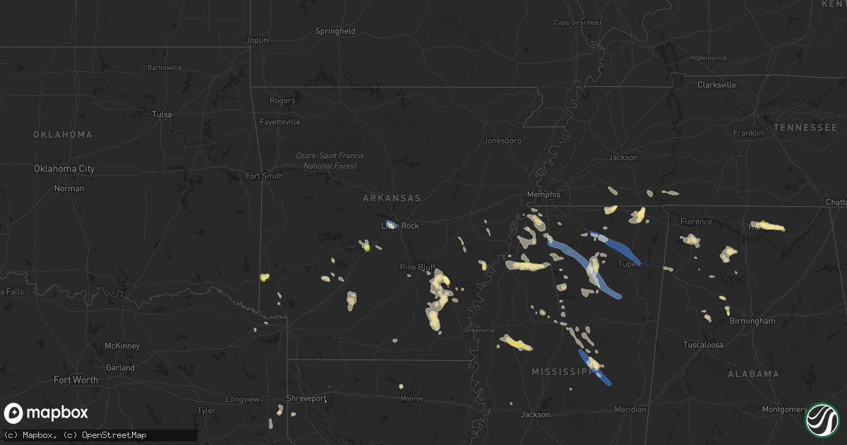
Hail Map in Arkansas on September 6, 2023
Get this storm
September 6 map
$229
one time, instant access
Download today. No call, no setup
Keep the $229
Bought the map and want the full workflow? Apply the entire $229 to a subscription within 7 days. None of it is wasted.
Every map, not just this one
This buys you this map. Subscription and you get every map we run, in the markets you choose from a few cities to whole states to nationwide. Plus real-time alerts the moment a storm fires.
Contact data
Name, contact info, occupancy, even credit band for addresses in the footprint. You go from where it hit to who to call.
Become the source they trust
Unlimited branding weather history reports on demand. You already have the documented answer ready for the property owner, and you are the one who showed up with it.
Property data and RoofTrace estimates
Pull up any address you have got, its value and the exact code rules for that jurisdiction, straight from One Click Code. Then RoofTrace estimates the squares, pitch, and roof value, priced the way you price.
Storm reports in Arkansas
Arkansas
| Date | Description |
|---|---|
| 09/06/20236:40 PM CDT | One pole down in town and transformer fire. Multiple large limbs down across town as well. |
| 09/06/20236:36 PM CDT | Multiple large trees down on ar- highway 35. |
| 09/06/20236:23 PM CDT | Tree down across ar highway 35 near enon baptist church blocking the highway. |
| 09/06/20236:20 PM CDT | A few large trees were uprooted. |
| 09/06/20236:19 PM CDT | Large tree down on highway 278 just east of monticello near the airport. |
| 09/06/20236:18 PM CDT | Monticello airport reported a wind gust of 59 mph. |
| 09/06/20236:17 PM CDT | A few large trees were uprooted. |
| 09/06/20235:23 PM CDT | A power line was reported down across powell street in camden. |
| 09/06/20233:30 PM CDT | A few trees were blown down in this area. |
| 09/06/20233:29 PM CDT | Report from mping: quarter |
| 09/06/20233:27 PM CDT | Received report of quarter-sized hail in dequeen along collin raye dr. |
| 09/06/20233:17 PM CDT | Estimated wind gusts of 60 to 70 mph at the lowes home department store at bowman road. |
| 09/06/20233:14 PM CDT | Numerous trees down at the intersection of rodney parham road and satterfield drive. |
| 09/06/20233:10 PM CDT | Home under construction from damage sustained during the recent march 31st tornado was blown off of its foundation and completely collapsed. |
| 09/06/20233:10 PM CDT | Trees reported blown down. |
| 09/06/20233:09 PM CDT | Large tree down in west little rock at the intersection of springwood drive and birchwood drive. |
| 09/06/20233:07 PM CDT | Multiple power poles were snapped along chenal parkway near the bale chevrolet dealership. |
| 09/06/202312:30 PM CDT | A tree down on the north side of holiday island. |
All States Impacted by Hail Map on September 6, 2023
Cities Impacted by Hail Map on September 6, 2023
- Russellville, OH
- Georgetown, OH
- Dover, KY
- Augusta, KY
- Little Rock, AR
- Malvern, AR
- Gould, AR
- Gillham, AR
- De Queen, AR
- Potts Camp, MS
- Hickory Flat, MS
- Myrtle, MS
- Blue Mountain, MS
- New Albany, MS
- Blue Springs, MS
- Guntown, MS
- Saltillo, MS
- Tupelo, MS
- Mooreville, MS
- Mantachie, MS
- Corinth, MS
- Grady, AR
- Haworth, OK
- Keithville, LA
- Brandywine, WV
- Ashland, MS
- Walnut, MS
- Tiplersville, MS
- Falkner, MS
- Antoine, AR
- Okolona, AR
- Delight, AR
- Broken Bow, OK
- Chidester, AR
- Gurdon, AR
- Morehead, KY
- Hernando, MS
- Hughes, AR
- Benton, AR
- Traskwood, AR
- Pine Bluff, AR
- Elaine, AR
- Mellwood, AR
- Crumrod, AR
- Amity, AR
- Shreveport, LA
- Lockesburg, AR
- Yorktown, AR
- Lena, MS
- Hot Springs National Park, AR
- Lonsdale, AR
- Altheimer, AR
- Downsville, LA
- Cordova, AL
- Quinton, AL
- Ashdown, AR
- Waterford, MS
- Holly Springs, MS
- Lake Cormorant, MS
- Walls, MS
- Jasper, AL
- Watson, AR
- Tillar, AR
- Arkadelphia, AR
- New Boston, TX
- Robinsonville, MS
- Nesbit, MS
- Bolivar, TN
- Saulsbury, TN
- Middleton, TN
- Waskom, TX
- De Berry, TX
- Marshall, TX
- Senatobia, MS
- Como, MS
- Sardis, MS
- Oxford, MS
- Batesville, MS
- University, MS
- Taylor, MS
- Paris, MS
- Banner, MS
- Randolph, MS
- Houlka, MS
- Bruce, MS
- Pontotoc, MS
- Vardaman, MS
- Pittsboro, MS
- Houston, MS
- West Point, MS
- Prairie, MS
- Huntsville, AL
- Brownsboro, AL
- Owens Cross Roads, AL
- Gurley, AL
- Paint Rock, AL
- Trenton, AL
- Ethel, MS
- Kosciusko, MS
- Philadelphia, MS
- Louisville, MS
- McCool, MS
- Carthage, MS
- Union, MS
- Marvell, AR
- Marianna, AR
- Monticello, AR
- Double Springs, AL
- Water Valley, MS
- Addison, AL
- Danville, AL
- Carrollton, MS
- Greenwood, MS
- Moulton, AL
- Coldwater, MS
- Mathias, WV
- Bergton, VA
- Savannah, TN
- Lutts, TN
- Lyon, MS
- Russellville, AL
- Star City, AR
- Marks, MS
- Lambert, MS
- Calhoun City, MS
- Strasburg, VA
- Middletown, VA
- Sledge, MS
- Dundee, MS
- Tuscumbia, AL
- Twilight, WV
- Roe, AR
- Casscoe, AR
- Swanton, OH
- Delta, OH
- Dumas, AR
- Crenshaw, MS
- Sarah, MS
- Tunica, MS
- Logan, AL
- Cullman, AL
- Michie, TN
- Stantonville, TN
- Shiloh, TN
- Coahoma, MS
- Winona, MS
- Clarksdale, MS
- Powellton, WV
- Carthage, TX
- Rienzi, MS
- De Witt, AR
- Crocketts Bluff, AR
- Glen, MS
- Front Royal, VA
- Linden, VA
- Parrish, AL
- Hartselle, AL
- Norwood, LA
- Thaxton, MS
- Ecru, MS
- Strong, AR
- El Dorado, AR
- Hollandale, MS
- Moro, AR
- Tchula, MS
- Belzoni, MS
- Isola, MS
- Big Creek, MS
- Pickens, AR
- Athens, MI
- Quincy, MI
- Tekonsha, MI
- Burlington, MI
- Coldwater, MI
- Union City, MI
- Phil Campbell, AL
- Etta, MS
- Berry, AL
- Coffeeville, MS
- Haleyville, AL
- Courtland, MS
- Pope, MS
- Clyde, TX
- Reeves, LA
- Ragley, LA
- Toms Brook, VA
- Madison, AL
- Hamilton, AL
- Vina, AL
- Doyline, LA
- Hamburg, AR
- Fountain Hill, AR
- Grenada, MS
- Itta Bena, MS
- Inverness, MS
- Minden, LA
- Harvest, AL
- Sand Creek, MI
- Tillatoba, MS
- Scobey, MS
- Northport, AL
- De Kalb, TX
- Simms, TX
- Belva, WV
- Kimberly, WV
- Pocahontas, TN
- Noxapater, MS
- Edwards, MS
- Bolton, MS
- Stewart, MS
- French Camp, MS
- Kilmichael, MS
- Weir, MS
- Eupora, MS
- Duck Hill, MS
- Vaiden, MS
- Adamsville, TN
- McCarley, MS
- Ackerman, MS
- Schlater, MS
- Edon, OH
- Crane Hill, AL


