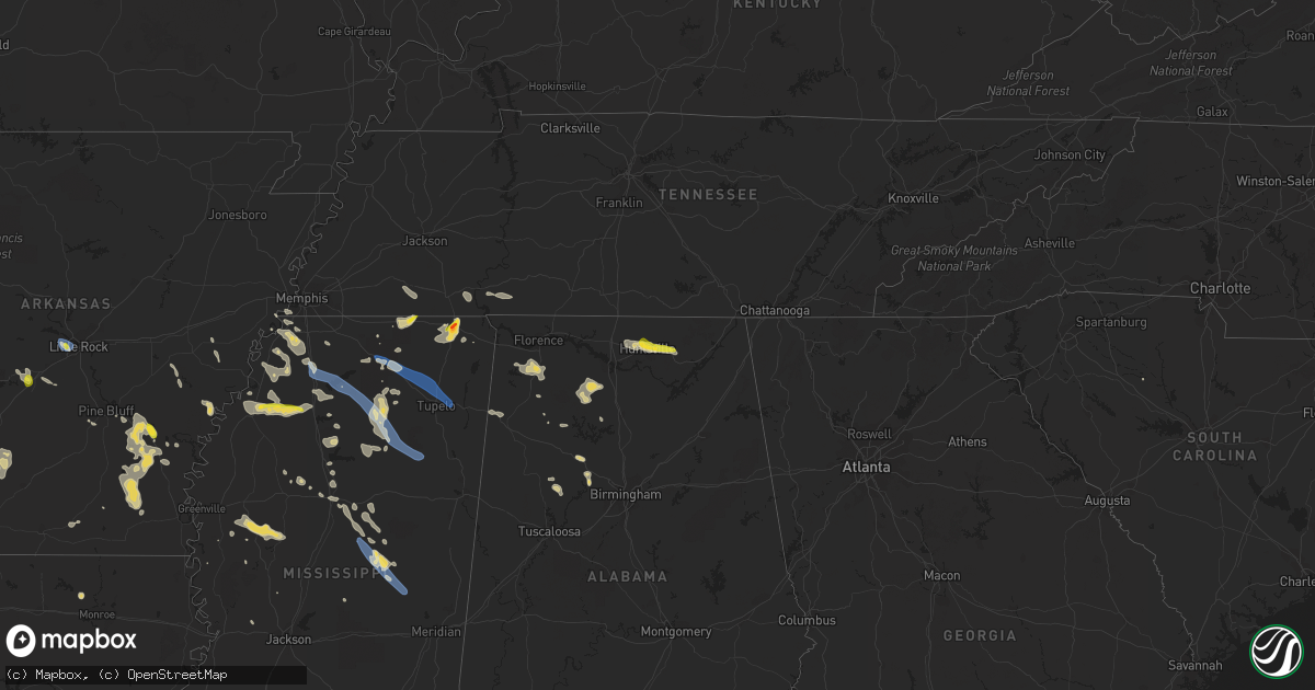
Hail Map on September 6, 2023
Get this storm
September 6 map
$229
one time, instant access
Download today. No call, no setup
Keep the $229
Bought the map and want the full workflow? Apply the entire $229 to a subscription within 7 days. None of it is wasted.
Every map, not just this one
This buys you this map. Subscription and you get every map we run, in the markets you choose from a few cities to whole states to nationwide. Plus real-time alerts the moment a storm fires.
Contact data
Name, contact info, occupancy, even credit band for addresses in the footprint. You go from where it hit to who to call.
Become the source they trust
Unlimited branding weather history reports on demand. You already have the documented answer ready for the property owner, and you are the one who showed up with it.
Property data and RoofTrace estimates
Pull up any address you have got, its value and the exact code rules for that jurisdiction, straight from One Click Code. Then RoofTrace estimates the squares, pitch, and roof value, priced the way you price.
States Impacted by Hail Map on September 6, 2023
Storm reports
Maryland
| Date | Description |
|---|---|
| 09/06/20235:40 PM CDT | Rough run road closed west of the va state line before fort seybert due to downed trees. |
Oklahoma
| Date | Description |
|---|---|
| 09/06/20234:36 PM CDT | Received report of trees downed along 259a in beavers bend state park. |
New York
| Date | Description |
|---|---|
| 09/05/202310:24 PM CDT | Tree down on state rt 3 in ellisburg. |
Pennsylvania
| Date | Description |
|---|---|
| 09/06/20233:10 PM CDT | Tree downed along hershey road from outflow winds ahead of a thunderstorm. |
Arkansas
| Date | Description |
|---|---|
| 09/06/20236:40 PM CDT | One pole down in town and transformer fire. Multiple large limbs down across town as well. |
| 09/06/20236:36 PM CDT | Multiple large trees down on ar- highway 35. |
| 09/06/20236:23 PM CDT | Tree down across ar highway 35 near enon baptist church blocking the highway. |
| 09/06/20236:20 PM CDT | A few large trees were uprooted. |
| 09/06/20236:19 PM CDT | Large tree down on highway 278 just east of monticello near the airport. |
| 09/06/20236:18 PM CDT | Monticello airport reported a wind gust of 59 mph. |
| 09/06/20236:17 PM CDT | A few large trees were uprooted. |
| 09/06/20235:23 PM CDT | A power line was reported down across powell street in camden. |
| 09/06/20233:30 PM CDT | A few trees were blown down in this area. |
| 09/06/20233:29 PM CDT | Report from mping: quarter |
| 09/06/20233:27 PM CDT | Received report of quarter-sized hail in dequeen along collin raye dr. |
| 09/06/20233:17 PM CDT | Estimated wind gusts of 60 to 70 mph at the lowes home department store at bowman road. |
| 09/06/20233:14 PM CDT | Numerous trees down at the intersection of rodney parham road and satterfield drive. |
| 09/06/20233:10 PM CDT | Trees reported blown down. |
| 09/06/20233:10 PM CDT | Home under construction from damage sustained during the recent march 31st tornado was blown off of its foundation and completely collapsed. |
| 09/06/20233:09 PM CDT | Large tree down in west little rock at the intersection of springwood drive and birchwood drive. |
| 09/06/20233:07 PM CDT | Multiple power poles were snapped along chenal parkway near the bale chevrolet dealership. |
| 09/06/202312:30 PM CDT | A tree down on the north side of holiday island. |
Virginia
| Date | Description |
|---|---|
| 09/06/20236:20 PM CDT | A tree was down in the bryce area. |
| 09/06/20235:33 PM CDT | Corrected location. Hall springs road closed in multiple locations due to trees down. |
| 09/06/20235:33 PM CDT | Hall springs road closed in multiple locations due to trees down. |
| 09/05/20237:42 PM CDT | A gazebo was blown over shattering a window at the signal knob recreation center. |
| 09/05/20237:36 PM CDT | Trees down on the north side of strasburg per 911 center. |
| 09/05/20237:32 PM CDT | Powerlines were down along horseshoe lane. |
Alabama
| Date | Description |
|---|---|
| 09/06/20233:35 PM CDT | Numerous trees down with powerlines and power poles down in jasper. Time estimated by radar. |
| 09/05/20238:43 PM CDT | A local report indicates 1.00 inch wind near 4 NE Huntsville |
| 09/05/20238:40 PM CDT | A local report indicates 1.00 inch wind near 5 N Huntsville |
| 09/05/20238:27 PM CDT | Roof damage to a house on hwy 36 and county road 30. |
| 09/05/20238:27 PM CDT | Roof |
Mississippi
| Date | Description |
|---|---|
| 09/06/20236:59 PM CDT | Trees down on several roads in and around the city of oxford. |
| 09/06/20236:57 PM CDT | Trees down on county road 105. |
| 09/06/20236:20 PM CDT | Numerous trees down in the neighborhood adjacent to the back acres country club near i-55 and highway 740. |
| 09/06/20236:10 PM CDT | Quarter size fell for approximately 5 minutes in the city of marks. |
| 09/06/20235:56 PM CDT | Trees and power lines down on yellow dog road and briarwood. |
| 09/06/20235:55 PM CDT | Multiple trees down on highway 9 south in pontotoc. |
| 09/06/20235:27 PM CDT | Trees down on county road 216. Time is radar estimated. |
| 09/06/20235:25 PM CDT | Quarter-sized hail observed in downtown corinth. |
| 09/06/20235:25 PM CDT | Photo of hail up to the size of a golf ball in corinth. |
| 09/06/20235:10 PM CDT | Trees down on road 1124 in the mooreville area. |
| 09/06/20235:00 PM CDT | Trees down on county road 831 east of old saltillo road. |
| 09/06/20234:50 PM CDT | Trees down in the 200 block of birmingham ridge road in the blair community. |
| 09/06/20234:45 PM CDT | Photo of half-dollar sized hail in the three forks area. |
| 09/06/20234:32 PM CDT | Trees where down and shingles where blown off a roof in north haven community. Time is radar estimated. |
| 09/06/20234:30 PM CDT | Large tree down at residence along highway 30 east near keownville. |
| 09/06/20234:25 PM CDT | Significant roof damage to a large metal building structure. |
| 09/06/20234:05 PM CDT | Several large trees uprooted along old highway 78 and a metal roof was peeled off a building. |
| 09/06/20233:58 PM CDT | Numerous trees down and damage to the sports complex. |
| 09/05/202310:51 PM CDT | Knjw had a 53kt gust. |
| 09/05/202310:30 PM CDT | Measured at the eoc. |
| 09/05/202310:27 PM CDT | Tree down along road 602. |
| 09/05/202310:27 PM CDT | Tree do |
| 09/05/202310:07 PM CDT | Trees down along williamsville rd. |
| 09/05/202310:02 PM CDT | Trees down along hwy 14 near road 5001. |
| 09/05/20239:47 PM CDT | Scattered trees down hwy 12 and road 3122. |
| 09/05/20239:36 PM CDT | Scattered trees down s of ethel... A few down across road 5053. |
| 09/05/20239:35 PM CDT | Multiple trees down in and around poplar creek and in the s part of the county. Several across roads. |
| 09/05/20239:35 PM CDT | Multiple trees down in and around poplar creek and in the s part of the county. |
| 09/05/20239:28 PM CDT | Several trees and lines down outside of and in town. |
| 09/05/20239:07 PM CDT | A few trees and power lines down. |
| 09/05/20239:00 PM CDT | A few trees down along pleasant grove rd. |
| 09/05/20238:42 PM CDT | A few trees down and large limbs... Power was also out for a short period of time. |
| 09/05/20238:27 PM CDT | A couple trees down near hwy 7 and 133. |
| 09/05/20238:27 PM CDT | Large tree took down a large span of power line. |
| 09/05/20238:27 PM CDT | Corrects time of report from 1 s tchula. Reports and photos show a mobile home with major roof damage on sycamore street in the tchula area. |
| 09/05/20238:15 PM CDT | Corrects previous tstm wnd dmg report from 1 s tchula. Reports and photos show a mobile home with major roof damage on sycamore street in the tchula area. |
| 09/05/20237:56 PM CDT | Large tree down in thorn... Ms. Time is radar estimated. |
| 09/05/20237:25 PM CDT | Large tree across highway 9n on the calhoun-pontotoc county line. |
| 09/05/20237:15 PM CDT | Tree down on hwy 334 near springville. Time is radar estimated. (m |
| 09/05/20237:15 PM CDT | Tree down on hwy 334 near springville. Time is radar estimated. |
| 09/05/20237:15 PM CDT | Reports and photos show a mobile home with major roof damage on sycamore street in the tchula area. |
| 09/05/20237:13 PM CDT | A few trees down on highway 331 near tula. Time is radar estimated. |
| 09/05/20237:00 PM CDT | Trees down on highway 7 south of the city of oxford. |
Michigan
| Date | Description |
|---|---|
| 09/05/20237:06 PM CDT | Dispatch reports a tree and wires down on n quick st |
West Virginia
| Date | Description |
|---|---|
| 09/06/20236:01 PM CDT | Two trees were down along wv 259 near sawmill lane. |
| 09/06/20235:40 PM CDT | Corrected location. Rough run road closed west of the va state line before fort seybert due to downed trees. |
| 09/05/20239:15 PM CDT | Tree down at deep water mountain. |
| 09/05/20239:14 PM CDT | Tree down on power lines. |
Cities Impacted by Hail Map on September 6, 2023
- Russellville, OH
- Georgetown, OH
- Dover, KY
- Augusta, KY
- Little Rock, AR
- Malvern, AR
- Gould, AR
- Gillham, AR
- De Queen, AR
- Potts Camp, MS
- Hickory Flat, MS
- Myrtle, MS
- Blue Mountain, MS
- New Albany, MS
- Blue Springs, MS
- Guntown, MS
- Saltillo, MS
- Tupelo, MS
- Mooreville, MS
- Mantachie, MS
- Corinth, MS
- Grady, AR
- Haworth, OK
- Keithville, LA
- Brandywine, WV
- Ashland, MS
- Walnut, MS
- Tiplersville, MS
- Falkner, MS
- Antoine, AR
- Okolona, AR
- Delight, AR
- Broken Bow, OK
- Chidester, AR
- Gurdon, AR
- Morehead, KY
- Hernando, MS
- Hughes, AR
- Benton, AR
- Traskwood, AR
- Pine Bluff, AR
- Elaine, AR
- Mellwood, AR
- Crumrod, AR
- Amity, AR
- Shreveport, LA
- Lockesburg, AR
- Yorktown, AR
- Lena, MS
- Hot Springs National Park, AR
- Lonsdale, AR
- Altheimer, AR
- Downsville, LA
- Cordova, AL
- Quinton, AL
- Ashdown, AR
- Waterford, MS
- Holly Springs, MS
- Lake Cormorant, MS
- Walls, MS
- Jasper, AL
- Watson, AR
- Tillar, AR
- Arkadelphia, AR
- New Boston, TX
- Robinsonville, MS
- Nesbit, MS
- Bolivar, TN
- Saulsbury, TN
- Middleton, TN
- Waskom, TX
- De Berry, TX
- Marshall, TX
- Senatobia, MS
- Como, MS
- Sardis, MS
- Oxford, MS
- Batesville, MS
- University, MS
- Taylor, MS
- Paris, MS
- Banner, MS
- Randolph, MS
- Houlka, MS
- Bruce, MS
- Pontotoc, MS
- Vardaman, MS
- Pittsboro, MS
- Houston, MS
- West Point, MS
- Prairie, MS
- Huntsville, AL
- Brownsboro, AL
- Owens Cross Roads, AL
- Gurley, AL
- Paint Rock, AL
- Trenton, AL
- Ethel, MS
- Kosciusko, MS
- Philadelphia, MS
- Louisville, MS
- McCool, MS
- Carthage, MS
- Union, MS
- Marvell, AR
- Marianna, AR
- Monticello, AR
- Double Springs, AL
- Water Valley, MS
- Addison, AL
- Danville, AL
- Carrollton, MS
- Greenwood, MS
- Moulton, AL
- Coldwater, MS
- Mathias, WV
- Bergton, VA
- Savannah, TN
- Lutts, TN
- Lyon, MS
- Russellville, AL
- Star City, AR
- Marks, MS
- Lambert, MS
- Calhoun City, MS
- Strasburg, VA
- Middletown, VA
- Sledge, MS
- Dundee, MS
- Tuscumbia, AL
- Twilight, WV
- Roe, AR
- Casscoe, AR
- Swanton, OH
- Delta, OH
- Dumas, AR
- Crenshaw, MS
- Sarah, MS
- Tunica, MS
- Logan, AL
- Cullman, AL
- Michie, TN
- Stantonville, TN
- Shiloh, TN
- Coahoma, MS
- Winona, MS
- Clarksdale, MS
- Powellton, WV
- Carthage, TX
- Rienzi, MS
- De Witt, AR
- Crocketts Bluff, AR
- Glen, MS
- Front Royal, VA
- Linden, VA
- Parrish, AL
- Hartselle, AL
- Norwood, LA
- Thaxton, MS
- Ecru, MS
- Strong, AR
- El Dorado, AR
- Hollandale, MS
- Moro, AR
- Tchula, MS
- Belzoni, MS
- Isola, MS
- Big Creek, MS
- Pickens, AR
- Athens, MI
- Quincy, MI
- Tekonsha, MI
- Burlington, MI
- Coldwater, MI
- Union City, MI
- Phil Campbell, AL
- Etta, MS
- Berry, AL
- Coffeeville, MS
- Haleyville, AL
- Courtland, MS
- Pope, MS
- Clyde, TX
- Reeves, LA
- Ragley, LA
- Toms Brook, VA
- Madison, AL
- Hamilton, AL
- Vina, AL
- Doyline, LA
- Hamburg, AR
- Fountain Hill, AR
- Grenada, MS
- Itta Bena, MS
- Inverness, MS
- Minden, LA
- Harvest, AL
- Sand Creek, MI
- Tillatoba, MS
- Scobey, MS
- Northport, AL
- De Kalb, TX
- Simms, TX
- Belva, WV
- Kimberly, WV
- Pocahontas, TN
- Noxapater, MS
- Edwards, MS
- Bolton, MS
- Stewart, MS
- French Camp, MS
- Kilmichael, MS
- Weir, MS
- Eupora, MS
- Duck Hill, MS
- Vaiden, MS
- Adamsville, TN
- McCarley, MS
- Ackerman, MS
- Schlater, MS
- Edon, OH
- Crane Hill, AL