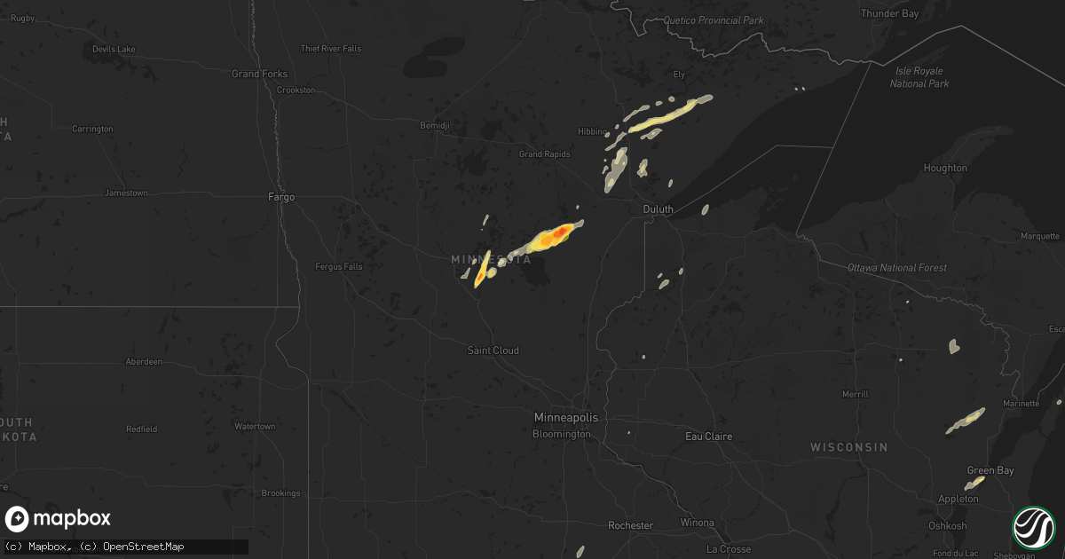
Hail Map in Minnesota on September 5, 2023
Get this storm
September 5 map
$229
one time, instant access
Download today. No call, no setup
Keep the $229
Bought the map and want the full workflow? Apply the entire $229 to a subscription within 7 days. None of it is wasted.
Every map, not just this one
This buys you this map. Subscription and you get every map we run, in the markets you choose from a few cities to whole states to nationwide. Plus real-time alerts the moment a storm fires.
Contact data
Name, contact info, occupancy, even credit band for addresses in the footprint. You go from where it hit to who to call.
Become the source they trust
Unlimited branding weather history reports on demand. You already have the documented answer ready for the property owner, and you are the one who showed up with it.
Property data and RoofTrace estimates
Pull up any address you have got, its value and the exact code rules for that jurisdiction, straight from One Click Code. Then RoofTrace estimates the squares, pitch, and roof value, priced the way you price.
Storm reports in Minnesota
Minnesota
| Date | Description |
|---|---|
| 09/05/20236:35 PM CDT | Multiple large trees down and power out. Time estimated from radar. |
| 09/05/20236:26 PM CDT | A local report indicates 2.75 inch wind near 3 SSE Mcgregor |
| 09/05/20236:22 PM CDT | Report via social media with photo. Observer states they had hail of all sizes up to golf ball and egg size shown in photo. |
| 09/05/20236:05 PM CDT | Photo sent in via social media of egg sized hail measured next to a golf ball. |
| 09/05/20236:02 PM CDT | A local report indicates 1.50 inch wind near 5 NE Glen |
| 09/05/20235:43 PM CDT | Several trees snapped off. Report and photos via social media. Time estimated off radar. |
| 09/05/20234:38 PM CDT | Numerous trees were reported down on boga lake in the bwca. Time estimated from radar. |
| 09/05/20234:25 PM CDT | A local report indicates 1.25 inch wind near 1 W Barrows |
| 09/05/20234:17 PM CDT | Storm blew the top of a white pine off. Time estimated off radar. |
| 09/05/20234:11 PM CDT | Photo was received showing hail with a quarter with the hail being about twice as large as the quarter in diameter. |
| 09/05/20233:50 PM CDT | A local report indicates 1.00 inch wind near Hoyt Lakes |
| 09/05/20233:40 PM CDT | Photos were received showing large tree limbs down in hoyt lakes. One limb looked to be at least 2 feet in diameter. |
| 09/05/20233:30 PM CDT | Report via social media with photos. Several small to medium sized trees down and reported power lines down as well. Time estimated from report and radar. |
| 09/05/20233:30 PM CDT | Numerous trees uprooted or snapped off along bass lake rd. Time estimated off radar. |
| 09/05/20233:20 PM CDT | Strong winds with storms knocked several trees down along vermilion trail. |
| 09/05/20232:56 PM CDT | Numerous trees were down onto power lines just off county road 7 near old mesaba and ramshaw roads and the railroad tracks. Tree limbs ranged in diameter from 4 to 12 i |
All States Impacted by Hail Map on September 5, 2023
Cities Impacted by Hail Map on September 5, 2023
- Isabella, MN
- Brainerd, MN
- Fort Ripley, MN
- Baxter, MN
- Gilbert, MN
- Aurora, MN
- Hoyt Lakes, MN
- Babbitt, MN
- Memphis, TN
- Germantown, TN
- Cotton, MN
- Dawson Springs, KY
- Kevil, KY
- Floodwood, MN
- Middleton, TN
- Fulton, KY
- Luther, OK
- Trenton, TN
- Nunnelly, TN
- Centerville, TN
- Pine River, MN
- Pequot Lakes, MN
- Bowling Green, KY
- Pillager, MN
- Wellston, OK
- Crofton, KY
- Woodlawn, TN
- Clarksville, TN
- Iron, MN
- Mountain Iron, MN
- Mayfield, KY
- Duluth, MN
- Canyon, MN
- Cunningham, KY
- Bardwell, KY
- Melber, KY
- Fancy Farm, KY
- Only, TN
- Farmington, KY
- Sedalia, KY
- Jones, OK
- Choctaw, OK
- Harrah, OK
- Makinen, MN
- Dukedom, TN
- Centreville, MS
- Eveleth, MN
- Brimson, MN
- Benton, KY
- Hardin, KY
- Water Valley, MS
- Meadowlands, MN
- Paducah, KY
- West Paducah, KY
- Forbes, MN
- Hibbing, MN
- Embarrass, MN
- Castalian Springs, TN
- Hartsville, TN
- Alamo, TN
- Friendship, TN
- Cushing, MN
- Virginia, MN
- Princeton, KY
- Alborn, MN
- Barlow, KY
- Wickliffe, KY
- Chandler, OK
- Aitkin, MN
- Mcgregor, MN
- Tamarack, MN
- Pleasant Hill, MO
- Kingsville, MO
- Holden, MO
- Garden City, MO
- Creighton, MO
- Blairstown, MO
- Urich, MO
- Centerview, MO
- Drumright, OK
- Mannford, OK
- Sand Springs, OK
- Hopkinsville, KY
- Aldrich, MO
- Butler, MO
- Talala, OK
- Ramona, OK
- Nowata, OK
- Grand Marais, MN
- San Angelo, TX
- Cole Camp, MO
- Hayward, MN
- Electra, TX
- Cushing, OK
- Depew, OK
- Stroud, OK
- Blooming Prairie, MN
- Hollandale, MN
- Austin, MN
- Mcloud, OK
- Newalla, OK
- Shawnee, OK
- Tecumseh, OK
- Anadarko, OK
- Fort Cobb, OK
- Rockville, MO
- Rich Hill, MO
- Windsor, MO
- Knob Noster, MO
- Warrensburg, MO
- Wildersville, TN
- Huron, TN
- Lexington, TN
- Cedar Grove, TN
- Kettle River, MN
- River Falls, WI
- Girard, KS
- Farlington, KS
- Walnut, KS
- Oswego, KS
- Geronimo, OK
- Pittsburg, KS
- Robert Lee, TX
- Mertzon, TX
- Norman, OK
- Green Ridge, MO
- Sedalia, MO
- Bolivar, MO
- Carthage, MO
- Alba, MO
- Jasper, MO
- Oronogo, MO
- Webb City, MO
- Delaware, OK
- Harrisonville, MO
- Big Cabin, OK
- Chelsea, OK
- McCune, KS
- Parsons, KS
- Parma, MI
- Jackson, MI
- Archie, MO
- Gordon, WI
- Le Roy, MN
- Taopi, MN
- Adams, MN
- Saint Ansgar, IA
- Osage, IA
- Stacyville, IA
- McIntire, IA
- Jackson, LA
- Saint Francisville, LA
- Elgin, OK
- Lawton, OK
- Vinita, OK
- Clinton, MO
- Montrose, MO
- Eola, TX
- Miles, TX
- Chilhowee, MO
- Arlington, TN
- Golden City, MO
- Reeds, MO
- Ionia, MO
- Fletcher, OK
- Saint Paul, KS
- Slater, MO
- Gilliam, MO
- Apache, OK
- Collinsville, OK
- Olive Branch, MS
- Noble, OK
- Purcell, OK
- Lexington, OK
- Diamond, MO
- Altamont, KS
- Albert Lea, MN
- Wright, MN
- Deerwood, MN
- Odessa, MO
- Westbrook, TX
- Iowa Park, TX
- Adair, OK
- Warsaw, MO
- Deepwater, MO
- Hepler, KS
- Frontenac, KS
- Franklin, KS
- Arma, KS
- Indiahoma, OK
- Bartlesville, OK
- Tulsa, OK
- Mora, MO
- Lincoln, MO
- Galesburg, KS
- Coldwater, MS
- Hernando, MS
- Lone Jack, MO
- Peculiar, MO
- Tunica, MS
- Half Way, MO
- Oklahoma City, OK
- Joplin, MO
- Meeker, OK
- Appleton City, MO
- Bates City, MO
- Danbury, WI
- Pierce City, MO
- Granby, MO
- Crowell, TX
- Bristow, OK
- Port Wing, WI
- Lenapah, OK
- Claremore, OK
- Skiatook, OK
- Oologah, OK
- Vera, OK
- Coffeyville, KS
- Mound Valley, KS
- Liberty, KS
- Weaubleau, MO
- Loraine, TX
- Colorado City, TX
- Calhoun, MO
- Garden City, TX
- Big Lake, TX
- Little Falls, MN
- Tuttle, OK
- Dunkerton, IA
- Waterloo, IA
- Bryson, TX
- Jacksboro, TX
- Fairbank, IA
- Hartshorn, MO
- Buffalo, MO
- Wall, TX
- Vancourt, TX
- Windthorst, TX
- Smithton, MO
- Lebanon, MO
- Black, MO
- Manchester, IA
- Minong, WI
- Winters, TX
- Worthington, IA
- Hopkinton, IA
- Dyersville, IA
- Epworth, IA
- Delhi, IA
- Farley, IA
- Earlville, IA
- Potosi, MO
- Steelville, MO
- Davisville, MO
- Independence, IA
- Galena, MO
- Shell Knob, MO
- Bourbon, MO
- Leasburg, MO
- Salina, OK
- Eucha, OK
- Seymour, TX
- Dubuque, IA
- Henrietta, TX
- Jesup, IA
- La Porte City, IA
- Salem, MO
- Spencer, OK
- Republic, MO
- Viburnum, MO
- Cherryville, MO
- Valley Springs, AR
- Harrisburg, MO
- Springfield, MO
- Brookline, MO
- Rowley, IA
- Walker, IA
- Aurora, IA
- Masonville, IA
- Ryan, IA
- Coggon, IA
- Winthrop, IA
- Quasqueton, IA
- Lesterville, MO
- Middle Brook, MO
- Belleview, MO
- Ironton, MO
- Luck, WI
- Comstock, WI
- Balsam Lake, WI
- Bunker, MO
- Loving, TX
- Spavinaw, OK
- Polk, MO
- Pittsburg, MO
- Hermitage, MO
- Flemington, MO
- Stover, MO
- Versailles, MO
- Reeds Spring, MO
- Huntsville, AR
- Vanzant, MO
- Willow Springs, MO
- Cabool, MO
- Rueter, MO
- Protem, MO
- Hindsville, AR
- Wheatland, MO
- Tuscola, TX
- Senatobia, MS
- Seligman, MO
- Garfield, AR
- Linn Creek, MO
- Camdenton, MO
- Columbia, MO
- Sturgeon, MO
- Hallsville, MO
- Oldfield, MO
- Comanche, OK
- Yuma, TN
- Everton, AR
- Yellville, AR
- Harrison, AR
- Cassville, MO
- Elkader, IA
- Strawberry Point, IA
- Sarcoxie, MO
- La Russell, MO
- Miller, MO
- Lockwood, MO
- Avilla, MO
- Springdale, AR
- Plato, MO
- Roby, MO
- Huggins, MO
- Goodfellow Afb, TX
- Pineville, MO
- Boss, MO
- Tremont, IL
- Wentworth, MO
- Mount Vernon, MO
- Dundee, IA
- Merkel, TX
- Tye, TX
- Rogers, AR
- Eureka Springs, AR
- Marionville, MO
- Stark City, MO
- Neosho, MO
- Lowell, AR
- Fayetteville, AR
- Ovalo, TX
- Morton, IL
- Waurika, OK
- Purcell, MO
- Sunrise Beach, MO
- Compton, AR
- Stotts City, MO
- Jay, OK
- De Pere, WI
- Newark, IL
- Atwood, IL
- Appleton, WI
- Gillett, WI
- Shawano, WI
- Farmer City, IL
- Dewitt, IL
- Earlville, IL
- Ottawa, IL
- Seneca, IL
- Morris, IL
- Marseilles, IL
- Sheridan, IL
- Champaign, IL
- Elcho, WI
- Golden, MO
- Tolono, IL
- Sadorus, IL
- East Dubuque, IL
- Hazel Green, WI
- Saint Joe, AR
- Ludlow, IL
- Peru, IL
- Utica, IL
- La Salle, IL
- Bourbonnais, IL
- Clinton, IL
- Warrensburg, IL
- Chestnut, IL
- Maroa, IL
- Beason, IL
- Lincoln, IL
- Kenney, IL
- Minier, IL
- Hopedale, IL
- Mackinaw, IL
- Eagle Rock, MO
- Downs, IL
- Le Roy, IL
- Wapella, IL
- Heyworth, IL
- Streator, IL
- Camargo, IL
- Villa Grove, IL
- Tuscola, IL
- Summersville, MO
- Kankakee, IL
- Calico Rock, AR
- Delavan, IL
- Elkhart, IL
- Mount Pulaski, IL
- Durango, IA
- Peosta, IA
- Holy Cross, IA
- Green Forest, AR
- Berryville, AR
- Potomac, IL
- Armstrong, IL
- Cisco, IL
- Monticello, IL
- De Land, IL
- Omaha, AR
- Urbana, IL
- Goodman, WI
- Laona, WI
- Armstrong Creek, WI
- Bloomington, IL
- Newman, IL
- Mendota, IL
- Thomasboro, IL
- Rantoul, IL
- Ellsworth, IL
- Alpena, AR
- Mokena, IL
- New Lenox, IL
- Lockport, IL
- Homer Glen, IL
- Eagle River, WI
- Phelps, WI
- Saunemin, IL
- Pontiac, IL
- San Jose, IL
- Momence, IL
- Saint Anne, IL
- Herscher, IL
- Aroma Park, IL
- Bradley, IL
- Chebanse, IL
- Dalzell, IL
- Spring Valley, IL
- El Paso, IL
- Blue Eye, MO
- Hollister, MO
- Branson, MO
- Henderson, TN
- Grant Park, IL
- Chenoa, IL
- Pekin, IL
- Secor, IL
- Baileys Harbor, WI
- Fish Creek, WI
- Smithboro, IL
- Western Grove, AR
- Flippin, AR
- Ivesdale, IL
- White Heath, IL
- New Vienna, IA
- Gifford, IL
- Argenta, IL
- Weldon, IL
- Dewey, IL
- Seymour, IL
- Philo, IL
- Rankin, IL
- Penfield, IL
- Arthur, IL
- Hume, IL
- Mahomet, IL
- Longview, IL
- Pesotum, IL
- Murdock, IL
- Murray, KY
- Kaukauna, WI
- Lena, WI
- Coleman, WI
- Oconto Falls, WI
- Suring, WI
- Hornsby, TN
- Sister Bay, WI


