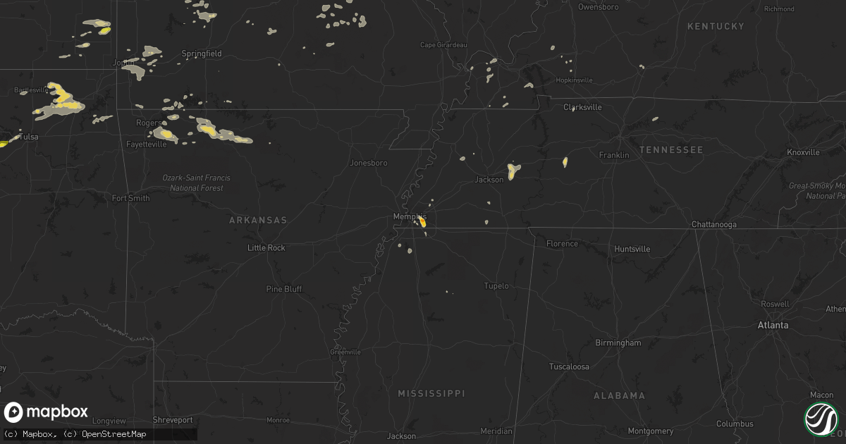
Hail Map on September 5, 2023
Get this storm
September 5 map
$229
one time, instant access
Download today. No call, no setup
Keep the $229
Bought the map and want the full workflow? Apply the entire $229 to a subscription within 7 days. None of it is wasted.
Every map, not just this one
This buys you this map. Subscription and you get every map we run, in the markets you choose from a few cities to whole states to nationwide. Plus real-time alerts the moment a storm fires.
Contact data
Name, contact info, occupancy, even credit band for addresses in the footprint. You go from where it hit to who to call.
Become the source they trust
Unlimited branding weather history reports on demand. You already have the documented answer ready for the property owner, and you are the one who showed up with it.
Property data and RoofTrace estimates
Pull up any address you have got, its value and the exact code rules for that jurisdiction, straight from One Click Code. Then RoofTrace estimates the squares, pitch, and roof value, priced the way you price.
States Impacted by Hail Map on September 5, 2023
Storm reports
Illinois
| Date | Description |
|---|---|
| 09/05/20235:58 AM CDT | A local report indicates 60 MPH wind near 2 NE Orland Hills |
| 09/05/20234:28 AM CDT | Repo |
| 09/05/20234:28 AM CDT | Report relayed via social media of small to medium size branches downed in naperville. Time estimated by radar. |
| 09/05/20234:26 AM CDT | Photo shared on social media showing a snapped tree near edward hospital in naperville. Other tree damage also observed in the area. Time estimated from radar. |
Arkansas
| Date | Description |
|---|---|
| 09/05/202312:43 AM CDT | Several trees and power lines down. |
| 09/04/202311:53 PM CDT | Trees down and damage to a gazebo. |
| 09/04/202311:51 PM CDT | A local report indicates 59 MPH wind near 2 SW Bentonville |
Kansas
| Date | Description |
|---|---|
| 09/04/20237:13 PM CDT | Social media picture of hail in girard. |
Texas
| Date | Description |
|---|---|
| 09/05/20236:24 PM CDT | Mesonet station ur164 westbrook |
| 09/04/20239:55 PM CDT | West texas mesonet site 2 e wall measured a 58 mph wind gust. |
| 09/04/20239:45 PM CDT | Small tree limbs down... Winds estimated over 60 mph. |
| 09/04/20239:10 PM CDT | Damage occurred to multiple buildings at taylor electric coop facility. Roofing peeled back... Garage doors bent and imploded... And power poles knocked down. |
| 09/04/20237:28 PM CDT | Downburst caused damage to power lines... Fences... And several buildings including one home. Time estimated by radar. |
Oklahoma
| Date | Description |
|---|---|
| 09/05/20236:57 PM CDT | Delayed report. Large tree blown down... Blocking a portion of the pottawatomie and wilshire road intersection. Radar estimated time. |
| 09/05/20236:55 PM CDT | Delayed report. Four power poles snapped at the base. Radar estimated time. |
| 09/05/20236:55 PM CDT | *** 1 inj *** travel trailer blown over... Landing on a mobile home. Time estimated via radar. |
| 09/05/20236:50 PM CDT | Power pole snapped... Leaning on a building. Time estimated via radar. |
| 09/05/20236:45 PM CDT | Power line down. Time estimated via radar. |
| 09/05/20236:25 PM CDT | Several power poles blown down. Time estimated via radar. |
| 09/05/20236:20 PM CDT | Delayed report. Damage to a metal shed and fence. Radar estimated time. |
| 09/05/20236:10 PM CDT | Delayed report. Damage to the roof and exterior wall of a residence. Radar estimated time. |
| 09/05/20235:45 PM CDT | Delayed report. The back porch of a residence was lofted... Landing on a portion of the roof. Radar estimated time. |
| 09/05/20235:45 PM CDT | Large tree split in half and power pole damage. Time estimated via radar. |
| 09/05/20235:45 PM CDT | Powerlines reported down throughout the city of wellston. Time estimated via radar. |
| 09/04/202310:55 PM CDT | A local report indicates 60 MPH wind near 2 ENE Grove |
| 09/04/20239:53 PM CDT | Siding removed from barn with debris strewn across property. Time estimated by radar. |
| 09/04/20239:50 PM CDT | Trees down near harrah rd and e tecumseh rd. Radar estimated time. |
| 09/04/20239:40 PM CDT | Several trees damaged near indian point rd. |
| 09/04/20239:35 PM CDT | Large tree limbs blown down. Radar estimated time. |
| 09/04/20239:27 PM CDT | Dock and boat damage at the grand lake sailing club |
| 09/04/20239:15 PM CDT | Extensive damage to storage building. Boat dock also damaged. |
| 09/04/20238:40 PM CDT | Delayed report. Roof removed from a mobile home. Radar estimated time. |
| 09/04/20238:08 PM CDT | A local report indicates 60 MPH wind near Tecumseh |
| 09/04/20238:05 PM CDT | Public reported very strong winds which resulted in tree damage. |
| 09/04/20238:00 PM CDT | Delayed report. Three boathouses damaged on lake ellsworth. Radar estimated time. |
| 09/04/20237:54 PM CDT | A local report indicates 1.00 inch wind near 5 ENE Lake Lawtonka |
| 09/04/20237:30 PM CDT | Picture showing a portion of a roof removed from a mobile home. |
| 09/04/20237:20 PM CDT | Delayed report. Powerlines down near the intersection of highway 177 and e 1070 road. Radar estimated time. |
| 09/04/20237:14 PM CDT | Report from mping: quarter |
| 09/04/20237:12 PM CDT | A local report indicates 1.25 inch wind near 5 S Mannford |
| 09/04/20237:00 PM CDT | Small tree limbs also reported down. |
Missouri
| Date | Description |
|---|---|
| 09/05/20236:45 PM CDT | Report from mping: quarter |
| 09/05/20236:35 PM CDT | A local report indicates 1.50 inch wind near Kingsville |
| 09/05/20236:33 PM CDT | A local report indicates 1.00 inch wind near Kingsville |
| 09/05/20236:20 PM CDT | A local report indicates 1.50 inch wind near 5 SE Lake Lafayette |
| 09/05/202312:05 AM CDT | Large limb downed on a home in ava. |
| 09/04/202310:54 PM CDT | Delayed report. Tree branches around 6 inches snapped... And power out through washburn and seligman. |
| 09/04/20239:37 PM CDT | Delayed report 2 miles s of sarcoxie on racoon rd 4 inch limbs approximately 8 inches long down. |
| 09/04/20239:22 PM CDT | Reports of trees downed in eldon and tuscumbia. |
| 09/04/20239:07 PM CDT | Reported damage to a metal building. |
| 09/04/20238:50 PM CDT | A tree was reported downed at highway 52 and highway 135. Another tree was downed in versailles and the ivy bend area in morgan co. |
| 09/04/20237:58 PM CDT | A local report indicates 1.00 inch wind near Montrose |
| 09/04/20237:51 PM CDT | A local report indicates 1.00 inch wind near 1 E Windsor |
| 09/04/20237:25 PM CDT | Home weather station just east of whiteman afb. |
Kentucky
| Date | Description |
|---|---|
| 09/05/20236:24 PM CDT | Corrects previous tstm wnd dmg report from 4 ssw hopkinsville. Mostly tree damage reported near gary lane and hillwood circle. Possible tornado. |
| 09/05/20236:24 PM CDT | Extensive damage reported near gary lane and hillwood circle. Possible tornado. |
| 09/05/20234:09 PM CDT | Late report. A large oak tree was uprooted and another large tree was snapped at its base. Several other large limbs down. Damage occurred at 1230 gholson rd. |
Tennessee
| Date | Description |
|---|---|
| 09/05/20236:06 PM CDT | Trees down at intersection of battleground dr. And wildersville road just south of i-40. Time is radar estimated. |
| 09/05/20235:15 PM CDT | Caller reported large hail up to ping-pong size lasting approximately 5 minutes resulting in small dents on their car. |
Wisconsin
| Date | Description |
|---|---|
| 09/05/20236:10 PM CDT | Corrects previous non-tstm wnd gst report from 13 ne sand bay. Mesonet station disw3 devils island. Marine thunderstorm wind gust from peak gust measurement. |
| 09/05/20236:03 AM CDT | A local report indicates 1.00 inch wind near 3 SW De Pere |
Minnesota
| Date | Description |
|---|---|
| 09/05/20236:35 PM CDT | Multiple large trees down and power out. Time estimated from radar. |
| 09/05/20236:26 PM CDT | A local report indicates 2.75 inch wind near 3 SSE Mcgregor |
| 09/05/20236:22 PM CDT | Report via social media with photo. Observer states they had hail of all sizes up to golf ball and egg size shown in photo. |
| 09/05/20236:05 PM CDT | Photo sent in via social media of egg sized hail measured next to a golf ball. |
| 09/05/20236:02 PM CDT | A local report indicates 1.50 inch wind near 5 NE Glen |
| 09/05/20235:43 PM CDT | Several trees snapped off. Report and photos via social media. Time estimated off radar. |
| 09/05/20234:38 PM CDT | Numerous trees were reported down on boga lake in the bwca. Time estimated from radar. |
| 09/05/20234:25 PM CDT | A local report indicates 1.25 inch wind near 1 W Barrows |
| 09/05/20234:17 PM CDT | Storm blew the top of a white pine off. Time estimated off radar. |
| 09/05/20234:11 PM CDT | Photo was received showing hail with a quarter with the hail being about twice as large as the quarter in diameter. |
| 09/05/20233:50 PM CDT | A local report indicates 1.00 inch wind near Hoyt Lakes |
| 09/05/20233:40 PM CDT | Photos were received showing large tree limbs down in hoyt lakes. One limb looked to be at least 2 feet in diameter. |
| 09/05/20233:30 PM CDT | Report via social media with photos. Several small to medium sized trees down and reported power lines down as well. Time estimated from report and radar. |
| 09/05/20233:30 PM CDT | Numerous trees uprooted or snapped off along bass lake rd. Time estimated off radar. |
| 09/05/20233:20 PM CDT | Strong winds with storms knocked several trees down along vermilion trail. |
| 09/05/20232:56 PM CDT | Numerous trees were down onto power lines just off county road 7 near old mesaba and ramshaw roads and the railroad tracks. Tree limbs ranged in diameter from 4 to 12 i |
Cities Impacted by Hail Map on September 5, 2023
- Isabella, MN
- Brainerd, MN
- Fort Ripley, MN
- Baxter, MN
- Gilbert, MN
- Aurora, MN
- Hoyt Lakes, MN
- Babbitt, MN
- Memphis, TN
- Germantown, TN
- Cotton, MN
- Dawson Springs, KY
- Kevil, KY
- Floodwood, MN
- Middleton, TN
- Fulton, KY
- Luther, OK
- Trenton, TN
- Nunnelly, TN
- Centerville, TN
- Pine River, MN
- Pequot Lakes, MN
- Bowling Green, KY
- Pillager, MN
- Wellston, OK
- Crofton, KY
- Woodlawn, TN
- Clarksville, TN
- Iron, MN
- Mountain Iron, MN
- Mayfield, KY
- Duluth, MN
- Canyon, MN
- Cunningham, KY
- Bardwell, KY
- Melber, KY
- Fancy Farm, KY
- Only, TN
- Farmington, KY
- Sedalia, KY
- Jones, OK
- Choctaw, OK
- Harrah, OK
- Makinen, MN
- Dukedom, TN
- Centreville, MS
- Eveleth, MN
- Brimson, MN
- Benton, KY
- Hardin, KY
- Water Valley, MS
- Meadowlands, MN
- Paducah, KY
- West Paducah, KY
- Forbes, MN
- Hibbing, MN
- Embarrass, MN
- Castalian Springs, TN
- Hartsville, TN
- Alamo, TN
- Friendship, TN
- Cushing, MN
- Virginia, MN
- Princeton, KY
- Alborn, MN
- Barlow, KY
- Wickliffe, KY
- Chandler, OK
- Aitkin, MN
- Mcgregor, MN
- Tamarack, MN
- Pleasant Hill, MO
- Kingsville, MO
- Holden, MO
- Garden City, MO
- Creighton, MO
- Blairstown, MO
- Urich, MO
- Centerview, MO
- Drumright, OK
- Mannford, OK
- Sand Springs, OK
- Hopkinsville, KY
- Aldrich, MO
- Butler, MO
- Talala, OK
- Ramona, OK
- Nowata, OK
- Grand Marais, MN
- San Angelo, TX
- Cole Camp, MO
- Hayward, MN
- Electra, TX
- Cushing, OK
- Depew, OK
- Stroud, OK
- Blooming Prairie, MN
- Hollandale, MN
- Austin, MN
- Mcloud, OK
- Newalla, OK
- Shawnee, OK
- Tecumseh, OK
- Anadarko, OK
- Fort Cobb, OK
- Rockville, MO
- Rich Hill, MO
- Windsor, MO
- Knob Noster, MO
- Warrensburg, MO
- Wildersville, TN
- Huron, TN
- Lexington, TN
- Cedar Grove, TN
- Kettle River, MN
- River Falls, WI
- Girard, KS
- Farlington, KS
- Walnut, KS
- Oswego, KS
- Geronimo, OK
- Pittsburg, KS
- Robert Lee, TX
- Mertzon, TX
- Norman, OK
- Green Ridge, MO
- Sedalia, MO
- Bolivar, MO
- Carthage, MO
- Alba, MO
- Jasper, MO
- Oronogo, MO
- Webb City, MO
- Delaware, OK
- Harrisonville, MO
- Big Cabin, OK
- Chelsea, OK
- McCune, KS
- Parsons, KS
- Parma, MI
- Jackson, MI
- Archie, MO
- Gordon, WI
- Le Roy, MN
- Taopi, MN
- Adams, MN
- Saint Ansgar, IA
- Osage, IA
- Stacyville, IA
- McIntire, IA
- Jackson, LA
- Saint Francisville, LA
- Elgin, OK
- Lawton, OK
- Vinita, OK
- Clinton, MO
- Montrose, MO
- Eola, TX
- Miles, TX
- Chilhowee, MO
- Arlington, TN
- Golden City, MO
- Reeds, MO
- Ionia, MO
- Fletcher, OK
- Saint Paul, KS
- Slater, MO
- Gilliam, MO
- Apache, OK
- Collinsville, OK
- Olive Branch, MS
- Noble, OK
- Purcell, OK
- Lexington, OK
- Diamond, MO
- Altamont, KS
- Albert Lea, MN
- Wright, MN
- Deerwood, MN
- Odessa, MO
- Westbrook, TX
- Iowa Park, TX
- Adair, OK
- Warsaw, MO
- Deepwater, MO
- Hepler, KS
- Frontenac, KS
- Franklin, KS
- Arma, KS
- Indiahoma, OK
- Bartlesville, OK
- Tulsa, OK
- Mora, MO
- Lincoln, MO
- Galesburg, KS
- Coldwater, MS
- Hernando, MS
- Lone Jack, MO
- Peculiar, MO
- Tunica, MS
- Half Way, MO
- Oklahoma City, OK
- Joplin, MO
- Meeker, OK
- Appleton City, MO
- Bates City, MO
- Danbury, WI
- Pierce City, MO
- Granby, MO
- Crowell, TX
- Bristow, OK
- Port Wing, WI
- Lenapah, OK
- Claremore, OK
- Skiatook, OK
- Oologah, OK
- Vera, OK
- Coffeyville, KS
- Mound Valley, KS
- Liberty, KS
- Weaubleau, MO
- Loraine, TX
- Colorado City, TX
- Calhoun, MO
- Garden City, TX
- Big Lake, TX
- Little Falls, MN
- Tuttle, OK
- Dunkerton, IA
- Waterloo, IA
- Bryson, TX
- Jacksboro, TX
- Fairbank, IA
- Hartshorn, MO
- Buffalo, MO
- Wall, TX
- Vancourt, TX
- Windthorst, TX
- Smithton, MO
- Lebanon, MO
- Black, MO
- Manchester, IA
- Minong, WI
- Winters, TX
- Worthington, IA
- Hopkinton, IA
- Dyersville, IA
- Epworth, IA
- Delhi, IA
- Farley, IA
- Earlville, IA
- Potosi, MO
- Steelville, MO
- Davisville, MO
- Independence, IA
- Galena, MO
- Shell Knob, MO
- Bourbon, MO
- Leasburg, MO
- Salina, OK
- Eucha, OK
- Seymour, TX
- Dubuque, IA
- Henrietta, TX
- Jesup, IA
- La Porte City, IA
- Salem, MO
- Spencer, OK
- Republic, MO
- Viburnum, MO
- Cherryville, MO
- Valley Springs, AR
- Harrisburg, MO
- Springfield, MO
- Brookline, MO
- Rowley, IA
- Walker, IA
- Aurora, IA
- Masonville, IA
- Ryan, IA
- Coggon, IA
- Winthrop, IA
- Quasqueton, IA
- Lesterville, MO
- Middle Brook, MO
- Belleview, MO
- Ironton, MO
- Luck, WI
- Comstock, WI
- Balsam Lake, WI
- Bunker, MO
- Loving, TX
- Spavinaw, OK
- Polk, MO
- Pittsburg, MO
- Hermitage, MO
- Flemington, MO
- Stover, MO
- Versailles, MO
- Reeds Spring, MO
- Huntsville, AR
- Vanzant, MO
- Willow Springs, MO
- Cabool, MO
- Rueter, MO
- Protem, MO
- Hindsville, AR
- Wheatland, MO
- Tuscola, TX
- Senatobia, MS
- Seligman, MO
- Garfield, AR
- Linn Creek, MO
- Camdenton, MO
- Columbia, MO
- Sturgeon, MO
- Hallsville, MO
- Oldfield, MO
- Comanche, OK
- Yuma, TN
- Everton, AR
- Yellville, AR
- Harrison, AR
- Cassville, MO
- Elkader, IA
- Strawberry Point, IA
- Sarcoxie, MO
- La Russell, MO
- Miller, MO
- Lockwood, MO
- Avilla, MO
- Springdale, AR
- Plato, MO
- Roby, MO
- Huggins, MO
- Goodfellow Afb, TX
- Pineville, MO
- Boss, MO
- Tremont, IL
- Wentworth, MO
- Mount Vernon, MO
- Dundee, IA
- Merkel, TX
- Tye, TX
- Rogers, AR
- Eureka Springs, AR
- Marionville, MO
- Stark City, MO
- Neosho, MO
- Lowell, AR
- Fayetteville, AR
- Ovalo, TX
- Morton, IL
- Waurika, OK
- Purcell, MO
- Sunrise Beach, MO
- Compton, AR
- Stotts City, MO
- Jay, OK
- De Pere, WI
- Newark, IL
- Atwood, IL
- Appleton, WI
- Gillett, WI
- Shawano, WI
- Farmer City, IL
- Dewitt, IL
- Earlville, IL
- Ottawa, IL
- Seneca, IL
- Morris, IL
- Marseilles, IL
- Sheridan, IL
- Champaign, IL
- Elcho, WI
- Golden, MO
- Tolono, IL
- Sadorus, IL
- East Dubuque, IL
- Hazel Green, WI
- Saint Joe, AR
- Ludlow, IL
- Peru, IL
- Utica, IL
- La Salle, IL
- Bourbonnais, IL
- Clinton, IL
- Warrensburg, IL
- Chestnut, IL
- Maroa, IL
- Beason, IL
- Lincoln, IL
- Kenney, IL
- Minier, IL
- Hopedale, IL
- Mackinaw, IL
- Eagle Rock, MO
- Downs, IL
- Le Roy, IL
- Wapella, IL
- Heyworth, IL
- Streator, IL
- Camargo, IL
- Villa Grove, IL
- Tuscola, IL
- Summersville, MO
- Kankakee, IL
- Calico Rock, AR
- Delavan, IL
- Elkhart, IL
- Mount Pulaski, IL
- Durango, IA
- Peosta, IA
- Holy Cross, IA
- Green Forest, AR
- Berryville, AR
- Potomac, IL
- Armstrong, IL
- Cisco, IL
- Monticello, IL
- De Land, IL
- Omaha, AR
- Urbana, IL
- Goodman, WI
- Laona, WI
- Armstrong Creek, WI
- Bloomington, IL
- Newman, IL
- Mendota, IL
- Thomasboro, IL
- Rantoul, IL
- Ellsworth, IL
- Alpena, AR
- Mokena, IL
- New Lenox, IL
- Lockport, IL
- Homer Glen, IL
- Eagle River, WI
- Phelps, WI
- Saunemin, IL
- Pontiac, IL
- San Jose, IL
- Momence, IL
- Saint Anne, IL
- Herscher, IL
- Aroma Park, IL
- Bradley, IL
- Chebanse, IL
- Dalzell, IL
- Spring Valley, IL
- El Paso, IL
- Blue Eye, MO
- Hollister, MO
- Branson, MO
- Henderson, TN
- Grant Park, IL
- Chenoa, IL
- Pekin, IL
- Secor, IL
- Baileys Harbor, WI
- Fish Creek, WI
- Smithboro, IL
- Western Grove, AR
- Flippin, AR
- Ivesdale, IL
- White Heath, IL
- New Vienna, IA
- Gifford, IL
- Argenta, IL
- Weldon, IL
- Dewey, IL
- Seymour, IL
- Philo, IL
- Rankin, IL
- Penfield, IL
- Arthur, IL
- Hume, IL
- Mahomet, IL
- Longview, IL
- Pesotum, IL
- Murdock, IL
- Murray, KY
- Kaukauna, WI
- Lena, WI
- Coleman, WI
- Oconto Falls, WI
- Suring, WI
- Hornsby, TN
- Sister Bay, WI