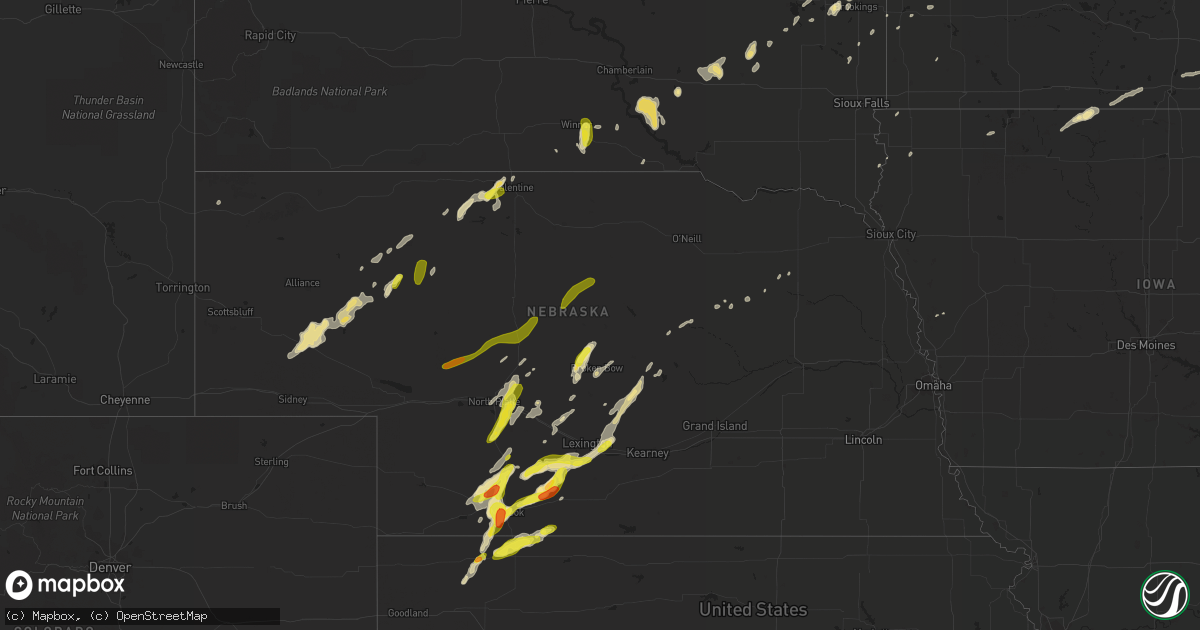
Hail Map in Nebraska on September 5, 2016
Get this storm
September 5 map
$229
one time, instant access
Download today. No call, no setup
Keep the $229
Bought the map and want the full workflow? Apply the entire $229 to a subscription within 7 days. None of it is wasted.
Every map, not just this one
This buys you this map. Subscription and you get every map we run, in the markets you choose from a few cities to whole states to nationwide. Plus real-time alerts the moment a storm fires.
Contact data
Name, contact info, occupancy, even credit band for addresses in the footprint. You go from where it hit to who to call.
Become the source they trust
Unlimited branding weather history reports on demand. You already have the documented answer ready for the property owner, and you are the one who showed up with it.
Property data and RoofTrace estimates
Pull up any address you have got, its value and the exact code rules for that jurisdiction, straight from One Click Code. Then RoofTrace estimates the squares, pitch, and roof value, priced the way you price.
Storm reports in Nebraska
Nebraska
| Date | Description |
|---|---|
| 09/05/20166:55 PM CDT | Hail ranged from pea to quarter size. Strong winds moved metal patio furniture around |
| 09/05/20166:45 PM CDT | A local report indicates 60 MPH wind near 14 ESE HAYES CENTER |
| 09/05/20166:20 PM CDT | A local report indicates 1.75 inch wind near 2 W MCCOOK |
| 09/05/20166:20 PM CDT | Pea to shooter marble size hail. Hail was very brief. |
| 09/04/20169:24 PM CDT | Time estimated...quarter size hail. |
| 09/04/20169:18 PM CDT | Hail was mostly pea size in nature...but a few nickel and quarter size pieces were observed. |
| 09/04/20169:02 PM CDT | A local report indicates 1.00 inch wind near 3 W MAXWELL |
| 09/04/20168:55 PM CDT | A local report indicates 1.00 inch wind near S NORTH PLATTE |
| 09/04/20168:45 PM CDT | Trees bending over from the wind. Pea size hail also reported |
| 09/04/20168:44 PM CDT | Wind gusts to 55 mph. |
| 09/04/20168:23 PM CDT | Lots of pea size hail... But a few stones to the size of quarters. |
| 09/04/20168:15 PM CDT | A local report indicates 1.50 inch wind near 21 SE CURTIS |
| 09/04/20168:06 PM CDT | A local report indicates 1.75 inch wind near 21 SE CURTIS |
| 09/04/20167:51 PM CDT | A local report indicates 1.00 inch wind near 21 SSE CURTIS |
| 09/04/20167:50 PM CDT | Also est winds to 50 mph and measured rainfall of 0.90 in. |
| 09/04/20167:49 PM CDT | Hail is still falling... Could hear it over the phone. Corrected for location error. |
| 09/04/20167:49 PM CDT | Hail is still falling... Could hear it over the phone. |
| 09/04/20167:45 PM CDT | Hail is falling now... Could hear it over the phone. |
| 09/04/20167:05 PM CDT | A local report indicates 1.00 inch wind near MCCOOK |
All States Impacted by Hail Map on September 5, 2016
Cities Impacted by Hail Map on September 5, 2016
- Culbertson, NE
- Drummond, WI
- Solon Springs, WI
- Gordon, WI
- Isabella, MN
- Isanti, MN
- Howard, SD
- Carthage, SD
- Grand Portage, MN
- Grand Marais, MN
- Hovland, MN
- Wellfleet, NE
- Brady, NE
- Maxwell, NE
- North Platte, NE
- Stapleton, NE
- Echo, MN
- Bartley, NE
- Moorefield, NE
- Eustis, NE
- Winter, WI
- Chetek, WI
- Broadwater, NE
- Bridgeport, NE
- Lisco, NE
- Wayzata, MN
- Glenwood City, WI
- Shell Lake, WI
- Iron Belt, WI
- Wakefield, MI
- Rice Lake, WI
- Birchwood, WI
- Mikana, WI
- Dassel, MN
- Newell, SD
- Grand Rapids, MN
- Barron, WI
- Aladdin, WY
- Hulett, WY
- Wagon Mound, NM
- Cumberland, WI
- Frederic, WI
- Florence, WI
- Long Lake, WI
- Belle Fourche, SD
- Gibbon, MN
- Iron River, MI
- Elk River, MN
- Minneapolis, MN
- Saint Paul, MN
- Cable, WI
- Hayward, WI
- Winner, SD
- Colome, SD
- Plankinton, SD
- Ghent, MN
- Hayes Center, NE
- Maywood, NE
- Curtis, NE
- McCook, NE
- Meadowlands, MN
- Floodwood, MN
- Cozad, NE
- Kimball, SD
- Platte, SD
- Hutchinson, MN
- Cosmos, MN
- Buffalo Lake, MN
- Litchfield, MN
- Fedora, SD
- Gaastra, MI
- Boise City, OK
- Kenton, OK
- Dallas, WI
- Prairie Farm, WI
- Jacobson, MN
- Somerset, WI
- Ladysmith, WI
- Kennan, WI
- Valentine, NE
- Virginia, MN
- Eveleth, MN
- Hector, MN
- Corona, NM
- Forbes, MN
- Faith, SD
- Merna, NE
- Mount Vernon, SD
- Tofte, MN
- Verndale, MN
- Wadena, MN
- Sheldon, WI
- Glen Flora, WI
- Renville, MN
- Sacred Heart, MN
- Ellsworth, NE
- Meadow, SD
- Mud Butte, SD
- Atwood, KS
- Union Center, SD
- Devils Tower, WY
- Herndon, KS
- Elwood, NE
- Sarona, WI
- Pelican Rapids, MN
- Lake Park, MN
- Audubon, MN
- Volga, SD
- Arlington, SD
- Clam Lake, WI
- Glidden, WI
- Alcester, SD
- Boulder Junction, WI
- Woodruff, WI
- Manitowish Waters, WI
- Fifield, WI
- Oberlin, KS
- Lebanon, NE
- Bruce, WI
- Mellen, WI
- Marengo, WI
- Clayton, WI
- Almena, WI
- Turtle Lake, WI
- Hoyt Lakes, MN
- Conrath, WI
- Mercer, WI
- Lac Du Flambeau, WI
- Park Falls, WI
- Balsam Lake, WI
- Land O'Lakes, WI
- Conover, WI
- White Lake, SD
- Monticello, MN
- Overton, NE
- Stockville, NE
- Farnam, NE
- Lexington, NE
- Indianola, NE
- Smithfield, NE
- Elm Creek, NE
- Ashby, NE
- Sundance, WY
- Kilgore, NE
- Crookston, NE
- Oldham, SD
- Felt, OK
- Stewart, MN
- Tomahawk, WI
- Callaway, NE
- New Prague, MN
- Hudson, SD
- Boyceville, WI
- Menomonie, WI
- Colfax, WI
- Dallas, SD
- Bertrand, NE
- Arnold, NE
- Saint Francis, MN
- Zimmerman, MN
- Hopkins, MN
- Barnesville, MN
- Sabin, MN
- Artesian, SD
- Litchfield, NE
- Mason City, NE
- Bonesteel, SD
- Saint Charles, SD
- Loup City, NE
- Astoria, SD
- New Auburn, WI
- Letcher, SD
- Ord, NE
- Gilbert, MN
- Biwabik, MN
- Aurora, MN
- Iron, MN
- Mountain Iron, MN
- Saint Onge, SD
- Nisland, SD
- Spearfish, SD
- Vale, SD
- Hastings, MN
- Bird Island, MN
- Center City, MN
- Shafer, MN
- Prescott, WI
- Granite Falls, MN
- Phelps, WI
- Sparta, WI
- Ridgeland, WI
- Wheeler, WI
- Downing, WI
- Miller, NE
- Sumner, NE
- Howard Lake, MN
- Gothenburg, NE
- Milroy, MN
- Belview, MN
- Wilsonville, NE
- Norcatur, KS
- Danbury, NE
- Alto, TX
- Merriman, NE
- Bedias, TX
- Warba, MN
- Bovey, MN
- Rothsay, MN
- Jordan, MN
- Prior Lake, MN
- Le Center, MN
- Sioux Center, IA
- Hull, IA
- Naples, FL
- Eagle River, WI
- Sayner, WI
- Star Lake, WI
- Hill City, MN
- High Bridge, WI
- Champlin, MN
- Osseo, MN
- Enning, SD
- Olivia, MN
- Redwood Falls, MN
- Brookings, SD
- Aurora, SD
- Holbrook, NE
- Baldwin, WI
- Woodville, WI
- Barronett, WI
- Elmwood, WI
- Spring Valley, WI
- Hampton, MN
- Danbury, WI
- Burke, SD
- Gregory, SD
- Marshall, MN
- Dayton, MN
- Anoka, MN
- Knapp, WI
- Dell Rapids, SD
- Colman, SD
- Grantsburg, WI
- Broken Bow, NE
- Flandreau, SD
- Taconite, MN
- Ledyard, IA
- Swea City, IA
- Armstrong, IA
- Vesta, MN
- Clayton, NM
- Stillwater, MN
- Hugo, MN
- Marine On Saint Croix, MN
- North Zulch, TX
- Alden, MN
- Wells, MN
- Frost, MN
- Elmore, MN
- Bricelyn, MN
- Weyerhaeuser, WI
- Cedar, MN
- Bethel, MN
- Republic, MI
- Watersmeet, MI
- Rhinelander, WI
- Phillips, WI
- Savage, MN
- Shakopee, MN
- Lake Benton, MN
- Egan, SD
- Taylors Falls, MN
- Belle Plaine, MN
- Princeton, MN
- Hammond, WI
- New Richmond, WI
- Normangee, TX
- Horace, ND
- Wolverton, MN
- Walcott, ND
- Christine, ND
- Kindred, ND
- Comstock, MN
- Moorhead, MN
- Champion, MI
- Taunton, MN
- Porter, MN
- Ivanhoe, MN
- Crystal Falls, MI
- Caspian, MI
- Big Lake, MN
- Alva, FL
- Ludell, KS
- Oshkosh, NE
- Hudson, WI
- River Falls, WI
- Roberts, WI
- Cohasset, MN
- Coleraine, MN
- Butternut, WI
- Hawkins, WI
- Canyon, MN
- Willow Island, NE
- Pengilly, MN
- Anselmo, NE
- Chaska, MN
- Cologne, MN
- Carver, MN
- Lake Preston, SD
- Pipestone, MN
- Duluth, MN
- Cotton, MN
- Ramona, SD
- Ocate, NM
- Whitman, NE
- Cokato, MN
- Everly, IA
- Milford, IA
- Brownsdale, MN
- Harshaw, WI
- Hazelhurst, WI
- Comstock, WI
- Sturgis, SD
- Whitewood, SD
- Moorhead, IA
- Pisgah, IA
- Scotia, NE
- Ericson, NE
- Grand Meadow, MN
- Harris, MN
- Saint Croix Falls, WI
- Wilson, WI
- Grapeland, TX
- Bingham, NE
- Hendricks, MN
- Tony, WI
- Minnetonka, MN
- Grand Marais, MI
- White, SD
- Tilden, NE
- Meadow Grove, NE
- Ansley, NE
- Westerville, NE
- Nashwauk, MN
- Hibbing, MN
- Keewatin, MN
- Elgin, NE
- Oakdale, NE
- Brownton, MN
- Glencoe, MN
- Bruce, SD
- Chisholm, MN
- Brimson, MN
- Buhl, MN
- Kinney, MN
- Babbitt, MN
- Arcadia, NE
- Swan River, MN
- Goodland, MN
- Gary, SD
- Canby, MN
- Lynd, MN
- Brandt, SD
- Darwin, MN
- Harrison, NE
- Clarkfield, MN
- Minneota, MN
- Hanley Falls, MN
- Fulton, SD
- Circle Pines, MN
- Lake Elmo, MN
- White Pine, MI
- Ontonagon, MI
- Sinai, SD
- Lindstrom, MN
- North Branch, MN
- Holcombe, WI
- Las Vegas, NM
- Pierce, NE
- Buffalo, MN
- Ringsted, IA
- Toronto, SD
- Stacy, MN
- Cambridge, MN
- Saint Michael, MN
- Albertville, MN
- Austin, MN
- Dexter, MN
- Rock Rapids, IA
- Larchwood, IA
- Ewen, MI
- Silver Lake, MN
- Winsted, MN
- Waverly, MN
- Hyannis, NE
- Tyler, MN
- Cambridge, NE
- Oconto, NE
- Palisade, NE
- Cody, NE
- Wood Lake, MN
- Sapello, NM
- Crockett, TX
- Blooming Prairie, MN
- Hollandale, MN
- Saint Paul Park, MN
- Newport, MN
- Farmington, MN
- Lakeville, MN
- Inver Grove Heights, MN
- Burnsville, MN
- Rosemount, MN
- Elko New Market, MN
- Cottage Grove, MN
- Fairfax, MN
- Chandler, MN
- Chisago City, MN
- Forest Lake, MN
- Scandia, MN
- Labelle, FL
- Afton, MN
- Lakeland, MN
- Paradise, MI
- Andover, MN
- Annandale, MN
- Bruce Crossing, MI
- Russell, MN
- Hamel, MN
- Loretto, MN
- Rogers, MN
- Rockford, MN
- Maple Grove, MN
- Pine River, MN
- Gilman, WI
- Rusk, TX
- Clear Lake, WI
- Reklaw, TX
- Jacksonville, TX
- Billings, MT
- Dawson, MN
- Petersburg, NE
- Upson, WI
- Tryon, NE
- Halsey, NE
- Sutherland, NE
- Purdum, NE
- Ainsworth, NE
- Brewster, NE


