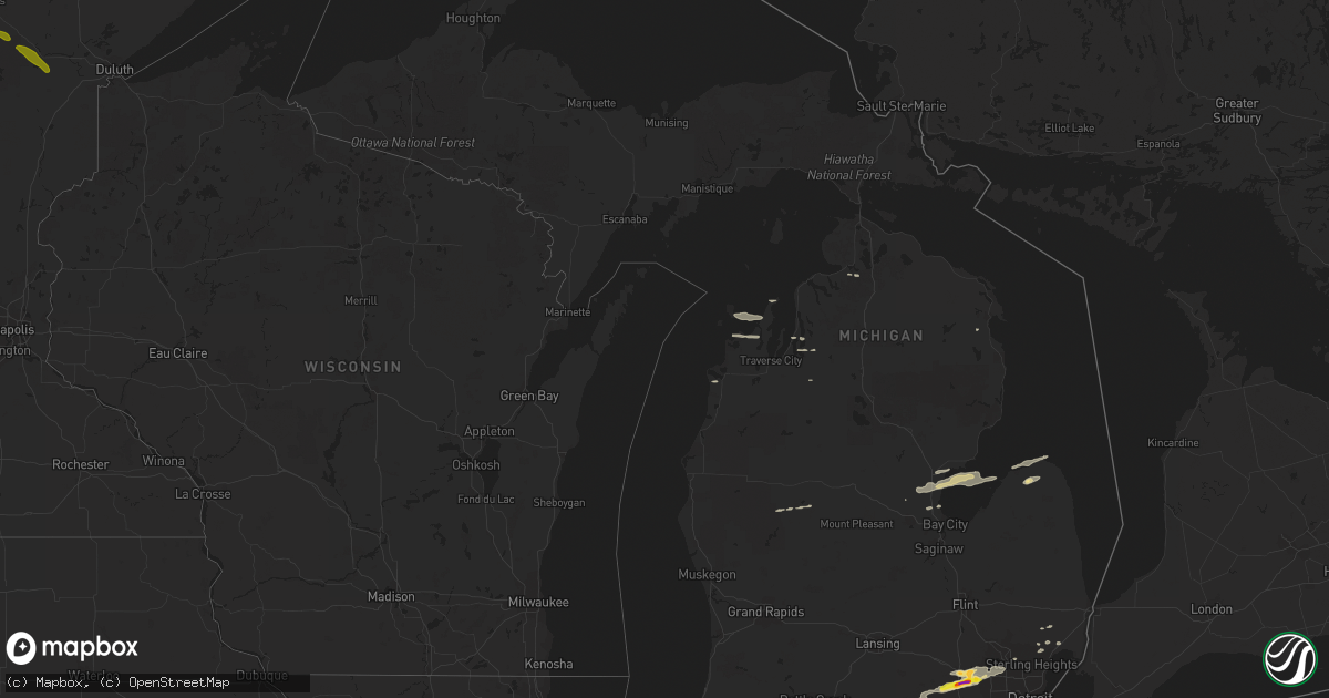
Hail Map in Michigan on September 4, 2017
Get this storm
September 4 map
$229
one time, instant access
Download today. No call, no setup
Keep the $229
Bought the map and want the full workflow? Apply the entire $229 to a subscription within 7 days. None of it is wasted.
Every map, not just this one
This buys you this map. Subscription and you get every map we run, in the markets you choose from a few cities to whole states to nationwide. Plus real-time alerts the moment a storm fires.
Contact data
Name, contact info, occupancy, even credit band for addresses in the footprint. You go from where it hit to who to call.
Become the source they trust
Unlimited branding weather history reports on demand. You already have the documented answer ready for the property owner, and you are the one who showed up with it.
Property data and RoofTrace estimates
Pull up any address you have got, its value and the exact code rules for that jurisdiction, straight from One Click Code. Then RoofTrace estimates the squares, pitch, and roof value, priced the way you price.
Storm reports in Michigan
Michigan
| Date | Description |
|---|---|
| 09/04/20175:50 PM CDT | Dime to quarter size hail reported |
| 09/04/20174:37 PM CDT | Verified via photo of 2 inch size hail |
| 09/04/20174:35 PM CDT | A local report indicates 1.00 inch wind near 2 ENE WHITMORE LAKE |
| 09/04/20174:30 PM CDT | A local report indicates 1.00 inch wind near 5 ESE PINCKNEY |
| 09/04/20174:30 PM CDT | Report of power pole blown over and 3 inch tree limbs down |
| 09/04/20174:30 PM CDT | Received photo verifying half dollar sized hail |
| 09/04/20171:27 PM CDT | A local report indicates 1.00 inch wind near PINCONNING |
All States Impacted by Hail Map on September 4, 2017
Cities Impacted by Hail Map on September 4, 2017
- Gillespie, IL
- Mount Olive, IL
- Livingston, IL
- Litchfield, IL
- Benld, IL
- Staunton, IL
- Worden, IL
- Sawyerville, IL
- Wilsonville, IL
- Shipman, IL
- New Douglas, IL
- Bunker Hill, IL
- Carlinville, IL
- Palmyra, IL
- Waggoner, IL
- Girard, IL
- Mayer, AZ
- Kevil, KY
- Belle Rive, IL
- Dahlgren, IL
- Keenes, IL
- McLeansboro, IL
- Bluford, IL
- Wayne City, IL
- South Lyon, MI
- Wolcottville, IN
- Russiaville, IN
- Reynolds, IN
- Battle Ground, IN
- Cutler, IN
- Flora, IN
- Lafayette, IN
- Michigantown, IN
- Kokomo, IN
- Frankfort, IN
- Bringhurst, IN
- Rossville, IN
- Remington, IN
- Brookston, IN
- Goodland, IN
- Delphi, IN
- Burlington, IN
- Monticello, IN
- Chalmers, IN
- Forest, IN
- West Lafayette, IN
- Wolcott, IN
- Decatur, IL
- Winamac, IN
- Fredericktown, MO
- Galion, OH
- Filion, MI
- Dorsey, IL
- Edwardsville, IL
- Moro, IL
- Labadie, MO
- Pacific, MO
- Chesterfield, MO
- Eureka, MO
- Saint Albans, MO
- Catawissa, MO
- Augusta, MO
- Saint Charles, MO
- Defiance, MO
- Wildwood, MO
- Cedar Hill, MO
- House Springs, MO
- Davisville, MO
- Covington, OH
- Bradford, OH
- Columbia, IL
- Belleville, MI
- Ypsilanti, MI
- Liberty, IN
- Camden, OH
- Oxford, OH
- Somerville, OH
- College Corner, OH
- West College Corner, IN
- Russell, PA
- Warren, PA
- Sugar Grove, PA
- Cromwell, IN
- Waterford, PA
- Cambridge Springs, PA
- Union City, PA
- Holts Summit, MO
- Jefferson City, MO
- Sullivan, MO
- Perryville, MO
- Macomb, MI
- Collinsville, IL
- Cottage Hills, IL
- South Roxana, IL
- Hartford, IL
- Belleville, IL
- Roxana, IL
- Granite City, IL
- Nilwood, IL
- Wood River, IL
- Scott Air Force Base, IL
- Highland, IL
- Chesterfield, IL
- East Alton, IL
- Bethalto, IL
- Lebanon, IL
- Summerfield, IL
- Hamel, IL
- Piasa, IL
- Sorento, IL
- Marine, IL
- Walshville, IL
- Glen Carbon, IL
- Mascoutah, IL
- Caseyville, IL
- Godfrey, IL
- Maryville, IL
- Saint Louis, MO
- Hettick, IL
- Greenfield, IL
- New Baden, IL
- Alhambra, IL
- Saint Jacob, IL
- Alton, IL
- Brighton, IL
- Rockbridge, IL
- Medora, IL
- Trenton, IL
- Fairview Heights, IL
- Troy, IL
- Roodhouse, IL
- O'Fallon, IL
- Taylorville, IL
- Dalton City, IL
- Argenta, IL
- Lovington, IL
- Mt Zion, IL
- Sainte Genevieve, MO
- Hagerstown, IN
- Greens Fork, IN
- Mooreland, IN
- Economy, IN
- New Castle, IN
- Losantville, IN
- Williamsburg, IN
- Saint Mary, MO
- Karnak, IL
- Centerville, PA
- New Riegel, OH
- McCutchenville, OH
- Carey, OH
- Waverly, IL
- Marion, IL
- Milford, MI
- Whitmore Lake, MI
- Northville, MI
- Wixom, MI
- Novi, MI
- New Hudson, MI
- Brighton, MI
- Dexter, MI
- Potosi, MO
- Equality, IL
- Junction, IL
- Ridgway, IL
- Eldorado, IL
- Metropolis, IL
- Belknap, IL
- Crown City, OH
- Gallipolis, OH
- Black, MO
- Mount Lemmon, AZ
- Leesburg, OH
- Erie, PA
- Wattsburg, PA
- Arlington, OH
- Mount Blanchard, OH
- Wharton, OH
- Caledonia, OH
- Bucyrus, OH
- Nevada, OH
- Forest, OH
- Dunkirk, OH
- Harpster, OH
- Sycamore, OH
- Upper Sandusky, OH
- Kirby, OH
- South Boardman, MI
- Grubville, MO
- Dittmer, MO
- California, KY
- Moscow, OH
- Cadet, MO
- Blackwell, MO
- Fletcher, MO
- Kingman, AZ
- Maple City, MI
- Cedar, MI
- Lake Leelanau, MI
- Bismarck, IL
- Williamsport, IN
- Danville, IL
- Covington, IN
- State Line, IN
- Cave In Rock, IL
- Marion, KY
- La Center, KY
- Broughton, IL
- Cub Run, KY
- Mammoth Cave, KY
- Francesville, IN
- Monon, IN
- Rensselaer, IN
- Star City, IN
- Harlan, IN
- Hicksville, OH
- Antwerp, OH
- Mounds, IL
- Villa Ridge, IL
- New Richmond, IN
- Kentland, IN
- Scottown, OH
- Patriot, OH
- Willow Wood, OH
- Pedro, OH
- Oreana, IL
- Forsyth, IL
- Warrensburg, IL
- Armada, MI
- Richmond, MI
- Mineral Point, MO
- Thompsonville, IL
- Benton, IL
- Logan, IL
- West Frankfort, IL
- Solway, MN
- Gregory, MI
- Ann Arbor, MI
- Walled Lake, MI
- Franklin, MI
- Grass Lake, MI
- Hamburg, MI
- Chelsea, MI
- Farmington, MI
- Pinckney, MI
- Bloomfield Hills, MI
- Commerce Township, MI
- West Bloomfield, MI
- Manchester, MI
- Syracuse, IN
- Anderson, IN
- Muncie, IN
- Yorktown, IN
- Alexandria, IN
- Daleville, IN
- Celina, OH
- De Soto, MO
- Sherwood, OH
- Globe, AZ
- Miami, AZ
- Rodney, MI
- Barryton, MI
- Carlyle, IL
- Mulberry, IN
- Clarks Hill, IN
- Sidney, OH
- Tamms, IL
- Barlow, KY
- Olmsted, IL
- Nevis, MN
- Park Rapids, MN
- Nashville, IL
- Addieville, IL
- Okawville, IL
- Thomasboro, IL
- Gifford, IL
- Penfield, IL
- Norris City, IL
- Omaha, IL
- Whitleyville, TN
- Medaryville, IN
- Oregonia, OH
- Lebanon, OH
- Lima, OH
- Cairo, OH
- Columbus Grove, OH
- Tolono, IL
- Bryan, OH
- Edgerton, OH
- Bloomville, OH
- Attica, OH
- Lake Saint Louis, MO
- Robertsville, MO
- Hawk Point, MO
- Marthasville, MO
- Villa Ridge, MO
- Moscow Mills, MO
- Gray Summit, MO
- O'Fallon, MO
- Foristell, MO
- Wentzville, MO
- Saint Peters, MO
- Troy, MO
- High Ridge, MO
- Washington, MO
- Wright City, MO
- Ballwin, MO
- Old Monroe, MO
- Bourbon, MO
- Richwoods, MO
- Scott City, MO
- Thebes, IL
- Olive Branch, IL
- Rapid City, MI
- Alden, MI
- Marion, IN
- Sand Creek, MI
- Fort Wayne, IN
- Yoder, IN
- Hoagland, IN
- Harbor View, OH
- Toledo, OH
- Oregon, OH
- Jasper, MI
- Blissfield, MI
- Berkey, OH
- Metamora, OH
- Morgantown, KY
- Kempton, IN
- West Alexandria, OH
- Eaton, OH
- Deshler, OH
- Hamler, OH
- Paducah, KY
- Wapakoneta, OH
- Crown King, AZ
- Avilla, IN
- Rhodes, MI
- Pigeon, MI
- Pinconning, MI
- Hillsboro, MO
- Festus, MO
- Attica, IN
- Farmington, MO
- Kirklin, IN
- Sheridan, IN
- Atlanta, IN
- Tipton, IN
- Hudson, MI
- Osseo, MI
- Pittsford, MI
- Galatia, IL
- Bemus Point, NY
- Crestline, OH
- Shelby, OH
- Mansfield, OH
- Richview, IL
- Jonesboro, IL
- Anna, IL
- Seligman, AZ
- Ash Fork, AZ
- Standish, MI
- Keystone, IN
- Montpelier, IN
- Poneto, IN
- Bowling Green, IN
- Converse, IN
- Greentown, IN
- Pittsfield, PA
- Jamestown, NY
- Frewsburg, NY
- Youngsville, PA
- Murrayville, IL
- Jacksonville, IL
- Woodson, IL
- Franklin, IL
- Modesto, IL
- Chillicothe, OH
- Mason, OH
- Centralia, IL
- Hoyleton, IL
- Daisy, MO
- Sedgewickville, MO
- Friedheim, MO
- Pittsburg, IL
- Harrisburg, IL
- Carrier Mills, IL
- Aviston, IL
- Breese, IL
- Rushville, IN
- Lewisville, IN
- Falmouth, IN
- Iberia, MO
- Macon, IL
- Blue Mound, IL
- Boody, IL
- Niantic, IL
- Harristown, IL
- West Chester, OH
- Middletown, OH
- Hamilton, OH
- Etna Green, IN
- Mound City, IL
- Cairo, IL
- West Paducah, KY
- Tucson, AZ
- Hamilton, IN
- Edon, OH
- Hanover, MI
- Clarklake, MI
- Horton, MI
- Big Rapids, MI
- Tennyson, IN
- Gentryville, IN
- Elwood, IN
- Pocahontas, IL
- Beckemeyer, IL
- Bartelso, IL
- Hoffman, IL
- Homer, IL
- Linwood, MI
- Kawkawlin, MI
- Bethel, OH
- Hamersville, OH
- Gosport, IN
- Ellettsville, IN
- Spencer, IN
- Jonesville, MI
- Litchfield, MI
- Homer, MI
- Napoleon, OH
- Defiance, OH
- Holgate, OH
- Albion, PA
- Edinboro, PA
- Springboro, PA
- Glenallen, MO
- Patton, MO
- Marquand, MO
- Marble Hill, MO
- Bronson, MI
- Sharpsville, IN
- Saegertown, PA
- Conneautville, PA
- Sesser, IL
- Ina, IL
- Waltonville, IL
- Scheller, IL
- Whittington, IL
- Leipsic, OH
- Continental, OH
- New Bavaria, OH
- Waterloo, IL
- Straughn, IN
- Richmond, IN
- Milton, IN
- Cambridge City, IN
- Centerville, IN
- Springport, IN
- Mount Vernon, IL
- Ironton, MO
- Arcadia, MO
- Churubusco, IN
- Columbia City, IN
- Saint Marys, OH
- Greenwood, IN
- Frankton, IN
- Modoc, IN
- Lapel, IN
- Noblesville, IN
- Middletown, IN
- Fountain City, IN
- Fairmount, IL
- Smiths Grove, KY
- Golconda, IL
- Prescott, AZ
- Milford, IN
- Pleasant Lake, IN
- Topeka, IN
- Hudson, IN
- Lagrange, IN
- Warrenton, MO
- Peebles, OH
- Seaman, OH
- Woodburn, IN
- New Haven, IN
- Grabill, IN
- Ney, OH
- Bourbon, IN
- Paulding, OH
- Latty, OH
- Payne, OH
- Melrose, OH
- Oakwood, OH
- Lynnville, IN
- Franklinville, NY
- Bainbridge, OH
- Hillsboro, OH
- Bement, IL
- Monticello, IL
- Riga, MI
- Adrian, MI
- Ottawa Lake, MI
- Temperance, MI
- Morenci, MI
- Lyons, OH
- Sylvania, OH
- Lambertville, MI
- Erie, MI
- Wawaka, IN
- Rome City, IN
- Goshen, IN
- Wickenburg, AZ
- Findlay, OH
- Grantsburg, IL
- Ottawa, OH
- Chaffee, MO
- Curtice, OH
- Canton, MI
- Coldwater, MI
- Quincy, MI
- Mount Auburn, IL
- Edinburg, IL
- Montpelier, OH
- Tippecanoe, IN
- Argos, IN
- Ava, IL
- Redford, MO
- Ellington, MO
- Lesterville, MO
- Tiffin, OH
- Raleigh, IL
- Fort Jennings, OH
- Vaughnsville, OH
- Gomer, OH
- Willis, MI
- Armstrong, IL
- Nappanee, IN
- Hillsdale, MI
- Ashville, NY
- White Hall, IL
- Saint George, UT
- Cecil, OH
- Mark Center, OH
- Puposky, MN
- Ray, MI
- New Haven, MI
- Roundhill, KY
- Fairmount, IN
- Petoskey, MI
- Convoy, OH
- Van Wert, OH
- Monroeville, IN
- Annapolis, MO
- Silex, MO
- Bismarck, MO
- Irondale, MO
- Sweeden, KY
- Brownsville, KY
- Bee Spring, KY
- Connersville, IN
- Meadville, PA
- Spring Creek, PA
- Conneaut, OH
- Townville, PA
- Pierpont, OH
- Tidioute, PA
- Guys Mills, PA
- Corry, PA
- Grand Valley, PA
- Spartansburg, PA
- Titusville, PA
- Venango, PA
- Alvada, OH
- Vanlue, OH
- Cannelton, IN
- Leopold, IN
- Chatham, IL
- Springfield, IL
- Martinsville, IN
- Paragon, IN
- Cloverdale, OH
- Camp Verde, AZ
- Hope, MI
- Brownsville, IN
- Veedersburg, IN
- Alpena, MI
- Kinde, MI
- Elkton, MI
- Jerseyville, IL
- Jackson, MI
- South Salem, OH
- Williamstown, OH
- Stonefort, IL
- Wheelersburg, OH
- Ulman, MO
- Morrow, OH
- Pleasant Plain, OH
- Tuscumbia, MO
- New Baltimore, MI
- Addison, MI
- North Adams, MI
- Morral, OH
- Jenera, OH
- Tiro, OH
- Dola, OH
- Marion, OH
- Ada, OH
- Kane, IL
- Macedonia, IL
- Shipshewana, IN
- Middlebury, IN
- Kendallville, IN
- Albion, IN
- Murphysboro, IL
- Glasgow, KY
- Windfall, IN
- Swayzee, IN
- Centerpoint, IN
- Clay City, IN
- Frankfort, OH
- Greenfield, OH
- Bloomington, IN
- Frankfort, MI
- Red Bud, IL
- Evansport, OH
- Stryker, OH
- Northport, MI
- Decatur, IN
- Huntertown, IN
- Howe, IN
- Sturgis, MI
- Burr Oak, MI
- Dale, IL
- Troy, MI
- Bargersville, IN
- Franklin, IN
- Stonington, IL
- Mays, IN
- Goldsmith, IN
- Spiceland, IN
- Buck Creek, IN
- Markleville, IN
- Pendleton, IN
- Fowler, IN
- Carthage, IN
- Camden, IN
- Cicero, IN
- Knightstown, IN
- Shirley, IN
- Arcadia, IN
- Johnston City, IL
- Herrin, IL
- Creal Springs, IL
- Belgrade, MO
- Elk Rapids, MI
- Tell City, IN
- Chrisman, IL
- McKean, PA
- Girard, PA
- Cranesville, PA
- Congress, AZ
- Clayton, MI
- Holland, OH
- Swanton, OH
- Poland, IN
- Loami, IL
- Pioneer, OH
- Saline, MI
- McComb, OH
- Midland, OH
- Clarksville, OH
- Fayetteville, OH
- Goshen, OH
- Martinsville, OH
- Lynchburg, OH
- Blanchester, OH
- New Vienna, OH
- Morristown, AZ
- Plymouth, OH
- Shiloh, OH
- New Washington, OH
- Woodlawn, IL
- Ashley, IL
- Coldwater, OH
- Middle Brook, MO
- Hammond, IL
- Cerro Gordo, IL
- Limestone, NY
- Tiline, KY
- Quincy, IN
- Cloverdale, IN
- Eldon, MO
- Russellville, MO
- Lohman, MO
- Pawnee, IL
- Rochester, IL
- Pulaski, IL
- Brookport, IL
- Grand Chain, IL
- Leland, MI
- Empire, MI
- Culver, IN
- Sidney, IL
- Philo, IL
- Georgetown, OH
- Reading, MI
- Allen, MI
- Spencerville, OH
- Delphos, OH
- Petroleum, IN
- Bluffton, IN
- Canal Fulton, OH
- North Lawrence, OH
- Clinton, OH
- Marshallville, OH
- Winchester, IL
- Hillview, IL
- Butler, KY
- Fletcher, OH
- Casstown, OH
- Conover, OH
- North Canton, OH
- Massillon, OH
- Mechanicsburg, IL
- Portsmouth, OH
- Rittman, OH
- Sterling, OH
- Bath, IN
- Roachdale, IN
- Opdyke, IL
- Lucerne, IN
- Royal Center, IN
- New Florence, MO
- Port Austin, MI
- Saint Meinrad, IN
- Bristow, IN
- North Liberty, IN
- Colon, MI
- Menahga, MN
- Salamanca, NY
- Columbus, PA
- Bear Lake, PA
- Bluffton, OH
- Pandora, OH
- Belleview, MO
- Caledonia, MO
- Peach Springs, AZ
- Westpoint, IN
- Sadorus, IL
- Springerton, IL
- Sabina, OH
- Wilmington, OH
- Grand Rapids, MN
- Cohasset, MN
- Warba, MN
- Swan River, MN
- Jacobson, MN
- Floodwood, MN
- Wright, MN
- Tenstrike, MN
- Bemidji, MN


