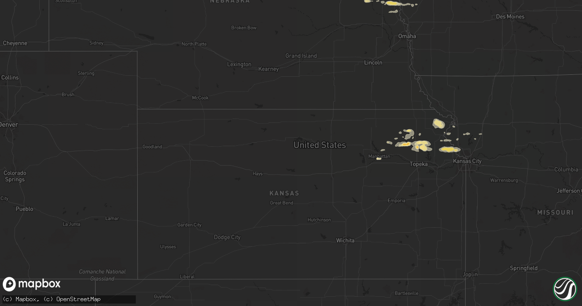
Hail Map in Kansas on September 3, 2012
Get this storm
September 3 map
$229
one time, instant access
Download today. No call, no setup
Keep the $229
Bought the map and want the full workflow? Apply the entire $229 to a subscription within 7 days. None of it is wasted.
Every map, not just this one
This buys you this map. Subscription and you get every map we run, in the markets you choose from a few cities to whole states to nationwide. Plus real-time alerts the moment a storm fires.
Contact data
Name, contact info, occupancy, even credit band for addresses in the footprint. You go from where it hit to who to call.
Become the source they trust
Unlimited branding weather history reports on demand. You already have the documented answer ready for the property owner, and you are the one who showed up with it.
Property data and RoofTrace estimates
Pull up any address you have got, its value and the exact code rules for that jurisdiction, straight from One Click Code. Then RoofTrace estimates the squares, pitch, and roof value, priced the way you price.
Storm reports in Kansas
Kansas
| Date | Description |
|---|---|
| 09/03/20126:38 PM CDT | Delayed report from the public of the morton steel building damaged along with lines and signs down near the railroad crossing and 26th avenue. |
| 09/02/201211:00 PM CDT | Measured at the leavenworth courthouse. |
| 09/02/201211:00 PM CDT | 24 inch diameter tree along with several smaller trees down at 10th and chestnut. Tree fell on vehicle at 726 ottawa |
| 09/02/201210:36 PM CDT | 12 inch limb reported blown down from live tree. |
| 09/02/20129:57 PM CDT | Large gas grill was blown 20 feet into side of truck. Truck door and siding were damaged. The grill was then blown into the nearby field. Delayed report. |
| 09/02/20128:00 PM CDT | A local report indicates 1.00 inch wind near 4 S MANHATTAN |
All States Impacted by Hail Map on September 3, 2012
Cities Impacted by Hail Map on September 3, 2012
- Eutaw, AL
- Aliceville, AL
- Boligee, AL
- Reform, AL
- Gordo, AL
- Miller, SD
- West Point, NE
- Marion, AL
- Rock, MI
- Akron, AL
- Moundville, AL
- Epes, AL
- Emelle, AL
- Chaseley, ND
- Knoxville, AL
- Mayetta, KS
- Washburn, ND
- Savannah, GA
- Salem, SD
- Montrose, SD
- Louisville, MS
- Macon, MS
- Terril, IA
- Graettinger, IA
- Estherville, IA
- Vulcan, MI
- Goff, KS
- Wetmore, KS
- Gladstone, MI
- Rapid River, MI
- Sawyerville, AL
- Holabird, SD
- Blunt, SD
- Harrold, SD
- Pierre, SD
- Florence, WI
- Argonne, WI
- Fence, WI
- Long Lake, WI
- Plankinton, SD
- Foster City, MI
- Little Lake, MI
- Wallingford, IA
- Platte City, MO
- Leavenworth, KS
- Easton, KS
- Saint Lawrence, SD
- Ree Heights, SD
- Highmore, SD
- Wessington, SD
- Holton, KS
- Circleville, KS
- Cornell, MI
- Loretto, MI
- McColl, SC
- Bennettsville, SC
- Mount Vernon, SD
- Mitchell, SD
- Plantersville, AL
- Perkins, MI
- Emmett, KS
- Soldier, KS
- Delia, KS
- Woonsocket, SD
- Wessington Springs, SD
- Letcher, SD
- Roscoe, SD
- Denton, KS
- Bendena, KS
- Troy, KS
- Robinson, KS
- Cylinder, IA
- Whittemore, IA
- Hurdsfield, ND
- Harvey, ND
- Atchison, KS
- Ringsted, IA
- Saint David, AZ
- Wells, MI
- Escanaba, MI
- Hermansville, MI
- Camden Point, MO
- Dearborn, MO
- Oakland, NE
- Soldiers Grove, WI
- Rushville, MO
- De Kalb, MO
- Hardeeville, SC
- Spring Grove, MN
- Mabel, MN
- Lanesboro, MN
- Houston, MN
- Peterson, MN
- Lathrop, MO
- Woodbine, IA
- Havensville, KS
- Midway, AL
- Blair, NE
- Tekamah, NE
- Herman, NE
- Saint Joseph, MO
- Hoyt, KS
- Meriden, KS
- Valley Falls, KS
- Denison, KS
- Fort Leavenworth, KS
- McLouth, KS
- Kansas City, MO
- Winchester, KS
- Waldron, MO
- Lansing, KS
- Farley, MO
- Westmoreland, KS
- Onaga, KS
- Flagstaff, AZ
- Goodhue, MN
- Lake City, MN
- Greensboro, AL
- De Soto, WI
- Gower, MO
- Red Wing, MN
- Wetmore, MI
- Shingleton, MI
- Munising, MI
- Leary, GA
- Fort Stockton, TX
- White Lake, SD
- Manhattan, KS
- Beemer, NE
- Shuqualak, MS
- Athelstane, WI
- Independence, WI
- Mondovi, WI
- Spencer, SD
- Bassett, NE
- Long Pine, NE
- Saint George, KS
- Highland, KS
- Brooksville, MS
- Alpena, SD
- Stuart, NE
- Atkinson, NE
- Kimball, SD
- Ashley, ND
- Felch, MI
- Valley City, ND
- Wabeno, WI
- Laona, WI
- Craig, NE
- Champion, MI
- Ishpeming, MI
- Millport, AL
- Marion Junction, AL
- Uniontown, AL
- Newbern, AL
- Whiting, KS
- Canton, MN
- Little Sioux, IA
- Pisgah, IA
- Mondamin, IA
- Milford, IA
- Spirit Lake, IA
- Union Springs, AL
- New York Mills, MN
- Wilson, MI
- Carney, MI
- Powers, MI
- Corning, KS
- Claxton, GA
- Fredonia, ND
- Pembroke, GA
- Carrollton, AL
- Tuttle, ND
- Crandon, WI
- Bark River, MI
- Garden, MI
- Sebeka, MN
- Caledonia, MN
- Humboldt, SD
- Strasburg, ND
- Pembine, WI
- Denhoff, ND
- Engadine, MI
- Gould City, MI
- Curtis, MI
- Naubinway, MI
- Lakewood, WI
- Durand, WI
- Goodrich, ND
- Virgil, SD
- Oskaloosa, KS
- Nortonville, KS
- Ozawkie, KS
- Hague, ND
- Crawford, MS
- Albemarle, NC
- Pelican Lake, WI
- Ferryville, WI
- Gays Mills, WI
- Lancaster, KS
- Everest, KS
- Weston, MO
- Townley, AL
- Edgerton, MO
- Ralph, AL
- Fosters, AL
- Ethelsville, AL
- Hillsboro, WI
- Arlington, GA
- Ellendale, ND
- Bremen, AL
- Hayden, AL
- Nadeau, MI
- Niagara, WI
- Dorchester, IA
- Decorah, IA
- Starkville, MS
- Nahma, MI
- Sardis, AL
- Minter, AL
- Whitehall, WI
- Viroqua, WI
- Plattsburg, MO
- Holt, MO
- Pickerel, WI
- Selma, AL
- Buhl, AL
- Echola, AL
- Elrod, AL


