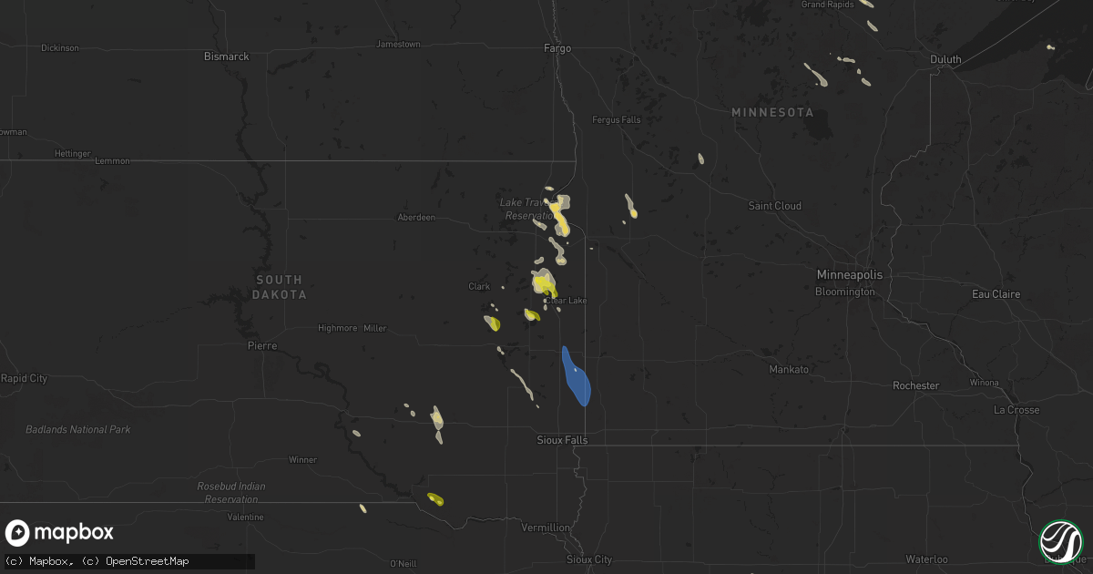
Hail Map on September 2, 2025
Get this storm
September 2 map
$229
one time, instant access
Download today. No call, no setup
Keep the $229
Bought the map and want the full workflow? Apply the entire $229 to a subscription within 7 days. None of it is wasted.
Every map, not just this one
This buys you this map. Subscription and you get every map we run, in the markets you choose from a few cities to whole states to nationwide. Plus real-time alerts the moment a storm fires.
Contact data
Name, contact info, occupancy, even credit band for addresses in the footprint. You go from where it hit to who to call.
Become the source they trust
Unlimited branding weather history reports on demand. You already have the documented answer ready for the property owner, and you are the one who showed up with it.
Property data and RoofTrace estimates
Pull up any address you have got, its value and the exact code rules for that jurisdiction, straight from One Click Code. Then RoofTrace estimates the squares, pitch, and roof value, priced the way you price.
States Impacted by Hail Map on September 2, 2025
Storm reports
South Dakota
| Date | Description |
|---|---|
| 09/02/20256:08 PM CDT | A local report indicates 1.00 inch wind near 3 E Hayti |
| 09/02/20255:05 PM CDT | Largest hail stones were the size of a quarter... But most were dime size. Lasted 5 to 10 minutes. |
| 09/01/20257:22 PM CDT | Thunderstorm wind gusts broke down a 3 inch diameter tree branch... Along with brief heavy rainfall. |
| 09/01/20257:15 PM CDT | A local report indicates 1.00 inch wind near Dante |
Kentucky
| Date | Description |
|---|---|
| 09/02/20253:29 PM CDT | The leslie county emergency operations center reported a downed tree just to the east of ky-80 in the wooton community. Time estimated via radar. |
Iowa
| Date | Description |
|---|---|
| 09/02/20256:50 AM CDT | A local report indicates 1.00 inch wind near 3 NE Yale |
Nevada
| Date | Description |
|---|---|
| 09/02/20256:48 PM CDT | Mesonet station wbknv 1.9 nw wabuska |
| 09/01/20259:47 PM CDT | Mesonet station mjbn2 majuba. |
| 09/01/20258:36 PM CDT | Mesonet station tornv 9.8 ne trinity junction |
| 09/01/20258:19 PM CDT | Mesonet station tounv 10.1 ne trinity junction |
| 09/01/20258:18 PM CDT | Mesonet station up993 3.2 e trinity junction |
California
| Date | Description |
|---|---|
| 09/02/202511:53 AM CDT | Large tree reported down across lanes at the intersection of gamble ave and van buren blvd. |
| 09/02/202510:30 AM CDT | Thunderstorm outflow wind gusts occurred across this region with gusts 50-60 mph. Highland springs station reported a gust to 72 mph. |
| 09/02/20259:50 AM CDT | Mesonet station 645se banning |
| 09/02/20258:58 AM CDT | Trained spotter recorded a wind gust of 58 mph from a nearby thunderstorm at 0658. |
Cities Impacted by Hail Map on September 2, 2025
- Sonora, CA
- Hopkinsville, KY
- Pembroke, KY
- Clarksville, TN
- Oak Grove, KY
- Dunmor, KY
- Belton, KY
- Magnolia, KY
- Herndon, KY
- Lewisburg, KY
- Bowling Green, KY
- Taylorsville, KY
- Coxs Creek, KY
- Oakland, KY
- Scottsville, KY
- Morris, MN
- Hancock, MN
- Crofton, KY
- Boston, KY
- Sisseton, SD
- Morgantown, KY
- Caneyville, KY
- Burkesville, KY
- Greenville, KY
- Holloway, MN
- Beardsley, MN
- Cadiz, KY
- Peever, SD
- Browns Valley, MN
- Edmonton, KY
- Summit, SD
- Breeding, KY
- Byrdstown, TN
- Wilmot, SD
- Corona, SD
- Clinton, MN
- Albany, KY
- Ortonville, MN
- Hyden, KY
- Milbank, SD
- Twin Brooks, SD
- Beech Creek, KY
- Marvin, SD
- Pall Mall, TN
- Indian Mound, TN
- Woodlawn, TN
- Wooton, KY
- Guerra, TX
- Cimarron, NM
- Stockholm, SD
- Ocate, NM
- South Shore, SD
- Watertown, SD
- Ute Park, NM
- Deer Lodge, TN
- Labolt, SD
- Eagle Nest, NM
- Clarkrange, TN
- Jamestown, TN
- Chamberlain, SD
- Goodwin, SD
- Sunbright, TN
- Pukwana, SD
- Platte, SD
- Kranzburg, SD
- Strandburg, SD
- Lancing, TN
- Clear Lake, SD
- Goodland, MN
- Letcher, SD
- Hibbing, MN
- Pengilly, MN
- Louisville, KY
- Fairdale, KY
- Willow Lake, SD
- Raton, NM
- Plankinton, SD
- White Lake, SD
- Mount Vernon, SD
- Naper, NE
- Brooks, KY
- Bryant, SD
- Vienna, SD
- Mitchell, SD
- De Smet, SD
- Hayti, SD
- Castlewood, SD
- Lake Norden, SD
- Floodwood, MN
- Estelline, SD
- Ethan, SD
- Maxwell, NE
- Emily, MN
- Lake Preston, SD
- Henry, SD
- Erwin, SD
- Palisade, MN
- Wagner, SD
- Mcgregor, MN
- Aurora, SD
- Brookings, SD
- Flandreau, SD
- Elkton, SD
- Ramona, SD
- Long Prairie, MN
- Carlos, MN
- Eagle Bend, MN
- Pipestone, MN
- Camptonville, CA
- Goodyears Bar, CA
- Madison, SD
- Tamarack, MN
- Osakis, MN
- Aitkin, MN
- Strawberry Valley, CA
- Trent, SD
- Garretson, SD
- Jasper, MN
- Dante, SD
- Kettle River, MN
- Egan, SD
- Bayfield, WI
- Nevada City, CA
- Somers, IA
- Gowrie, IA
- Farnhamville, IA
- Humphrey, AR
- Stuttgart, AR
- Bagley, IA
- Dana, IA
- Grand Junction, IA
- Jefferson, IA
- Dawson, IA
- Jamaica, IA
- Linden, IA
- Yale, IA
- De Witt, AR
- Panora, IA