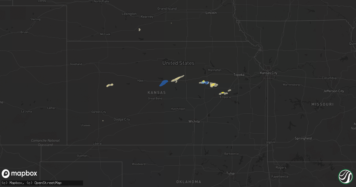
Hail Map in Kansas on September 2, 2021
Get this storm
September 2 map
$229
one time, instant access
Download today. No call, no setup
Keep the $229
Bought the map and want the full workflow? Apply the entire $229 to a subscription within 7 days. None of it is wasted.
Every map, not just this one
This buys you this map. Subscription and you get every map we run, in the markets you choose from a few cities to whole states to nationwide. Plus real-time alerts the moment a storm fires.
Contact data
Name, contact info, occupancy, even credit band for addresses in the footprint. You go from where it hit to who to call.
Become the source they trust
Unlimited branding weather history reports on demand. You already have the documented answer ready for the property owner, and you are the one who showed up with it.
Property data and RoofTrace estimates
Pull up any address you have got, its value and the exact code rules for that jurisdiction, straight from One Click Code. Then RoofTrace estimates the squares, pitch, and roof value, priced the way you price.
Storm reports in Kansas
Kansas
| Date | Description |
|---|---|
| 09/02/20216:11 PM CDT | 3-4 inch tree limbs down and dime and penny-sized hail. |
| 09/02/20215:16 PM CDT | A local report indicates 70 MPH wind near WILSON |
| 09/02/20214:11 AM CDT | At 911 PM CDT, a severe thunderstorm was located 4 miles east of Americus, moving east at 25 mph. HAZARD...60 mph wind gusts and quarter size hail. SOURCE...Radar indicated. IMPACT...Hail damage to vehicles is expected. Expect wind damage to roofs, siding, and trees. Locations impacted include... Emporia, Americus and Reading. This includes the following highways... Interstate 35 between mile markers 129 and 130, and between milemarkers 134 and 143. Kansas Turnpike between mile markers 129 and 142. |
| 09/02/20213:41 AM CDT | At 840 PM CDT, a severe thunderstorm was located near Americus, moving east at 25 mph. HAZARD...60 mph wind gusts and quarter size hail. SOURCE...Radar indicated. IMPACT...Hail damage to vehicles is expected. Expect wind damage to roofs, siding, and trees. Locations impacted include... Emporia and Americus. This includes the following highways... Interstate 35 between mile markers 128 and 136. Kansas Turnpike between mile markers 127 and 142. |
| 09/02/20212:44 AM CDT | At 744 PM CDT, a severe thunderstorm was located near Council Grove Lake, moving east at 25 mph. HAZARD...60 mph wind gusts and quarter size hail. SOURCE...Radar indicated. IMPACT...Hail damage to vehicles is expected. Expect wind damage to roofs, siding, and trees. Locations impacted include... Council Grove, Alta Vista and Council Grove Lake. |
| 09/02/20212:18 AM CDT | At 718 PM CDT, a severe thunderstorm was located near Parkerville, moving east at 25 mph. HAZARD...60 mph wind gusts and quarter size hail. SOURCE...Radar indicated. IMPACT...Hail damage to vehicles is expected. Expect wind damage to roofs, siding, and trees. Locations impacted include... Council Grove, White City, Alta Vista, Dwight, Parkerville and Council Grove Lake. |
| 09/02/20211:30 AM CDT | At 630 PM CDT, a severe thunderstorm was located near Woodbine, moving east at 15 mph. HAZARD...60 mph wind gusts and nickel size hail. SOURCE...Radar indicated. IMPACT...Expect damage to roofs, siding, and trees. Locations impacted include... Woodbine and Latimer. |
| 09/02/20211:06 AM CDT | At 605 PM CDT, a severe thunderstorm was located near Woodbine, moving east at 30 mph. HAZARD...60 mph wind gusts and quarter size hail. SOURCE...Radar indicated. IMPACT...Hail damage to vehicles is expected. Expect wind damage to roofs, siding, and trees. Locations impacted include... White City, Woodbine and Latimer. |
| 09/02/202112:07 AM CDT | At 506 PM CDT, severe thunderstorms were located along a line extending from near Wilson to 5 miles northwest of Claflin, moving east-northeast at 45 mph. HAZARD...60 mph wind gusts and nickel size hail. SOURCE...Radar indicated. IMPACT...Expect damage to roofs, siding, and trees. Locations impacted include... Ellsworth, Wilson, Kanopolis, Lincoln, Holyrood, Sylvan Grove, Dorrance, Beverly, Westfall, Ellsworth Airport, Wilson State Park, Odin, Wilson Lake and Kanopolis Lake.This includes Interstate 70 between Mile Markers 198 and 235. |
| 09/01/20218:59 PM CDT | At 159 PM CDT, a severe thunderstorm was located 7 miles south of Beverly, moving northeast at 30 mph. HAZARD...60 mph wind gusts and quarter size hail. SOURCE...Radar indicated. IMPACT...Hail damage to vehicles is expected. Expect wind damage to roofs, siding, and trees. Locations impacted include... Minneapolis, Bennington, Tescott and Culver. |
| 09/01/20218:54 PM CDT | At 154 PM CDT, a severe thunderstorm was located 8 miles south of Beverly, or 12 miles southeast of Lincoln, moving northeast at 35 mph. HAZARD...70 mph wind gusts and quarter size hail. SOURCE...Radar indicated. IMPACT...Hail damage to vehicles is expected. Expect considerable tree damage. Wind damage is also likely to mobile homes, roofs, and outbuildings. Locations impacted include... Beverly, Glendale and Westfall. This includes Interstate 70 between Mile Markers 225 and 249. |
All States Impacted by Hail Map on September 2, 2021
Cities Impacted by Hail Map on September 2, 2021
- Soda Springs, ID
- Houston, TX
- Copeland, KS
- Sublette, KS
- Berthold, ND
- Glenburn, ND
- Glenvil, NE
- Lansford, ND
- Carpio, ND
- White Castle, LA
- Woodbine, KS
- Hope, KS
- Chapman, KS
- Council Grove, KS
- Tescott, KS
- Ellsworth, KS
- Beverly, KS
- Lincoln, KS
- White City, KS
- Rhame, ND
- Americus, KS
- Emporia, KS
- Escalante, UT
- Gove, KS
- Bancroft, ID
- Dwight, KS
- Wilsey, KS
- Boulder, WY
- Centerville, UT
- Woods Cross, UT
- Minneapolis, KS
- Brookville, KS
- Duchesne, UT
- Amidon, ND
- Breaux Bridge, LA
- Mountain Home, UT
- Enterprise, KS
- Abilene, KS
- Holdrege, NE
- Alma, NE
- Belmont, LA
- Zwolle, LA
- Marthaville, LA
- Pleasant Hill, LA
- Converse, LA
- Christmas, FL
- Oviedo, FL
- Pierre Part, LA
- Belle Rose, LA
- Magna, UT
- Florien, LA
- Lake Wales, FL
- Reading, KS
- Admire, KS
- Glenmora, LA
- Forest Hill, LA
- Wilson, KS
- Sylvan Grove, KS
- Dorrance, KS
- Herington, KS
- Brownfield, TX


