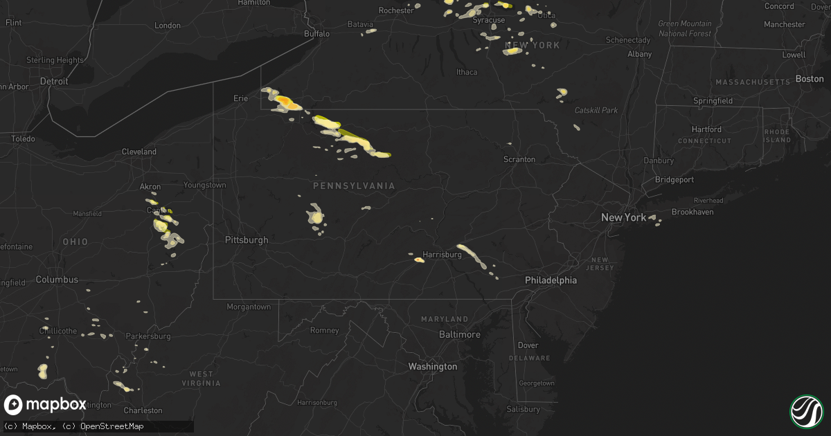
Hail Map in Pennsylvania on September 2, 2013
Get this storm
September 2 map
$229
one time, instant access
Download today. No call, no setup
Keep the $229
Bought the map and want the full workflow? Apply the entire $229 to a subscription within 7 days. None of it is wasted.
Every map, not just this one
This buys you this map. Subscription and you get every map we run, in the markets you choose from a few cities to whole states to nationwide. Plus real-time alerts the moment a storm fires.
Contact data
Name, contact info, occupancy, even credit band for addresses in the footprint. You go from where it hit to who to call.
Become the source they trust
Unlimited branding weather history reports on demand. You already have the documented answer ready for the property owner, and you are the one who showed up with it.
Property data and RoofTrace estimates
Pull up any address you have got, its value and the exact code rules for that jurisdiction, straight from One Click Code. Then RoofTrace estimates the squares, pitch, and roof value, priced the way you price.
Storm reports in Pennsylvania
Pennsylvania
| Date | Description |
|---|---|
| 09/02/20136:57 PM CDT | A local report indicates 1.00 inch wind near 1 N NEW HOLLAND |
| 09/02/20135:50 PM CDT | One tree down in green township on route 580 |
| 09/02/20135:39 PM CDT | Trees reported down in north londonderry twp. |
| 09/02/20134:43 PM CDT | Golf-ball sized hail reported near carlisle. |
| 09/02/20134:26 PM CDT | Small limbs down on route 536 |
| 09/02/20132:45 PM CDT | A local report indicates 1.75 inch wind near 2 WNW AUSTIN |
| 09/02/20132:30 PM CDT | A local report indicates 1.50 inch wind near 4 SE NORWICH |
| 09/02/20131:53 PM CDT | A local report indicates 1.00 inch wind near ORMSBY |
| 09/02/20131:40 PM CDT | A local report indicates 1.00 inch wind near GIFFORD |
| 09/02/20131:33 PM CDT | A local report indicates 1.50 inch wind near LEWIS RUN |
| 09/02/20131:15 PM CDT | Quarter-sized hail reported southwest of bradford. |
| 09/02/201310:56 AM CDT | 4 additional trees reported down according to emergency management |
| 09/02/20139:30 AM CDT | 5 trees down |
All States Impacted by Hail Map on September 2, 2013
Cities Impacted by Hail Map on September 2, 2013
- Cyclone, PA
- Bradford, PA
- Lewis Run, PA
- Carlisle, PA
- Crosby, PA
- Austin, PA
- Dothan, AL
- Smethport, PA
- Emporium, PA
- Jamestown, NY
- Wolcott, NY
- Red Creek, NY
- New Bern, NC
- Palestine, WV
- Oakley, ID
- Dellroy, OH
- Magnolia, OH
- Albany, KY
- Verona, NY
- Westmoreland, NY
- Vernon, NY
- Rome, NY
- Oriskany, NY
- Houston, TX
- South Otselic, NY
- North Pitcher, NY
- De Ruyter, NY
- Smyrna, NY
- Georgetown, NY
- Plymouth, NY
- Pitcher, NY
- Kenna, WV
- Walton, NY
- Downsville, NY
- Hamden, NY
- Walworth, NY
- Marion, NY
- Ontario, NY
- Williamson, NY
- Statesboro, GA
- Daleville, MS
- Meridian, MS
- De Kalb, MS
- Pall Mall, TN
- Savannah, NY
- Ashville, NY
- Lakewood, NY
- Pearson, GA
- Cross Fork, PA
- Renovo, PA
- Otway, OH
- West Portsmouth, OH
- McDermott, OH
- Beaufort, SC
- East Bethany, NY
- Dale, NY
- Wyoming, NY
- Zapata, TX
- Buffalo, WV
- Red House, WV
- Leon, WV
- Clyde, NY
- Overton, NV
- Nanty Glo, PA
- Ebensburg, PA
- Quincy, FL
- Manlius, NY
- Jamesville, NY
- Lebanon, PA
- Drummonds, TN
- Munford, TN
- Millington, TN
- Sterling, NY
- Hannibal, NY
- Oswego, NY
- Belleville, WV
- Rockport, WV
- Hebbronville, TX
- Adrian, GA
- Babylon, NY
- Freeport, OH
- Cadiz, OH
- Kane, PA
- Wilcox, PA
- Mount Jewett, PA
- Hazel Hurst, PA
- Cubero, NM
- Datil, NM
- Bemus Point, NY
- Panama, NY
- Sherman, NY
- Mayville, NY
- Spencer, WV
- Athens, OH
- Nelsonville, OH
- Logan, OH
- Union Furnace, OH
- Le Roy, NY
- Pavilion, NY
- Slocomb, AL
- Annville, PA
- Tarrytown, GA
- Mount Vernon, GA
- Cleveland, NY
- Gifford, PA
- Webster, NY
- Port Byron, NY
- Sherrodsville, OH
- Carrollton, OH
- Bowerston, OH
- Dennison, OH
- Anniston, AL
- Osceola, AR
- Ripley, NY
- Westfield, NY
- Bear Lake, PA
- Sugar Grove, PA
- New Woodstock, NY
- Croghan, NY
- Cobb, GA
- De Soto, GA
- Natural Bridge, NY
- Carthage, NY
- Delhi, NY
- Delancey, NY
- Plattsburgh, NY
- West Chazy, NY
- Massapequa, NY
- Copiague, NY
- Massapequa Park, NY
- Amityville, NY
- Williamsport, TN
- Morris, NY
- Ludowici, GA
- Richmond Hill, GA
- Tennille, GA
- Des Arc, AR
- Charleston, SC
- Covington, TN
- Milton, FL
- Lorida, FL
- Baker, FL
- East Sparta, OH
- Somerdale, OH
- Sandyville, OH
- Dover, OH
- Bolivar, OH
- Mineral City, OH
- Ripley, TN
- Havelock, NC
- Constantia, NY
- Bernhards Bay, NY
- Clymer, PA
- Cherry Tree, PA
- Northern Cambria, PA
- Camden, NY
- Carrolltown, PA
- Saint Benedict, PA
- Fitzgerald, GA
- Enville, TN
- Holt, FL
- Rossiter, PA
- Glen Campbell, PA
- Bamberg, SC
- Millen, GA
- Wrightsville, GA
- Frankfort, OH
- Brockway, PA
- North Canton, OH
- Frankfort, NY
- Ilion, NY
- Southside, WV
- New Plymouth, OH
- Payson, AZ
- Frewsburg, NY
- Russell, PA
- Canton, OH
- Hardeeville, SC
- Bluffton, SC
- Savannah, GA
- Malvern, OH
- Amity, AR
- Rochelle, GA
- Darden, TN
- Scotts Hill, TN
- Chazy, NY
- Newville, PA
- Register, GA
- Fulton, NY
- East Dublin, GA
- Canal Fulton, OH
- Clinton, OH
- Akron, OH
- Massillon, OH
- Lexington, TN
- Le Roy, WV
- Fabius, NY
- Tully, NY
- Apulia Station, NY
- La Fayette, NY
- Colver, PA
- Pensacola, FL
- Warren, PA
- Youngsville, PA
- Irvine, PA
- Cazenovia, NY
- Rhine, GA
- Mims, FL
- Fountain, FL
- Gouverneur, NY
- Pennellville, NY
- Brewerton, NY
- Clay, NY
- De Peyster, NY
- Cottonwood, AL
- Booneville, KY
- Ricetown, KY
- East Canton, OH
- Waynesburg, OH
- Minerva, OH
- Sylvester, GA
- Albany, GA
- Abbeville, GA
- Phoenix, NY
- Portal, GA
- Scio, OH
- Hilton Head Island, SC
- Marion Center, PA
- Hillsdale, PA
- Commodore, PA
- Naples, FL
- Hamilton, NY
- Baldwinsville, NY
- Cato, NY
- Ephrata, PA
- Leola, PA
- Port Matilda, PA
- Saint Marys, PA
- Palmyra, PA
- Christiana, PA
- Kinzers, PA
- Gap, PA
- Malta, ID
- Oviedo, FL
- McRae Helena, GA
- Garfield, GA
- Elkton, KY
- Waverly, OH
- McAlisterville, PA
- Preble, NY
- Homer, NY
- Tupper Lake, NY
- Saranac Lake, NY
- Memphis, TN
- Sugar Grove, OH
- Rockbridge, OH
- Porterville, MS
- Lauderdale, MS
- Bouckville, NY
- Munnsville, NY
- Eaton, NY
- Morrisville, NY
- Chillicothe, OH
- Utica, NY
- Johnsonburg, PA
- Hubbardsville, NY
- Waterville, NY
- Earlville, NY
- Burkesville, KY
- Reevesville, SC
- Mount Pleasant Mills, PA
- Kingman, AZ
- Boynton Beach, FL
- Nicktown, PA
- Emeigh, PA
- Marsteller, PA
- McArthur, OH
- Hobe Sound, FL
- Reagan, TN
- Ravenswood, WV
- Memphis, NY
- Livingston, AL
- Oneida, NY
- Vernon Center, NY
- Sherrill, NY
- Ridgeville, SC
- Ashford, AL
- Brownstown, PA
- Durhamville, NY
- Mcconnelsville, OH
- Ronks, PA
- Gordonville, PA
- Intercourse, PA
- Paradise, PA
- Driftwood, PA
- Apple Grove, WV
- Liberty, WV
- Fraziers Bottom, WV
- Orlando, FL
- East Meadow, NY
- Bellmore, NY
- Wantagh, NY
- Bethpage, NY
- Uniondale, NY
- Levittown, NY
- Hempstead, NY
- Holland Patent, NY
- Clarksburg, OH
- Hurleyville, NY
- Ferndale, NY
- Liberty, NY
- Livingston Manor, NY
- Fort Stewart, GA
- Letart, WV
- Manheim, PA
- Wellton, AZ
- Yuma, AZ
- Hazlehurst, GA
- Denton, GA
- Riceboro, GA
- Harleyville, SC
- Marietta, NY
- Wing, AL
- Cope, SC
- Pembroke, GA
- Stow, NY
- Vero Beach, FL
- Henderson, TN
- Jacks Creek, TN
- Branchville, SC
- Smoaks, SC
- Fort Pierce, FL
- Jordan, NY
- Weedsport, NY
- Syracuse, NY
- Warners, NY
- Liverpool, NY
- Hilliard, FL
- Rutherford, TN
- Kenton, TN
- Lee Center, NY
- Mineral Wells, WV
- Black, AL
- Hartford, AL
- Clarksdale, MS
- Lorraine, NY
- Copenhagen, NY
- Norwich, NY
- South New Berlin, NY
- Jupiter, FL
- Alice, TX
- Marcy, NY
- Whitesboro, NY
- Winnsboro, LA
- Sherburne, NY
- Penn Run, PA
- Westover, PA
- Alverda, PA
- Arcadia, PA
- Rochester Mills, PA
- Starford, PA
- Taberg, NY
- Cantonment, FL
- Robertsdale, AL
- Martville, NY
- Realitos, TX
- Soperton, GA
- Erieville, NY
- Dorchester, SC
- Burlison, TN
- Brighton, TN
- Vanceboro, NC
- Townsend, GA
- York, AL
- Waycross, GA
- Zoar, OH
- Blue Creek, OH
- Peebles, OH
- Champlain, NY
- Pearland, TX
- Piedmont, OH
- Ruffin, SC
- Tunkhannock, PA
- Nicholson, PA
- Factoryville, PA
- Albany, OH
- New Marshfield, OH
- Bowman, SC
- Uniontown, OH
- Jacksonville, GA
- Milan, GA
- Morton, MS
- New Holland, PA
- East Earl, PA
- Locke, NY
- Moravia, NY
- De Queen, AR
- Point Pleasant, WV
- Glenwood, GA
- Puryear, TN
- Lisman, AL
- Dickson, TN
- Lake Placid, FL
- Grantville, PA
- Lititz, PA
- Akron, PA
- Bird In Hand, PA
- Tippecanoe, OH
- Leesville, OH
- New Philadelphia, OH
- Uhrichsville, OH
- Amsterdam, OH
- Jewett, OH
- Punxsutawney, PA
- Coal Run, OH
- Lowell, OH
- Beverly, OH
- Waterford, OH
- Dublin, GA
- Geneva, AL
- Mount Alto, WV
- Cottageville, WV
- Lodge, SC
- Louisville, OH
- Washington, WV
- Tallahassee, FL
- Lucasville, OH
- Piketon, OH
- Celoron, NY
- Columbus, PA
- Corry, PA
- Tibbie, AL
- Pleasantville, OH
- Paris, OH
- North Bend, PA
- Port Allegany, PA
- Islandton, SC
- Walterboro, SC
- Mount Pleasant, SC


