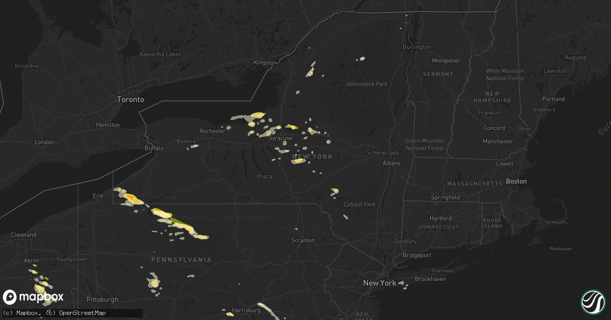
Hail Map in New York on September 2, 2013
Get this storm
September 2 map
$229
one time, instant access
Download today. No call, no setup
Keep the $229
Bought the map and want the full workflow? Apply the entire $229 to a subscription within 7 days. None of it is wasted.
Every map, not just this one
This buys you this map. Subscription and you get every map we run, in the markets you choose from a few cities to whole states to nationwide. Plus real-time alerts the moment a storm fires.
Contact data
Name, contact info, occupancy, even credit band for addresses in the footprint. You go from where it hit to who to call.
Become the source they trust
Unlimited branding weather history reports on demand. You already have the documented answer ready for the property owner, and you are the one who showed up with it.
Property data and RoofTrace estimates
Pull up any address you have got, its value and the exact code rules for that jurisdiction, straight from One Click Code. Then RoofTrace estimates the squares, pitch, and roof value, priced the way you price.
Storm reports in New York
New York
| Date | Description |
|---|---|
| 09/02/20136:04 PM CDT | Trees down across town of butternuts. |
| 09/02/20135:55 PM CDT | Wires down and arcing on rasch road. |
| 09/02/20135:52 PM CDT | Trees down on wires on taft street. |
| 09/02/20135:41 PM CDT | Trees down on main street and dockey street. |
| 09/02/20135:36 PM CDT | Trees and wires down on the utica schuyler border |
| 09/02/20135:25 PM CDT | Silo down on a barn. Time estimated by radar. |
| 09/02/20135:15 PM CDT | Tree down and many limbs. Wires down on 540 litchfield street. |
| 09/02/20135:14 PM CDT | Trees down throughout town of plainfied. |
| 09/02/20135:13 PM CDT | A local report indicates 1.00 inch wind near FAIRFIELD |
| 09/02/20135:05 PM CDT | A local report indicates 1.00 inch wind near OTSELIC |
| 09/02/20135:00 PM CDT | Picture posted to our wall. |
| 09/02/20135:00 PM CDT | Multiple trees snapped at the base. Picture via the utica od website. Seymour park |
| 09/02/20134:53 PM CDT | Numerous trees down in north utica |
| 09/02/20134:45 PM CDT | Trees and wires down. |
| 09/02/20134:45 PM CDT | Tree down on moose river rd. |
| 09/02/20134:40 PM CDT | Tree down on houseville rd. |
| 09/02/20134:40 PM CDT | Trees and wires down on lake house rd. |
| 09/02/20134:35 PM CDT | Pole and wires down. |
| 09/02/20134:30 PM CDT | *** 1 inj *** tree fell on car with one injury due to windshield glass shattering |
| 09/02/20134:21 PM CDT | Also...estimated 50 mph wind associated with storm |
| 09/02/20134:21 PM CDT | Trees down at both vernon and delta dam in oneida county. |
| 09/02/20134:20 PM CDT | Trees down. |
| 09/02/20134:15 PM CDT | Numerous branches down some 3 to 4 inch in diameter. |
| 09/02/20134:15 PM CDT | Wind was estimated at 55 to 60 mph along with dime sized hail |
| 09/02/20134:10 PM CDT | A local report indicates 1.00 inch wind near NEW LONDON |
| 09/02/20134:08 PM CDT | Wires down. |
| 09/02/20134:03 PM CDT | Picture posted to jill reales facebook page via wktv-tv. Estimated by picture to be at least 2 inches in diameter. |
| 09/02/20133:52 PM CDT | Hail ongoing at time of call |
| 09/02/20133:49 PM CDT | Trees down |
| 09/02/20133:39 PM CDT | Trees down on paridise rd. |
| 09/02/20133:36 PM CDT | Trees down on jordan rd. |
| 09/02/20133:35 PM CDT | A local report indicates 1.00 inch wind near NW MARION |
| 09/02/20133:35 PM CDT | Trees down. |
| 09/02/20133:21 PM CDT | A local report indicates 60 MPH wind near OSWEGO |
| 09/02/20133:18 PM CDT | A local report indicates 1.00 inch wind near OSWEGO |
| 09/02/20133:17 PM CDT | Trees down on short cut rd and craine rd. |
| 09/02/20133:16 PM CDT | Trees down on rathburn rd. |
| 09/02/20133:15 PM CDT | Dime to quarter sized hail reported |
| 09/02/20133:15 PM CDT | Wires down. |
| 09/02/20133:12 PM CDT | A local report indicates 1.25 inch wind near RED CREEK |
| 09/02/20133:11 PM CDT | A local report indicates 1.25 inch wind near SOUTHWEST OSWEGO |
| 09/02/20133:05 PM CDT | A local report indicates 1.00 inch wind near NORTH WOLCOTT |
| 09/02/20133:00 PM CDT | A local report indicates 1.25 inch wind near 1 SSW RED CREEK |
| 09/02/20132:03 PM CDT | Relayed by wfo buffalo |
| 09/02/20132:00 PM CDT | Facebook report of penny and quarter sized hail off jordan rd near cross lake. |
| 09/02/201312:07 PM CDT | From wjtn |
| 09/02/201312:03 PM CDT | Trees down...from wjtn |
| 09/02/201312:00 PM CDT | From wivb. |
| 09/02/201312:00 PM CDT | Sailboats in lake and on shore flipped... Trees and power lines down at chautauqua lake yacht club |
| 09/02/201312:00 PM CDT | One diameter hail covered the green at sunset valley golf course |
| 09/02/201311:57 AM CDT | Time estimated based on radar |
| 09/02/201311:57 AM CDT | From wivb at ashville. |
| 09/02/201311:50 AM CDT | Trees down near chautauqua lake...time estimated...from wjtn |
| 09/02/201311:25 AM CDT | Estimated quarter sized hail at the chautauqua institution |
| 09/02/20136:30 AM CDT | 3-4 trees down across amityville. |
| 09/02/20136:25 AM CDT | Quarter size hail reported near burner middle school on carman mill road. |
All States Impacted by Hail Map on September 2, 2013
Cities Impacted by Hail Map on September 2, 2013
- Cyclone, PA
- Bradford, PA
- Lewis Run, PA
- Carlisle, PA
- Crosby, PA
- Austin, PA
- Dothan, AL
- Smethport, PA
- Emporium, PA
- Jamestown, NY
- Wolcott, NY
- Red Creek, NY
- New Bern, NC
- Palestine, WV
- Oakley, ID
- Dellroy, OH
- Magnolia, OH
- Albany, KY
- Verona, NY
- Westmoreland, NY
- Vernon, NY
- Rome, NY
- Oriskany, NY
- Houston, TX
- South Otselic, NY
- North Pitcher, NY
- De Ruyter, NY
- Smyrna, NY
- Georgetown, NY
- Plymouth, NY
- Pitcher, NY
- Kenna, WV
- Walton, NY
- Downsville, NY
- Hamden, NY
- Walworth, NY
- Marion, NY
- Ontario, NY
- Williamson, NY
- Statesboro, GA
- Daleville, MS
- Meridian, MS
- De Kalb, MS
- Pall Mall, TN
- Savannah, NY
- Ashville, NY
- Lakewood, NY
- Pearson, GA
- Cross Fork, PA
- Renovo, PA
- Otway, OH
- West Portsmouth, OH
- McDermott, OH
- Beaufort, SC
- East Bethany, NY
- Dale, NY
- Wyoming, NY
- Zapata, TX
- Buffalo, WV
- Red House, WV
- Leon, WV
- Clyde, NY
- Overton, NV
- Nanty Glo, PA
- Ebensburg, PA
- Quincy, FL
- Manlius, NY
- Jamesville, NY
- Lebanon, PA
- Drummonds, TN
- Munford, TN
- Millington, TN
- Sterling, NY
- Hannibal, NY
- Oswego, NY
- Belleville, WV
- Rockport, WV
- Hebbronville, TX
- Adrian, GA
- Babylon, NY
- Freeport, OH
- Cadiz, OH
- Kane, PA
- Wilcox, PA
- Mount Jewett, PA
- Hazel Hurst, PA
- Cubero, NM
- Datil, NM
- Bemus Point, NY
- Panama, NY
- Sherman, NY
- Mayville, NY
- Spencer, WV
- Athens, OH
- Nelsonville, OH
- Logan, OH
- Union Furnace, OH
- Le Roy, NY
- Pavilion, NY
- Slocomb, AL
- Annville, PA
- Tarrytown, GA
- Mount Vernon, GA
- Cleveland, NY
- Gifford, PA
- Webster, NY
- Port Byron, NY
- Sherrodsville, OH
- Carrollton, OH
- Bowerston, OH
- Dennison, OH
- Anniston, AL
- Osceola, AR
- Ripley, NY
- Westfield, NY
- Bear Lake, PA
- Sugar Grove, PA
- New Woodstock, NY
- Croghan, NY
- Cobb, GA
- De Soto, GA
- Natural Bridge, NY
- Carthage, NY
- Delhi, NY
- Delancey, NY
- Plattsburgh, NY
- West Chazy, NY
- Massapequa, NY
- Copiague, NY
- Massapequa Park, NY
- Amityville, NY
- Williamsport, TN
- Morris, NY
- Ludowici, GA
- Richmond Hill, GA
- Tennille, GA
- Des Arc, AR
- Charleston, SC
- Covington, TN
- Milton, FL
- Lorida, FL
- Baker, FL
- East Sparta, OH
- Somerdale, OH
- Sandyville, OH
- Dover, OH
- Bolivar, OH
- Mineral City, OH
- Ripley, TN
- Havelock, NC
- Constantia, NY
- Bernhards Bay, NY
- Clymer, PA
- Cherry Tree, PA
- Northern Cambria, PA
- Camden, NY
- Carrolltown, PA
- Saint Benedict, PA
- Fitzgerald, GA
- Enville, TN
- Holt, FL
- Rossiter, PA
- Glen Campbell, PA
- Bamberg, SC
- Millen, GA
- Wrightsville, GA
- Frankfort, OH
- Brockway, PA
- North Canton, OH
- Frankfort, NY
- Ilion, NY
- Southside, WV
- New Plymouth, OH
- Payson, AZ
- Frewsburg, NY
- Russell, PA
- Canton, OH
- Hardeeville, SC
- Bluffton, SC
- Savannah, GA
- Malvern, OH
- Amity, AR
- Rochelle, GA
- Darden, TN
- Scotts Hill, TN
- Chazy, NY
- Newville, PA
- Register, GA
- Fulton, NY
- East Dublin, GA
- Canal Fulton, OH
- Clinton, OH
- Akron, OH
- Massillon, OH
- Lexington, TN
- Le Roy, WV
- Fabius, NY
- Tully, NY
- Apulia Station, NY
- La Fayette, NY
- Colver, PA
- Pensacola, FL
- Warren, PA
- Youngsville, PA
- Irvine, PA
- Cazenovia, NY
- Rhine, GA
- Mims, FL
- Fountain, FL
- Gouverneur, NY
- Pennellville, NY
- Brewerton, NY
- Clay, NY
- De Peyster, NY
- Cottonwood, AL
- Booneville, KY
- Ricetown, KY
- East Canton, OH
- Waynesburg, OH
- Minerva, OH
- Sylvester, GA
- Albany, GA
- Abbeville, GA
- Phoenix, NY
- Portal, GA
- Scio, OH
- Hilton Head Island, SC
- Marion Center, PA
- Hillsdale, PA
- Commodore, PA
- Naples, FL
- Hamilton, NY
- Baldwinsville, NY
- Cato, NY
- Ephrata, PA
- Leola, PA
- Port Matilda, PA
- Saint Marys, PA
- Palmyra, PA
- Christiana, PA
- Kinzers, PA
- Gap, PA
- Malta, ID
- Oviedo, FL
- McRae Helena, GA
- Garfield, GA
- Elkton, KY
- Waverly, OH
- McAlisterville, PA
- Preble, NY
- Homer, NY
- Tupper Lake, NY
- Saranac Lake, NY
- Memphis, TN
- Sugar Grove, OH
- Rockbridge, OH
- Porterville, MS
- Lauderdale, MS
- Bouckville, NY
- Munnsville, NY
- Eaton, NY
- Morrisville, NY
- Chillicothe, OH
- Utica, NY
- Johnsonburg, PA
- Hubbardsville, NY
- Waterville, NY
- Earlville, NY
- Burkesville, KY
- Reevesville, SC
- Mount Pleasant Mills, PA
- Kingman, AZ
- Boynton Beach, FL
- Nicktown, PA
- Emeigh, PA
- Marsteller, PA
- McArthur, OH
- Hobe Sound, FL
- Reagan, TN
- Ravenswood, WV
- Memphis, NY
- Livingston, AL
- Oneida, NY
- Vernon Center, NY
- Sherrill, NY
- Ridgeville, SC
- Ashford, AL
- Brownstown, PA
- Durhamville, NY
- Mcconnelsville, OH
- Ronks, PA
- Gordonville, PA
- Intercourse, PA
- Paradise, PA
- Driftwood, PA
- Apple Grove, WV
- Liberty, WV
- Fraziers Bottom, WV
- Orlando, FL
- East Meadow, NY
- Bellmore, NY
- Wantagh, NY
- Bethpage, NY
- Uniondale, NY
- Levittown, NY
- Hempstead, NY
- Holland Patent, NY
- Clarksburg, OH
- Hurleyville, NY
- Ferndale, NY
- Liberty, NY
- Livingston Manor, NY
- Fort Stewart, GA
- Letart, WV
- Manheim, PA
- Wellton, AZ
- Yuma, AZ
- Hazlehurst, GA
- Denton, GA
- Riceboro, GA
- Harleyville, SC
- Marietta, NY
- Wing, AL
- Cope, SC
- Pembroke, GA
- Stow, NY
- Vero Beach, FL
- Henderson, TN
- Jacks Creek, TN
- Branchville, SC
- Smoaks, SC
- Fort Pierce, FL
- Jordan, NY
- Weedsport, NY
- Syracuse, NY
- Warners, NY
- Liverpool, NY
- Hilliard, FL
- Rutherford, TN
- Kenton, TN
- Lee Center, NY
- Mineral Wells, WV
- Black, AL
- Hartford, AL
- Clarksdale, MS
- Lorraine, NY
- Copenhagen, NY
- Norwich, NY
- South New Berlin, NY
- Jupiter, FL
- Alice, TX
- Marcy, NY
- Whitesboro, NY
- Winnsboro, LA
- Sherburne, NY
- Penn Run, PA
- Westover, PA
- Alverda, PA
- Arcadia, PA
- Rochester Mills, PA
- Starford, PA
- Taberg, NY
- Cantonment, FL
- Robertsdale, AL
- Martville, NY
- Realitos, TX
- Soperton, GA
- Erieville, NY
- Dorchester, SC
- Burlison, TN
- Brighton, TN
- Vanceboro, NC
- Townsend, GA
- York, AL
- Waycross, GA
- Zoar, OH
- Blue Creek, OH
- Peebles, OH
- Champlain, NY
- Pearland, TX
- Piedmont, OH
- Ruffin, SC
- Tunkhannock, PA
- Nicholson, PA
- Factoryville, PA
- Albany, OH
- New Marshfield, OH
- Bowman, SC
- Uniontown, OH
- Jacksonville, GA
- Milan, GA
- Morton, MS
- New Holland, PA
- East Earl, PA
- Locke, NY
- Moravia, NY
- De Queen, AR
- Point Pleasant, WV
- Glenwood, GA
- Puryear, TN
- Lisman, AL
- Dickson, TN
- Lake Placid, FL
- Grantville, PA
- Lititz, PA
- Akron, PA
- Bird In Hand, PA
- Tippecanoe, OH
- Leesville, OH
- New Philadelphia, OH
- Uhrichsville, OH
- Amsterdam, OH
- Jewett, OH
- Punxsutawney, PA
- Coal Run, OH
- Lowell, OH
- Beverly, OH
- Waterford, OH
- Dublin, GA
- Geneva, AL
- Mount Alto, WV
- Cottageville, WV
- Lodge, SC
- Louisville, OH
- Washington, WV
- Tallahassee, FL
- Lucasville, OH
- Piketon, OH
- Celoron, NY
- Columbus, PA
- Corry, PA
- Tibbie, AL
- Pleasantville, OH
- Paris, OH
- North Bend, PA
- Port Allegany, PA
- Islandton, SC
- Walterboro, SC
- Mount Pleasant, SC


