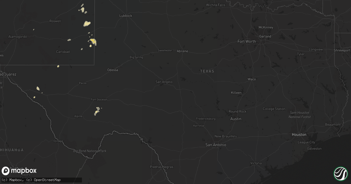
Hail Map in Texas on September 1, 2018
Get this storm
September 1 map
$229
one time, instant access
Download today. No call, no setup
Keep the $229
Bought the map and want the full workflow? Apply the entire $229 to a subscription within 7 days. None of it is wasted.
Every map, not just this one
This buys you this map. Subscription and you get every map we run, in the markets you choose from a few cities to whole states to nationwide. Plus real-time alerts the moment a storm fires.
Contact data
Name, contact info, occupancy, even credit band for addresses in the footprint. You go from where it hit to who to call.
Become the source they trust
Unlimited branding weather history reports on demand. You already have the documented answer ready for the property owner, and you are the one who showed up with it.
Property data and RoofTrace estimates
Pull up any address you have got, its value and the exact code rules for that jurisdiction, straight from One Click Code. Then RoofTrace estimates the squares, pitch, and roof value, priced the way you price.
Storm reports in Texas
Texas
| Date | Description |
|---|---|
| 09/01/20186:14 PM CDT | Golf ball sized hail reported near rhs |
| 09/01/20186:14 PM CDT | Power poles and tree limbs broken. |
| 09/01/20186:05 PM CDT | Schoolnet |
| 09/01/20185:56 PM CDT | Schoolnet |
| 09/01/20181:11 AM CDT | At 609 PM CDT, a severe thunderstorm was located near Amarillo, moving north at 25 mph. HAZARD...Ping pong ball size hail and 60 mph wind gusts. This storm is in the Canyon area moving north about 25 mph towards western Amarillo. A line of storms west of Amarillo is expected to bring wind gusts to 60 mph to the metro area soon. SOURCE...Trained weather spotters. IMPACT...Minor damage to roofs, siding, and trees is possible. People and animals outdoors will be injured. Expect hail damage to roofs, siding, windows, and vehicles. Locations impacted include... Amarillo, Canyon, Lake Tanglewood, Mescalero Park, Buffalo Lake, Bushland, Valley De Oro, Umbarger, Palo Duro Canyon and Timbercreek Canyon. |
| 09/01/201812:28 AM CDT | At 528 PM MDT, a severe thunderstorm was located 13 miles northeast of Sierra Blanca, moving north at 10 mph. HAZARD...60 mph wind gusts and quarter size hail. SOURCE...Radar indicated. IMPACT...Hail damage to vehicles is expected. Expect wind damage to roofs, siding, and trees. Locations impacted include... Sunset Ranches. |
| 08/31/201811:40 PM CDT | At 440 PM MDT, a severe thunderstorm was located near Allamoore, moving east at 10 mph. HAZARD...60 mph wind gusts and quarter size hail. SOURCE...Radar indicated. IMPACT...Hail damage to vehicles is expected. Expect wind damage to roofs, siding, and trees. Locations impacted include... Allamoore. |
| 08/31/201810:47 PM CDT | At 347 PM MDT, a severe thunderstorm was located 8 miles west of Frenchman Canyon, or 9 miles north of Indian Hot Springs, moving northeast at 10 mph. HAZARD...60 mph wind gusts and quarter size hail. SOURCE...Radar indicated. IMPACT...Hail damage to vehicles is expected. Expect wind damage to roofs, siding, and trees. Locations impacted include... Frenchman Canyon. |
| 08/31/201810:37 PM CDT | At 336 PM CDT/236 PM MDT/, a severe thunderstorm was located 13 miles south of Whites City, or 27 miles east of Pine Springs, moving east at 15 mph. HAZARD...Quarter size hail. SOURCE...Radar indicated. IMPACT...Damage to vehicles is expected. This severe thunderstorm will remain over mainly rural areas of south central Eddy and north central Culberson Counties. |
All States Impacted by Hail Map on September 1, 2018
Cities Impacted by Hail Map on September 1, 2018
- Oakes, ND
- Knoxville, IA
- Monroe, IA
- Pleasantville, IA
- Dandridge, TN
- White Pine, TN
- Dunbar, NE
- Syracuse, NE
- Otoe, NE
- Sidney, NE
- Potter, NE
- Mitchellville, IA
- Colfax, IA
- Prairie City, IA
- Hobbs, NM
- Adel, IA
- Chadron, NE
- Whitney, NE
- Glen Elder, KS
- Tonalea, AZ
- Adams, NE
- Glenwood, IA
- Avoca, NE
- Pacific Junction, IA
- Panama, NE
- Plattsmouth, NE
- Sidney, IA
- Martell, NE
- Percival, IA
- Elmwood, NE
- Eagle, NE
- Tabor, IA
- Douglas, NE
- Roca, NE
- Murray, NE
- Thurman, IA
- Weeping Water, NE
- Bennet, NE
- Nehawka, NE
- Palmyra, NE
- Nebraska City, NE
- Walton, NE
- Malvern, IA
- Lincoln, NE
- Hickman, NE
- Firth, NE
- Unadilla, NE
- Union, NE
- Jetersville, VA
- Amelia Court House, VA
- Albia, IA
- Stockton, KS
- Plainville, KS
- Palco, KS
- Lucas, KS
- Luray, KS
- Trail City, SD
- McLaughlin, SD
- Glencross, SD
- Timber Lake, SD
- Edgerton, MN
- Vernon Hills, IL
- Mundelein, IL
- Lake Zurich, IL
- Clifton, KS
- Haddam, KS
- Holbrook, AZ
- Natoma, KS
- Sierra Blanca, TX
- Flagstaff, AZ
- Winslow, AZ
- Des Moines, IA
- Johnston, IA
- Hedrick, IA
- Dalton, NE
- Dix, NE
- Hays, KS
- Victoria, KS
- McIntosh, SD
- Staples, MN
- Motley, MN
- Fox Lake, IL
- Ingleside, IL
- Mchenry, IL
- Selby, SD
- Java, SD
- Eagle Butte, SD
- Apple River, IL
- Scales Mound, IL
- Show Low, AZ
- Padroni, CO
- Stoneham, CO
- Selfridge, ND
- Fort Yates, ND
- Mankato, KS
- Courtland, KS
- Webber, KS
- Ankeny, IA
- Bondurant, IA
- Berwick, IA
- Altoona, IA
- Urbandale, IA
- Rothsay, MN
- Pelican Rapids, MN
- Erhard, MN
- Elizabeth, MN
- Grosse Ile, MI
- Trenton, MI
- Wyandotte, MI
- Riverview, MI
- Keota, IA
- Harper, IA
- South English, IA
- Gila, NM
- Silver City, NM
- Lebanon, SD
- Gettysburg, SD
- Oskaloosa, IA
- Fremont, IA
- Rose Hill, IA
- Cedar, IA
- Delta, IA
- Madrid, IA
- Belleville, KS
- Cornell, WI
- Holcombe, WI
- Cumming, IA
- West Des Moines, IA
- Tatum, NM
- Dallas Center, IA
- Granger, IA
- Woodward, IA
- New Raymer, CO
- Amarillo, TX
- Marshall, MI
- North English, IA
- Alleman, IA
- Brewster, MN
- Osborne, KS
- Willcox, AZ
- Polo, IL
- Chippewa Falls, WI
- Eddyville, IA
- Ottumwa, IA
- Oregon, IL
- Leaf River, IL
- Gorham, KS
- Russell, KS
- Sylvan Grove, KS
- Bunker Hill, KS
- Walker, KS
- Pfeifer, KS
- Catharine, KS
- Hunter, KS
- Otis, KS
- Paradise, KS
- Ellis, KS
- Waldo, KS
- Lidgerwood, ND
- Wyndmere, ND
- Wakeeney, KS
- Wishek, ND
- Zeeland, ND
- Chana, IL
- Rochelle, IL
- Tallassee, TN
- Formoso, KS
- Brownell, KS
- Mount Pleasant, IA
- Wayland, IA
- Pequot Lakes, MN
- New York Mills, MN
- Sebeka, MN
- Fulton, IL
- Thomson, IL
- Agate, CO
- Gloucester, VA
- Whites Creek, TN
- Nashville, TN
- Concho, AZ
- Snowflake, AZ
- Powhatan, VA
- Crozier, VA
- Bouton, IA
- Minburn, IA
- Perry, IA
- Richland, IA
- Fairfield, IA
- Savanna, IL
- Mount Carroll, IL
- Morrowville, KS
- Burr Oak, KS
- Jamestown, KS
- Hubbell, NE
- Tipton, KS
- Downs, KS
- Cawker City, KS
- Munden, KS
- Beloit, KS
- Narka, KS
- Mahaska, KS
- Agenda, KS
- Esbon, KS
- Cuba, KS
- Republic, KS
- Scandia, KS
- Randall, KS
- Reynolds, NE
- Concordia, KS
- Jewell, KS
- Fairbury, NE
- Norway, KS
- Cary, IL
- Barrington, IL
- Crook, CO
- Iliff, CO
- Cook, NE
- Talmage, NE
- Saint Michaels, AZ
- Pearce, AZ
- Elon, NC
- Gibsonville, NC
- Forreston, IL
- Freeport, IL
- Baileyville, IL
- Lanark, IL
- Shannon, IL
- Cumberland, IA
- Artesia, NM
- Leonard, ND
- Kimball, NE
- Cornville, AZ
- Weldona, CO
- Snow Camp, NC
- Burlington, NC
- Liberty, NC
- Leupp, AZ
- Tuba City, AZ
- Davenport, ND
- Morganton, NC
- La Crosse, KS
- Waukee, IA
- Elizabeth, IL
- Hanover, IL
- Ottertail, MN
- Rockford, IL
- Winnebago, IL
- Gilman, IA
- Blaine, KY
- Ganado, AZ
- Navajo, NM
- Oxford, NC
- Sigourney, IA
- Ollie, IA
- What Cheer, IA
- Crete, NE
- Fort Stockton, TX
- Charleston, TN
- Georgetown, TN
- Marion, ND
- Pine River, MN
- Backus, MN
- Strasburg, ND
- Animas, NM
- Parkers Prairie, MN
- Farmville, NC
- Greenville, NC
- Cliff, NM
- Buckhorn, NM
- Nisswa, MN
- Earlham, IA
- Stirum, ND
- Mount Morris, IL
- Fontanelle, IA
- Julian, NE
- Peru, NE
- Brock, NE
- Cambridge, IA
- Manakin Sabot, VA
- Albany, IL
- Runnells, IA
- Woodston, KS
- Gurley, NE
- Menahga, MN
- Wadena, MN
- Kellogg, IA
- Reasnor, IA
- Newton, IA
- Ogallah, KS
- Hill City, KS
- Dodge City, KS
- Seminole, TX
- Union City, MI
- Sherwood, MI
- Utica, KS
- Collyer, KS
- Concord, NC
- Whiteriver, AZ
- Corning, IA
- Ransom, KS
- Elida, NM
- San Simon, AZ
- Hahira, GA
- Frederick, SD
- Maryville, TN
- Beardsley, MN
- Bronson, MI
- Cortez, CO
- Edgeley, ND
- Dickey, ND
- Sheldon, WI
- Gilman, WI
- Elfrida, AZ
- Marquette, MI
- Muscatine, IA
- Illinois City, IL
- Enderlin, ND
- Fingal, ND
- Nome, ND
- Cochrane, WI
- Auburn, NE
- Sterling, IL
- Dixon, IL
- Montgomery, MI
- Fremont, IN
- Coldwater, MI
- Lawrenceville, VA
- Searsboro, IA
- Montezuma, IA
- New Sharon, IA
- Chicago, IL
- Harwood Heights, IL
- Denton, NC
- Lexington, NC
- Pillager, MN
- Browerville, MN
- Brainerd, MN
- Baxter, MN
- Verndale, MN
- Quemado, NM
- Suffolk, VA
- Lake In The Hills, IL
- Algonquin, IL
- Hoffman Estates, IL
- Schaumburg, IL
- Grinnell, IA
- Genoa, WV
- Grimes, IA
- Polk City, IA
- Hewitt, MN
- Henning, MN
- Litchville, ND
- Kathryn, ND
- Fort Ransom, ND
- Horace, ND
- Darlington, WI
- Merrifield, MN
- Huntley, IL
- Hampshire, IL
- Marengo, IL
- Dundee, IL
- Union, IL
- Benson, AZ
- East Lynn, WV
- Wayne, WV
- Hanna City, IL
- Trivoli, IL
- Bethel, NC
- Oak Brook, IL
- Berkeley, IL
- Melrose Park, IL
- Elmhurst, IL
- Bellwood, IL
- Stone Park, IL
- Hillside, IL
- Villa Park, IL
- Highmore, SD
- Sheldon, ND
- Ogden, IA
- Branchland, WV
- Lamoure, ND
- Berlin, ND
- Maxwell, IA
- Huxley, IA
- Windsor Heights, IA
- De Soto, IA
- Slater, IA
- Clive, IA
- Ames, IA
- Van Meter, IA
- Kelley, IA
- Norwalk, IA
- Pleasant Hill, IA
- Elkhart, IA
- Cochise, AZ
- Tombstone, AZ
- Morrison, IL
- Thatcher, AZ
- Franklinton, NC
- Pep, NM
- Viola, IL
- Happy Jack, AZ
- Mcleod, ND
- Fenton, IL
- Erie, IL
- Williamsburg, NM
- Truth Or Consequences, NM
- Sutherland, IA
- Paullina, IA
- Cleghorn, IA
- Meriden, IA
- Odebolt, IA
- Creedmoor, NC
- Stem, NC
- Albion, MI
- Goldsboro, NC
- Tekonsha, MI
- Athens, MI
- Burlington, MI
- Marlette, MI
- Kingston, MI
- Woosung, IL
- Osceola, IA
- New Virginia, IA
- Deer Trail, CO
- Arenas Valley, NM
- Deer Creek, MN
- Arlington Heights, IL
- Palatine, IL
- Rolling Meadows, IL
- Durham, NC
- Wake Forest, NC
- Raleigh, NC
- Watauga, SD
- Milledgeville, IL
- Randolph, IA
- Kykotsmovi Village, AZ
- Lovington, NM
- Allegan, MI
- Kalamazoo, MI
- Gobles, MI
- Otsego, MI
- Chappell, NE
- Clyde, KS
- Central City, IA
- Anamosa, IA
- Douglas, AZ
- Lyndon, IL
- Merry Hill, NC
- Colerain, NC
- Wolverton, MN
- Sterling, NE
- Onida, SD
- Scottsville, VA
- Brighton, IA
- Wauconda, IL
- Montour, IA
- Bowdle, SD
- Hanover Park, IL
- Clatonia, NE
- Pickrell, NE
- De Witt, NE
- Cortland, NE
- Salt Flat, TX
- Angola, IN
- Greenbrier, TN
- Goodlettsville, TN
- Bridgeport, NE
- Beatrice, NE
- Villisca, IA
- Lisbon, ND
- Onslow, IA
- West Fargo, ND
- Park, KS
- Hoxie, KS
- Quinter, KS
- Tohatchi, NM
- Deming, NM
- Perham, MN
- Kindred, ND
- Lindenwood, IL
- Mayhill, NM
- Farmington, IL
- Libertyville, IL
- Grayslake, IL
- Kingston, IL
- Kirkland, IL
- Belvidere, IL
- Leonidas, MI
- Colon, MI
- Aldrich, MN
- Wakefield, VA
- Dearborn, MI
- Detroit, MI
- Melvindale, MI
- Concord, MI
- Chadwick, IL
- Halifax, NC
- Sisseton, SD
- Prescott, IA
- Wilber, NE
- Linn, KS
- Mooreton, ND
- Hankinson, ND
- Milnesand, NM
- Wausau, WI
- Steinhatchee, FL
- Pleasant Hill, NC
- Deep River, IA
- Isabel, SD
- Polo, MO
- Primghar, IA
- Collins, IA
- Colo, IA
- Elberon, VA
- Galena, IL
- Packwood, IA
- Webster, IA
- Cape Coral, FL
- Hague, ND
- Peetz, CO
- Barnes City, IA
- Imogene, IA
- Emerson, IA
- Hastings, IA
- Clifton, AZ
- Box Elder, SD
- Underwood, MN
- Fergus Falls, MN
- Hayesville, IA
- Martinsburg, IA
- South Hill, VA
- Wyoming, IA
- Monmouth, IA
- Monroe Center, IL
- Davis Junction, IL
- Woodstock, IL
- Virginia Beach, VA
- Mapleton, ND
- Otley, IA
- Crawford, NE
- Shullsburg, WI
- Glenham, SD
- Mound City, SD
- McCracken, KS
- East Leroy, MI
- Fulton, MI
- Winterset, IA
- San Carlos, AZ
- Elk Mound, WI
- Menomonie, WI
- Dent, MN
- Colfax, WI
- Zwingle, IA
- Elk Grove Village, IL
- Roselle, IL
- Merino, CO
- Richville, MN
- Cogswell, ND
- Rapid City, SD
- Bagley, IA
- Bellevue, IA
- Henderson, NC
- Mingo, IA
- Plymouth, NE
- Jansen, NE
- Pecatonica, IL
- Hallam, NE
- Friend, NE
- Des Plaines, IL
- Elbow Lake, MN
- Alexis, IL
- Aledo, IL
- Rippey, IA
- Lawson, MO
- Westport, SD
- Prophetstown, IL
- Rock Falls, IL
- Letts, IA
- Glasford, IL
- Canton, IL
- Elmwood, IL
- Brimfield, IL
- Yates City, IL
- Mancos, CO
- Garysburg, NC
- Skippers, VA
- Woodstock, MN
- Evanston, IL
- Swanton, NE
- Indian Rocks Beach, FL
- Jud, ND
- Liberal, KS
- Gastonia, NC
- Menlo, IA
- Sedona, AZ


