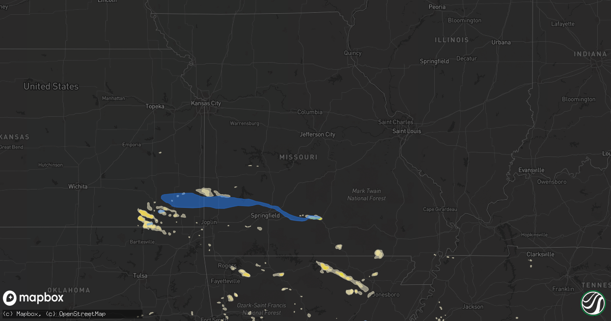
Hail Map in Missouri on August 29, 2020
Get this storm
August 29 map
$229
one time, instant access
Download today. No call, no setup
Keep the $229
Bought the map and want the full workflow? Apply the entire $229 to a subscription within 7 days. None of it is wasted.
Every map, not just this one
This buys you this map. Subscription and you get every map we run, in the markets you choose from a few cities to whole states to nationwide. Plus real-time alerts the moment a storm fires.
Contact data
Name, contact info, occupancy, even credit band for addresses in the footprint. You go from where it hit to who to call.
Become the source they trust
Unlimited branding weather history reports on demand. You already have the documented answer ready for the property owner, and you are the one who showed up with it.
Property data and RoofTrace estimates
Pull up any address you have got, its value and the exact code rules for that jurisdiction, straight from One Click Code. Then RoofTrace estimates the squares, pitch, and roof value, priced the way you price.
Storm reports in Missouri
Missouri
| Date | Description |
|---|---|
| 08/29/202012:33 PM CDT | Picture on social media relayed via media partner of a storage trailer blown onto its side as well as some shingles torn off in cabool. Time estimated from radar. |
| 08/29/202012:18 PM CDT | Preliminary damage reported across mountain grove south of hwy 60. A grocery store awning damaged. A carwash room collapsed on a vehicle. Several trees down. Minor or n |
| 08/29/202011:40 AM CDT | Picture of a large tree limb that fell onto a parked car in ava... Mo. Time estimated from radar. |
| 08/29/202011:26 AM CDT | Report via social media. Multiple large tree limbs blown down. Also structural damage ranging from garage doors to outbuildings being blown over. Time estimated from ra |
| 08/29/202011:25 AM CDT | Large limbs blocking most of road at james river bridge on hwy b south of northview. |
| 08/29/202011:22 AM CDT | Several tree limbs downed 4 to 8 inches in diameter. |
| 08/29/202010:54 AM CDT | Sgf airport. 51kts at 1554 utc. |
| 08/29/202010:54 AM CDT | Large maple tree snapped low on the trunk on north bristol ave. In northeastern springfield... Mo. Time estimated from radar. |
| 08/29/202010:35 AM CDT | Couple of 6 inch diameter tree limbs downed near downtown walnut grove. |
| 08/29/202010:27 AM CDT | Corrects previous tstm wnd gst report from 5 sse willard. Sgf asos. |
| 08/29/202010:24 AM CDT | Sgf asos. |
| 08/29/202010:20 AM CDT | Walnut grove fire estimates 60 mph gusts. |
| 08/29/202010:19 AM CDT | Tree down on e 7th st in cassville. Another tree down blocking farm road 2180 and farm road 1140. |
| 08/29/20209:46 AM CDT | Report of power lines down in miller. |
| 08/29/20209:30 AM CDT | Numerous trees... Limbs and power lines down throughout the city of lamar. Damage to booths and equipment in downtown lamar at the fair. |
| 08/29/20209:27 AM CDT | Home weather station reported 59.2 mph gust. |
| 08/29/20209:24 AM CDT | Delayed report. Freightliner semi trailer pushed over by gusty thunderstorm winds on i49 near lamar exit. |
| 08/29/20209:15 AM CDT | Utility pole down in the city of jasper. |
| 08/29/20209:10 AM CDT | Tree downed. |
| 08/29/20209:04 AM CDT | Tree downed. |
| 08/29/20207:14 AM CDT | At 1213 PM CDT, severe thunderstorms were located along a line extending from 10 miles northeast of Hartville to 7 miles north of Norwood to near Mountain Grove to 7 miles west of Cabool, moving east at 40 mph. HAZARD...60 mph wind gusts. SOURCE...Radar indicated. This line of storms has a history of downing tree and tree limbs a long with power lines. IMPACT...Expect damage to roofs, siding, and trees. Locations impacted include... Mountain Grove... Mountain View... Willow Springs... Cabool... Houston... Summersville... Raymondville... Huggins... Arroll... Bucyrus... Elk Creek... Eunice... Yukon... Hartshorn... Clear Springs... Solo... Pine Crest... Simmons... Bendavis... |
| 08/29/20206:34 AM CDT | At 1133 AM CDT, severe thunderstorms were located along a line extending from near Niangua to 7 miles east of Marshfield to 8 miles northeast of Seymour to near Mansfield, moving east at 45 mph. HAZARD...60 mph wind gusts. SOURCE...Radar indicated. This line of storms has a history of downing power lines and trees in Greene and southern Polk counties. IMPACT...Expect damage to roofs, siding, and trees. Locations impacted include... Marshfield... Mountain Grove... Seymour... Mansfield... Fordland... Dawson... Norwood... Hartville... Niangua... Duncan... Diggins... Manes... Grovespring... Graff... Northview... Rader... Odin... This includes Interstate 44 between mile markers 95 and 109. |
| 08/29/20205:48 AM CDT | At 1048 AM CDT, severe thunderstorms were located along a line extending from near Morrisville to near Pleasant Hope to Strafford to near Sparta to 6 miles north of Taneyville, moving east at 40 mph. HAZARD...60 mph wind gusts. SOURCE...Law enforcement. This line of storms has a history of downing trees and power lines. IMPACT...Expect damage to roofs, siding, and trees. Locations impacted include... Bolivar... Marshfield... Rogersville... Ava... Seymour... Fordland... Conway... Pleasant Hope... Niangua... Morrisville... Diggins... Phillipsburg... Elkland... Oldfield... March... Elkhead... Rome... Rader... Squires... Chadwick...This includes Interstate 44 between mile markers 91 and 120. |
| 08/29/20205:32 AM CDT | At 1031 AM CDT, severe thunderstorms were located along a line extending from 7 miles north of Walnut Grove to near Willard to Springfield to near Highlandville, moving southeast at 60 mph. HAZARD...60 mph wind gusts. SOURCE...Radar indicated. IMPACT...Expect damage to roofs, siding, and trees. Locations impacted include... Springfield... Nixa... Ozark... Republic... Battlefield... Willard... Rogersville... Strafford... Clever... Sparta... Fair Grove... Highlandville... Fremont Hills... Fordland... Walnut Grove... Brookline... Spokane... Glidewell... Oldfield... Turners...This includes Interstate 44 between mile markers 65 and 96. |
| 08/29/20204:32 AM CDT | At 931 AM CDT, severe thunderstorms were located along a line extending from 9 miles northeast of Arcadia to near Lamar to near Golden City to 7 miles north of Sarcoxie, moving east at 50 mph. HAZARD...70 mph wind gusts and penny size hail. SOURCE...Law enforcement. This line of storms has a history of producing wind gusts of 60 to 70 mph and downing power lines and trees. IMPACT...Expect considerable tree damage. Damage is likely to mobile homes, roofs, and outbuildings. Locations impacted include... Stockton Lake... Stockton State Park... Stockton... Greenfield... Lockwood... Miller... Everton... Dadeville... Jerico Springs... Halltown... South Greenfield... Arcola... Umber View Heights... Bearcreek... Masters... Red Oak... Wagoner... Cane Hill... Pennsboro... Neola...This includes Interstate 44 between mile markers 55 and 58. |
| 08/29/20203:10 AM CDT | At 809 AM CDT, severe thunderstorms were located along a line extending from near Erie to near Parsons to 6 miles southeast of Edna, moving east at 40 mph. HAZARD...60 mph wind gusts and penny size hail. SOURCE...Radar indicated. IMPACT...Expect damage to roofs, siding, and trees. Locations impacted include... Pittsburg... Baxter Springs... Frontenac... Columbus... Galena... Girard... Arma... Cherokee... Weir... Lowell... Sherman... Mulberry... Scammon... Chicopee... Mccune... Franklin... Walnut... West Mineral... Treece... Roseland...This includes Interstate 44 near mile marker 0. |
| 08/28/20209:27 PM CDT | 60 ft concrete and metal silo fell. |
All States Impacted by Hail Map on August 29, 2020
Cities Impacted by Hail Map on August 29, 2020
- Chester, AR
- Weleetka, OK
- Norman, AR
- Mount Ida, AR
- Huntsville, AR
- Memphis, TX
- Hedley, TX
- Wellington, TX
- Tulia, TX
- Paris, TX
- Lake Creek, TX
- Cooper, TX
- Masterson, TX
- Mound Valley, KS
- Independence, KS
- Dennis, KS
- Parsons, KS
- Oswego, KS
- Altamont, KS
- Cherryvale, KS
- Tubac, AZ
- Booneville, AR
- Mansfield, AR
- Waldron, AR
- Lane, OK
- Atoka, OK
- Bennington, OK
- Panhandle, TX
- Groom, TX
- Boswell, OK
- Soper, OK
- Durant, OK
- Bokchito, OK
- Caddo, OK
- Canal Point, FL
- Paducah, TX
- Childress, TX
- Lance Creek, WY
- Douglas, WY
- Mena, AR
- Cave City, AR
- Sulphur Rock, AR
- Fort Worth, TX
- Petty, TX
- Roxton, TX
- Honey Grove, TX
- Upton, WY
- Moorcroft, WY
- Cabool, MO
- Fort Smith, AR
- Tell, TX
- Quanah, TX
- Lawton, OK
- Broken Bow, OK
- Cache, OK
- Faxon, OK
- Galway, NY
- Quitaque, TX
- Happy, TX
- Clarendon, TX
- Claude, TX
- Silverton, TX
- Otis, CO
- Yuma, CO
- Amsterdam, NY
- Gloversville, NY
- Johnstown, NY
- Broadalbin, NY
- Sells, AZ
- Antlers, OK
- Copan, OK
- Havana, KS
- Tyro, KS
- Wann, OK
- Coffeyville, KS
- Caney, KS
- Maynard, AR
- Scotland, AR
- Gunter, TX
- Tioga, TX
- Howe, TX
- Evening Shade, AR
- Horseshoe Bend, AR
- Ash Flat, AR
- Mountain Grove, MO
- Rogers, AR
- Hindsville, AR
- Schaghticoke, NY
- Pueblo, CO
- Hereford, TX
- Caddo Gap, AR
- Hugo, OK
- Smithville, AR
- Poughkeepsie, AR
- Franklin, AR
- Gould, OK
- Fort Towson, OK
- Rufe, OK
- Ringold, OK
- Bexar, AR
- Salem, AR
- Pocola, OK
- Cameron, OK
- Hackett, AR
- Walnut Ridge, AR
- Swifton, AR
- Cash, AR
- Anderson, MO
- Goodman, MO
- Spiro, OK
- Muldrow, OK
- Buckeye, AZ
- Wentworth, MO
- Mason, TN
- Rhome, TX
- Amarillo, TX
- Stanton, TN
- Noel, MO
- Sundance, WY
- Arthur City, TX
- Folsom, NM
- Branson, CO
- Grenville, NM
- Powderly, TX
- Newcastle, WY
- Congress, AZ
- Arcadia, KS
- Mindenmines, MO
- Liberal, MO
- England, AR
- Wister, OK
- Hodgen, OK
- Howe, OK
- Heavener, OK
- Smithville, OK
- Hatfield, AR
- Poteau, OK
- Pattonville, TX
- Pocahontas, AR
- Black Rock, AR
- Portia, AR
- Powhatan, AR
- Sedan, KS
- Lindsay, OK
- Welch, OK
- North Little Rock, AR
- Nashoba, OK
- Honobia, OK
- Beulah, CO
- Rye, CO
- Colorado City, CO
- Talihina, OK
- Muse, OK
- Whitesboro, OK
- Lamar, MO
- Bronaugh, MO
- Arma, KS
- Rapid City, SD
- Bee Branch, AR
- Vega, TX
- Azle, TX
- Elk City, KS
- Vian, OK
- Sallisaw, OK
- Cord, AR
- Saffell, AR
- Billings, MO
- Clever, MO
- Crane, MO
- Nixa, MO
- Greenwood, AR
- Clayton, OK
- Moyers, OK
- Dearing, KS
- S Coffeyville, OK
- Lenapah, OK
- Magazine, AR
- Boles, AR
- Alicia, AR
- Arlington, TN
- Eads, TN
- Everton, AR
- Harrison, AR
- Sumner, TX
- Brookston, TX
- Sherwood, AR
- Little Rock, AR
- Elkins, AR
- Channing, TX
- Houston, AR
- Bagwell, TX
- Valliant, OK
- Clarksville, TX
- Fleming, CO
- Turkey, TX
- Holdenville, OK
- Atwood, OK
- Dalhart, TX
- Lynn, AR
- Strawberry, AR
- Fultonville, NY
- Quapaw, OK
- Stigler, OK
- Huntington, AR
- Doniphan, MO
- Elizabeth, AR
- Viola, AR
- Wanette, OK
- Canyon, TX
- Hartford, AR
- Midland, AR
- Arkoma, OK
- Rio Rico, AZ
- Pilot Point, TX
- Chillicothe, TX
- Wilburton, OK
- Red Oak, OK
- Fletcher, OK
- Santa Fe, NM
- Mountainburg, AR
- Winslow, AR
- Bartlett, KS
- Hopkinsville, KY
- Leslie, AR
- Delaware, OK
- Vinita, OK
- Quincy, MO
- Henryetta, OK
- Deadwood, SD
- Oxford, AR
- Corona, NM
- Keller, TX
- Akron, CO
- Henderson, AR
- Wideman, AR
- Gepp, AR
- Dolph, AR
- Hardy, AR
- Wiseman, AR
- Haslet, TX
- Walnut, KS
- McCrory, AR
- Pencil Bluff, AR
- Sims, AR
- Oden, AR
- Batesville, AR
- Charlotte, AR
- Delaplaine, AR
- Brownsville, TN
- Rush Springs, OK
- Clermont, FL
- Groveland, FL
- Cumberland Furnace, TN
- Cumberland City, TN
- Vanleer, TN
- Hagarville, AR
- Sulphur Bluff, TX
- Dike, TX
- North Richland Hills, TX
- Dodson, TX
- Hollis, OK
- Wright City, OK
- Haltom City, TX
- Marshall, AR
- Saint Joe, AR
- Bradley, OK
- Jerico Springs, MO
- Lockwood, MO
- Cove, AR
- Watson, OK
- Clayton, NM
- Judsonia, AR
- Palmyra, TN
- Snow, OK
- Wyandotte, OK
- Miami, OK
- Wickes, AR
- Koshkonong, MO
- Alton, MO
- Brandsville, MO
- West Plains, MO
- Council Hill, OK
- Valley Falls, NY
- Stillwater, NY
- Alpena, AR
- Searcy, AR
- Bokoshe, OK
- Shady Point, OK
- Mulberry, KS
- Jonesboro, AR
- Bethel, OK
- Umpire, AR
- Jacksonville, AR
- Scott, AR
- Lonoke, AR
- Niotaze, KS
- Clinton, AR
- Lead, SD
- Hill City, SD
- Scranton, AR
- Hartman, AR
- Clarksville, AR
- Des Arc, AR
- Springer, NM
- Lavaca, AR
- Barling, AR
- Tumacacori, AZ
- Green Forest, AR
- Success, AR
- Warm Springs, AR
- Norwood, MO
- Stockton, MO
- Maud, OK
- Justin, TX
- Ponder, TX
- Baxter Springs, KS
- Clifton, TN
- Vandervoort, AR
- Telephone, TX
- Caney, OK
- Union City, TN
- Troy, TN
- Galesburg, KS
- Prescott, AZ
- Saint Paul, KS
- Lakeview, TX
- Columbus, KS
- Portageville, MO
- Marston, MO
- Lamar, AR
- Geronimo, OK
- Neodesha, KS
- Troy, NY
- Westphalia, KS
- Alma, AR
- Mulberry, AR
- Branch, AR
- Charleston, AR
- Lockesburg, AR
- Dierks, AR
- De Queen, AR
- Tuckerman, AR
- Aurora, MO
- Marionville, MO
- Mansfield, MO
- Conway, AR
- Mayflower, AR
- Bogata, TX
- Alzada, MT
- Vilonia, AR
- Cotton Plant, AR
- Fayetteville, AR
- Boyd, TX
- Springtown, TX
- Weatherford, TX
- Fredonia, KS
- Wildorado, TX
- Osceola, MO
- Liberty, KS
- Raton, NM
- Tiptonville, TN
- Indian Mound, TN
- Ripley, TN
- Cambridge, MD
- Church Creek, MD
- Henrietta, TX
- Temple, OK
- Randlett, OK
- Grandfield, OK
- Terral, OK
- Ringling, OK
- Burkburnett, TX
- Byers, TX
- Petrolia, TX
- Frederick, OK
- Loveland, OK
- Sheppard Afb, TX
- Hastings, OK
- Comanche, OK
- Devol, OK
- Ryan, OK
- Iowa Park, TX
- Waurika, OK
- Wichita Falls, TX
- Walters, OK
- Duncan, OK
- Burneyville, OK
- Plainview, AR
- Glenwood, AR
- Nashville, AR
- Newhope, AR
- Kirby, AR
- Delight, AR
- McCaskill, AR
- Murfreesboro, AR
- Langley, AR
- Amity, AR
- Story, AR
- Grannis, AR
- Keo, AR
- Hickory Ridge, AR
- Wynne, AR
- Davenport, NY
- East Meredith, NY
- Davenport Center, NY
- Averill Park, NY
- Sand Lake, NY
- Wynantskill, NY
- West Sand Lake, NY
- Newark, TX
- Texline, TX
- Ash Grove, MO
- Chanute, KS
- Thayer, KS
- Macomb, MO
- Fair Grove, MO
- Walnut Grove, MO
- Seymour, MO
- Pittsburg, KS
- Springfield, MO
- Golden City, MO
- Everton, MO
- Marshfield, MO
- McCune, KS
- Frontenac, KS
- Dadeville, MO
- Weir, KS
- Girard, KS
- Willard, MO
- Greenfield, MO
- Altoona, KS
- Asbury, MO
- South Greenfield, MO
- Brighton, MO
- Morrisville, MO
- Carthage, MO
- Erie, KS
- Strafford, MO
- Pleasant Hope, MO
- Franklin, KS
- Fordland, MO
- Oronogo, MO
- Rogersville, MO
- Jasper, MO
- Cherokee, KS
- Opolis, KS
- Pampa, TX
- White Deer, TX
- Caputa, SD


